17-23 School Road, Upwell, Wisbech PE14
Key Features
- CONTACT BROWN & CO TO VIEW
- Residential planning opportunity
- Conversion of redundant cottages into three dwellings
- Two new builds
- Planning granted March 2023
- Viewing strictly by appointment only.
- All carpets and flooring included
- Integrated applicances
- Must be viewed
- Mainline station easily accessible
Description
Detailed Description
SCHOOL ROAD, UPWELL
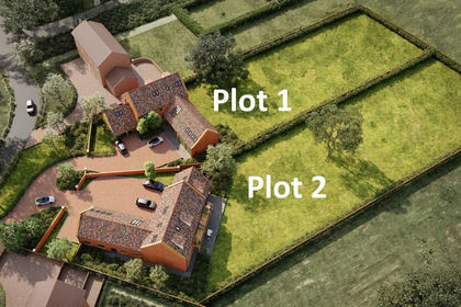
Brown&Co. offers a residential development opportunity in Upwell, Norfolk. Planning permission was granted in February 2023 for two detached dwellings and conversion of a former row of cottages into 3 dwellings on School Road, a pleasant location in a peaceful village, overlooking the river.
DESCRIPTION
Currently the site comprises a former commercial yard with various outbuildings and row of redundant cottages used as a store, with one cottage used as offices. Planning permission was granted by the Borough Council of King's Lynn and West Norfolk under reference 22/01717/F for conversion of the cottage row into 3 dwellings and two further new dwellings in the yard. Details of the application can be searched on the Borough Council website using the reference or by contacting the agent.
LOCATION
The property occupies a quiet position on the edge of Upwell with rural farmland views to the front. The village, which has the River Nene (Old Course) running through it, has a most relaxed atmosphere where narrow boats and pleasure canoes can be frequently seen passing through. The village is a popular choice for local people and newcomers to the area, partly due to the village's easy access to the larger towns of Downham Market and Wisbech as well as being within easy reach of two railway stations. Nearby Downham Market, 8.2 miles, is a mainline station to Ely, Cambridge and London and Manea Station, 9.5 miles, has frequent trains to Peterborough station where national services depart.
VIEWING
Viewing is strictly by appointment with the selling agents. Interested parties are, under no circumstances, to enter the property or yard.
HEALTH AND SAFETY
Viewers should be careful and vigilant whilst on the property. Neither the Seller nor the Selling Agents are responsible for the safety of those viewing the property and accordingly those viewing the property do so at their own risk
SERVICES AND OTHER INFORMATION
Mains water, electric and private drainage.
PLANS, AREAS AND SCHEDULES
These have been prepared as carefully as possible and are based on the Ordnance Survey scale plans and HM Land Registry. All plans are published here are for identification and indicative purposes only and are believed to be correct however in no way should be relied upon.
WAYLEAVES, EASEMENTS & RIGHTS OF WAY
The site is sold subject to and with the benefit of all existing rights, including rights of way, whether public or private, light, support, drainage, water and electricity supplies and other rights, easements, quasi-easements and all wayleaves whether referred to or not in these particulars.
DISPUTES
Should any dispute arise as to the boundaries or any point arising in these Particulars, schedule, plan or interpretation of any of them the question shall be referred to the arbitration of the Selling Agents, whose decision acting as expert shall be final. The Buyer shall be deemed to have full knowledge of all boundaries and neither the Seller nor the Selling Agents will be responsible for defining the boundaries or the ownership thereof.
ANTI-MONEY LAUNDERING
In accordance with the most recent Anti-Money Laundering legislation, a Buyer will be required to provide proof of identity and address to the Sellers' Agents once an offer is submitted and prior to Solicitors being instructed.
SELLING AGENT
Brown & Co LLP Market
Chambers, 25-26 Tuesday Market Place, King's Lynn, PE30 1JJ.
Map Location
Property details
- Tenure
- Freehold
- Council Tax Band
- Ask Agent
- Date Posted
- 2026-09-30
Utilities & Restrictions
Utilities
- Electricity
- Ask Agent
- Water
- Ask Agent
- Heating
- Ask Agent
- Broadband
- Ask Agent
- Sewerage
- Ask Agent
Rights & Restrictions
- Public Rights of Way
- Ask Agent
- Private Rights of Way
- Ask Agent
- Listed Property
- Ask Agent
- Restrictions
- Ask Agent
Listed status, conservation areas and planning constraints for this location are in the full report.
Property Features
- Accessibility
- Ask Agent
- Parking
- Ask Agent
- Garden
- Garden
Beyond the particulars: planning activity, flood history, heritage and ground risks, checked for this exact spot.
Connectivity
Broadband
No premises records for this postcode, which is common for bare land and rural plots. A new connection would be quoted by the provider.
Mobile signal
No address-level signal records for this postcode, which is common for bare land.
Ofcom Connected Nations postcode-level predictions. Speeds and signal are modelled, not measured, and vary between addresses and providers.
Signal is the easy part. Planning activity, flood history and protected designations here are in the full report.
Nearest Schools
Primary
- Upwell Academy187 metresOfsted report card · May 2026
- Ages
- 4 to 11
- Pupils
- 180
- Type
- Academy sponsor led
- Beaupre Community Primary School1.6 milesOfsted report card · Mar 2026
- Ages
- 4 to 11
- Pupils
- 145
- Type
- Community school
- Friday Bridge Community Primary School2.6 milesOfsted: Good
- Ages
- 4 to 11
- Pupils
- 89
- Type
- Community school
- Emneth Academy3.1 milesOfsted: Good
- Ages
- 4 to 11
- Pupils
- 209
- Type
- Academy sponsor led
- Townley Primary School3.1 milesOfsted: Good
- Ages
- 2 to 11
- Pupils
- 102
- Type
- Community school
Secondary
- Thomas Clarkson Academy4.6 milesOfsted: Good
- Ages
- 11 to 18
- Pupils
- 1,295
- Type
- Academy sponsor led
- The Wisbech Academy4.7 milesNo Ofsted rating
- Ages
- 11 to 16
- Pupils
- 205
- Type
- Free schools
- Neale-Wade Academy6.3 milesOfsted report card · Jan 2026
- Ages
- 11 to 18
- Pupils
- 1,130
- Type
- Academy sponsor led
- Marshland High School7.2 milesNo Ofsted rating
- Ages
- 11 to 16
- Pupils
- 821
- Type
- Academy sponsor led
- Downham Market Academy7.7 milesOfsted: Good
- Ages
- 11 to 18
- Pupils
- 1,329
- Type
- Academy sponsor led
Distances are straight-line from the advertised location. Source: the national school registers (DfE, Welsh Government, Scottish Government) and Ofsted.
Schools are just the start: sold prices nearby, planning activity and any flood history are in the full report.
Amenities
Supermarket
GP surgery
Pharmacy
Hospital
Green space
Straight-line distances from the advertised location. Sources: NHS records, Geolytix supermarket locations, OS Open Greenspace and the national trails registers.
The area stacks up? Now check the location itself: planning nearby, protected designations and past flooding.
Getting Around
Nearest station
Nearest bus stop
Typical drive times
Straight-line distances from the advertised location; drive times are typical free-flow times over OpenStreetMap road data, so allow more at peak. Public transport locations from DfT NaPTAN.
Easy to reach matters. So do planning activity, flood history and ground risks: all in the full report.
Flood Risk
Environment Agency open data, checked around the advertised map pin for the listed acreage. Long-term risk counts flood defences; the planning map's flood zones do not. Provided by LandSale, not the listing agent, and not part of the agent's particulars. Risk varies across a holding, so verify before committing.
Rivers and the sea
Planning map: Flood Zone 3.
Surface water
These bandings are the summary. Where this location sits on the flood maps, plus planning activity, heritage and ground risks, is in the full report.
Important notice: Information, maps and tags on this page are drawn from the advertising agent's marketing materials or generated automatically. LandSale has not verified them. Relying on these details is at your own risk, always carry out independent checks before committing to a purchase.
LandSale full disclaimer
Marketing information only - not formal particulars. The details on this website are provided for general guidance and do not constitute an offer or contract. Neither LandSale nor the advertising estate/land agent accepts responsibility for any inaccuracy.
1. Source of information
- Listing content: Core description, asking price, tenure, measurements, photographs and planning history originate from the marketing materials of the advertising estate or land agent. LandSale does not author this content and cannot guarantee its accuracy.
- Automated tags & categorisation: Property type, land-use class, acreage bands and similar labels may be applied by machine-learning models. They are intended as a helpful guide only and may not reflect the property's legal status or permitted use.
- Third-party & enriched data layers: Maps, boundary outlines, planning designations, soil reports, broadband coverage and other environmental or location-based insights are licensed from external suppliers. Such data are supplied “as is", may be incomplete or out of date and are subject to change without notice.
2. Verification required
Prospective purchasers must verify critical matters, including but not limited to planning permission, title boundaries, public rights of way, environmental constraints, acreage, services, access and VAT status, through their own inspections, specialist surveys, legal advisers and the selling agent before relying on the information or entering into any contract.
3. No warranty or liability
LandSale gives no warranty, express or implied, as to the accuracy, completeness or fitness for any particular purpose of the information displayed. LandSale shall not be liable for any loss, damage, cost or expense arising directly or indirectly from any use of or reliance on such information, save where liability may not be excluded by law.
4. Updates & feedback
If you believe any detail on this listing is inaccurate, please let us know. We will investigate and, where appropriate, update the listing or notify the agent.
© LandSale | Version 1.3 - August 2026
Listing agent
Brown & Co, King's Lynn
Market Chambers, 25-26 Tuesday Market Place, Kings Lynn, PE30 1JJ
Contact Brown & Co, King's Lynn
Market Chambers, 25-26 Tuesday Market Place, Kings Lynn, PE30 1JJ
View agent profileSimilar properties for sale
- Price
- £485,000
- Size
- 1.5 acres
Mouth Lane, Guyhirn, PE13, Wisbech St. Mary, Cambridgeshire PE13 England
Added on 25/03/2026Self Build Plot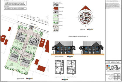
- Price
- Guide Price£400,000
- Size
- 0.5 acres
Leverington Road, Wisbech, PE13, Wisbech, Cambridgeshire PE13 England
Added on 29/01/2026Development Land
- Price
- Guide Price£575,000
Westfield Road, Manea, March, Cambridgeshire, PE15, Manea, Cambridgeshire PE15 England
Added on 18/06/2026Development Land Added on 14/09/2026Development Land
- Price
- Guide Price£395,000
- Size
- 0.38 acres
26 Station Road, Gedney Hill, PE12, Gedney Hill, Lincolnshire PE12 England
Added on 14/08/2026Building Plot
- Price
- Guide Price£430,000
- Size
- 1 acres
Wretton Road, Stoke Ferry, PE33, Stoke Ferry, Norfolk PE33 England
Added on 29/01/2026Redevelopment Land Added on 11/07/2026Building Plot
- Price
- Guide Price£600,000
- Size
- 0.74 acres
Added on 29/01/2026Development Land
- Price
- Guide Price£375,000
- Size
- 0.4 acres
Old Bury Road, Lackford, Bury St. Edmunds, Lackford, Suffolk IP28 England
Added on 18/08/2026Building Plot
- Price
- Guide Price£395,000
- Size
- 0.22 acres
Church Lane, Cheveley, Newmarket, Cambridgeshire, CB8, Cheveley, Cambridgeshire CB8 England
Added on 09/06/2026Building Plot