Dukesfield, Bamburgh, NE69
- Land size
- 0.43 acres
- Bedrooms
- 4
- Bathrooms
- 4
Key Features
- A rare opportunity to build a new home on the Northumberland coast
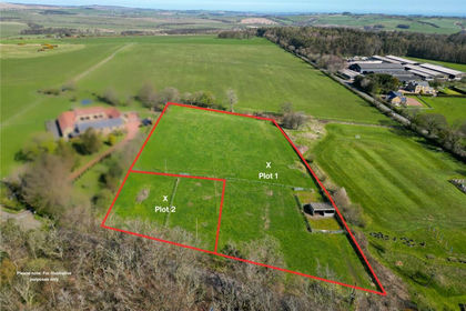
- Building plot of approximately 0.43 acres (0.175 ha) on the edge of Bamburgh
- Four bedrooms, four bathrooms (three en suite) and three reception rooms, in around 315 sq m (3,390 sq ft)
- Open-plan kitchen, dining and family space opening onto a south-facing garden
- Full planning permission (ref. 25/04592/FUL) and a signed Section 106 agreement
- Views towards the coast and Bamburgh Castle
- Integral double garage with EV charging and parking for five vehicles in total
Description
New-build opportunities on the Northumberland coast are rare, and rarer still this close to Bamburgh. This plot sits in the hamlet of Dukesfield, just 1km from the village, surrounded by open farmland and looking out towards the sea and Bamburgh Castle.
It comes with full planning permission and a signed Section 106 agreement for a substantial four-bedroom family home. The house has been designed by JDDK Architects, a leading Newcastle practice, to suit its setting and to be a home that works for everyday family life.
The House
JDDK's design takes its lead from Dukesfield itself. The house follows the pattern of the homes along the lane, with eaves at a similar height to its neighbour, so it sits naturally among them. Its front elevation draws on the hamlet's Grade II listed farmhouse, one of the area's original buildings. The walls are coursed random rubble stone with dressed stone detailing, under a slate roof, with white-painted timber windows, a stone-based bay window and an oak-framed entrance porch.
The rear of the house takes a more contemporary approach, facing the private garden. A zinc standing-seam roof with rooflights runs across the main living space, and wide aluminium sliding doors open the house onto the terrace. Oversailing roofs shade the south-west elevation in summer, and the house is oriented to catch the sun and frame views to both the east and the west.
Inside, the house is designed around the way families live. The ground floor extends to around 174 sq m, with generous 2.6m ceilings throughout. A welcoming entrance hall leads to a drawing room with a fireplace, a comfortable retreat for quieter evenings. There is also a separate study for working from home and a cloakroom.
The heart of the house is the open-plan kitchen, dining and family space across the back. Rooflights fill it with daylight, and the sliding doors connect it to the garden, making it the natural place to cook, eat and spend time together. A utility room links through to the integral double garage, with EV charging, so it works as a practical everyday entrance for muddy boots, beach bags and dogs.
The first floor extends to around 141 sq m. It has four well-proportioned bedrooms, including a principal suite with a dressing room and en suite, along with further en suite facilities and a family bathroom. Dormer windows to the rear bring in light and outlook.
The result is a house that looks rooted in its surroundings from the lane, while offering bright, open living space for a growing family.
Outside
The house is set towards the north of the plot, which leaves a generous south-facing garden for children to play in and for long summer evenings. A rear terrace steps down onto lawn. The consented scheme includes a timber post and rail boundary, a new native hedge along the roadside and wildflower verges. There is parking for five cars, including the double garage, along with space set aside for a bike store and an air source heat pump.
Sustainability
The house is oriented to capture solar gain, with oversailing roofs providing summer shading. It is designed for high levels of insulation and airtightness and for natural cross-ventilation. Heating will come from an air source heat pump, and the design specifies locally sourced materials.
The Lifestyle
Picture mornings with the castle on the horizon and afternoons on the beach, just 1km away. Bamburgh's wide sands, the dunes and the village's tearooms, pubs and delis are an easy walk or a two-minute drive. Budle Bay, known for its birdlife and big skies, is a few minutes away, and Bamburgh Castle Golf Club is nearby. Seahouses is a short drive down the coast, with boat trips to the Farne Islands and their puffins and seals. Holy Island and Lindisfarne Castle are within easy reach to the north.
Dukesfield itself is quiet and rural: a small cluster of homes around a historic farmstead, with farmland on every side. It suits a permanent family home that offers space, calm and a strong connection to the landscape, with village life close by.
Planning
Full planning permission has been granted by Northumberland County Council under reference 25/04592/FUL, and the Section 106 agreement has been signed. The property is subject to a primary occupancy restriction, so it must be occupied as the owner's principal residence and cannot be used as a second home or holiday let.
The plans, Design and Access Statement, decision notice and Section 106 agreement are all available from Northumberland Properties on request. The planning documents can also be viewed on the council's planning portal.
Tenure: Freehold
Services: Mains water and electricity. Drainage will be to a private sewage treatment plant.
Viewing: The plot can be viewed from the public highway at any time. Access onto the plot itself is strictly by appointment only. Please contact Northumberland Properties to arrange a visit.
Sale boundary: The red line shown on the plans in this listing is the planning application boundary, not the boundary of the land for sale. It includes a narrow strip of land running north from the plot, which provides the drainage connection required under the planning permission. This strip is not included in the freehold sale. The vendor will grant the buyer an easement to lay, connect to, use, maintain and repair the drainage within it. A plan showing the sale boundary is available from Northumberland Properties on request.
Please note: The images of the house in this listing are computer-generated images (CGIs). They illustrate how the consented house could look, based on the approved plans, and do not show a building that currently exists. The plot is currently undeveloped land. Finishes, landscaping and surroundings shown are indicative only. Buyers should refer to the approved plans and planning documents, available from Northumberland Properties, for full details of the permitted scheme.
Garden
Large south facing garden
Parking - Double garage
Parking - Driveway
Map Location
Property details
- Tenure
- Freehold
- Council Tax Band
- Ask Agent
- Date Posted
- 2026-09-30
Utilities & Restrictions
Utilities
- Electricity
- Mains
- Water
- Mains
- Heating
- Air Source Heat Pump
- Broadband
- Full Fibre (FTTP)
- Sewerage
- Septic Tank / Private
Rights & Restrictions
- Public Rights of Way
- Ask Agent
- Private Rights of Way
- Ask Agent
- Listed Property
- Ask Agent
- Restrictions
- Ask Agent
Listed status, conservation areas and planning constraints for this location are in the full report.
Property Features
- Accessibility
- Ask Agent
- Parking
- Garage, Driveway
- Garden
- Private Garden
Beyond the particulars: planning activity, flood history, heritage and ground risks, checked for this exact spot.
Connectivity
Broadband
Fastest speed available at this postcode
1.8 Gbps
Gigabit full fibre · available to 91% of premises
Suitable for
- 4K streaming on every screen
- Full-time home working
- Online gaming & big downloads
Mobile signal
Predicted 4G and 5G signal; indoor signal depends on building materials.
Ofcom Connected Nations postcode-level predictions. Speeds and signal are modelled, not measured, and vary between addresses and providers.
Signal is the easy part. Planning activity, flood history and protected designations here are in the full report.
Nearest Schools
Primary
- Seahouses Primary School3.3 milesNo Ofsted rating
- Ages
- 4 to 11
- Pupils
- 60
- Type
- Community school
- Belford Primary School4 milesOfsted: Good
- Ages
- 2 to 11
- Pupils
- 90
- Type
- Community school
- Holy Island Church of England Primary School5.6 milesOfsted: Good
- Ages
- 3 to 11
- Pupils
- 8
- Type
- Voluntary aided school
- Faith
- Church of England
- Ellingham Church of England Primary School5.6 milesNo Ofsted rating
- Ages
- 2 to 11
- Pupils
- 46
- Type
- Academy converter
- Faith
- Church of England
- Embleton Vincent Edwards Church of England Primary School8.1 milesOfsted: Good
- Ages
- 3 to 11
- Pupils
- 69
- Type
- Academy converter
- Faith
- Church of England
Secondary
- The Duchess's Community High School14 milesOfsted: Requires improvement
- Ages
- 11 to 18
- Pupils
- 1,276
- Type
- Academy converter
- Berwick Academy15 milesOfsted: Requires improvement
- Ages
- 13 to 18
- Pupils
- 601
- Type
- Academy converter
- James Calvert Spence College20 milesOfsted: Good
- Ages
- 11 to 19
- Pupils
- 567
- Type
- Community school
- Dr Thomlinson Church of England Middle School22 milesNo Ofsted rating
- Ages
- 9 to 13
- Pupils
- 184
- Type
- Academy converter
- Faith
- Church of England
- The King Edward VI School30 milesOfsted: Good *
- Ages
- 13 to 18
- Pupils
- 1,426
- Type
- Academy converter
* Latest graded judgement covers quality of education only; no overall grade was issued under the 2024-25 inspection framework.
Distances are straight-line from the advertised location. Source: the national school registers (DfE, Welsh Government, Scottish Government) and Ofsted.
Schools are just the start: sold prices nearby, planning activity and any flood history are in the full report.
Amenities
Supermarket
GP surgery
Pharmacy
Hospital
Straight-line distances from the advertised location. Sources: NHS records, Geolytix supermarket locations, OS Open Greenspace and the national trails registers.
The area stacks up? Now check the location itself: planning nearby, protected designations and past flooding.
Getting Around
Nearest station
Nearest bus stop
Typical drive times
Straight-line distances from the advertised location; drive times are typical free-flow times over OpenStreetMap road data, so allow more at peak. Public transport locations from DfT NaPTAN.
Easy to reach matters. So do planning activity, flood history and ground risks: all in the full report.
Flood Risk
Environment Agency open data, checked around the advertised map pin for the listed acreage. Long-term risk counts flood defences; the planning map's flood zones do not. The map pin for this listing is approximate, so these readings describe the surrounding area. Provided by LandSale, not the listing agent, and not part of the agent's particulars. Risk varies across a holding, so verify before committing.
Rivers and the sea
Planning map: Flood Zone 1.
Surface water
Not at the pin: mapped about 10 metres away.
These bandings are the summary. Where this location sits on the flood maps, plus planning activity, heritage and ground risks, is in the full report.
Important notice: Information, maps and tags on this page are drawn from the advertising agent's marketing materials or generated automatically. LandSale has not verified them. Relying on these details is at your own risk, always carry out independent checks before committing to a purchase.
LandSale full disclaimer
Marketing information only - not formal particulars. The details on this website are provided for general guidance and do not constitute an offer or contract. Neither LandSale nor the advertising estate/land agent accepts responsibility for any inaccuracy.
1. Source of information
- Listing content: Core description, asking price, tenure, measurements, photographs and planning history originate from the marketing materials of the advertising estate or land agent. LandSale does not author this content and cannot guarantee its accuracy.
- Automated tags & categorisation: Property type, land-use class, acreage bands and similar labels may be applied by machine-learning models. They are intended as a helpful guide only and may not reflect the property's legal status or permitted use.
- Third-party & enriched data layers: Maps, boundary outlines, planning designations, soil reports, broadband coverage and other environmental or location-based insights are licensed from external suppliers. Such data are supplied “as is", may be incomplete or out of date and are subject to change without notice.
2. Verification required
Prospective purchasers must verify critical matters, including but not limited to planning permission, title boundaries, public rights of way, environmental constraints, acreage, services, access and VAT status, through their own inspections, specialist surveys, legal advisers and the selling agent before relying on the information or entering into any contract.
3. No warranty or liability
LandSale gives no warranty, express or implied, as to the accuracy, completeness or fitness for any particular purpose of the information displayed. LandSale shall not be liable for any loss, damage, cost or expense arising directly or indirectly from any use of or reliance on such information, save where liability may not be excluded by law.
4. Updates & feedback
If you believe any detail on this listing is inaccurate, please let us know. We will investigate and, where appropriate, update the listing or notify the agent.
© LandSale | Version 1.3 - August 2026
Listing agent
Northumberland Properties (Alnwick), Alnwick
12 Market Street, Alnwick, NE66 1TL
Contact Northumberland Properties (Alnwick), Alnwick
12 Market Street, Alnwick, NE66 1TL
View agent profileSimilar properties for sale
- Price
- Guide Price£325,000
- Size
- 2.66 acres
Added on 14/05/2026Self Build Plot
- Price
- Offers Over£300,000
Added on 14/10/2026Building Plot
- Price
- Offers in Region of£400,000
Added on 08/08/2026Development Land
- Price
- Guide Price£280,000
Added on 29/01/2026Building Plot
- Price
- Offers Over£315,000
- Size
- 3.15 acres
Added on 29/01/2026Development Land
- Price
- Offers in Excess of£300,000
Longhorsley, Morpeth, Northumberland, NE65, Longhorsley, Northumberland NE65 England
Added on 15/09/2026Development Land
- Price
- Guide Price£320,000
- Size
- 1.47 acres
Angerton Broom House, Hartburn, Morpeth, Northumberland, NE61, Hartburn, Northumberland NE61 England
Added on 08/08/2026Development Land
- Price
- Guide Price£545,000
- Size
- 0.88 acres
Field House, Hepscott, Northumberland, NE61, Hepscott, Northumberland NE61 England
Added on 17/04/2026Development Land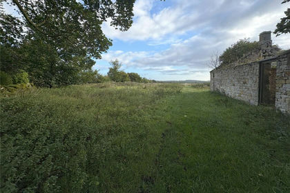
- Price
- From£350,000
- Size
- 0.29 acres
Ingoe, Near Ponteland, Northumberland, NE20, Matfen, Northumberland NE20 England
Added on 07/03/2026Building Plot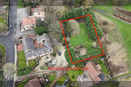
- Price
- Offers in Excess of£325,000
Added on 22/04/2026Self Build Plot