Land, barn and 4 parking spaces at Royal court Eye Road, Dogsthorpe, Peterborough
- Use Class
- Use Class: 8
Key Features
- RARE FREEHOLD BUILDING, LAND & FOUR PARKING SPACES
- SEMI-DETACHED SINGLE-STOREY BUILDING
- DEVELOPMENT / CHANGE OF USE POTENTIAL – STP
- PREVIOUS RESIDENTIAL PLANNING APPLICATION – 19/01143/FUL
- IDEAL FOR BUILDERS, DEVELOPERS & INVESTORS
- Opportunity for BUILDERS, DEVELOPERS & INVESTORS
- ALL FUTURE USES & DEVELOPMENT SUBJECT TO NECESSARY CONSENTS
- FREEHOLD SALE INCLUDING FOUR PARKING SPACES
- Property offered AS SEEN NOT VIEWABLE
- ALL OFFERS IN WRITING BY 9TH OCTOBER 2026
Description
FREEHOLD OPPORTUNITY – LAND WITH BUILDING & FOUR PARKING SPACES GUIDE PRICE £40,000 - £60,000
ALL OFFERS IN WRITING BY 9th OCTOBER 2026 BY 5PM
Sell New Group are pleased to offer for sale this unusual FREEHOLD OPPORTUNITY, situated within the established Royal Court residential development, just off Eye Road, Peterborough.
The sale comprises an existing single-storey semi-detached building, adjoining the neighbouring barn/building, together with its associated parcel of land and FOUR PARKING SPACES.
Currently presented in a derelict condition and requiring substantial refurbishment, the property represents an interesting opportunity for builders, developers, investors or owner-occupiers looking to acquire a freehold building and land with potential to add value.
Constructed predominantly of brick beneath a pitched tiled roof, the building provides a blank canvas from which an incoming purchaser may wish to investigate its future potential. Possibilities could include refurbishment and reuse, conversion, change of use or redevelopment, subject in all cases to obtaining the necessary planning permission and other consents.
Purchasers should note that the building is SEMI-DETACHED and directly adjoins the neighbouring barn/building.
PLANNING HISTORY
The property forms part of the wider Royal Court development, created through the redevelopment of the former Royal Arms Public House site.
The wider residential development has planning history under reference 14/01017/FUL, relating to the demolition of the former public house and construction of 20 two-bedroom flats, together with associated parking, landscaping and cycle-storage provision.
Of particular interest to developers and purchasers considering the future potential of the property is a subsequent planning application at Royal Court:
PLANNING REFERENCE: 19/01143/FUL
The application proposed:
“Demolition of existing ancillary building, construction of single storey 2 bedroom dwelling…”
The application was subsequently WITHDRAWN on 4 October 2019 and therefore does not constitute an existing or extant planning permission.
Nevertheless, the application provides useful planning history for purchasers wishing to investigate the site's future potential, demonstrating that the possibility of replacing an ancillary building at Royal Court with a residential dwelling has previously been explored through the formal planning process.
Prospective purchasers are encouraged to review the full planning history, including application 19/01143/FUL, together with its submitted plans and supporting documentation, and obtain independent planning advice before considering any future proposal.
DEVELOPMENT / CHANGE OF USE POTENTIAL
Given the existing building, freehold land and four parking spaces included within the sale, an incoming purchaser may wish to investigate a variety of future options.
These could potentially include refurbishment and reuse of the existing building, conversion, alternative commercial or ancillary uses, change of use or redevelopment, subject to obtaining all necessary planning permissions and other consents.
A purchaser may also wish to investigate whether a revised residential proposal could be considered appropriate, particularly taking into account the previous 2019 planning application and current planning policies.
The previous residential application was withdrawn, and purchasers should therefore not assume that residential development will be permitted.
No representation or warranty is made by the seller or Sell New Group that planning permission will be granted for residential development, change of use, conversion or any other proposal.
THE BUILDING
The existing single-storey building is predominantly of brick construction beneath a pitched tiled roof and is currently in a derelict condition requiring substantial refurbishment and improvement.
The building is SEMI-DETACHED, directly adjoining the neighbouring barn/building.
The property is being sold in its existing condition, and prospective purchasers must satisfy themselves as to its structural condition and suitability for their intended use.
Purchasers should also investigate any relevant party wall or shared wall arrangements, boundaries, rights, covenants and maintenance responsibilities affecting the adjoining structure.
LAND & FOUR PARKING SPACES
The sale includes the building together with its associated FREEHOLD LAND AND FOUR PARKING SPACES, as identified within the relevant title and sales documentation.
The property sits within the established Royal Court development and is accessed through the existing development.
Purchasers and their legal advisers will be responsible for establishing the precise extent of the title and confirming all rights of access, rights of way, parking rights, shared access arrangements, estate charges, maintenance liabilities, restrictive covenants and other matters affecting the property.
SERVICES
The availability, location, capacity and condition of services serving the property have not been independently verified or tested by the selling agent.
Prospective purchasers must undertake their own investigations regarding electricity, mains water, foul and surface-water drainage, telecommunications and any other services required for their proposed use.
Any new connections, alterations or upgrades required for refurbishment, change of use or redevelopment will be the responsibility of the purchaser.
LOCATION
Royal Court is situated just off Eye Road in Peterborough, within an established residential area providing convenient access to the city and surrounding road network.
The property occupies a tucked-away position within the Royal Court development and is surrounded predominantly by established residential accommodation.
A range of everyday amenities, shops, schools and services can be found within the surrounding area, while Peterborough city centre provides a wider selection of shopping, leisure, employment and recreational facilities.
Peterborough Railway Station provides mainline rail connections, including services towards London, while the city's road network provides convenient access to surrounding towns and major routes.
For investors, builders and developers, the combination of an existing freehold building, land, four parking spaces and documented previous planning history creates an unusual opportunity to investigate.
VIEWINGS
Viewings are strictly by prior appointment only and must be undertaken during daylight hours.
Due to the current condition of the building, purchasers should exercise appropriate care when inspecting the property. Please contact Sell New Group to arrange an accompanied inspection.
IMPORTANT PLANNING & BUYER NOTICE
Planning application 19/01143/FUL was WITHDRAWN and does not represent an existing or extant planning permission.
Reference to previous planning proposals is provided for information purposes only and should not be interpreted as confirmation that the same or any similar development would now receive planning permission.
No representation or warranty is made by the seller or Sell New Group regarding the suitability of the property for residential development, commercial use, conversion, change of use, refurbishment or redevelopment.
All interested parties must undertake their own investigations and due diligence with Peterborough City Council and obtain independent planning, legal, structural and other professional advice before entering into a purchase.
No measurements have been taken as access to the plot/building was not available at the time of preparing these particulars. Any boundaries, dimensions or areas shown within the marketing material or plans are approximate and for identification purposes only. Buyers and their solicitors should verify the precise title extent, boundaries, measurements, parking spaces, access rights and all other legal matters.
IMPORTANT NOTICE
All information is provided in good faith but must not be relied upon as statements or representations of fact. Prospective purchasers must satisfy themselves by inspection, survey, legal enquiries and independent professional advice regarding planning, measurements, boundaries, access, services and utilities, flood risk, environmental matters, structural condition, legal title and suitability for their intended use.
Any proposed use, alteration or development will be subject to obtaining all necessary statutory and other consents.
BUYER'S ADMINISTRATION FEE: The successful purchaser will be required to pay a fixed administration fee of £3,600 inclusive of VAT, in addition to the agreed purchase price.
DISCLAIMER
Sell New Group are acting as agents for the vendors of this property. The purchaser's conveyancer is responsible for ensuring that the purchase documentation and legal enquiries adequately protect the purchaser's position.
We make detailed enquiries of the vendor to ensure that the information provided is as accurate as reasonably possible. Please inform us if you become aware of any information that may be inaccurate.
RESERVATION REQUIREMENTS
On reservation, Sell New Group will require:
AML identification checks for all purchasers
Proof of deposit and/or proof of funds
Mortgage Agreement in Principle, where applicable
Selling estate agent's details, where applicable
A £2,000 non-refundable reservation deposit, which will be deducted from the agreed purchase price on completion
The reservation is made strictly on the basis that all parties will work towards a four-week exchange of contracts deadline, commencing from the date the purchaser's solicitor receives the legal contract documentation.
Prospective purchasers should ensure they are satisfied with the above requirements and obtain appropriate legal advice before paying any reservation deposit.
Map Location
Property details
- Tenure
- Freehold
- Council Tax Band
- Ask Agent
- Date Posted
- 2026-09-23
Utilities & Restrictions
Utilities
- Electricity
- Ask Agent
- Water
- Ask Agent
- Heating
- Ask Agent
- Broadband
- Ask Agent
- Sewerage
- Ask Agent
Rights & Restrictions
- Public Rights of Way
- Ask Agent
- Private Rights of Way
- Ask Agent
- Listed Property
- Ask Agent
- Restrictions
- Ask Agent
Listed status, conservation areas and planning constraints for this location are in the full report.
Property Features
- Accessibility
- Ask Agent
- Parking
- Ask Agent
- Garden
- Ask Agent
Beyond the particulars: planning activity, flood history, heritage and ground risks, checked for this exact spot.
Connectivity
Broadband
Fastest speed available at this postcode
5.5 Gbps
Gigabit full fibre
Suitable for
- 4K streaming on every screen
- Full-time home working
- Online gaming & big downloads
Mobile signal
Predicted 4G and 5G signal; indoor signal depends on building materials.
Ofcom Connected Nations postcode-level predictions. Speeds and signal are modelled, not measured, and vary between addresses and providers.
Signal is the easy part. Planning activity, flood history and protected designations here are in the full report.
Nearest Schools
Primary
- Newark Hill Academy115 metresOfsted: Good
- Ages
- 4 to 11
- Pupils
- 435
- Type
- Academy sponsor led
- Lime Academy Parnwell681 metresOfsted: Good
- Ages
- 5 to 11
- Pupils
- 287
- Type
- Academy sponsor led
- St Thomas More Catholic Primary School982 metresOfsted: Good
- Ages
- 4 to 11
- Pupils
- 407
- Type
- Academy converter
- Faith
- Roman Catholic
- Welland Academy0.7 milesOfsted: Good
- Ages
- 4 to 11
- Pupils
- 405
- Type
- Academy sponsor led
- Dogsthorpe Infant School0.7 milesNo Ofsted rating
- Ages
- 5 to 7
- Pupils
- 235
- Type
- Academy converter
Secondary
- City of Peterborough Academy665 metresOfsted: Good
- Ages
- 11 to 16
- Pupils
- 853
- Type
- Free schools
- St John Fisher Catholic High School993 metresNo Ofsted rating
- Ages
- 11 to 18
- Type
- Academy converter
- Faith
- Roman Catholic
- Greater Peterborough UTC0.7 milesOfsted: Good
- Ages
- 11 to 19
- Pupils
- 464
- Type
- University technical college
- Thomas Deacon Academy0.9 milesOfsted: Good *
- Ages
- 7 to 19
- Pupils
- 2,256
- Type
- Academy sponsor led
- The King's (The Cathedral) School1.1 milesOfsted: Outstanding
- Ages
- 7 to 18
- Pupils
- 1,256
- Type
- Academy converter
- Faith
- Church of England
* Latest graded judgement covers quality of education only; no overall grade was issued under the 2024-25 inspection framework.
Distances are straight-line from the advertised location. Source: the national school registers (DfE, Welsh Government, Scottish Government) and Ofsted.
Schools are just the start: sold prices nearby, planning activity and any flood history are in the full report.
Amenities
Supermarket
GP surgery
Pharmacy
Hospital
Green space
Straight-line distances from the advertised location. Sources: NHS records, Geolytix supermarket locations, OS Open Greenspace and the national trails registers.
The area stacks up? Now check the location itself: planning nearby, protected designations and past flooding.
Getting Around
Nearest station
Nearest bus stop
Typical drive times
Straight-line distances from the advertised location; drive times are typical free-flow times over OpenStreetMap road data, so allow more at peak. Public transport locations from DfT NaPTAN.
Easy to reach matters. So do planning activity, flood history and ground risks: all in the full report.
Flood Risk
From Environment Agency long-term flood risk and flood map open data, checked around the advertised map pin and allowing for the listed acreage where known. This summary comes from LandSale, the advertising platform, not from the listing agent, and is not part of the agent's particulars. Risk can vary across a single holding, so verify anything critical through your own searches before committing.
Rivers and the sea
On the flood map for planning, which ignores defences: Flood Zone 1 at the map pin and across the area searched.
Surface water
Also mapped within the area searched, about 30 metres around the pin: a 1 in 100 to 1 in 1000 chance each year from about 10 metres.
Medium to low risk nearbyThese bandings are the summary. Where this location sits on the flood maps, plus planning activity, heritage and ground risks, is in the full report.
Important notice: Information, maps and tags on this page are drawn from the advertising agent's marketing materials or generated automatically. LandSale has not verified them. Relying on these details is at your own risk, always carry out independent checks before committing to a purchase.
LandSale full disclaimer
Marketing information only - not formal particulars. The details on this website are provided for general guidance and do not constitute an offer or contract. Neither LandSale nor the advertising estate/land agent accepts responsibility for any inaccuracy.
1. Source of information
- Listing content: Core description, asking price, tenure, measurements, photographs and planning history originate from the marketing materials of the advertising estate or land agent. LandSale does not author this content and cannot guarantee its accuracy.
- Automated tags & categorisation: Property type, land-use class, acreage bands and similar labels may be applied by machine-learning models. They are intended as a helpful guide only and may not reflect the property's legal status or permitted use.
- Third-party & enriched data layers: Maps, boundary outlines, planning designations, soil reports, broadband coverage and other environmental or location-based insights are licensed from external suppliers. Such data are supplied “as is", may be incomplete or out of date and are subject to change without notice.
2. Verification required
Prospective purchasers must verify critical matters, including but not limited to planning permission, title boundaries, public rights of way, environmental constraints, acreage, services, access and VAT status, through their own inspections, specialist surveys, legal advisers and the selling agent before relying on the information or entering into any contract.
3. No warranty or liability
LandSale gives no warranty, express or implied, as to the accuracy, completeness or fitness for any particular purpose of the information displayed. LandSale shall not be liable for any loss, damage, cost or expense arising directly or indirectly from any use of or reliance on such information, save where liability may not be excluded by law.
4. Updates & feedback
If you believe any detail on this listing is inaccurate, please let us know. We will investigate and, where appropriate, update the listing or notify the agent.
© LandSale | Version 1.3 - August 2026
Listing agent
Sell New Ltd, St. Neots
Contact Sell New Ltd, St. Neots
View agent profileSimilar properties for sale
- Price
- Guide Price£45,000
Holdich Street, Peterborough, Peterborough, Peterborough PE3 England
Added on 14/05/2026Development Land Added on 09/09/2026Development Land
- Price
- Guide Price£40,000
- Size
- 0.03 acres
Added on 23/09/2026Building Plot
- Price
- Guide Price£39,150
Added on 06/08/2026Development Land
- Price
- Guide Price£60,000
Residential Development Site PE12, Holbeach, Lincolnshire PE12 England
Added on 29/01/2026Development Land
- Price
- Guide Price£55,000
- Size
- 4 acres
Added on 23/09/2026Vacant Land
- Price
- £59,950
North End, Swineshead, Boston, Lincolnshire, PE20, Swineshead, Lincolnshire PE20 England
Added on 29/01/2026Building Plot Added on 29/01/2026Building Plot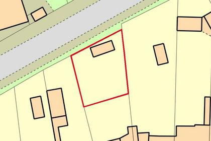
- Price
- Guide Price£37,000
Added on 29/01/2026Undeveloped Land Added on 24/08/2026Building Plot