Two building plots for sale on, Park Road, Swarland, Northumberland.
- Bedrooms
- 3
- Bathrooms
- 2
Key Features
- EXCITING RESIDENTIAL DEVELOPMENT OPPORTUNITY
- TWO BUILDING PLOTS – SOLD TOGETHER AS ONE LOT
- FULL PLANNING PERMISSION FOR TWO DETACHED HOMES
- PLANNING PERMISSION ALREADY IMPLEMENTED
- TWO STYLISH 3 BEDROOM, 2 BATHROOM HOMES
- SPACIOUS STOREY-AND-A-HALF / DORMER-STYLE DESIGNS
- OPEN-PLAN KITCHEN/DINERS, UTILITY ROOMS & FLEXIBLE 4TH ROOMS
- SUPERB, GENEROUS PLOTS WITH EXTENSIVE REAR GARDENS
- GARDENS EXTENDING TOWARDS SWARLAND WOODS, NORTHUMBERLAND
- SHARED DRIVEWAY – READY FOR A DEVELOPER OR SELF-BUILDER TO PROGRESS
Description
Development Opportunity – Two Building Plots with Full Planning Permission on approved application
22/01325/VARYCO. A superb and increasingly rare opportunity to acquire two generous residential building plots, offered together as one lot, with full planning permission for two individually designed three-bedroom detached homes.
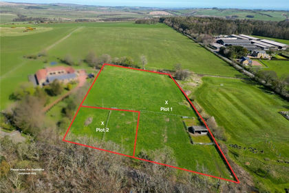
Occupying an attractive position to the rear of Park Road, Swarland, the plots are approached via a shared driveway and enjoy particularly impressive garden plots. Beyond the more conventional garden areas, the land extends significantly further to the rear, running towards Swarland Woods, creating a unique sense of space and a delightful setting for the proposed homes.
Planning permission has been granted – and importantly has already been implemented – for the construction of two substantial three-bedroom, two-bathroom detached properties. Designed in an attractive storey-and-a-half/dormer style, the proposed homes offer spacious and flexible accommodation ideally suited to modern family living.
Each property has been designed to provide three generously proportioned double bedrooms and two bathrooms, together with an impressive open-plan kitchen/dining area, separate utility room and an additional versatile room at ground-floor level. This fourth room could readily serve as a home office, occasional bedroom, children's playroom, snug or hobby room, depending upon the requirements of the eventual owner.
The combination of the attractive house designs, unusually generous plots and woodland backdrop makes this an exciting proposition for a developer, builder or private purchaser looking to create two individual homes.
The two plots are being sold together as a pair and, with the existing planning permission implemented, represent an opportunity to move forward with the development without starting the planning process from scratch.
Purchasers may, of course, wish to explore alternative designs or amendments to the approved scheme, which would be subject to obtaining any necessary further planning permissions and consents.
Full planning documentation, approved drawings and further information are available upon request. Prospective purchasers should satisfy themselves as to the precise planning status, boundaries, services, access arrangements and all other development matters prior to purchase.
Tenure: Freehold
Council Tax Band: To be accessed as land only at present
EPC: Not needed as plots for building
“We are required by law to conduct anti-money laundering checks on all those selling or buying a property. Whilst we retain responsibility for ensuring checks and any ongoing monitoring are carried out correctly, the initial checks are carried out on our behalf by Lifetime Legal who will contact you once you have agreed to instruct us in your sale or had an offer accepted on a property you wish to buy. The cost of these checks is £60 (incl. VAT), which covers the cost of obtaining relevant data and any manual checks and monitoring which might be required. This fee will need to be paid by you in advance of us publishing your property (in the case of a vendor) or issuing a memorandum of sale (in the case of a buyer), directly to Lifetime Legal, and is non-refundable."
Important Note: These particulars, whilst believed to be accurate, are set out as a general guideline and do not constitute any part of an offer or contract. Intending purchasers should not rely on them as statements of representation of fact but must satisfy themselves by inspection or otherwise as to their accuracy. Please note that we have not tested any apparatus, equipment, fixtures, fittings or services including central heating and so cannot verify they are in working order or fit for their purpose. All measurements are approximate and for guidance only. If there is any point that is of particular importance to you, please contact us and we will try and clarify the position for you.
Map Location
Property details
- Tenure
- Freehold
- Council Tax Band
- Ask Agent
- Date Posted
- 2026-09-18
Utilities & Restrictions
Utilities
- Electricity
- Ask Agent
- Water
- Ask Agent
- Heating
- Ask Agent
- Broadband
- Ask Agent
- Sewerage
- Ask Agent
Rights & Restrictions
- Public Rights of Way
- Ask Agent
- Private Rights of Way
- Ask Agent
- Listed Property
- Ask Agent
- Restrictions
- Ask Agent
Listed status, conservation areas and planning constraints for this location are in the full report.
Property Features
- Accessibility
- Ask Agent
- Parking
- Parking Available
- Garden
- Garden
Beyond the particulars: planning activity, flood history, heritage and ground risks, checked for this exact spot.
Connectivity
Broadband
Fastest speed available at this postcode
80 Mbps
Superfast
Suitable for
- HD streaming
- Video calls
- Web & social
Mobile signal
Outdoor predictions; indoor signal depends on building materials.
Ofcom Connected Nations postcode-level predictions. Speeds and signal are modelled, not measured, and vary between addresses and providers.
Signal is the easy part. Planning activity, flood history and protected designations here are in the full report.
Nearest Schools
Primary
- Swarland Primary School0.7 milesOfsted: Good *
- Ages
- 4 to 11
- Pupils
- 76
- Type
- Community school
- Felton Church of England Primary School1.8 milesNo Ofsted rating
- Ages
- 3 to 11
- Pupils
- 102
- Type
- Voluntary controlled school
- Faith
- Church of England
- Shilbottle Primary School4.4 milesOfsted: Good
- Ages
- 4 to 11
- Pupils
- 71
- Type
- Academy converter
- Broomhill Primary School5.2 milesOfsted report card · Jun 2026
- Ages
- 2 to 11
- Pupils
- 80
- Type
- Community school
- Longhorsley St Helen's Church of England Aided First School5.2 milesOfsted report card · Mar 2026
- Ages
- 3 to 9
- Pupils
- 96
- Type
- Voluntary aided school
- Faith
- Church of England
Secondary
- The Duchess's Community High School5.8 milesOfsted: Requires improvement
- Ages
- 11 to 18
- Pupils
- 1,276
- Type
- Academy converter
- James Calvert Spence College5.9 milesOfsted: Good
- Ages
- 11 to 19
- Pupils
- 567
- Type
- Community school
- Dr Thomlinson Church of England Middle School6.3 milesNo Ofsted rating
- Ages
- 9 to 13
- Pupils
- 184
- Type
- Academy converter
- Faith
- Church of England
- The King Edward VI School10 milesOfsted: Good *
- Ages
- 13 to 18
- Pupils
- 1,426
- Type
- Academy converter
- Morpeth Chantry Middle School10 milesOfsted report card · Mar 2026
- Ages
- 9 to 13
- Pupils
- 525
- Type
- Academy converter
* Latest graded judgement covers quality of education only; no overall grade was issued under the 2024-25 inspection framework.
Distances are straight-line from the advertised location. Source: the national school registers (DfE, Welsh Government, Scottish Government) and Ofsted.
Schools are just the start: sold prices nearby, planning activity and any flood history are in the full report.
Amenities
Supermarket
GP surgery
Pharmacy
Hospital
Green space
Straight-line distances from the advertised location. Sources: NHS records, Geolytix supermarket locations, OS Open Greenspace and the national trails registers.
The area stacks up? Now check the location itself: planning nearby, protected designations and past flooding.
Getting Around
Nearest station
Nearest bus stop
Typical drive times
Straight-line distances from the advertised location; drive times are typical free-flow times over OpenStreetMap road data, so allow more at peak. Public transport locations from DfT NaPTAN.
Easy to reach matters. So do planning activity, flood history and ground risks: all in the full report.
Flood Risk
From Environment Agency flood map open data, checked around the advertised map pin and allowing for the listed acreage where known. This summary comes from LandSale, the advertising platform, not from the listing agent, and is not part of the agent's particulars. Risk can vary across a single holding, so verify anything critical through your own searches before committing.
Rivers and the sea
Surface water
These bandings are the summary. Where this location sits on the flood maps, plus planning activity, heritage and ground risks, is in the full report.
Important notice: Information, maps and tags on this page are drawn from the advertising agent's marketing materials or generated automatically. LandSale has not verified them. Relying on these details is at your own risk, always carry out independent checks before committing to a purchase.
LandSale full disclaimer
Marketing information only - not formal particulars. The details on this website are provided for general guidance and do not constitute an offer or contract. Neither LandSale nor the advertising estate/land agent accepts responsibility for any inaccuracy.
1. Source of information
- Listing content: Core description, asking price, tenure, measurements, photographs and planning history originate from the marketing materials of the advertising estate or land agent. LandSale does not author this content and cannot guarantee its accuracy.
- Automated tags & categorisation: Property type, land-use class, acreage bands and similar labels may be applied by machine-learning models. They are intended as a helpful guide only and may not reflect the property's legal status or permitted use.
- Third-party & enriched data layers: Maps, boundary outlines, planning designations, soil reports, broadband coverage and other environmental or location-based insights are licensed from external suppliers. Such data are supplied “as is", may be incomplete or out of date and are subject to change without notice.
2. Verification required
Prospective purchasers must verify critical matters, including but not limited to planning permission, title boundaries, public rights of way, environmental constraints, acreage, services, access and VAT status, through their own inspections, specialist surveys, legal advisers and the selling agent before relying on the information or entering into any contract.
3. No warranty or liability
LandSale gives no warranty, express or implied, as to the accuracy, completeness or fitness for any particular purpose of the information displayed. LandSale shall not be liable for any loss, damage, cost or expense arising directly or indirectly from any use of or reliance on such information, save where liability may not be excluded by law.
4. Updates & feedback
If you believe any detail on this listing is inaccurate, please let us know. We will investigate and, where appropriate, update the listing or notify the agent.
© LandSale | Version 1.3 - August 2026
Listing agent
Elizabeth Humphreys Homes, Swarland
Casey Lodge Park Road, Swarland, NE65 9JD
Contact Elizabeth Humphreys Homes, Swarland
Casey Lodge Park Road, Swarland, NE65 9JD
View agent profileSimilar properties for sale
- Price
- Guide Price£325,000
- Size
- 2.66 acres
Added on 14/05/2026Self Build Plot
- Price
- Guide Price£225,000
- Size
- 0.36 acres
Added on 14/05/2026Self Build Plot
- Price
- Offers in Excess of£300,000
Longhorsley, Morpeth, Northumberland, NE65, Longhorsley, Northumberland NE65 England
Added on 15/09/2026Development Land
- Price
- Guide Price£280,000
Added on 29/01/2026Building Plot Added on 24/06/2026Development Land
- Price
- Guide Price£320,000
- Size
- 1.47 acres
Angerton Broom House, Hartburn, Morpeth, Northumberland, NE61, Hartburn, Northumberland NE61 England
Added on 08/08/2026Development Land
- Price
- £225,000
- Size
- 0.5 acres
Added on 29/01/2026Building Plot
- Price
- From£350,000
- Size
- 0.29 acres
Ingoe, Near Ponteland, Northumberland, NE20, Matfen, Northumberland NE20 England
Added on 07/03/2026Building Plot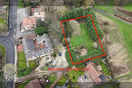
- Price
- Offers in Excess of£325,000
Added on 22/04/2026Self Build Plot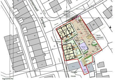
- Price
- Guide Price£295,000
- Size
- 0.31 acres
Former Miners Hall, Crawcrook, Tyne and Wear, NE40, Blaydon and Consett, Gateshead NE40 England
Added on 29/01/2026Redevelopment Land