Fleggburgh Road, Rollesby
- Land size
- 0.75 acres
Key Features
- Guide Price: £160,000 - £170,000
- Approximately 0.75 acres (STMS) with open countryside to front and rear
- Norfolk red brick and tile barn within the curtilage of a Grade II listed building
- Potential to reinstate former barn and eight-bay cart lodge (STPP)
- Rare development opportunity in a sought-after Norfolk village setting
- Gated site enjoying privacy, space and attractive rural surroundings
- Eight-bay cart lodge remains offering further restoration potential (STPP)
- Former barn footprint with foundations already present on the site
- Mains water and electricity available, providing a useful starting point
- Ideal project for builders, developers and conversion specialists alike
Description
Guide Price: £160,000 - £170,000. A rare chance to transform a historic Norfolk barn in an idyllic countryside setting. Set within approximately 0.75 acres (STMS), this unique development opportunity includes a Norfolk red brick and tile barn situated within the curtilage of a Grade II listed building, an eight-bay cart lodge and the footprint of a former barn, all enjoying open views across surrounding farmland. The site offers significant potential for renovation and reinstatement, subject to the necessary planning permissions and consents. Benefiting from a gated entrance, mains water and electricity availability, it provides a strong foundation for a future redevelopment project. Combining heritage, land and a desirable village location, this is an exciting opportunity for developers, builders and those seeking a distinctive rural conversion.
The Location
Situated within the attractive Broadland village of Rollesby, this location offers a wonderful balance of countryside living, local amenities and easy access to both the Norfolk Broads and coastline. Surrounded by open fields, expansive skies and picturesque waterways, the village enjoys a peaceful rural atmosphere whilst remaining well connected to neighbouring towns and villages. Footpaths, quiet country lanes and nearby Rollesby Broad provide excellent opportunities for walking, cycling and enjoying the area's natural beauty throughout the year.
Despite its tranquil setting, Rollesby benefits from a range of everyday amenities, including a primary school, village hall, sports field, hair salon and a popular pub and restaurant. The village enjoys a strong sense of community and offers a welcoming environment for families, retirees and those seeking a slower pace of life. Nearby villages such as Martham, Filby, Ormesby St Michael and Fleggburgh provide further amenities, shops and services, whilst larger supermarkets and retail facilities can be found in both Acle and Great Yarmouth.
Food lovers are particularly well catered for, with several well-regarded dining destinations nearby. The Waterside offers an excellent setting for enjoying food and drink close to the Broads, whilst The Boathouse is a popular choice for its waterside views, relaxed atmosphere and scenic dining environment overlooking the surrounding waterways.
The area is ideally positioned for exploring the Norfolk Broads, with boating, paddleboarding, fishing and wildlife watching all readily available nearby. The sandy beaches of Hemsby, Scratby and Winterton-on-Sea are only a short drive away, offering miles of coastline, dunes and traditional seaside charm.
Transport connections are straightforward, with the A149 providing access to Great Yarmouth, Stalham and the wider Norfolk region. Regular bus services operate through the area, whilst rail services can be accessed from nearby Acle and Great Yarmouth. Combining village charm, beautiful surroundings, excellent dining options and close proximity to both the coast and Broads, Rollesby continues to be a highly desirable place to call home.
Fleggburgh Road, Rollesby
Occupying an attractive rural position on the edge of the sought-after Broadland village of Rollesby, this rare development opportunity extends to approximately 0.75 acres (STMS) and enjoys outstanding views across open countryside to both the front and rear.
Offered with a gated entrance and a wealth of potential, the site presents an exciting prospect for builders, developers or those seeking to create a distinctive Norfolk home in a peaceful village setting.
At the heart of the site stands a Norfolk red brick and tile barn situated within the curtilage of a Grade II listed building, a structure rich in character and heritage that now requires comprehensive renovation. The barn offers the opportunity to restore and preserve an important piece of local architectural history, whilst creating a unique residence subject to the necessary consents and approvals.
In addition to the listed barn, the site includes the remains of an eight-bay cart lodge that has been affected by fire, together with the foundations of a former barn that previously occupied part of the site. Subject to obtaining the appropriate planning permissions and listed building consents where required, there is potential to reinstate these structures and maximise the site's full potential.
The setting is a particular highlight. Surrounded by open farmland and enjoying a distinctly rural atmosphere, the property offers a wonderful sense of space and privacy whilst remaining within easy reach of local amenities and the wider Norfolk Broads. The combination of countryside views, substantial plot size and historic buildings creates a unique canvas for a sympathetic redevelopment project.
Practical infrastructure is already in place, with an electricity supply connected to the barn and water available to both the barn and former barn foundations. These existing services provide a useful starting point for future plans and development aspirations.
Development sites of this nature are becoming increasingly difficult to find, particularly those offering a blend of heritage, land and countryside surroundings. Whether restored as an impressive individual residence or developed in accordance with the relevant permissions, this represents an exceptional opportunity to unlock the potential of a highly individual Norfolk site within a desirable village location.
Agent’s Note
This barn and land will be sold freehold, with mains water and electricity available for connection.
Barn situated within the curtilage of a Grade II listed building. Prospective purchasers are advised to make their own enquiries regarding any consents required for renovation or reinstatement.
Disclaimer
Minors and Brady (M&B) along with their representatives, are not authorised to provide assurances about the property, whether on their own behalf or on behalf of their client. We don’t take responsibility for any statements made in these particulars, which don’t constitute part of any offer or contract. To comply with AML regulations, £52 is charged to each buyer which covers the cost of the digital ID check. It’s recommended to verify leasehold charges provided by the seller through legal representation. All mentioned areas, measurements, and distances are approximate, and the information, including text, photographs, and plans, serves as guidance and may not cover all aspects comprehensively. It shouldn’t be assumed that the property has all necessary planning, building regulations, or other consents. Services, equipment, and facilities haven’t been tested by M&B, and prospective purchasers are advised to verify the information to their satisfaction through inspection or other means.
Map Location
Property details
- Tenure
- Freehold
- Council Tax Band
- Ask Agent
- Date Posted
- 2026-09-14
Utilities & Restrictions
Utilities
- Electricity
- Ask Agent
- Water
- Ask Agent
- Heating
- Ask Agent
- Broadband
- Ask Agent
- Sewerage
- Ask Agent
Rights & Restrictions
- Public Rights of Way
- Ask Agent
- Private Rights of Way
- Ask Agent
- Listed Property
- Ask Agent
- Restrictions
- Ask Agent
Listed status, conservation areas and planning constraints for this location are in the full report.
Property Features
- Accessibility
- Ask Agent
- Parking
- Ask Agent
- Garden
- Ask Agent
Beyond the particulars: planning activity, flood history, heritage and ground risks, checked for this exact spot.
Connectivity
Broadband
Fastest speed available at this postcode
72 Mbps
Superfast
Suitable for
- HD streaming
- Video calls
- Web & social
Mobile signal
Outdoor predictions; indoor signal depends on building materials.
Ofcom Connected Nations postcode-level predictions. Speeds and signal are modelled, not measured, and vary between addresses and providers.
Signal is the easy part. Planning activity, flood history and protected designations here are in the full report.
Nearest Schools
Primary
- Rollesby Primary School930 metresNo Ofsted rating
- Ages
- 2 to 11
- Pupils
- 109
- Type
- Foundation school
- Fleggburgh CofE Primary School1.1 milesNo Ofsted rating
- Ages
- 5 to 11
- Pupils
- 53
- Type
- Voluntary controlled school
- Faith
- Church of England
- Martham Academy and Nursery1.8 milesNo Ofsted rating
- Ages
- 2 to 11
- Pupils
- 312
- Type
- Academy converter
- Filby Primary School1.9 milesOfsted: Good
- Ages
- 2 to 11
- Pupils
- 122
- Type
- Academy converter
- Ormesby Village Infant School2.8 milesNo Ofsted rating
- Ages
- 5 to 7
- Pupils
- 82
- Type
- Community school
Secondary
- Flegg High Ormiston Academy2.2 milesOfsted: Requires improvement *
- Ages
- 11 to 16
- Pupils
- 648
- Type
- Academy converter
- Acle Academy4.4 milesOfsted: Good
- Ages
- 11 to 16
- Pupils
- 709
- Type
- Academy converter
- Caister Academy5 milesNo Ofsted rating
- Ages
- 11 to 16
- Pupils
- 657
- Type
- Academy sponsor led
- Great Yarmouth Charter Academy6.6 milesNo Ofsted rating
- Ages
- 11 to 16
- Pupils
- 882
- Type
- Free schools
- Faith
- Christian
- Stalham High School7.4 milesOfsted: Good
- Ages
- 11 to 16
- Pupils
- 492
- Type
- Academy sponsor led
* Latest graded judgement covers quality of education only; no overall grade was issued under the 2024-25 inspection framework.
Distances are straight-line from the advertised location. Source: the national school registers (DfE, Welsh Government, Scottish Government) and Ofsted.
Schools are just the start: sold prices nearby, planning activity and any flood history are in the full report.
Amenities
Supermarket
GP surgery
Pharmacy
Hospital
Green space
Straight-line distances from the advertised location. Sources: NHS records, Geolytix supermarket locations, OS Open Greenspace and the national trails registers.
The area stacks up? Now check the location itself: planning nearby, protected designations and past flooding.
Getting Around
Nearest station
Nearest bus stop
Typical drive times
Straight-line distances from the advertised location; drive times are typical free-flow times over OpenStreetMap road data, so allow more at peak. Public transport locations from DfT NaPTAN.
Easy to reach matters. So do planning activity, flood history and ground risks: all in the full report.
Flood Risk
From Environment Agency flood map open data, checked around the advertised map pin and allowing for the listed acreage where known. This summary comes from LandSale, the advertising platform, not from the listing agent, and is not part of the agent's particulars. Risk can vary across a single holding, so verify anything critical through your own searches before committing.
Rivers and the sea
Surface water
The detail behind these bandings
The full report pinpoints where this location sits on the flood maps, and runs the deeper checks that usually only surface after an offer.
- Exact flood zones & annual chances (included in the full report)
- Any recorded past flooding (included in the full report)
- Planning activity nearby (included in the full report)
- Heritage & conservation (included in the full report)
- Protected nature designations (included in the full report)
- Ground risks (included in the full report)
- Sold prices nearby (included in the full report)
£14.99 · one-off purchase
By LandSale, the platform. Not provided by the listing agent. Ready in about a minute.
Important notice: Information, maps and tags on this page are drawn from the advertising agent's marketing materials or generated automatically. LandSale has not verified them. Relying on these details is at your own risk, always carry out independent checks before committing to a purchase.
LandSale full disclaimer
Marketing information only - not formal particulars. The details on this website are provided for general guidance and do not constitute an offer or contract. Neither LandSale nor the advertising estate/land agent accepts responsibility for any inaccuracy.
1. Source of information
- Listing content: Core description, asking price, tenure, measurements, photographs and planning history originate from the marketing materials of the advertising estate or land agent. LandSale does not author this content and cannot guarantee its accuracy.
- Automated tags & categorisation: Property type, land-use class, acreage bands and similar labels may be applied by machine-learning models. They are intended as a helpful guide only and may not reflect the property's legal status or permitted use.
- Third-party & enriched data layers: Maps, boundary outlines, planning designations, soil reports, broadband coverage and other environmental or location-based insights are licensed from external suppliers. Such data are supplied “as is", may be incomplete or out of date and are subject to change without notice.
2. Verification required
Prospective purchasers must verify critical matters, including but not limited to planning permission, title boundaries, public rights of way, environmental constraints, acreage, services, access and VAT status, through their own inspections, specialist surveys, legal advisers and the selling agent before relying on the information or entering into any contract.
3. No warranty or liability
LandSale gives no warranty, express or implied, as to the accuracy, completeness or fitness for any particular purpose of the information displayed. LandSale shall not be liable for any loss, damage, cost or expense arising directly or indirectly from any use of or reliance on such information, save where liability may not be excluded by law.
4. Updates & feedback
If you believe any detail on this listing is inaccurate, please let us know. We will investigate and, where appropriate, update the listing or notify the agent.
© LandSale | Version 1.3 - August 2026
Listing agent
Minors & Brady, Caister-On-Sea
48 High Street, Caister-On-Sea, NR30 5EH
Similar properties for sale
- Price
- Guide Price£130,000
South Walsham, Norwich, NR13, South Walsham, Norfolk NR13 England
Added on 18/03/2026Building Plot
- Price
- £175,000
Added on 11/05/2026Building Plot
- Price
- £155,000
- Size
- 0.1 acres
Chequers Street, East Ruston, East Ruston, Norfolk NR12 England
Added on 29/01/2026Building Plot
- Price
- £155,000
- Size
- 0.1 acres
Seaglass Barns, Barn 5, Chequers Street, East Ruston, NR12, East Ruston, Norfolk NR12 England
Added on 29/01/2026Development Land
- Price
- £190,000
- Size
- 0.13 acres
Land Between 41 And 43, The Street, Hevingham, NR10, Hevingham, Norfolk NR10 England
Added on 21/08/2026Self Build Plot
- Price
- £190,000
- Size
- 0.13 acres
The Street, Hevingham, NR10, Hevingham, Norfolk NR10 England
Added on 25/08/2026Building Plot
- Price
- Guide Price£155,000
Added on 16/06/2026Self Build Plot
- Price
- Offers in Region of£135,000
Townhouse Road, Old Costessey, Costessey, Norfolk NR8 England
Added on 31/07/2026Building Plot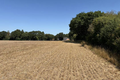
- Price
- From£135,000
Added on 26/08/2026Arable Land