
Land at Rhunahoarine, Tayinloan
- Land size
- 25.83 acres
Key Features
- Exceptional waterfront site
- Extant planning consent for aquaculture uses within an established marine farming location
- Site suitability for redevelopment for leisure use, in a prominent coastal location
- Approximately 25.83 acres (10.45 hectares)
- For sale as whole
Description
Prime coastal development opportunity on Scotland's west coast overlooking the Isles of Islay, Gigha and Jura.
About 25.83 acres (10.45 ha)
For sale as a whole.
Location - The property occupies a prominent coastal headland on the west coast of the Kintyre Peninsula in Argyll & Bute, approximately 2.5 km north of Tayinloan. Situated directly off the A83, it enjoys a spectacular setting with far-reaching views across the Sound of Gigha towards the islands of Gigha, Islay and Jura. The surrounding area is characterised by productive agricultural land, open countryside and an attractive coastline of recognised environmental importance, while remaining well connected to the principal settlements of Tarbert to the north and Campbeltown to the south.
The property lies within a peaceful rural landscape of low-density settlement and grazing land, approximately 16 miles south of Tarbert and 22 miles north of Campbeltown. Set on low-lying coastal ground adjacent to the sea, it benefits from an exceptional Atlantic-facing position within one of Scotland’s most scenic coastal environments.
Access is obtained directly from the A83 Tarbert Road via a single-track hardcore lane, leading to double entrance gates which provide access into the property.
Description - Situated within an area long associated with salmon farming, the property extends to approximately 25.83 acres (10.45 hectares) comprising a former coastal fish farming installation. The predominantly level site has been largely cleared of its former operational structures, creating an attractive development opportunity with considerable scope for redevelopment, subject to planning and statutory approvals.
Located at the centre of the site is a substantial storage building extending to approximately 490 sq m (5,274 sq ft). Constructed of timber under a pitched corrugated sheet roof, the building provides useful storage accommodation. The vendor advises that all asbestos-containing materials have been removed from the site; further information and supporting documentation are available upon request.
The property benefits from extant planning permission under reference 16/03227/PP for the renewal of planning permission 13/02060/PP relating to the redevelopment of the site to accommodate a closed-containment recirculating aquaculture production facility, including staff accommodation, wastewater treatment infrastructure, associated access and parking arrangements, ancillary development works, and demolition of existing structures. The consent presents a significant development opportunity for a new operator to establish a modern aquaculture facility with supporting infrastructure already considered in principle through the planning process.
Development Potential - The land has strong potential for low-density, nature-led tourism development due to its coastal setting, sea views across to Gigha, Islay and Jura, and proximity to the A83 corridor and Tayinloan ferry link.
Suitable alternative uses could include a holiday caravan or lodge park,, ideally designed as a premium coastal retreat.
Other viable options could include a glamping site (pods, cabins, or safari tents), a motorhome touring stopover park, or a boutique holiday village with beach access and nature-based amenities such as walking trails, wildlife viewing areas, or a small marina/boatyard-style leisure facility.
Given the scenic but remote context, developments that emphasise low visual impact, environmental integration, and outdoor recreation (e.g., kayaking, fishing, and wildlife tourism) would likely align best with planning policy in this part of Argyll & Bute.
A more niche alternative could be a wellness or retreat-style development, incorporating cabins or lodges with spa/sauna facilities targeting the “off-grid luxury” market, which is increasingly popular in west coast Scotland. However, all options would need to address access constraints, utilities provision, and coastal planning sensitivity.
Services - The property benefits from a private borehole water supply. A three-phase mains electricity supply previously served the property but has since been disconnected, although the associated infrastructure remains in situ.
Drainage was previously by way of septic tanks, which have since been removed.
Directions - The postcode of the property is PA29 6XG.
what3words: ///possibly.transmits.factored
Local Authority - Argyll and Bute Council
3 Harveys Lane, Burnside Street, Campbeltown, PA28 6GE
Further Information & Viewings - All requests to view the property are to be made via the selling agent in order access can be arranged. All viewings will be accompanied.
Anti-Money Laundering - In accordance with current anti-money laundering regulations, all offers to purchase the property – whether from within the UK or overseas, and whether cash or subject to finance - must be supported by appropriate evidence of source of funds. Acceptable documentation may include a bank statement evidencing the purchase price, a financial reference from a bank or funding provider, or written confirmation from a solicitor verifying that sufficient funds are available to complete the transaction.
Purchasers will also be required to provide certified copies of identification (such as a valid passport) together with proof of residential address, in a form compliant with anti-money laundering legislation.
An administrative fee of £37.50 per person will be charged to cover the cost of the necessary verification checks.
Tenure & Conditions Of Sale - 1. Fixtures & Fittings Items not specifically mentioned within the sale particulars are not included in the sale but may be available for purchase at separate valuation.
2. Title The subjects are sold under the conditions in the Title Deeds, rights of way (if any), water rights affecting the same, whether shown in the Title Deeds or not. They
will be sold as possessed by the Seller and no warranty is given.
3. Deposit On conclusion of missives a deposit of 10 per cent of the purchase price will be paid with the balance due at the date of entry. This deposit will be nonreturnable in the event of a purchaser failing to complete the sale for reasons not attributable to the Sellers or their agent.
Disclaimer Notice - Disclaimer Notice - Please Read: GSC Grays gives notice to anyone who may read these particulars as follows: 1. These particulars, including any plan,
are a general guide only and do not form any part of any offer or contract. 2. All descriptions, including photographs, dimensions and other details are given in good faith but do not amount to our presentation or warranty. This should not be relied upon as statements of facts and anyone interested must satisfy themselves as to their corrections by inspection or otherwise. 3. Neither GSC Grays nor the vendors accept responsibility for any error that these particulars may contain however caused. 4. Any plan is for guidance once only and is not drawn to scale. All dimensions, shapes, and compass bearings are approximate and you should not rely on them without checking them first. 5. Nothing in these particulars shall be deemed to be a statement that the property is in good condition, repair or otherwise nor that any
services or facilities are in good working order. 6. Please discuss with us any aspects that are important to you prior to travelling to the property. Particulars written: September 2026. Photographs taken: May 2026.
Map Location
Property details
- Tenure
- Freehold
- Council Tax Band
- Ask Agent
- Date Posted
- 2026-09-04
Market Value Analysis
Compared with 16 Development Land listings in Scotland (25+ acres).
Utilities & Restrictions
Utilities
- Electricity
- Ask Agent
- Water
- Private Supply
- Heating
- Ask Agent
- Broadband
- Ask Agent
- Sewerage
- Ask Agent
Rights & Restrictions
- Public Rights of Way
- Ask Agent
- Private Rights of Way
- Ask Agent
- Listed Property
- Ask Agent
- Restrictions
- Ask Agent
Listed status, conservation areas and planning constraints for this location are in the full report.
Property Features
- Accessibility
- Ask Agent
- Parking
- Parking Available
- Garden
- Ask Agent
Beyond the particulars: planning activity, flood history, heritage and ground risks, checked for this exact spot.
Connectivity
Broadband
Fastest speed available at this postcode
1.8 Gbps
Gigabit full fibre · available to 13% of premises
Suitable for
- 4K streaming on every screen
- Full-time home working
- Online gaming & big downloads
Mobile signal
Predicted 4G and 5G signal; indoor signal depends on building materials.
Ofcom Connected Nations postcode-level predictions. Speeds and signal are modelled, not measured, and vary between addresses and providers.
Signal is the easy part. Planning activity, flood history and protected designations here are in the full report.
Nearest Schools
Primary
- Rhunahaorine Primary School401 metres
- Pupils
- 13
- Type
- Non-denominational
- Gigha Primary School3.7 miles
- Pupils
- 10
- Type
- Non-denominational
- Clachan Primary School5.9 miles
- Pupils
- 11
- Type
- Non-denominational
- Glenbarr Primary School7.3 miles
- Pupils
- 5
- Type
- Non-denominational
- Carradale Primary School9.1 miles
- Pupils
- 16
- Type
- Non-denominational
Secondary
- Tarbert Academy16 miles
- Pupils
- 120
- Type
- Non-denominational
- Campbeltown Grammar School18 miles
- Pupils
- 380
- Type
- Non-denominational
- Arran High School22 miles
- Pupils
- 242
- Type
- Non-denominational
- Rothesay Academy25 miles
- Pupils
- 277
- Type
- Non-denominational
- Islay High School26 miles
- Pupils
- 191
- Type
- Non-denominational
Distances are straight-line from the advertised location. Source: the national school registers (DfE, Welsh Government, Scottish Government) and Ofsted.
Schools are just the start: planning activity, heritage and any flood history here are in the full report.
Amenities
Supermarket
GP surgery
Pharmacy
Straight-line distances from the advertised location. Sources: NHS records, Geolytix supermarket locations, OS Open Greenspace and the national trails registers.
The area stacks up? Now check the location itself: planning nearby, protected designations and past flooding.
Getting Around
Nearest station
Nearest bus stop
Typical drive times
Straight-line distances from the advertised location; drive times are typical free-flow times over OpenStreetMap road data, so allow more at peak. Public transport locations from DfT NaPTAN.
Easy to reach matters. So do planning activity, flood history and ground risks: all in the full report.
Flood Risk
SEPA open data, checked around the advertised map pin for the listed acreage. Provided by LandSale, not the listing agent, and not part of the agent's particulars. Risk varies across a holding, so verify before committing.
Rivers and the sea
Surface water
Not at the pin: mapped about 10 metres away.
These bandings are the summary. Where this location sits on the flood maps, plus planning activity, heritage and ground risks, is in the full report.
Important notice: Information, maps and tags on this page are drawn from the advertising agent's marketing materials or generated automatically. LandSale has not verified them. Relying on these details is at your own risk, always carry out independent checks before committing to a purchase.
LandSale full disclaimer
Marketing information only - not formal particulars. The details on this website are provided for general guidance and do not constitute an offer or contract. Neither LandSale nor the advertising estate/land agent accepts responsibility for any inaccuracy.
1. Source of information
- Listing content: Core description, asking price, tenure, measurements, photographs and planning history originate from the marketing materials of the advertising estate or land agent. LandSale does not author this content and cannot guarantee its accuracy.
- Automated tags & categorisation: Property type, land-use class, acreage bands and similar labels may be applied by machine-learning models. They are intended as a helpful guide only and may not reflect the property's legal status or permitted use.
- Third-party & enriched data layers: Maps, boundary outlines, planning designations, soil reports, broadband coverage and other environmental or location-based insights are licensed from external suppliers. Such data are supplied “as is", may be incomplete or out of date and are subject to change without notice.
2. Verification required
Prospective purchasers must verify critical matters, including but not limited to planning permission, title boundaries, public rights of way, environmental constraints, acreage, services, access and VAT status, through their own inspections, specialist surveys, legal advisers and the selling agent before relying on the information or entering into any contract.
3. No warranty or liability
LandSale gives no warranty, express or implied, as to the accuracy, completeness or fitness for any particular purpose of the information displayed. LandSale shall not be liable for any loss, damage, cost or expense arising directly or indirectly from any use of or reliance on such information, save where liability may not be excluded by law.
4. Updates & feedback
If you believe any detail on this listing is inaccurate, please let us know. We will investigate and, where appropriate, update the listing or notify the agent.
© LandSale | Version 1.3 - August 2026
Listing agent
GSC Grays, Farm Agency5-6 Bailey Court, Colburn Business Park, Catterick Garrison, DL9 4QL
Contact GSC Grays, Farm Agency
5-6 Bailey Court, Colburn Business Park, Catterick Garrison, DL9 4QL
View agent profileSimilar properties for sale
- Price
- Offers Over£1,500,000
- Size
- 5.21 acres
Added on 20/02/2026Redevelopment Land
- Price
- Guide Price£2,000,000
- Size
- 58.4 acres
Added on 23/09/2026Development Land
- Price
- Guide Price£2,200,000
(COPY of) West Regent Street, City Centre, Glasgow, G2, Glasgow North, Glasgow City G2 Scotland
Added on 29/01/2026Development Land
- Price
- Offers in Region of£1,500,000
Henderson Street, Coatbridge, Motherwell, Wishaw and Carluke, North Lanarkshire ML1 Scotland
Added on 29/01/2026Development Land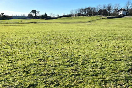
- Price
- Offers Over£1,200,000
- Size
- 17.79 acres
Added on 29/01/2026Development Land