Dunstable Road, Studham, Dunstable, Bedfordshire, LU6
- Land size
- 6.6 acres
- Bedrooms
- 3
- Bathrooms
- 3
Key Features
- Exceptional detached barn conversion extending to approximately 5,000 sq ft
- Private rural smallholding set within approximately 6.6 acres
- Peaceful village location in Studham, on the edge of the Chiltern Hills
- Lawful residential use confirmed by 2025 Lawful Development Certificate
- Outstanding development and redevelopment potential (subject to planning permission)
- Extensive mature grounds with paddocks, woodland and exceptional privacy
- Situated within the village boundary with excellent long-term strategic appeal
- Private driveway with secure access and secluded setting hidden from public view
- Excellent transport links to the M1, London, Harpenden, Berkhamsted and Luton Airport
- Rare opportunity for a private country residence, investment or strategic land acquisition
Description
**An Exceptional Rural Residential Small Holding with Development Potential**
A rare opportunity to acquire a substantial rural holding extending to approximately 6.6 acres, centred around an impressive, detached barn conversion and situated within the highly desirable Bedfordshire village of Studham, on the edge of the Chiltern Hills.
Longyards occupies a private and secluded setting, offering a unique combination of residential accommodation, land ownership and future potential. The principal dwelling comprises a substantial barn-style residence extending to approximately 5,000 sq ft, positioned at the head of a private driveway and surrounded by mature grounds.
The property enjoys a highly attractive rural environment, with open agricultural land lying to the north, paddock land adjoining Dunstable Road to the south, and established residential properties to the east and west. The site is enclosed by mature woodland, established hedgerows and trees, creating an exceptional degree of privacy and screening. As a result, the property is largely hidden from public view and cannot be readily seen from either Dunstable Road or the surrounding countryside.
The current owners sympathetically converted the former agricultural building into a spacious family home, whilst leaving scope for further refurbishment, enhancement and reconfiguration subject to individual requirements. The combination of an established residential use, extensive grounds and strategic location presents a compelling opportunity for purchasers seeking a private country residence with potential for future development opportunities, subject to obtaining the necessary planning consents. Three phase electric is also attached to the house.
Access
The property is accessed via an existing private driveway directly from Dunstable Road, providing convenient and secure access to the site. Longyards lies within the Parish of Studham and benefits from a position within the village boundary, enhancing its long-term appeal and strategic planning context.
Planning History
Historically, the site formed part of a poultry farm operation and benefited from permission for the use of part of the Long Yard barn as an agricultural worker's dwelling under planning reference CB/10/00783/FULL.
The poultry enterprise ceased trading circa 2013, following which the occupiers continued to reside at the property as their principal private residence.
A significant milestone was achieved in August 2025, when Central Bedfordshire Council granted a Lawful Development Certificate (Ref: CB/24/03371/LDCE) for the "Continued Use of a Residential Dwelling". This decision confirms and formally establishes the lawful residential status of the property, providing certainty regarding its residential occupation and creating a strong foundation for future planning considerations.
Development Potential
The site lies within the Metropolitan Green Belt and the Chilterns National Landscape (formerly Area of Outstanding Natural Beauty). Whilst these designations require careful consideration, several factors enhance the site's future prospects.
Key planning strengths include:
• Established lawful residential use confirmed through the recently granted Lawful Development Certificate.
• The presence of a substantial existing residential dwelling.
• A location within the recognised village boundary of Studham.
• Extensive land ownership extending to approximately 6.6 acres.
• Central Bedfordshire Council's acknowledged challenges in maintaining a full five-year housing land supply, which may engage the presumption in favour of sustainable development in accordance with national planning policy.
• Potential opportunities for redevelopment, extension, replacement buildings, ancillary accommodation or other forms of residential-led development, subject to planning permission.
Interested parties should undertake their own planning investigations and seek professional advice regarding any future proposals.
Location & Amenities
Studham is widely regarded as one of Bedfordshire's most sought-after villages, enjoying a picturesque setting within the Chiltern Hills whilst remaining conveniently positioned for access to major employment centres and transport links. The village benefits from a strong community atmosphere, attractive period properties, extensive countryside walks and direct access to some of the region's most beautiful landscapes. [studhampar...cil.gov.uk]
Village Amenities
Studham offers an excellent range of local facilities including:
• Studham Village CE Academy
• Village Hall
• Sports and Social Club
• St Mary's Church
• Methodist Church
• Recreation grounds and open green spaces
• Access to extensive public footpaths, bridleways and countryside walks across the Chilterns National Landscape
• Nearby Dunstable, Harpenden, Berkhamsted and Hemel Hempstead provide an extensive range of shopping, leisure, restaurant, healthcare and employment facilities.
Education
The area is particularly well regarded for its educational offering, with Studham Village CE Academy located within the village and serving younger children. The wider area provides access to a selection of highly regarded state and independent schools including:
• Studham Village CE Academy
• Manshead School, Dunstable
• Ashton St Peter's VA School, Dunstable
• Tring School
• Berkhamsted School
• Beechwood Park School
• St Albans High School for Girls
• St Columba's College, St Albans
Studham Village CE Academy itself enjoys an excellent local reputation and serves children from the village and surrounding area.
Transport Connections
Longyards benefits from excellent accessibility despite its rural setting:
• Dunstable: approximately 5 miles
• Luton: approximately 7 miles
• Hemel Hempstead: approximately 7 miles
• Berkhamsted: approximately 7 miles
• St Albans: approximately 15 miles
• Milton Keynes: approximately 25 miles
• Central London: approximately 35 miles
The property offers convenient access to the M1 motorway (Junctions 9 and 11A), providing connections to London, Milton Keynes and the wider motorway network.
Mainline rail services are available from Harpenden, Luton Parkway, Leagrave and Berkhamsted, offering regular services to London St Pancras and London Euston.
London Luton Airport is located approximately 8 miles away, providing both domestic and international connections.
Summary
Longyards represents a genuinely rare opportunity to acquire a substantial residential holding in one of Bedfordshire's most desirable village locations. Combining a substantial 5,000 sq ft barn conversion, approximately 6.6 acres of private grounds, lawful residential status, exceptional privacy and potential future development prospects, the property offers significant appeal to owner-occupiers, investors and strategic land buyers alike.
Guide purchasers are encouraged to undertake early inspection to fully appreciate the scale, setting and potential of this unique opportunity.
Map Location
Property details
- Tenure
- Freehold
- Council Tax Band
- A
- Date Posted
- 2026-09-01
Market Value Analysis
Compared with 211 Homes with Land listings in East Anglia (5+ acres).
Utilities & Restrictions
Utilities
- Electricity
- Mains
- Water
- Mains
- Heating
- Gas Heating, Oil Heating
- Broadband
- Ask Agent
- Sewerage
- Mains
Rights & Restrictions
- Public Rights of Way
- Ask Agent
- Private Rights of Way
- Ask Agent
- Listed Property
- Ask Agent
- Restrictions
- Ask Agent
Listed status, conservation areas and planning constraints for this location are in the full report.
Property Features
- Accessibility
- Ask Agent
- Parking
- Parking Available
- Garden
- Garden
Beyond the particulars: planning activity, flood history, heritage and ground risks, checked for this exact spot.
Connectivity
Broadband
Fastest speed available at this postcode
1.8 Gbps
Gigabit full fibre
Suitable for
- 4K streaming on every screen
- Full-time home working
- Online gaming & big downloads
Mobile signal
Outdoor predictions; indoor signal depends on building materials.
Ofcom Connected Nations postcode-level predictions. Speeds and signal are modelled, not measured, and vary between addresses and providers.
Signal is the easy part. Planning activity, flood history and protected designations here are in the full report.
Nearest Schools
Primary
- Studham Village CofE Academy793 metresOfsted: Good *
- Ages
- 2 to 9
- Pupils
- 87
- Type
- Academy converter
- Faith
- Church of England
- Kensworth Church of England Academy1.5 milesOfsted report card · Apr 2026
- Ages
- 3 to 11
- Pupils
- 90
- Type
- Academy sponsor led
- Faith
- Church of England
- Dagnall VA Church of England School1.6 milesOfsted: Good
- Ages
- 3 to 11
- Pupils
- 53
- Type
- Voluntary aided school
- Faith
- Church of England
- Markyate Village School and Nursery2.3 milesOfsted: Good *
- Ages
- 4 to 11
- Pupils
- 211
- Type
- Community school
- Little Gaddesden Church of England Voluntary Aided Primary School2.4 milesOfsted: Good *
- Ages
- 3 to 11
- Pupils
- 109
- Type
- Voluntary aided school
- Faith
- Church of England
Secondary
- Manshead Church of England Academy2.8 milesOfsted report card · Feb 2026
- Ages
- 11 to 19
- Pupils
- 1,134
- Type
- Academy sponsor led
- Faith
- Church of England
- Queensbury Academy2.9 milesOfsted: Requires improvement *
- Ages
- 11 to 19
- Pupils
- 1,093
- Type
- Academy sponsor led
- Priory Academy3.3 milesNo Ofsted rating
- Ages
- 9 to 16
- Pupils
- 830
- Type
- Academy converter
- All Saints Academy Dunstable4.1 milesOfsted: Requires improvement *
- Ages
- 11 to 18
- Pupils
- 520
- Type
- Academy sponsor led
- Faith
- Church of England
- The Stockwood Park Academy4.3 milesOfsted: Good *
- Ages
- 11 to 18
- Pupils
- 1,438
- Type
- Academy sponsor led
* Latest graded judgement covers quality of education only; no overall grade was issued under the 2024-25 inspection framework.
Distances are straight-line from the advertised location. Source: the national school registers (DfE, Welsh Government, Scottish Government) and Ofsted.
Schools are just the start: sold prices nearby, planning activity and any flood history are in the full report.
Amenities
Supermarket
GP surgery
Pharmacy
Hospital
Green space
Straight-line distances from the advertised location. Sources: NHS records, Geolytix supermarket locations, OS Open Greenspace and the national trails registers.
The area stacks up? Now check the location itself: planning nearby, protected designations and past flooding.
Getting Around
Nearest station
Nearest bus stop
Typical drive times
Straight-line distances from the advertised location; drive times are typical free-flow times over OpenStreetMap road data, so allow more at peak. Public transport locations from DfT NaPTAN.
Easy to reach matters. So do planning activity, flood history and ground risks: all in the full report.
Flood Risk
From Environment Agency flood map open data, checked around the advertised map pin and allowing for the listed acreage where known. This summary comes from LandSale, the advertising platform, not from the listing agent, and is not part of the agent's particulars. Risk can vary across a single holding, so verify anything critical through your own searches before committing.
Rivers and the sea
Surface water
Mapped within the area searched, not at the advertised map pin itself.
The detail behind these bandings
The full report pinpoints where this location sits on the flood maps, and runs the deeper checks that usually only surface after an offer.
- Exact flood zones & annual chances (included in the full report)
- Any recorded past flooding (included in the full report)
- Planning activity nearby (included in the full report)
- Heritage & conservation (included in the full report)
- Protected nature designations (included in the full report)
- Ground risks (included in the full report)
- Sold prices nearby (included in the full report)
£14.99 · one-off purchase
By LandSale, the platform. Not provided by the listing agent. Ready in about a minute.
Important notice: Information, maps and tags on this page are drawn from the advertising agent's marketing materials or generated automatically. LandSale has not verified them. Relying on these details is at your own risk, always carry out independent checks before committing to a purchase.
LandSale full disclaimer
Marketing information only - not formal particulars. The details on this website are provided for general guidance and do not constitute an offer or contract. Neither LandSale nor the advertising estate/land agent accepts responsibility for any inaccuracy.
1. Source of information
- Listing content: Core description, asking price, tenure, measurements, photographs and planning history originate from the marketing materials of the advertising estate or land agent. LandSale does not author this content and cannot guarantee its accuracy.
- Automated tags & categorisation: Property type, land-use class, acreage bands and similar labels may be applied by machine-learning models. They are intended as a helpful guide only and may not reflect the property's legal status or permitted use.
- Third-party & enriched data layers: Maps, boundary outlines, planning designations, soil reports, broadband coverage and other environmental or location-based insights are licensed from external suppliers. Such data are supplied “as is", may be incomplete or out of date and are subject to change without notice.
2. Verification required
Prospective purchasers must verify critical matters, including but not limited to planning permission, title boundaries, public rights of way, environmental constraints, acreage, services, access and VAT status, through their own inspections, specialist surveys, legal advisers and the selling agent before relying on the information or entering into any contract.
3. No warranty or liability
LandSale gives no warranty, express or implied, as to the accuracy, completeness or fitness for any particular purpose of the information displayed. LandSale shall not be liable for any loss, damage, cost or expense arising directly or indirectly from any use of or reliance on such information, save where liability may not be excluded by law.
4. Updates & feedback
If you believe any detail on this listing is inaccurate, please let us know. We will investigate and, where appropriate, update the listing or notify the agent.
© LandSale | Version 1.3 - August 2026
Listing agent
Taylors Estate Agents, Dunstable
2 High Street South, Dunstable, Bedfordshire, LU6 3HA
Contact Taylors Estate Agents, Dunstable
2 High Street South, Dunstable, Bedfordshire, LU6 3HA
View agent profileSimilar properties for sale
- Price
- £1,550,000
- Size
- 12 acres
Mancroft Road, Luton, Bedfordshire, LU1, Caddington, Central Bedfordshire LU1 England
Added on 18/08/2026House with Land
- Price
- £1,450,000
- Size
- 22 acres
Stable Yard, Mentmore, Buckinghamshire, LU7, Mentmore, Buckinghamshire LU7 England
Added on 14/08/2026Equestrian property
- Price
- Guide Price£2,000,000
- Size
- 7.85 acres
Hawridge Common, Hawridge, HP5, Cholesbury-cum-St Leonards, Buckinghamshire HP5 England
Added on 29/01/2026House with Land
- Price
- Offers in Excess of£1,350,000
- Size
- 6 acres
Flaunden Lane, Bovingdon, HP3, Bovingdon, Hertfordshire HP3 England
Added on 29/01/2026House with Land
- Price
- Guide Price£1,695,000
- Size
- 4 acres
Added on 29/05/2026House with Land
- Price
- £1,500,000
- Size
- 5 acres
Buslins Lane, CHESHAM, Chartridge, Buckinghamshire HP5 England
Added on 06/06/2026House with Land
- Price
- £1,600,000
- Size
- 3 acres
Lower End, Wingrave, Buckinghamshire, HP22, Wingrave with Rowsham, Buckinghamshire HP22 England
Added on 01/05/2026Farmhouse
- Price
- £1,300,000
- Size
- 4.92 acres
Wood End, Tingrith, Bedfordshire, MK17, Tingrith, Central Bedfordshire MK17 England
Added on 08/07/2026House with Land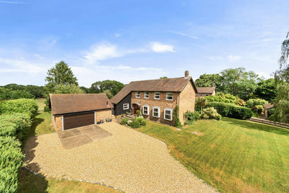
- Price
- Guide Price£1,650,000
- Size
- 4 acres
The Briars, Sarratt, Rickmansworth, WD3, Sarratt, Hertfordshire WD3 England
Added on 13/06/2026House with Land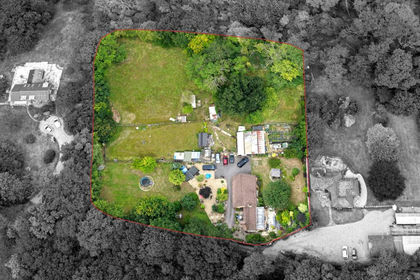
- Price
- Guide Price£1,800,000
- Size
- 3 acres
Templepan Lane, Chandlers Cross, Sarratt, Hertfordshire WD3 England
Added on 29/01/2026House with Land