Newburgh, Cupar, KY14
Key Features
- An exceptional opportunity to acquire one of eight fully serviced self-build plots for impressive detached residences at Jamesfield Farm Steading
- Extending to approximately 2.57 acres
- The development enjoys a notably peaceful rural position a few hundred yards south of the confluence of the River Earn and River Tay.
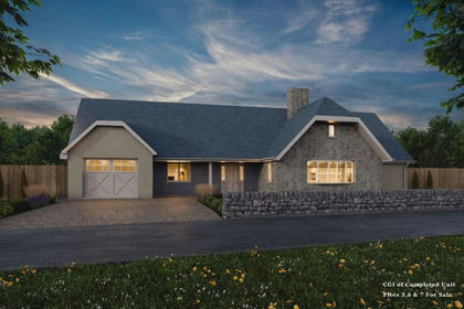
- House Type C, Four Bedroom 1½ Storey Home
Description
A Rare Self-Build Opportunity
Jamesfield Farm Steading represents a compelling opportunity to create a bespoke country home within a carefully considered rural courtyard development, combining privacy, accessibility and strong lifestyle appeal. With services to be installed by the seller and infrastructure works already progressing, purchasers are well placed to focus on design and build. A recommended panel of builders and professional advisers is available if required.
An exceptional opportunity to acquire one of eight fully serviced self-build plots for impressive detached residences at Jamesfield Farm Steading, extending to approximately 2.57 acres (1.04 ha) and arranged in an attractive courtyard setting amid open Perthshire countryside. Set well back from busy public roads, the development enjoys a notably peaceful rural position a few hundred yards south of the confluence of the River Earn and River Tay.
The A903 lies approximately 0.7 miles distant, with Abernethy (2 miles), Newburgh (3 miles), the M90 (Junction 9, 6 miles), Perth (10 miles), Cupar (13 miles), Dundee (21.5 miles), St Andrews (23 miles), Stirling (40 miles) and Edinburgh (44 miles) all readily accessible.
Planning consent (Ref: 16/02074/FLL) has been granted on appeal by Perth and Kinross Council for eight dwellings, with a further three plots (Ref: 24/00064/PREAPL) progressing subject to Section 75 agreement.
Jamesfield Farm Steading occupies a highly desirable rural position within walking distance (approximately 0.6 miles) of the popular Jamesfield restaurant and garden centre via a quiet unclassified public road. The historic conservation village of Abernethy, famed for its round tower, lies 2 miles to the north-east, while the small riverside town of Newburgh is approximately 3 miles distant.
The surrounding area provides excellent opportunities for walking, hacking and outdoor pursuits, including established rights of way through farmland towards Abernethy and scenic routes along the River Earn towards Bridge of Earn. Nearby woodland and river environments support a wide range of activities including cycling, fishing and kayaking. A mainline railway station in Perth offers frequent services to both Edinburgh and Dundee. The offering represents a rare opportunity to acquire not only a building plot but also, by separate negotiation, the option of additional land or paddock, particularly appealing to purchasers with equestrian interests seeking direct hacking from the doorstep.
The Development
The former agricultural shed has now been demolished, with concrete lifted and crushed, part of which has been reused as bottoming for the new perimeter road. Pegging of the individual plots is underway. Following dismantling of the remaining granary, reclaimed stone will be made available to purchasers for incorporation into house wall construction, further enhancing the architectural cohesion of the scheme.
The Sellers will:
Upgrade the access road with additional tarmacadam passing places and form a new perimeter road (subject to Roads Department agreement)
Install mains electricity, private water supply and a private sewage treatment plant with SUDS facilities
Undertake contamination surveys
Provide a bin store adjacent to the public road
Create a children’s play area to the south of the development
Subdivide the courtyard into private garden areas (subject to non-material planning variations), with hedge planting replacing selected stone wall divisions
A residents’ committee will be established to oversee future maintenance of the sewage treatment plant, private water system and communal recreational areas.
There remains flexibility within the wider holding, including potential reconfiguration of the eight-plot scheme to form four larger plots, together with the possibility of additional land acquisition alongside individual lots.
House Types
House Type C, Four Bedroom 1½ Storey Home
House Type C comprises a generous four-bedroom family house arranged over one and a half storeys, thoughtfully designed to reflect traditional Scottish vernacular architecture. Characterised by a steeply pitched slate roof, balanced proportions and a blend of natural stone and smooth rendered finishes and presents a timeless rural aesthetic. The front elevation features a prominent gable with large picture windows maximising natural light to the principal living areas, complemented by a smaller upper dormer adding both character and practical upper-floor accommodation. An integrated double garage with traditional-style doors and gravel driveway provides modern convenience, while the recessed entrance offers a sheltered and welcoming approach.
Internally, the layout provides adaptable accommodation with bedrooms arranged across both ground and upper levels, ideal for growing families or flexible home working. Externally, low natural stone boundary walls, private garden ground and open countryside views allow the property to sit comfortably within the courtyard while maintaining a strong landscape connection.
Available Plots:
Lot 4 (Type C) Offers Over £95,000
Lot 5 (Type C) Offers Over £95,000
Lot 1 (Type C) Offers Over £95,000
Plot sizes range from approximately 0.18 to 0.27 acres.
Additional Land
There is the opportunity, by separate negotiation, to purchase a house plot together with additional land or paddock, ideal for those with equestrian or smallholding interests.
Owners and Professional Team
Owners: Ian & Roy Miller
Architect / Planning: WJ Beatson Planning
Planning Reference: 16/02074/FLL (granted on appeal).
The Section 75 Agreement has been signed, requiring the sellers to meet low-cost housing, road and education contributions.
Directions From Edinburgh:
Cross the Forth Road Bridge and join the M90 northbound signposted Perth, Dundee and Aberdeen. Exit at Junction 9 and turn right onto
the A912 signposted Newburgh and Cupar. At the roundabout take the first exit onto the A913 and proceed through Abernethy. Approximately one mile beyond the village, immediately after the traffic lights at the narrow railway bridge, turn first left. Continue past the farm restaurant and nursery, descend the hill and take the first right onto a tarmacadam farm road. Proceed past the farmhouse bungalow; the steading lies approximately 200 yards further along.
Directions From Dundee:
Cross the Tay Bridge and at the roundabout take the second exit onto the A92 signposted Edinburgh and Kirkcaldy. At the Forgan roundabout take the second exit onto the A92, then turn right onto the A913. Continue past Newburgh, then turn right and right again, following signs to Jamesfield Farm.
Important Notice
These particulars do not form part of any offer or contract. All measurements are approximate and provided for guidance only. No responsibility can be accepted for any errors, omissions or mis-statements.
Map Location
Property details
- Tenure
- Freehold
- Council Tax Band
- Ask Agent
- Date Posted
- 2026-08-28
Utilities & Restrictions
Utilities
- Electricity
- Ask Agent
- Water
- Ask Agent
- Heating
- Ask Agent
- Broadband
- Ask Agent
- Sewerage
- Ask Agent
Rights & Restrictions
- Public Rights of Way
- Ask Agent
- Private Rights of Way
- Ask Agent
- Listed Property
- Ask Agent
- Restrictions
- Ask Agent
Listed status, conservation areas and planning constraints for this location are in the full report.
Property Features
- Accessibility
- Ask Agent
- Parking
- Parking Available
- Garden
- Garden
Beyond the particulars: planning activity, flood history, heritage and ground risks, checked for this exact spot.
Connectivity
Broadband
Fastest speed available at this postcode
1.8 Gbps
Gigabit full fibre
Suitable for
- 4K streaming on every screen
- Full-time home working
- Online gaming & big downloads
Mobile signal
Predicted 4G and 5G signal; indoor signal depends on building materials.
Ofcom Connected Nations postcode-level predictions. Speeds and signal are modelled, not measured, and vary between addresses and providers.
Signal is the easy part. Planning activity, flood history and protected designations here are in the full report.
Nearest Schools
Primary
- Abernethy Primary School1 mile
- Pupils
- 129
- Type
- Non-denominational
- St Madoes Primary School1.9 miles
- Pupils
- 113
- Type
- Non-denominational
- Newburgh Primary School2.6 miles
- Pupils
- 128
- Type
- Non-denominational
- Dunbarney Primary School4.2 miles
- Pupils
- 203
- Type
- Non-denominational
- Auchtermuchty Primary School4.5 miles
- Pupils
- 139
- Type
- Non-denominational
Secondary
- Perth Academy6.8 miles
- Pupils
- 1,011
- Type
- Non-denominational
- St John's RC Academy6.9 miles
- Pupils
- 641
- Type
- Roman Catholic
- Perth Grammar School7.1 miles
- Pupils
- 728
- Type
- Non-denominational
- Perth High School7.2 miles
- Pupils
- 1,487
- Type
- Non-denominational
- Bertha Park High School8.8 miles
- Pupils
- 645
- Type
- Non-denominational
Distances are straight-line from the advertised location. Source: the national school registers (DfE, Welsh Government, Scottish Government) and Ofsted.
Schools are just the start: planning activity, heritage and any flood history here are in the full report.
Amenities
Supermarket
GP surgery
Pharmacy
Walking trail
Straight-line distances from the advertised location. Sources: NHS records, Geolytix supermarket locations, OS Open Greenspace and the national trails registers.
The area stacks up? Now check the location itself: planning nearby, protected designations and past flooding.
Getting Around
Nearest station
Nearest bus stop
Typical drive times
Straight-line distances from the advertised location; drive times are typical free-flow times over OpenStreetMap road data, so allow more at peak. Public transport locations from DfT NaPTAN.
Easy to reach matters. So do planning activity, flood history and ground risks: all in the full report.
Flood Risk
SEPA open data, checked around the advertised map pin for the listed acreage. The map pin for this listing marks the postcode area rather than the exact location, so these readings describe the surrounding area. Provided by LandSale, not the listing agent, and not part of the agent's particulars. Risk varies across a holding, so verify before committing.
Rivers and the sea
Surface water
Not at the pin: mapped about 20 metres away.
These bandings are the summary. Where this location sits on the flood maps, plus planning activity, heritage and ground risks, is in the full report.
Important notice: Information, maps and tags on this page are drawn from the advertising agent's marketing materials or generated automatically. LandSale has not verified them. Relying on these details is at your own risk, always carry out independent checks before committing to a purchase.
LandSale full disclaimer
Marketing information only - not formal particulars. The details on this website are provided for general guidance and do not constitute an offer or contract. Neither LandSale nor the advertising estate/land agent accepts responsibility for any inaccuracy.
1. Source of information
- Listing content: Core description, asking price, tenure, measurements, photographs and planning history originate from the marketing materials of the advertising estate or land agent. LandSale does not author this content and cannot guarantee its accuracy.
- Automated tags & categorisation: Property type, land-use class, acreage bands and similar labels may be applied by machine-learning models. They are intended as a helpful guide only and may not reflect the property's legal status or permitted use.
- Third-party & enriched data layers: Maps, boundary outlines, planning designations, soil reports, broadband coverage and other environmental or location-based insights are licensed from external suppliers. Such data are supplied “as is", may be incomplete or out of date and are subject to change without notice.
2. Verification required
Prospective purchasers must verify critical matters, including but not limited to planning permission, title boundaries, public rights of way, environmental constraints, acreage, services, access and VAT status, through their own inspections, specialist surveys, legal advisers and the selling agent before relying on the information or entering into any contract.
3. No warranty or liability
LandSale gives no warranty, express or implied, as to the accuracy, completeness or fitness for any particular purpose of the information displayed. LandSale shall not be liable for any loss, damage, cost or expense arising directly or indirectly from any use of or reliance on such information, save where liability may not be excluded by law.
4. Updates & feedback
If you believe any detail on this listing is inaccurate, please let us know. We will investigate and, where appropriate, update the listing or notify the agent.
© LandSale | Version 1.3 - August 2026
Listing agent
Watermans, Edinburgh
5-10 Dock Place Edinburgh EH6 6LU
Similar properties for sale
- Price
- Offers Over£95,000
- Size
- 0.23 acres
Newburgh, Cupar, KY14, Perth and Kinross-shire, Perth and Kinross KY14 Scotland
Added on 28/08/2026Self Build Plot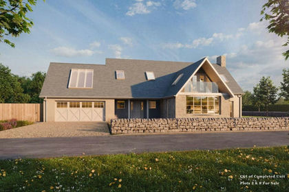
- Price
- Offers Over£95,000
- Size
- 0.27 acres
Newburgh, Cupar, KY14, Perth and Kinross-shire, Perth and Kinross PH2 Scotland
Added on 28/08/2026Self Build Plot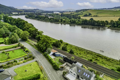
- Price
- Offers Over£120,000
- Size
- 0.17 acres
Added on 08/10/2026Building Plot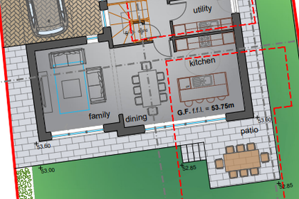
- Price
- Offers Over£75,000
18 Low Road, Auchtermuchty KY14, North East Fife, Fife KY14 Scotland
Added on 29/01/2026Self Build Plot
- Price
- Guide Price£76,000
Building Plot, Muirhall Road, Perth, PH2, Perth and Kinross-shire, Perth and Kinross PH2 Scotland
Added on 14/07/2026Building Plot
- Price
- Offers in Region of£95,000
Added on 15/05/2026Building Plot
- Price
- Guide Price£120,000
- Size
- 0.36 acres
Added on 04/06/2026Building Plot
- Price
- Offers Over£69,500
- Size
- 0.21 acres
West Tofts, Stanley, PH1, Angus and Perthshire Glens, Perth and Kinross PH1 Scotland
Added on 18/06/2026Self Build Plot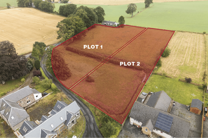
- Price
- Offers Over£85,000
Woodside, Burrelton, Blairgowrie, PH13, Angus and Perthshire Glens, Perth and Kinross PH13 Scotland
Added on 01/09/2026Self Build Plot