Lot 2: Lawrence Farm, Moor Lane, Wincanton, Somerset, BA9
- Land size
- 20.71 acres
Description
Lawrence Farm, Moor Lane, Wincanton, Somerset, BA9 9EJ
A 75-acre livestock and residential farm.
Lawrence Farm comprises an accessible livestock farm serviced by a detached farmhouse for modernisation, together with a range of livestock buildings and surrounding pastureland.
In all extending to 75.09 acres.
For sale by online auction in up to four separate lots.
Location
Lawrence Farm is located a short distance to the south of the Somerset town of Wincanton and the A303 with access from Moor Lane.
Wincanton provides a good range of local facilities including retail, leisure and schooling. The nearby vibrant town of Bruton, which is about 6 miles to the north, provides a further range of facilities including the Hauser and Wirth Art Gallery and King’s School Bruton.
Castle Cary offers further independent shops, whilst the Newt on the outskirts of the town offers a boutique hotel and restaurant and wonderful gardens. Gillingham and Sherborne are also within easy reach of Lawrence Farm.
The property benefits from excellent communications with the nearby A303 together with mainline rail services from Castle Cary (about 8 miles away) to London Paddington, and Gillingham (also about 8 miles away) to London Waterloo.
Lot 1 (blue on the site plan):
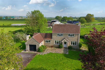
Lawrence Farmhouse within 6.26 acres.
The property comprises a three bedroom detached dwelling offering accommodation of 1,309sqft (121.6sqm) (including the garage/storage room).
The accommodation comprises:
Sitting room
Dining room
Kitchen
Utility room with WC off
Garage/storage room
Two double bedrooms
One single bedroom
Family bathroom
Outside
The property benefits from a lawned garden with hedgerow boundaries and a large parking area. The farmhouse and curtilage extends to 0.30 of an acre.
It should be noted that the doors and windows have been boarded up for security reasons as the property is currently vacant.
Adjoining the garden is a pasture field extending to 5.96 acres. The western boundary comprises the middle of the River Cale. Access is available along the southern boundary of this field. Access rights will be granted over the driveway to the existing gateway into this field.
In all, Lot 1 extends to 6.26 acres. The purchaser of Lot 1 will be granted an option to purchase Lot 2, as described below.
Lot 2 (yellow on the site plan): Lawrence Farm Buildings within 20.71 acres
The farm buildings comprise a range of livestock and storage buildings situated to the south of the farmhouse described as follows:
1. Block and fibre cement former cowstalls with lean-to off.
2. Steel framed former dairy and parlour.
3. Dutch barn with lean-to stores off.
4. Pole barn.
5. Pole barn.
6. Timber and steel cow kennel housing.
7. Covered silage clamp/loose housing building with adjoining storage area.
8. Former slurry lagoon with earth bank walls.
9. Above ground slurry store.
Surrounding the farm buildings are four pasture enclosures and a small copse offered together with the buildings. The two larger fields adjoin Moor Lane along their northern boundary and benefit from direct road access. In addition, there are two pasture paddocks to the south of the buildings with access via the buildings, together with a small copse. In all, Lot 2 extends to 20.71 acres.
The Land - Lots 3 and 4
Lot 3 (orange on the site plan): 31.57 acres of pasture
Lot 3 comprises the land to the south of the farm buildings. Access is available from the adjoining farm drive. In all, Lot 3 extends to 31.57 acres.
Lot 4 (green on the site plan): 16.55 acres of pasture
Lot 4 comprises the pastureland north of the Wessex Water Treatment Works. Access is available from the adjoining farm drive/via the track to the south of this lot. Potential purchasers should satisfy themselves of the position of the boundaries of this lot, as they are not fenced from the adjoining third party land, with the land grazed as one with this land. In all, Lot 4 extends to 16.55 acres.
Method of Sale
The property is offered for sale by online auction with guide prices* for the individual lots as listed below. The property will be sold subject to a reserve price**. For further information, to register to bid, and review the auction packs, visit carterjonas.co.uk/property-auctions.
*The guide price is an indication of the range within which or, in the case of single figure guide prices, within ten percent of which, the minimum sale price will fall.
**The reserve price is the minimum price at which the auctioneer is authorised by the seller to sell the lot at auction. The lot may be sold to the highest bidder at or above the reserve price, but the auctioneer is not authorised to sell at a figure below the reserve price. Both the guide price and the reserve price are subject to change. Potential purchasers should ensure that they register their interest in the property and regularly check for updated information regarding the property, including changes to the guide price.
The guide price for the whole is £1,340,000.
The guide price for Lot 1 is £475,000.
The guide price for Lot 2 is £385,000.
The guide price for Lot 3 is £315,000.
The guide price for Lot 4 is £165,000.
The whole will be offered for sale first with an auction finish time of midday on Thursday 1st October 2026. If the property does not sell as a whole, then Lot 1 will be offered with an auction finish time of midday on Thursday 8th October 2026. The successful purchaser of Lot 1 will be offered the option to purchase Lot 2 for the guide price of £385,000. If the purchaser of Lot 1 does not opt to purchase Lot 2, Lot 2 will then be offered for sale with an auction finish time of midday on Thursday 22nd October 2026. Lot 3 will be offered for sale with an auction finish time of 1400 on 22nd October 2026. Lot 4 will be offered for sale with an auction finish time of 1600 on 22nd October 2026. Completion of the sale of all four lots is due on 19th November 2026.
Tenure & Possession
The freehold of the property is offered for sale with vacant possession available upon completion.
Covenants
Lawrence Farmhouse will be sold subject to a covenant to use the property as a single dwelling house and for associated ancillary purposes only. The land within Lot 1 outside of the farmhouse garden area will be sold subject to a covenant to use this for agricultural, equestrian, horticultural, and/or forestry purposes.
Lots 2 – 4 comprising the farm buildings and agricultural land will be sold subject to a covenant to use the property for agricultural, equestrian, horticultural and/or forestry purposes.
Public Rights of Way
There is a public footpath running through the property.
Services
The farmhouse is serviced by mains water, drainage, and electricity. The water supply to the farmhouse currently services the farm buildings. If Lots 1 and 2 are sold separately, then this supply will be sold with Lot 1 and the purchaser of Lot 2 will not have a right to use this supply. The land lots will be sold with a right to install their own connections over Lot 2.
Health & Safety
Potential purchasers should take particular care when inspecting the property, bearing in mind especially the risk of sudden movements from livestock, machinery, and vehicles which may be present and operating at the time of inspection, particularly in and around the farm buildings. Potential purchasers are requested to wear supportive footwear for viewings and are advised to be conscious of potentially uneven and slippery ground surfaces.
EPC Rating
Lawrence Farmhouse has a current EPC rating of E.
Local Authority
Somerset Council
Viewings
Viewings are accompanied by the vendor’s agents, Carter Jonas, on .
Directions
From the A303 Wincanton turning, follow signs towards Wincanton town centre. Continue straight on at the roundabout by Morrisons and Lidl supermarkets. At the mini-rounadbout turn right (third exit) signed Maddocks Pavillion. Follow Moor Lane, passing under the A303, and the entrance to Lawrence Farm will found on the right-hand side after the electricity substation.
What Three Words
/// digs.manages.disbelief
Map Location
Property details
- Tenure
- Freehold
- Council Tax Band
- TBC
- Date Posted
- 2026-08-25
Market Value Analysis
Compared with 84 Farms & Smallholdings listings in South West England (10+ acres).
Utilities & Restrictions
Utilities
- Electricity
- Ask Agent
- Water
- Ask Agent
- Heating
- Ask Agent
- Broadband
- Ask Agent
- Sewerage
- Ask Agent
Rights & Restrictions
- Public Rights of Way
- Ask Agent
- Private Rights of Way
- Ask Agent
- Listed Property
- Ask Agent
- Restrictions
- Ask Agent
Listed status, conservation areas and planning constraints for this location are in the full report.
Property Features
- Accessibility
- Ask Agent
- Parking
- Parking Available
- Garden
- Garden
Beyond the particulars: planning activity, flood history, heritage and ground risks, checked for this exact spot.
Connectivity
Broadband
Fastest speed available at this postcode
1 Gbps
Gigabit full fibre
Suitable for
- 4K streaming on every screen
- Full-time home working
- Online gaming & big downloads
Mobile signal
Outdoor predictions; indoor signal depends on building materials.
Ofcom Connected Nations postcode-level predictions. Speeds and signal are modelled, not measured, and vary between addresses and providers.
Signal is the easy part. Planning activity, flood history and protected designations here are in the full report.
Nearest Schools
Primary
- Wincanton Primary School670 metresOfsted: Good
- Ages
- 4 to 11
- Pupils
- 388
- Type
- Community school
- Our Lady of Mount Carmel Catholic Primary905 metresOfsted: Requires improvement *
- Ages
- 4 to 11
- Pupils
- 107
- Type
- Academy converter
- Faith
- Roman Catholic
- Horsington Church School2.2 milesNo Ofsted rating
- Ages
- 4 to 11
- Pupils
- 93
- Type
- Academy converter
- Faith
- Church of England
- Abbas and Templecombe Church School3.1 milesNo Ofsted rating
- Ages
- 4 to 11
- Pupils
- 109
- Type
- Academy converter
- Faith
- Church of England
- St George's Church of England School, Bourton3.8 milesOfsted: Good *
- Ages
- 2 to 11
- Pupils
- 142
- Type
- Academy converter
- Faith
- Church of England
Secondary
- King Arthur's School0.8 milesOfsted: Requires improvement *
- Ages
- 11 to 16
- Pupils
- 450
- Type
- Academy sponsor led
- Sexey's School4.6 milesOfsted: Good
- Ages
- 11 to 18
- Pupils
- 633
- Type
- Academy converter
- Faith
- Church of England
- Ansford Academy5.6 milesOfsted report card · Feb 2026
- Ages
- 11 to 16
- Pupils
- 469
- Type
- Academy converter
- Gillingham School6.2 milesOfsted: Good
- Ages
- 11 to 18
- Pupils
- 1,684
- Type
- Voluntary controlled school
- The Gryphon School7.7 milesNo Ofsted rating
- Ages
- 11 to 18
- Pupils
- 1,569
- Type
- Academy converter
- Faith
- Church of England
* Latest graded judgement covers quality of education only; no overall grade was issued under the 2024-25 inspection framework.
Distances are straight-line from the advertised location. Source: the national school registers (DfE, Welsh Government, Scottish Government) and Ofsted.
Schools are just the start: sold prices nearby, planning activity and any flood history are in the full report.
Amenities
Supermarket
GP surgery
Pharmacy
Hospital
Green space
Straight-line distances from the advertised location. Sources: NHS records, Geolytix supermarket locations, OS Open Greenspace and the national trails registers.
The area stacks up? Now check the location itself: planning nearby, protected designations and past flooding.
Getting Around
Nearest station
Nearest bus stop
Typical drive times
Straight-line distances from the advertised location; drive times are typical free-flow times over OpenStreetMap road data, so allow more at peak. Public transport locations from DfT NaPTAN.
Easy to reach matters. So do planning activity, flood history and ground risks: all in the full report.
Flood Risk
From Environment Agency flood map open data, checked around the advertised map pin and allowing for the listed acreage where known. This summary comes from LandSale, the advertising platform, not from the listing agent, and is not part of the agent's particulars. Risk can vary across a single holding, so verify anything critical through your own searches before committing.
Rivers and the sea
Surface water
Mapped within the area searched, not at the advertised map pin itself.
The detail behind these bandings
The full report pinpoints where this location sits on the flood maps, and runs the deeper checks that usually only surface after an offer.
- Exact flood zones & annual chances (included in the full report)
- Any recorded past flooding (included in the full report)
- Planning activity nearby (included in the full report)
- Heritage & conservation (included in the full report)
- Protected nature designations (included in the full report)
- Ground risks (included in the full report)
- Sold prices nearby (included in the full report)
£14.99 · one-off purchase
By LandSale, the platform. Not provided by the listing agent. Ready in about a minute.
Important notice: Information, maps and tags on this page are drawn from the advertising agent's marketing materials or generated automatically. LandSale has not verified them. Relying on these details is at your own risk, always carry out independent checks before committing to a purchase.
LandSale full disclaimer
Marketing information only - not formal particulars. The details on this website are provided for general guidance and do not constitute an offer or contract. Neither LandSale nor the advertising estate/land agent accepts responsibility for any inaccuracy.
1. Source of information
- Listing content: Core description, asking price, tenure, measurements, photographs and planning history originate from the marketing materials of the advertising estate or land agent. LandSale does not author this content and cannot guarantee its accuracy.
- Automated tags & categorisation: Property type, land-use class, acreage bands and similar labels may be applied by machine-learning models. They are intended as a helpful guide only and may not reflect the property's legal status or permitted use.
- Third-party & enriched data layers: Maps, boundary outlines, planning designations, soil reports, broadband coverage and other environmental or location-based insights are licensed from external suppliers. Such data are supplied “as is", may be incomplete or out of date and are subject to change without notice.
2. Verification required
Prospective purchasers must verify critical matters, including but not limited to planning permission, title boundaries, public rights of way, environmental constraints, acreage, services, access and VAT status, through their own inspections, specialist surveys, legal advisers and the selling agent before relying on the information or entering into any contract.
3. No warranty or liability
LandSale gives no warranty, express or implied, as to the accuracy, completeness or fitness for any particular purpose of the information displayed. LandSale shall not be liable for any loss, damage, cost or expense arising directly or indirectly from any use of or reliance on such information, save where liability may not be excluded by law.
4. Updates & feedback
If you believe any detail on this listing is inaccurate, please let us know. We will investigate and, where appropriate, update the listing or notify the agent.
© LandSale | Version 1.3 - August 2026
Listing agent
Carter Jonas Rural, Taunton
The Quad, Blackbrook Park Avenue, Taunton, TA1 2PX
Contact Carter Jonas Rural, Taunton
The Quad, Blackbrook Park Avenue, Taunton, TA1 2PX
View agent profileSimilar properties for sale
- Price
- Guide Price£475,000
- Size
- 6.26 acres
Lot 1: Lawrence Farm, Moor Lane, Wincanton, Somerset, BA9, Wincanton, Somerset BA9 England
Added on 25/08/2026House with Land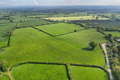
- Price
- Guide Price£315,000
- Size
- 31.57 acres
Lot 3: Lawrence Farm, Moor Lane, Wincanton, Somerset, BA9, Wincanton, Somerset BA9 England
Added on 25/08/2026Pasture
- Price
- £500,000
- Size
- 4 acres
., Riding Gate, WINCANTON, Stoke Trister, Somerset BA9 England
Added on 31/07/2026House with Land
- Price
- Guide Price£400,000
- Size
- 1.1 acres
Lower Road, South Cheriton, Templecombe, Horsington, Somerset BA8 England
Added on 13/02/2026Development Land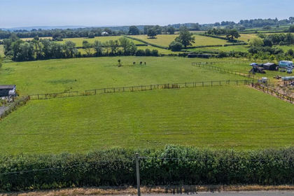
- Price
- Guide Price£250,000
- Size
- 0.33 acres
Cabbage Lane, Horsington, Templecombe, Horsington, Somerset BA8 England
Added on 04/07/2026Building Plot- Price
- Guide Price£250,000
- Size
- 0.33 acres
Cabbage Lane, Horsington, Templecombe, Horsington, Somerset BA8 England
Added on 04/07/2026Building Plot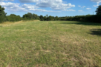
- Price
- Guide Price£350,000
- Size
- 1.5 acres
Whitechurch Lane, Yenston, Henstridge, Henstridge, Somerset BA8 England
Added on 06/05/2026Self Build Plot
- Price
- Guide Price£475,000
Charlton Horethorne, Sherborne, Somerset, Charlton Horethorne, Somerset DT9 England
Added on 04/02/2026Barn Conversion
- Price
- Guide Price£240,000
Cary Road, Yeovil, BA22, North Cadbury, Somerset BA22 England
Added on 02/07/2026Barn Conversion Added on 22/07/2026Barn Conversion