Holton Road, Wenhaston With Mells Hamlet, Suffolk
- Land size
- 1.21 acres
- Use Class
- Use Class: C3
Key Features
- Residential development opportunity
- Positive pre-application advice from East Suffolk Council
- Officers minded to support residential development in principle
- Indicative scheme for five new dwellings
- Approximately 753 sq m / 8,105 sq ft of indicative residential accommodation
- Site extending to approximately 1.21 acres / 0.49 hectares
- Purchaser able to promote their own preferred scheme, subject to agreement
- For sale subject to satisfactory planning permission
- For sale subject to satisfactory planning permission
- Superb far-reaching countryside views
Description
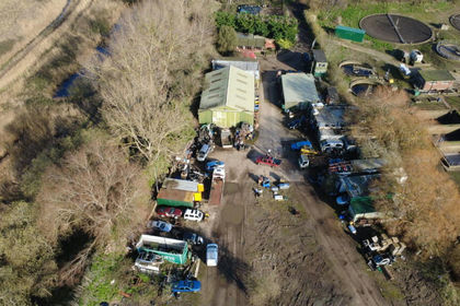
An exciting opportunity to acquire a residential development site extending to approximately 1.21 acres (0.49 hectares) at Highfield Farm, Holton Road, Mells, near Halesworth.
Occupying an attractive rural position, the site is approached via a long private driveway and enjoys an impressive countryside setting, with far-reaching views across the surrounding rolling landscape, mature trees and open farmland.
The property is being offered for sale subject to planning permission, providing a purchaser or developer with the opportunity to prepare and promote their own preferred scheme, subject to agreement with the vendor.
Planning Potential
Importantly, the site benefits from positive pre-application advice from East Suffolk Council for the demolition of the existing agricultural buildings and the development of five new dwellings, utilising an in-principle Class Q fallback position.
The planning history and subsequent discussions with East Suffolk Council provide a particularly useful foundation for a purchaser considering the site.
The Council has previously confirmed that Barn 1 would likely be acceptable for conversion under Class Q, subject to the other relevant barns being demolished and the necessary supporting evidence being provided. The Council also accepted that a Class Q fallback could exist and indicated that appropriately designed new-build dwellings could represent an enhancement over conversion of the existing agricultural building.
This position was subsequently considered through a formal pre-application enquiry.
In its written response, East Suffolk Council advised that, subject to satisfactorily evidencing the Class Q fallback position, five dwellings providing approximately 750 sq m of accommodation represented a realistic quantum of development and would not appear to constitute overdevelopment when compared with the buildings being replaced.
Significantly, the Council concluded that officers were minded to support new residential development on the site in principle, subject to the proposed development providing a material betterment over what could otherwise be delivered through Class Q conversions.
The indicative scheme adopts the character of an evolved traditional farm complex rather than a conventional housing estate. The submitted elevations illustrate a combination of a larger farmhouse-style dwelling and lower, predominantly single-storey barn-inspired homes.
The Council considered the general indicative layout broadly acceptable, subject to the detailed matters that would ordinarily accompany a full planning application.
Indicative Development
The current concept provides for five new homes with a combined indicative floor area of approximately 753 sq m (8,105 sq ft):
- Plot 1: approximately 272 sq m
- Plot 2: approximately 116 sq m
- Plot 3: approximately 116 sq m
- Plot 4: approximately 103 sq m
- Plot 5: approximately 146 sq m
These plans are indicative only and are intended to demonstrate the development potential of the site. A purchaser or developer may prepare and promote their own preferred design and planning strategy, subject to the vendor's approval and the terms of the agreed conditional contract, option agreement or other subject-to-planning arrangement.
The Site
Highfield Farm offers a setting that is difficult to replicate. The long approach creates a sense of arrival and separation from Holton Road, opening into a substantial former agricultural complex surrounded by countryside.
The site's elevated rural surroundings, mature trees and undulating landscape provide an attractive backdrop for a sensitively designed residential scheme and lend themselves particularly well to the farmstead-style approach discussed with the Local Planning Authority.
The pre-application response also confirms that the site lies within Flood Zone 1, with no identified surface-water flood risk on the site, and that there are no heritage assets identified as being affected by the proposal.
The existing access from Holton Road is proposed to serve the development, subject to demonstrating appropriate visibility splays and the usual consultation with Suffolk County Council Highways. The Council's pre-application advice also indicates that there appears to be sufficient space within the site to accommodate the required parking.
Method of Sale
The site is offered subject to contract and subject to satisfactory planning permission.
The anticipated transaction structure is an option agreement, conditional contract or similar subject-to-planning arrangement, enabling the purchaser to undertake the planning process before completion of the acquisition. Unless otherwise agreed, the purchaser will be responsible for preparing, funding and managing their planning application, professional advice, technical due diligence and associated planning costs.
Location
Highfield Farm occupies an attractive rural position at Mells, immediately east of the popular market town of Halesworth, combining an open countryside setting with convenient access to everyday amenities. Mells forms part of the parish of Wenhaston with Mells Hamlet and sits on the southern side of the River Blyth.
The surrounding landscape is a significant part of the site's appeal. The wider parish is characterised by open countryside, mature trees, commons, heathland and farmland and lies between Halesworth and the Suffolk Coast, with the nationally recognised landscapes around the Suffolk Coast and Heaths forming part of the wider setting.
Despite its rural position, the site is particularly well placed for Halesworth, approximately one mile to the west, while the highly desirable coastal town of Southwold is approximately six miles away. Beccles is approximately nine miles away, providing further shopping, schooling and leisure facilities.
Halesworth & Local Amenities
Halesworth is an attractive and established Suffolk market town serving a substantial rural catchment. The town had a population of approximately 4,900 at the 2021 Census, while research commissioned by Halesworth Town Council identified a population of approximately 10,000 across Halesworth and its surrounding parishes, demonstrating the wider population served by the town.
The town provides an excellent range of independent shops, cafés, public houses, professional services and everyday facilities centred around the historic Thoroughfare and Market Place. Amenities include Central Co-op Food, Cafe & Petrol - Halesworth, local convenience stores and Halesworth Market, together with primary education at Edgar Sewter Primary School.
An important attraction for purchasers is the availability of rail connections from Halesworth Station, with the town situated on the East Suffolk Line between Ipswich and Lowestoft. This allows the development to offer countryside living without being entirely dependent upon road travel.
The location also benefits from its proximity to the Suffolk Heritage Coast and Southwold, considerably broadening its lifestyle appeal. Wenhaston itself is around 8 km west of the coast, and the wider area is noted for its commons, walking routes, countryside and proximity to the Suffolk Coast and Heaths landscape.
Development Appeal
From a development perspective, Highfield Farm offers an appealing combination: a genuinely rural setting and substantial countryside views, yet within very easy reach of an established market town and the Suffolk coast.
The long approach to the site, surrounding rolling countryside and mature landscape create the opportunity for a distinctive development with a strong sense of place. This is particularly well suited to the farmstead-style scheme encouraged through the pre-application process, rather than a conventional suburban housing layout.
The local demographic and housing profile also reflects the area's established residential character. Wenhaston with Mells is predominantly rural, with development concentrated around Wenhaston, Blackheath and smaller clusters including Mells. The wider Halesworth area provides the services and population catchment to complement that rural environment, while its proximity to Southwold and the Suffolk coast adds an additional premium lifestyle element.
For a developer, the opportunity therefore has the potential to appeal to several purchaser markets, including local families, downsizers seeking high-quality single-storey accommodation, buyers relocating to Suffolk and purchasers looking for countryside living within easy reach of Halesworth and the coast.
Jamie - VAT Login
User ID:
Password: McD0nald!$$
Map Location
Property details
- Tenure
- Freehold
- Council Tax Band
- Ask Agent
- Date Posted
- 2026-08-21
Market Value Analysis
Compared with 158 Development Land listings in East Anglia (1+ acres).
Utilities & Restrictions
Utilities
- Electricity
- Ask Agent
- Water
- Ask Agent
- Heating
- Ask Agent
- Broadband
- Ask Agent
- Sewerage
- Ask Agent
Rights & Restrictions
- Public Rights of Way
- Ask Agent
- Private Rights of Way
- Ask Agent
- Listed Property
- Ask Agent
- Restrictions
- Ask Agent
Property Features
- Accessibility
- Ask Agent
- Parking
- Ask Agent
- Garden
- Ask Agent
Connectivity
Broadband
Fastest speed available at this postcode
1.8 Gbps
Gigabit full fibre · available to 80% of premises
Suitable for
- 4K streaming on every screen
- Full-time home working
- Online gaming & big downloads
Mobile signal
Outdoor predictions; indoor signal depends on building materials.
Ofcom Connected Nations postcode-level predictions. Speeds and signal are modelled, not measured, and vary between addresses and providers.
Nearest Schools
Primary
- Holton St Peter Community Primary School0.7 milesOfsted report card · Jan 2026
- Ages
- 3 to 11
- Pupils
- 141
- Type
- Academy converter
- Edgar Sewter Community Primary School1.3 milesOfsted: Good
- Ages
- 3 to 11
- Pupils
- 266
- Type
- Academy converter
- Wenhaston Primary School1.6 milesOfsted: Good
- Ages
- 4 to 11
- Pupils
- 93
- Type
- Academy converter
- Bramfield Church of England Primary School1.8 milesNo Ofsted rating
- Ages
- 4 to 11
- Pupils
- 103
- Type
- Academy sponsor led
- Faith
- Church of England
- Brampton Church of England Primary School4.1 milesOfsted report card · Feb 2026
- Ages
- 4 to 11
- Pupils
- 82
- Type
- Academy sponsor led
- Faith
- Church of England
Secondary
- Sir John Leman High School8.1 milesOfsted report card · Apr 2026
- Ages
- 11 to 18
- Pupils
- 1,404
- Type
- Academy converter
- Beccles High School8.3 milesOfsted: Requires improvement
- Ages
- 11 to 16
- Pupils
- 182
- Type
- Free schools
- Bungay High School8.4 milesOfsted report card · Mar 2026
- Ages
- 11 to 18
- Pupils
- 922
- Type
- Academy converter
- Alde Valley Academy9.4 milesOfsted: Requires improvement
- Ages
- 11 to 16
- Pupils
- 645
- Type
- Academy sponsor led
- The Harleston Sancroft Academy (a 3-16 Church of England School)11 milesOfsted: Good *
- Ages
- 3 to 16
- Pupils
- 824
- Type
- Academy converter
- Faith
- Church of England
* Latest graded judgement covers quality of education only; no overall grade was issued under the 2024-25 inspection framework.
Distances are straight-line from the advertised location. Source: the national school registers (DfE, Welsh Government, Scottish Government) and Ofsted.
Amenities
Supermarket
GP surgery
Pharmacy
Hospital
Straight-line distances from the advertised location. Sources: NHS records, Geolytix supermarket locations, OS Open Greenspace and the national trails registers.
Getting Around
Nearest station
Nearest bus stop
Typical drive times
Straight-line distances from the advertised location; drive times are typical free-flow times over OpenStreetMap road data, so allow more at peak. Public transport locations from DfT NaPTAN.
Flood Risk
From Environment Agency flood map open data, checked around the advertised map pin and allowing for the listed acreage where known. This summary comes from LandSale, the advertising platform, not from the listing agent, and is not part of the agent's particulars. Risk can vary across a single holding, so verify anything critical through your own searches before committing.
Rivers and the sea
Surface water
The detail behind these bandings, including exact zones and annual chances, any recorded past flooding, plus planning, heritage, nature and ground checks, is in the .
Important notice: Information, maps and tags on this page are supplied by the advertising agent or generated automatically. LandSale has not verified them. Relying on these details is at your own risk, always carry out independent checks before committing to a purchase.
LandSale full disclaimer
Marketing information only - not formal particulars. The details on this website are provided for general guidance and do not constitute an offer or contract. Neither LandSale nor the advertising estate/land agent accepts responsibility for any inaccuracy.
1. Source of information
- Agent-supplied content: Core description, asking price, tenure, measurements, photographs and planning history are uploaded by the appointed agent, who remains solely responsible for their accuracy.
- Automated tags & categorisation: Property type, land-use class, acreage bands and similar labels may be applied by machine-learning models. They are intended as a helpful guide only and may not reflect the property's legal status or permitted use.
- Third-party & enriched data layers: Maps, boundary outlines, planning designations, soil reports, broadband coverage and other environmental or location-based insights are licensed from external suppliers. Such data are supplied “as is", may be incomplete or out of date and are subject to change without notice.
2. Verification required
Prospective purchasers must verify critical matters, including but not limited to planning permission, title boundaries, public rights of way, environmental constraints, acreage, services, access and VAT status, through their own inspections, specialist surveys, legal advisers and the selling agent before relying on the information or entering into any contract.
3. No warranty or liability
LandSale gives no warranty, express or implied, as to the accuracy, completeness or fitness for any particular purpose of the information displayed. LandSale shall not be liable for any loss, damage, cost or expense arising directly or indirectly from any use of or reliance on such information, save where liability may not be excluded by law.
4. Updates & feedback
If you believe any detail on this listing is inaccurate, please let us know. We will investigate and, where appropriate, update the listing or notify the agent.
© LandSale | Version 1.2 - January 2026
Listing agent
Leonard James Property, Norfolk
Commercial House, Snetterton Park Harling Road, Snetterton, NR16 2JU
Contact Leonard James Property, Norfolk
Commercial House, Snetterton Park Harling Road, Snetterton, NR16 2JU
View agent profileSimilar properties for sale
- Price
- Offers in Region of£600,000
- Size
- 2.6 acres
Blyth Road, Southwold, Suffolk, Southwold, Suffolk IP18 England
Added on 03/04/2026Commercial Land
- Price
- Guide Price£500,000
Church Road, Wilby, Eye, Suffolk, IP21, Wilby, Suffolk IP21 England
Added on 22/06/2026Building Plot
- Price
- £500,000
Building Plots Marsh Lane, Carlton Colville, Lowestoft, Carlton Colville, Suffolk NR33 England
Added on 29/01/2026Building Plot- Price
- £500,000
Building Plots Marsh Lane, Carlton Colville, Lowestoft, Carlton Colville, Suffolk NR33 England
Added on 29/01/2026Building Plot
- Price
- Guide Price£550,000
- Size
- 1.1 acres
Mill Lane, Thorpe-Next-Haddiscoe, Norwich, Haddiscoe, Norfolk NR14 England
Added on 10/04/2026Development Land
- Price
- Guide Price£550,000
- Size
- 1.1 acres
Mill Lane, Thorpe-next-haddiscoe, Haddiscoe, Norfolk NR14 England
Added on 21/08/2026Development Land
- Price
- Guide Price£550,000
- Size
- 1 acres
Mill Lane, Thorpe-next-Haddiscoe, Norwich, Norfolk, NR14, Haddiscoe, Norfolk NR14 England
Added on 20/08/2026Development Land
- Price
- Guide Price£395,000
Added on 29/01/2026Building Plot
- Price
- Offers in Region of£400,000
- Size
- 0.47 acres
Added on 08/08/2026Building Plot
- Price
- Offers in Excess of£595,000
- Size
- 0.5 acres
Norwich Road, Tacolneston, Tacolneston, Norfolk NR16 England
Added on 29/01/2026Development Land