Lot B Bradshaw Lane, Foolow
- Land size
- 18.54 acres
Key Features
- 18.54 acres of grassland
- Much sought after location
- Far reaching rural views
- For sale by public auction
- 21st September 2026
- at the Agricultural Business Centre, Bakewell DE45 1AH
Description
A rare opportunity to purchase approximately 30.11 acres (12.19 ha) of pleasant grassland, suitable for mowing and grazing, offered in two lots. The land boasts good roadside access, in a rural location within the Peak District National Park, and will suit those with agricultural, equestrian, and/or amenity interests.
For sale by Public Auction at 3pm on Monday 21st September 2026 at
The Agricultural Business Centre, Bakewell DE45 1AH
Auction Guide Prices:
Lot A - £115,000 Lot B - £175,000
Location: - Situated in peaceful rural position within the Peak District National Park, the land locates between a number of popular Derbyshire villages with good roadside access. The sought-after village of Foolow offers a range of basic amenities and situates just 0.6 miles to the south. Further nearby towns and villages include Great Hucklow (1.8 miles), Eyam (3.0 miles), Stoney Middleton (3.6 miles), Bakewell (7.5 miles), and Buxton (11.7 miles). There are many nearby local walks, bridleways, trails in the surrounding area, excellent for those who enjoy the outdoors and with equestrian interests.
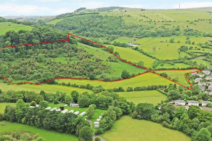
Lot B—Guide Price £175,000 - Shown shaded red on the plan, the sale of the land offers a block of grassland extending to approximately 18.54 acres (7.50 hectares), divided into multiple paddocks. Benefiting from good roadside access, the land is bound by dry stone walling, and offers a productive block of land suitable for both mowing and grazing.
The parcels of each land lend themselves to the agricultural, amenity, equestrian, and/or those with hobby farming interests.
The buyer of Lot A will have first refusal in the auction to purchase Lot B at the same price per acre as Lot A. If this is not exercised, Lot B will be auctioned in the normal way.
Directions: - From the centre of Foolow, head west through the village along then take a right just after the St, High’s Church onto Bradshaw Lane and follow the road for approximately 0.5 miles, where the land is situated on the right hand side —all indicated by our ‘For Sale’ boards.
What3words///resembles.named.increment
Services: - Both lots are not connected to mains water, however there is a natural water supply crossing both lots during part of the year.
Tenure And Possession: - The land is sold freehold, with vacant possession granted upon termination of a mowing and grazing licence the 30th October 2026.
Sporting, Timber And Mineral Rights: - The sporting, timber, and mineral rights are included in the sale as far as they exist.
Viewing: - The land may be viewed at any reasonable time when in possession of a copy of these particulars. Please park carefully and leave gates as found.
Rights Of Way, Wayleaves And Easements: - The property is sold subject to and with the benefit of all rights of way, wayleaves and easements whether or not they are described in these particulars.
Fixtures And Fittings: - Only those fixtures and fittings referred to in the sale particulars are included in the purchase price. Bagshaws have not tested any equipment, fixtures, fittings or services and no guarantee is given that they are in good working order.
Boundary Responsibility: - The internal boundary responsibility is shown by a inwards ‘T’ on the land plan.
Method Of Sale: - The property is offered by Public Auction at 3.00pm on Monday 21st September 2026 at The Agricultural Business Centre, Bakewell, Derbyshire DE45 1AH
Local Authority: - Derbyshire Dales District Council, Town Hall, Bank Rd, Matlock, Derbyshire DE4 3NN
Local Planning Authority: - Peak District National Park Authority, Aldern House, Baslow Road, Bakewell, Derbyshire DE45 1AE
Money Laundering Regulations 2017: - All bidders must provide relevant documentation in order to provide proof of their identity and place of residence before bidding. The documentation collected is for this purpose only and will not be disclosed to any other party. All bidders must register with the auctioneers prior to the auction.
Deposits & Completion: - The successful purchaser will be required to pay a deposit of 10% of the sale price upon the fall of the hammer. Please note that proof of identification must also be provided to comply with the Money Laundering Regulations 2017. The signing of the Contract of Sale and 10% deposit is legally binding on both parties and completion will occur within 42 days thereafter, unless otherwise stated at the auction. The sale of each lot is subject to a buyer’s fee of £500 plus VAT (£600 inc. of VAT) for all lots sold up to a value of £99,999. For any lots sold at or over £100,000 the buyer’s fee will be £750 plus VAT (£900 inc. of VAT), payable on the fall of the hammer. For on-line buyers only, there is an additional on-line buyer’s premium of £500 plus VAT (£600 inc. of VAT) payable on the fall of the hammer. Please contact the auctioneers for further details.
Conditions Of Sale: - The Conditions of Sale will be deposited at the office of the Auctioneers seven days prior to the sale and will not be read at the sale. The Auctioneers and Solicitors will be in the sale room fifteen minutes prior to the commencement of the auction to deal with any matter arising from either the conditions of Sale, the Sales Particulars or relating to the auction generally. At the appointed time the sale will commence and thereafter no further queries will be dealt with and the purchaser will be deemed to have full knowledge of the Conditions of Sale and to have satisfied himself fully upon all matters contained or referred to therein, whether or not the purchaser has read them. “The Guide Price is issued as an indication of the auctioneer’s opinion of the likely selling price of the property. Each property offered is subject to a Reserve Price which is agreed between the seller and the auctioneer just prior to the auction and which would ordinarily be within 10% (+/-) of the Guide Price. Both the Guide Price and the Reserve Price can be subject to change up to and including the day of the auction.
Agents Notes - Bagshaws LLP have made every reasonable effort to ensure these details offer an accurate and fair description of the property. The particulars are produced in good faith, for guidance only and do not constitute or form an offer or part of the contract for sale. Bagshaws LLP and their employees are not authorised to give any warranties or representations in relation to the sale and give notice that all plans, measurements, distances, areas and any other details referred to are approximate and based on information available at the time of printing.
Map Location
Property details
- Tenure
- Freehold
- Council Tax Band
- Ask Agent
- Date Posted
- 2026-08-19
Market Value Analysis
Compared with 123 Farmland & Pasture listings in East Midlands (10+ acres).
Utilities & Restrictions
Utilities
- Electricity
- Ask Agent
- Water
- Ask Agent
- Heating
- Ask Agent
- Broadband
- Ask Agent
- Sewerage
- Ask Agent
Rights & Restrictions
- Public Rights of Way
- Ask Agent
- Private Rights of Way
- Ask Agent
- Listed Property
- Ask Agent
- Restrictions
- Ask Agent
Listed status, conservation areas and planning constraints for this location are in the full report.
Property Features
- Accessibility
- Ask Agent
- Parking
- Off-Street Parking
- Garden
- Garden
Beyond the particulars: planning activity, flood history, heritage and ground risks, checked for this exact spot.
Connectivity
Broadband
Fastest speed available at this postcode
1.8 Gbps
Gigabit full fibre
Suitable for
- 4K streaming on every screen
- Full-time home working
- Online gaming & big downloads
Mobile signal
Predicted 4G and 5G signal; indoor signal depends on building materials.
Ofcom Connected Nations postcode-level predictions. Speeds and signal are modelled, not measured, and vary between addresses and providers.
Signal is the easy part. Planning activity, flood history and protected designations here are in the full report.
Nearest Schools
Primary
- Great Hucklow CE Primary0.9 milesOfsted: Good
- Ages
- 3 to 11
- Pupils
- 33
- Type
- Voluntary controlled school
- Faith
- Church of England
- Eyam CofE Primary School1.8 milesOfsted: Good *
- Ages
- 4 to 11
- Pupils
- 64
- Type
- Voluntary controlled school
- Faith
- Church of England
- Litton CofE Primary School2.3 milesOfsted: Good *
- Ages
- 3 to 11
- Pupils
- 42
- Type
- Voluntary aided school
- Faith
- Church of England
- Bradwell CofE (Controlled) Infant School & Nursery2.5 milesOfsted: Good
- Ages
- 2 to 7
- Pupils
- 20
- Type
- Voluntary controlled school
- Faith
- Church of England
- Stoney Middleton CofE (C) Primary School2.6 milesOfsted: Good
- Ages
- 3 to 11
- Pupils
- 20
- Type
- Voluntary controlled school
- Faith
- Church of England
Secondary
- Hope Valley College4 milesOfsted: Good
- Ages
- 11 to 18
- Pupils
- 518
- Type
- Academy sponsor led
- Lady Manners School6.2 milesOfsted: Good
- Ages
- 11 to 18
- Pupils
- 1,405
- Type
- Foundation school
- King Ecgbert School7.5 milesOfsted: Outstanding *
- Ages
- 11 to 18
- Pupils
- 1,575
- Type
- Academy converter
- Silverdale School8.5 milesOfsted: Good
- Ages
- 11 to 18
- Pupils
- 1,491
- Type
- Academy converter
- St Thomas More Catholic Voluntary Academy8.6 milesOfsted: Good *
- Ages
- 11 to 16
- Pupils
- 407
- Type
- Academy converter
- Faith
- Roman Catholic
* Latest graded judgement covers quality of education only; no overall grade was issued under the 2024-25 inspection framework.
Distances are straight-line from the advertised location. Source: the national school registers (DfE, Welsh Government, Scottish Government) and Ofsted.
Schools are just the start: sold prices nearby, planning activity and any flood history are in the full report.
Amenities
Supermarket
GP surgery
Pharmacy
Hospital
Straight-line distances from the advertised location. Sources: NHS records, Geolytix supermarket locations, OS Open Greenspace and the national trails registers.
The area stacks up? Now check the location itself: planning nearby, protected designations and past flooding.
Getting Around
Nearest station
Nearest bus stop
Typical drive times
Straight-line distances from the advertised location; drive times are typical free-flow times over OpenStreetMap road data, so allow more at peak. Public transport locations from DfT NaPTAN.
Easy to reach matters. So do planning activity, flood history and ground risks: all in the full report.
Flood Risk
Environment Agency open data, checked around the advertised map pin for the listed acreage. Long-term risk counts flood defences; the planning map's flood zones do not. Provided by LandSale, not the listing agent, and not part of the agent's particulars. Risk varies across a holding, so verify before committing.
Rivers and the sea
Planning map: Flood Zone 1.
Surface water
Not at the pin: mapped about 120 metres away.
These bandings are the summary. Where this location sits on the flood maps, plus planning activity, heritage and ground risks, is in the full report.
Important notice: Information, maps and tags on this page are drawn from the advertising agent's marketing materials or generated automatically. LandSale has not verified them. Relying on these details is at your own risk, always carry out independent checks before committing to a purchase.
LandSale full disclaimer
Marketing information only - not formal particulars. The details on this website are provided for general guidance and do not constitute an offer or contract. Neither LandSale nor the advertising estate/land agent accepts responsibility for any inaccuracy.
1. Source of information
- Listing content: Core description, asking price, tenure, measurements, photographs and planning history originate from the marketing materials of the advertising estate or land agent. LandSale does not author this content and cannot guarantee its accuracy.
- Automated tags & categorisation: Property type, land-use class, acreage bands and similar labels may be applied by machine-learning models. They are intended as a helpful guide only and may not reflect the property's legal status or permitted use.
- Third-party & enriched data layers: Maps, boundary outlines, planning designations, soil reports, broadband coverage and other environmental or location-based insights are licensed from external suppliers. Such data are supplied “as is", may be incomplete or out of date and are subject to change without notice.
2. Verification required
Prospective purchasers must verify critical matters, including but not limited to planning permission, title boundaries, public rights of way, environmental constraints, acreage, services, access and VAT status, through their own inspections, specialist surveys, legal advisers and the selling agent before relying on the information or entering into any contract.
3. No warranty or liability
LandSale gives no warranty, express or implied, as to the accuracy, completeness or fitness for any particular purpose of the information displayed. LandSale shall not be liable for any loss, damage, cost or expense arising directly or indirectly from any use of or reliance on such information, save where liability may not be excluded by law.
4. Updates & feedback
If you believe any detail on this listing is inaccurate, please let us know. We will investigate and, where appropriate, update the listing or notify the agent.
© LandSale | Version 1.3 - August 2026
Listing agent
Bagshaws, Bakewell
The Agricultural Business Centre, Agricultural Way, Bakewell, DE45 1AH
Contact Bagshaws, Bakewell
The Agricultural Business Centre, Agricultural Way, Bakewell, DE45 1AH
View agent profileSimilar properties for sale
- Price
- Offers in Region of£135,000
- Size
- 16.51 acres
Land off Brookfields, Calver, Hope Valley, Calver, Derbyshire S32 England
Added on 29/01/2026Grazing Land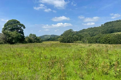
- Price
- Offers Over£200,000
- Size
- 13.34 acres
Land South of Harrop Wood, Rainow, Macclesfield, Rainow, Cheshire East SK10 England
Added on 18/06/2026Grazing Land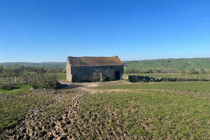
- Price
- Offers Over£140,000
- Size
- 24.21 acres
Land at Ford Wetley, Onecote, Leek, Onecote, Staffordshire ST13 England
Added on 21/05/2026Grazing Land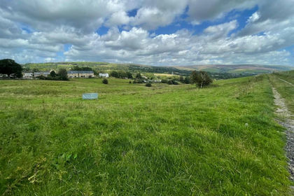
- Price
- Guide Price£170,000
- Size
- 12.72 acres
Market Street, Mottram in Longdendale, Hyde, Stalybridge and Hyde, Tameside SK14 England
Added on 13/06/2026Agricultural Land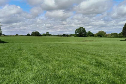
- Price
- Offers Over£190,000
- Size
- 13.08 acres
13.08 Acres Of Land Off Cookesmere Lane, Sandbach, Sandbach, Cheshire East CW11 England
Added on 10/07/2026Grazing Land
- Price
- Offers Over£175,000
- Size
- 15.83 acres
15.83 acres at Thorpe Audlin, Thorpe Audlin, Wakefield WF8 England
Added on 01/10/2026Arable Land
- Price
- Offers Over£200,000
- Size
- 9.82 acres
Land at Chase Lane, Tittensor, Swynnerton, Staffordshire ST15 England
Added on 09/06/2026Agricultural Land
- Price
- Guide Price£160,000
- Size
- 13.73 acres
Added on 08/08/2026Arable Land