Crippetts Lane, Leckhampton, Cheltenham
- Land size
- 48.22 acres
Description
48.22 Acres of pasture land.
Location - Situated less than 3 miles from Cheltenham centre, Crippetts Farm is a hidden gem nestled at the foot of Shurdinton Hill. In spite of it's extreme ease of access into Cheltenham, the land benefits from a fantastically secluded setting, accessed up an adopted road known as Crippetts Lane, which leads to Crippetts Farm and four other properties, and countryside walks and bridlepaths.
The Farmhouse and buildings (Lot 1) are set back off Crippetts Lane, with it's own private drive within the 14.82 acres encompassed in Lot 1. Lot 2 is then a ring fenced 48.22 acre parcel of pasture land which climbs up towards the top of Shurdington Hill, both lots benefiting from multiple access point up Crippetts Lane.
Description - Lot 2 extends to 48.22 acres of permanent pasture land. The land is mainly rough grazing but in good condition. Akin to a parkland layout, the land benefits from stunning ancient oak trees sparsely dotted throughout.
The land fenced with post and stock netting, which in the main is in stock proof condition, however, some stretches are dilapidated, so may require attention. There is some internal fencing for division and stock handling.
Access - The land benefits from multiple gateways along the lane and all access gates are suitable for vehicles. The main access point at the bottom of the hill is suitable for larger agricultural machinery. When accessing via the main gateway there is a stock handling area and a small area of hard standing.
Land And Soil Classification - The land is Grade 4 as stated under the MAAF Agricultural Land Classification.
Regarding the soil structure, the land is divided laterally half way up the hill, the bottom half is slowly permeable seasonally wet slightly acid but base-rich loamy and clayey soils, the top half is shallow lime-rich soils over chalk or limestone.
Altitude And Tapography - At the point of accessing the land from the main access at the bottom of the hill the land sits at an altitude of approximately 115 meters above sea level, rising to the up the hill to an altitude of approximately 225 meters above seas level at the most southern and highest point, offering an exceptional elevated position with stunning views over Cheltenham.
Previous Use - The land has in the past been used for, livestock farming, and has been grazed by sheep, cattle and horses in parts used for hay making. The land is currently being grazed with cattle.
Tenure - Freehold - Freehold with Vacant Possession upon completion.
Services - The land has a spring supply for water and is equipped with numerous water troughs.
There is no electric supply to the land. There is an electric supply to the house and buildings within lot 1.
Public Rights Of Way - There is a bridleway along the southwest corner of the Land, this is well fenced and signed preventing ingress of public onto the land. There are no other registered public rights of way over the land.
Wayleaves And Easements - The Land is sold with the benefit of all rights of way (whether public or private), light, support, drainage, water supplies, other rights and obligations, easements, quasi-easements and restrictive covenants and all wayleaves for poles, stays, cables, drains and water, gas and other pipes, whether referred to in the general Information, particulars or special conditions of the sale or otherwise and subject to all outgoings or charges connected with or chargeable whether mentioned or not.
Sporting And Mineral Rights - We understand that these are owned and included in the sale.
Viewing - Strictly by prior appointment via our Chipping Norton Office
Tel:
Email: c.
Method Of Sale - The Property is for sale as a whole by Private Treaty.
Local Authority - Tewkesbury - Tewkesbury Borough Council
Public Services Centre
Gloucester Road, Tewkesbury
Gloucestershire
GL20 5TT
Tel:
Email:
Lot 1 - Lot 1 is Crippetts Farm, including Farmhouse a range of outbuildings and 14.82 acres. The interested parties of Lot 1 shall have first refusal of Lot 2.
Agents Note - Bridlepath and footpaths as per plan
Map Location
Property details
- Tenure
- Freehold
- Council Tax Band
- Ask Agent
- Date Posted
- 2026-08-08
Market Value Analysis
Compared with 13 Bare & Undeveloped Land listings in South West England (25+ acres).
Utilities & Restrictions
Utilities
- Electricity
- Ask Agent
- Water
- Ask Agent
- Heating
- Ask Agent
- Broadband
- Ask Agent
- Sewerage
- Ask Agent
Rights & Restrictions
- Public Rights of Way
- Ask Agent
- Private Rights of Way
- Ask Agent
- Listed Property
- Ask Agent
- Restrictions
- Ask Agent
Property Features
- Accessibility
- Ask Agent
- Parking
- Parking Available
- Garden
- Ask Agent
Connectivity
Broadband
Fastest speed available at this postcode
16 Mbps
Standard (10-30 Mbps)
Suitable for
- Web & social
- Music streaming
- Standard video calls
Mobile signal
Outdoor predictions; indoor signal depends on building materials.
Ofcom Connected Nations postcode-level predictions. Speeds and signal are modelled, not measured, and vary between addresses and providers.
Nearest Schools
Primary
- Leckhampton Church of England Primary School1.1 milesOfsted: Good
- Ages
- 4 to 11
- Pupils
- 630
- Type
- Voluntary controlled school
- Faith
- Church of England
- Shurdington Church of England Primary School1.2 milesOfsted: Good *
- Ages
- 4 to 11
- Pupils
- 207
- Type
- Voluntary controlled school
- Faith
- Church of England
- Warden Hill Primary School1.3 milesOfsted: Good
- Ages
- 4 to 11
- Pupils
- 415
- Type
- Foundation school
- Greatfield Park Primary School1.4 milesOfsted: Good *
- Ages
- 4 to 11
- Pupils
- 183
- Type
- Community school
- St James' Church of England Primary School1.6 milesOfsted: Good
- Ages
- 4 to 11
- Pupils
- 408
- Type
- Academy converter
- Faith
- Church of England
Secondary
- The High School Leckhampton1 mileOfsted: Outstanding
- Ages
- 11 to 16
- Pupils
- 759
- Type
- Free schools
- Cheltenham Bournside School and Sixth Form Centre1.6 milesOfsted: Good
- Ages
- 11 to 18
- Pupils
- 1,846
- Type
- Academy converter
- Balcarras School2.5 milesOfsted: Outstanding *
- Ages
- 11 to 18
- Pupils
- 1,427
- Type
- Academy converter
- Henley Bank High School2.5 milesOfsted: Good
- Ages
- 11 to 18
- Pupils
- 916
- Type
- Academy sponsor led
- Chosen Hill School3 milesOfsted: Good *
- Ages
- 11 to 18
- Pupils
- 1,295
- Type
- Academy converter
* Latest graded judgement covers quality of education only; no overall grade was issued under the 2024-25 inspection framework.
Distances are straight-line from the advertised location. Source: the national school registers (DfE, Welsh Government, Scottish Government) and Ofsted.
Amenities
Supermarket
GP surgery
Pharmacy
Hospital
Green space
Walking trail
Straight-line distances from the advertised location. Sources: NHS records, Geolytix supermarket locations, OS Open Greenspace and the national trails registers.
Getting Around
Nearest station
Nearest bus stop
Typical drive times
Straight-line distances from the advertised location; drive times are typical free-flow times over OpenStreetMap road data, so allow more at peak. Public transport locations from DfT NaPTAN.
Flood Risk
From Environment Agency flood map open data, checked around the advertised map pin and allowing for the listed acreage where known. This summary comes from LandSale, the advertising platform, not from the listing agent, and is not part of the agent's particulars. Risk can vary across a single holding, so verify anything critical through your own searches before committing.
Rivers and the sea
Surface water
Mapped within the area searched, not at the advertised map pin itself.
The detail behind these bandings, including exact zones and annual chances, any recorded past flooding, plus planning, heritage, nature and ground checks, is in the .
Important notice: Information, maps and tags on this page are supplied by the advertising agent or generated automatically. LandSale has not verified them. Relying on these details is at your own risk, always carry out independent checks before committing to a purchase.
LandSale full disclaimer
Marketing information only - not formal particulars. The details on this website are provided for general guidance and do not constitute an offer or contract. Neither LandSale nor the advertising estate/land agent accepts responsibility for any inaccuracy.
1. Source of information
- Agent-supplied content: Core description, asking price, tenure, measurements, photographs and planning history are uploaded by the appointed agent, who remains solely responsible for their accuracy.
- Automated tags & categorisation: Property type, land-use class, acreage bands and similar labels may be applied by machine-learning models. They are intended as a helpful guide only and may not reflect the property's legal status or permitted use.
- Third-party & enriched data layers: Maps, boundary outlines, planning designations, soil reports, broadband coverage and other environmental or location-based insights are licensed from external suppliers. Such data are supplied “as is", may be incomplete or out of date and are subject to change without notice.
2. Verification required
Prospective purchasers must verify critical matters, including but not limited to planning permission, title boundaries, public rights of way, environmental constraints, acreage, services, access and VAT status, through their own inspections, specialist surveys, legal advisers and the selling agent before relying on the information or entering into any contract.
3. No warranty or liability
LandSale gives no warranty, express or implied, as to the accuracy, completeness or fitness for any particular purpose of the information displayed. LandSale shall not be liable for any loss, damage, cost or expense arising directly or indirectly from any use of or reliance on such information, save where liability may not be excluded by law.
4. Updates & feedback
If you believe any detail on this listing is inaccurate, please let us know. We will investigate and, where appropriate, update the listing or notify the agent.
© LandSale | Version 1.2 - January 2026
Listing agent
Tayler & Fletcher, Chipping Norton
Finsbury House, New Street, Chipping Norton, OX7 5LS
Contact Tayler & Fletcher, Chipping Norton
Finsbury House, New Street, Chipping Norton, OX7 5LS
View agent profileSimilar properties for sale
- Price
- Offers in Excess of£480,000
- Size
- 48.77 acres
Added on 10/08/2026Agricultural Land
- Price
- Guide Price£395,000
- Size
- 33.03 acres
33.03 Acres Arable Land, Hatfield, Worcester, Norton Juxta Kempsey, Worcestershire WR5 England
Added on 17/08/2026Arable Land
- Price
- Guide Price£475,000
- Size
- 48.54 acres
Added on 29/01/2026Arable Land
- Price
- £500,000
- Size
- 44.06 acres
Tedstone Wafre, Bromyard, Edvin Loach and Saltmarshe, Herefordshire, County of HR7 England
Added on 29/01/2026Farmland
- Price
- Offers in Excess of£400,000
- Size
- 40.68 acres
Tregare, Monmouth, NP25, Mitchel Troy, Monmouthshire NP25 Wales
Added on 16/07/2026Vacant Land
- Price
- Offers in Excess of£390,000
- Size
- 30.2 acres
Keynsham, Bristol, BS30, Hanham Abbots, South Gloucestershire BS30 England
Added on 10/03/2026Pasture
- Price
- Guide Price£460,000
- Size
- 51.33 acres
Added on 08/08/2026Agricultural Land
- Price
- £500,000
- Size
- 52.02 acres
Pant Y Colyn Farm, Llanvetherine NP7, Whitecastle, Monmouthshire NP7 Wales
Added on 29/01/2026Pasture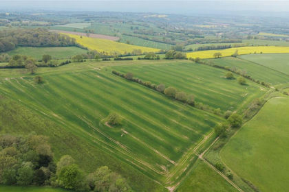
- Price
- £560,000
- Size
- 56.44 acres
Lot 5, Parsonage Farm, Kyre, Tenbury Wells, Worcestershire, Kyre, Worcestershire WR15 England
Added on 16/05/2026Farm
- Price
- Offers in Excess of£400,000
- Size
- 39.7 acres
Added on 26/06/2026Pasture