
School Lane, Rothwell
Key Features
- Building Plot with full planning permission
- Wolds village location
- Quiet no through road
- Plans for a detached house and garage
- Gardens
- Attractive design
- Popular village
- VAT payable in addition to sale price
Description
An excellent opportunity to acquire a generous building plot in a popular Lincolnshire Wolds village benefitting from full planning permission for the erection of a three/four bedroom home with detached garage. The well planned accommodation offers versatile family living space extending to around 1,375 square feet. Adjacent the house will be a garage and driveway with gardens to front, side and rear. Well positioned in an elevated spot a short walk to the popular village pub and just a few minutes' drive to amenities in Caistor.
Location Rothwell is a pretty rural village set in the heart of the Lincolnshire Wolds an Area of Outstanding Natural Beauty and enjoys a good local pub called The Blacksmith's Arms. Neighbouring Caistor offers local amenities including the well respected Caistor Grammar School and Grimsby is approximately 14 miles away with the full range of shopping facilities, leisure amenities and a further choice of schools. Humberside Airport is also very accessible at approximately 9 miles away. Louth and Cadwell Park are also within easy reach. The vibrant market town of Market Rasen is approximately 10 miles away with its race course and extensive rail links to Lincoln, Newark, London and beyond.
Directions From the centre of Rothwell village on Caistor road, take the turning up School Lane opposite The Blacksmith's Arms public house. Travel a short way up the lane and the plot will be found on the left.
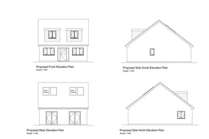
The Proposed Dwelling and Plot The plot enjoys a very quiet position along a no through road that leads to the village Church, in an elevated setting offering some superb views of the surrounding countryside. The plot has a gentle gradient and sits slightly above the road level. The plot has a mature setting with hedging and trees to boundaries and is set between existing residential dwellings. The proposed dwelling is of a traditional design with brick facing walls under pitched and tiled roofs, with an adjacent garage in a complementary design. It is anticipated that the dwelling will use an air source heat pump heating system supplemented by solar panels fitted to the rear roof aspect.
There will be ample amenity space around the new dwelling comprising a generous parking area along with front, side and rear gardens. The plans respond sympathetically to the character of the village setting and neighbouring properties.
Accommodation The dwelling has been designed with contemporary and versatile living in mind and the layout can be viewed on the enclosed plans. It comprises; A front porch giving access to the entrance hall. To the left is the snug and study/fourth bedroom, beyond which is the WC and utility room. A door to the right gives access to a large open plan family space comprising dining and sitting area adjacent a fireplace leading into the spacious kitchen with central island, having vaulted ceiling with sky lights and windows to both aspects and patio doors to rear garden.
On the first floor there is a spacious gallery landing with large master bedroom suite to the left comprising a double bedroom with en suite shower room. On the opposite side are 2 further bedrooms and a family bathroom. Adjacent to the house will be a single detached garage.
Planning Full planning permission was granted (application number 146713) by the West Lindsey District Council Planning Department on 20th September 2024. Details can be emailed by the selling agent on request. We recommend that the planning decision notice be considered in full, together with all the associated conditions and documentation before submitting an offer. The archaeological investigation dig and report mentioned in the decision notice has been completed by the vendor and can be made available to prospective purchasers.
Method of Sale The land is for sale by Private Treaty.
Council Tax and Business Rates The property is not recorded on the West Lindsey District Council website for council tax purposes but any residential occupation such as that for which permission has been granted would alter this position.
Sporting and Mineral Rights These are included in the sale where they are owned.
Wayleaves, Easements, Covenants and Rights of Way
The land is sold subject to and with the benefit of all existing wayleaves, easements and quasi-easements and rights of way, whether mentioned in these particulars or not. The land can be accessed directly from the public highway via an existing pedestrian gate.
Tenure The land is offered for sale freehold with vacant possession on completion.
VAT
VAT will be chargeable in addition the agreed sale price. Such tax will be payable by the buyer(s) in addition to the contract price. A business purchaser may be able to recover this VAT and should seek guidance from their conveyancer.
Viewing You may enter the site on foot only during daylight hours and by prior appointment. Please contact the selling agent for further information on viewing and to register your interest.
General Information The particulars of this property are intended to give a fair and substantially correct overall description for the guidance of intending purchasers. Plans/Maps are not to specific scale, are based on information supplied and subject to verification by a solicitor at sale stage. It is anticipated that the new dwelling will be connected to mains drainage, electricity and water available in the village– applicants should satisfy themselves as to the precise position and accessibility of these services. BDLD
Map Location
Property details
- Tenure
- Ask Agent
- Council Tax Band
- Ask Agent
- Date Posted
- 2026-08-05
Property Brochure
Seen the details? The full report adds the independent checks: planning activity, flood history, heritage and ground.
Utilities & Restrictions
Utilities
- Electricity
- Ask Agent
- Water
- Ask Agent
- Heating
- Ask Agent
- Broadband
- Ask Agent
- Sewerage
- Ask Agent
Rights & Restrictions
- Public Rights of Way
- Ask Agent
- Private Rights of Way
- Ask Agent
- Listed Property
- Ask Agent
- Restrictions
- Ask Agent
Listed status, conservation areas and planning constraints for this location are in the full report.
Property Features
- Accessibility
- Ask Agent
- Parking
- Ask Agent
- Garden
- Ask Agent
Beyond the particulars: planning activity, flood history, heritage and ground risks, checked for this exact spot.
Connectivity
Broadband
Fastest speed available at this postcode
72 Mbps
Superfast
Suitable for
- HD streaming
- Video calls
- Web & social
Mobile signal
Predicted 4G and 5G signal; indoor signal depends on building materials.
Ofcom Connected Nations postcode-level predictions. Speeds and signal are modelled, not measured, and vary between addresses and providers.
Signal is the easy part. Planning activity, flood history and protected designations here are in the full report.
Nearest Schools
Primary
- Caistor CofE and Methodist Primary School2.2 milesNo Ofsted rating
- Ages
- 3 to 11
- Pupils
- 189
- Type
- Voluntary controlled school
- Faith
- Church of England/Methodist
- Nettleton Community Primary School2.7 milesNo Ofsted rating
- Ages
- 4 to 11
- Pupils
- 65
- Type
- Community school
- Binbrook CofE Primary School4.9 milesOfsted: Good
- Ages
- 4 to 11
- Pupils
- 73
- Type
- Voluntary controlled school
- Faith
- Church of England
- Grasby All Saints Church of England Primary School5.2 milesNo Ofsted rating
- Ages
- 3 to 11
- Pupils
- 89
- Type
- Voluntary controlled school
- Faith
- Church of England
- Tealby School5.4 milesOfsted: Good
- Ages
- 4 to 11
- Pupils
- 83
- Type
- Community school
Secondary
- Caistor Yarborough Academy2.1 milesOfsted report card · Dec 2025
- Ages
- 11 to 16
- Pupils
- 680
- Type
- Academy converter
- Caistor Grammar School2.5 milesOfsted: Good
- Ages
- 11 to 18
- Pupils
- 690
- Type
- Academy converter
- De Aston School7 milesNo Ofsted rating
- Ages
- 11 to 18
- Pupils
- 939
- Type
- Academy converter
- Faith
- Christian
- Healing Academy7.9 milesOfsted: Good
- Ages
- 11 to 16
- Pupils
- 751
- Type
- Academy converter
- Waltham Toll Bar Academy8.3 milesOfsted: Good
- Ages
- 11 to 18
- Pupils
- 1,611
- Type
- Academy converter
Distances are straight-line from the advertised location. Source: the national school registers (DfE, Welsh Government, Scottish Government) and Ofsted.
Schools are just the start: sold prices nearby, planning activity and any flood history are in the full report.
Amenities
Supermarket
GP surgery
Pharmacy
Hospital
Green space
Straight-line distances from the advertised location. Sources: NHS records, Geolytix supermarket locations, OS Open Greenspace and the national trails registers.
The area stacks up? Now check the location itself: planning nearby, protected designations and past flooding.
Getting Around
Nearest station
Nearest bus stop
Typical drive times
Straight-line distances from the advertised location; drive times are typical free-flow times over OpenStreetMap road data, so allow more at peak. Public transport locations from DfT NaPTAN.
Easy to reach matters. So do planning activity, flood history and ground risks: all in the full report.
Flood Risk
Environment Agency open data, checked around the advertised map pin for the listed acreage. Long-term risk counts flood defences; the planning map's flood zones do not. The map pin for this listing marks the postcode area rather than the exact location, so these readings describe the surrounding area. Provided by LandSale, not the listing agent, and not part of the agent's particulars. Risk varies across a holding, so verify before committing.
Rivers and the sea
Planning map: Flood Zone 1.
Surface water
These bandings are the summary. Where this location sits on the flood maps, plus planning activity, heritage and ground risks, is in the full report.
Important notice: Information, maps and tags on this page are drawn from the advertising agent's marketing materials or generated automatically. LandSale has not verified them. Relying on these details is at your own risk, always carry out independent checks before committing to a purchase.
LandSale full disclaimer
Marketing information only - not formal particulars. The details on this website are provided for general guidance and do not constitute an offer or contract. Neither LandSale nor the advertising estate/land agent accepts responsibility for any inaccuracy.
1. Source of information
- Listing content: Core description, asking price, tenure, measurements, photographs and planning history originate from the marketing materials of the advertising estate or land agent. LandSale does not author this content and cannot guarantee its accuracy.
- Automated tags & categorisation: Property type, land-use class, acreage bands and similar labels may be applied by machine-learning models. They are intended as a helpful guide only and may not reflect the property's legal status or permitted use.
- Third-party & enriched data layers: Maps, boundary outlines, planning designations, soil reports, broadband coverage and other environmental or location-based insights are licensed from external suppliers. Such data are supplied “as is", may be incomplete or out of date and are subject to change without notice.
2. Verification required
Prospective purchasers must verify critical matters, including but not limited to planning permission, title boundaries, public rights of way, environmental constraints, acreage, services, access and VAT status, through their own inspections, specialist surveys, legal advisers and the selling agent before relying on the information or entering into any contract.
3. No warranty or liability
LandSale gives no warranty, express or implied, as to the accuracy, completeness or fitness for any particular purpose of the information displayed. LandSale shall not be liable for any loss, damage, cost or expense arising directly or indirectly from any use of or reliance on such information, save where liability may not be excluded by law.
4. Updates & feedback
If you believe any detail on this listing is inaccurate, please let us know. We will investigate and, where appropriate, update the listing or notify the agent.
© LandSale | Version 1.3 - August 2026
Similar properties for sale
 Added on 24/02/2026Building Plot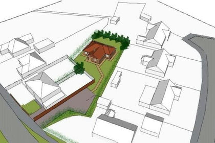
- Price
- Guide Price£74,000
- Size
- 0.17 acres
Added on 29/01/2026Self Build Plot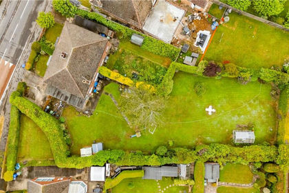
- Price
- Guide Price£74,000
- Size
- 0.17 acres
Station Road, Stallingborough, DN41, Stallingborough, North East Lincolnshire DN41 England
Added on 19/09/2026Self Build Plot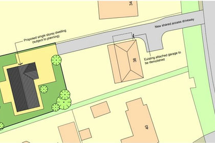
- Price
- £95,000
- Size
- 0.18 acres
Stallingborough Road, Immingham, DN40, Immingham, North East Lincolnshire DN40 England
Added on 21/05/2026Self Build Plot
- Price
- Guide Price£80,000
Brigg Road, Wrawby, DN20, Wrawby, North Lincolnshire DN20 England
Added on 27/03/2026Building Plot Added on 29/05/2026Building Plot
- Price
- Offers Over£110,000
Segmere Street, Cleethorpes, Great Grimsby and Cleethorpes, North East Lincolnshire DN35 England
Added on 10/04/2026Building Plot
- Price
- Offers in Region of£75,000
Jericho Lane, East Halton, East Halton, North Lincolnshire DN40 England
Added on 28/02/2026Self Build Plot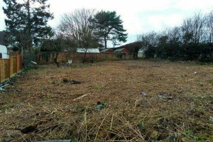
- Price
- Guide Price£50,000
- Size
- 0.13 acres
Land at the rear of, 21 Grimsby Road, Louth, Lincolnshire, LN11, Louth, Lincolnshire LN11 England
Added on 02/10/2026Building Plot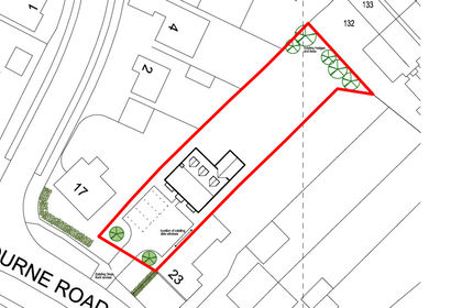
- Price
- £100,000
- Size
- 0.23 acres
Legbourne Road, Louth LN11, Louth, Lincolnshire LN11 England
Added on 03/06/2026Building Plot