Hayscastle, SA62
- Bedrooms
- 3
- Bathrooms
- 3
Key Features
- Exciting Development Opportunity: Two characterful stone barns with full planning permission to create a stunning, linked 3-bedroom rural home.
- Breathtaking Uninterrupted Views: Perfectly positioned to take full advantage of spectacular, panoramic views over the eastern fields and down the valley.
- Idyllic & Private Setting: Nestled in rolling Pembrokeshire countryside with a long private driveway, gardens, and the option to purchase additional land.
- Prime Coastal Location: A peaceful rural haven just 3 miles from Newgale Beach and within easy reach of both St Davids and Haverfordwest.
Description
The Old Mill comprises two stone barns with is full planning permission in place for their conversion into one three-bedroom home. The two stone structures would be linked by a central extension which would take full advantage of the uninterrupted views out over the fields to the east. This superb outlook is a major selling point to the project, with an uninterrupted view out over the fields behind the property and down the valley. The Old Mill benefits from a long driveway leading around to the front of the buildings. There is space to the front and rear of the structures with the promise of lovely gardens to create both sheltered seating areas and lawns to enjoy.
The Old Mill has electricity and mains water on hand to be connected with the option of additional land to the north if required by separate negotiation.
Set within the rolling countryside of western Pembrokeshire, Old Mill enjoys an exceptional rural setting that offers both peace and privacy. The property is conveniently located just a short three mile drive from the award-winning beach at Newgale, renowned for its expansive golden sands and spectacular coastline. The historic city of St Davids, the UK's smallest city, is approximately twenty minutes away and offers a wealth of independent shops, galleries, cafés and restaurants. The county town of Haverfordwest is also within easy reach, providing a comprehensive range of shopping, educational, healthcare and transport facilities. Perfectly positioned to enjoy the best of Pembrokeshire, Old Mill combines the charm of country living with excellent access to the county's celebrated coastline, beaches and everyday amenities.
External
The barn enjoys its own access from the public lane along with parking and space around it. The Old Mill has a long driveway leading around to the barns which runs along the neighbouring field edge. There has been groundwork undertaken to create gardens for each building which have been laid to lawn. The barns enjoy an uninterrupted view out over the countryside to the east, a superb outlook which the current plans take full advantage of.
There is the option of additional land to the north if required by separate negotiation.
Directions
From the county town of Haverfordwest proceed north on the B4330 passing Camrose and Hayscastle Cross. At Hayscastle Cross take the left hand turn by the pub and follow this road out of the village. At the crossroads turn right and continue on this road passing through a farmyard and past St Mary’s Church. Passing Castle Hil Farm head into some woodland then take the left-hand fork and follow the road around and you will come to Lower Tancredston on your left-hand side.
The entrances to the Old Dairy and Old Mill are first on your left-hand side.
What3Words location for entrance to Old Mill: ///tragedy.forgotten.beaks
Disclaimer
Disclaimer
1.Money laundering regulations: Intending purchasers will be asked to produce identification documentation at a later stage, and we would ask for your co-operation in order that there will be no delay in agreeing the sale.
2. General: While we endeavour to make our sales particulars fair, accurate and reliable, they are only a general guide to the property and, accordingly, if there is any point which is of particular importance to you, please contact the office and we will be pleased to check the position for you, especially if you are contemplating travelling some distance to view the property.
3. Any measurements and distances indicated are supplied for guidance only and as such must be considered incorrect.
4. Services: Please note we have not tested the services or any of the equipment or appliances in this property, accordingly we strongly advise prospective buyers to commission their own survey or service reports before f...
Map Location
Property details
- Tenure
- Freehold
- Council Tax Band
- E
- Date Posted
- 2026-07-21
Utilities & Restrictions
Utilities
- Electricity
- Mains
- Water
- Mains
- Heating
- Oil Heating
- Broadband
- Ask Agent
- Sewerage
- Mains
Rights & Restrictions
- Public Rights of Way
- Ask Agent
- Private Rights of Way
- Ask Agent
- Listed Property
- Ask Agent
- Restrictions
- Ask Agent
Listed status, conservation areas and planning constraints for this location are in the full report.
Property Features
- Accessibility
- Ask Agent
- Parking
- Parking Available
- Garden
- Garden
Beyond the particulars: planning activity, flood history, heritage and ground risks, checked for this exact spot.
Connectivity
Broadband
Fastest speed available at this postcode
1.8 Gbps
Gigabit full fibre
Suitable for
- 4K streaming on every screen
- Full-time home working
- Online gaming & big downloads
Mobile signal
Predicted 4G and 5G signal; indoor signal depends on building materials.
Ofcom Connected Nations postcode-level predictions. Speeds and signal are modelled, not measured, and vary between addresses and providers.
Signal is the easy part. Planning activity, flood history and protected designations here are in the full report.
Nearest Schools
Primary
- Roch Community School3 miles
- Pupils
- 126
- Type
- Nursery, Infants & Juniors
- Language
- English medium school / provision
- Ysgol Ger y Llan4 miles
- Pupils
- 101
- Type
- Nursery, Infants & Juniors
- Language
- Welsh medium school / provision (including transitional)
- Ysgol Gymunedol Croesgoch4.3 miles
- Pupils
- 108
- Type
- Nursery, Infants & Juniors
- Language
- Welsh medium school / provision (including transitional)
- Wolfscastle Communty Primary School4.6 miles
- Pupils
- 50
- Type
- Nursery, Infants & Juniors
- Language
- Welsh medium school / provision (including transitional)
- Ysgol Penrhyn Dewi5.3 miles
- Pupils
- 606
- Type
- Middle (ages 3-16)
- Language
- English medium school / provision
Secondary
- Ysgol Penrhyn Dewi5.3 miles
- Pupils
- 606
- Type
- Middle (ages 3-16)
- Language
- English medium school / provision
- Ysgol Caer Elen7.3 miles
- Pupils
- 907
- Type
- Middle (ages 3-16)
- Language
- Welsh medium school / provision (including transitional)
- Haverfordwest High VC School7.9 miles
- Pupils
- 1,699
- Type
- Secondary (ages 11-19)
- Language
- English medium school / provision
- Ysgol Bro Gwaun8 miles
- Pupils
- 574
- Type
- Secondary (ages 11-16)
- Language
- Dual language school / provision (Welsh and English) (including transitional)
- Milford Haven School12 miles
- Pupils
- 1,045
- Type
- Secondary (ages 11-16)
- Language
- English medium school / provision
Distances are straight-line from the advertised location. Source: the national school registers (DfE, Welsh Government, Scottish Government) and Ofsted.
Schools are just the start: sold prices nearby, planning activity and any flood history are in the full report.
Amenities
Supermarket
GP surgery
Pharmacy
Straight-line distances from the advertised location. Sources: NHS records, Geolytix supermarket locations, OS Open Greenspace and the national trails registers.
The area stacks up? Now check the location itself: planning nearby, protected designations and past flooding.
Getting Around
Nearest station
Nearest bus stop
Typical drive times
Straight-line distances from the advertised location; drive times are typical free-flow times over OpenStreetMap road data, so allow more at peak. Public transport locations from DfT NaPTAN.
Easy to reach matters. So do planning activity, flood history and ground risks: all in the full report.
Flood Risk
Natural Resources Wales open data, checked around the advertised map pin for the listed acreage. Long-term risk counts flood defences; the planning map's flood zones do not. Provided by LandSale, not the listing agent, and not part of the agent's particulars. Risk varies across a holding, so verify before committing.
Rivers and the sea
Planning map: Flood Zone 1.
Surface water
These bandings are the summary. Where this location sits on the flood maps, plus planning activity, heritage and ground risks, is in the full report.
Important notice: Information, maps and tags on this page are drawn from the advertising agent's marketing materials or generated automatically. LandSale has not verified them. Relying on these details is at your own risk, always carry out independent checks before committing to a purchase.
LandSale full disclaimer
Marketing information only - not formal particulars. The details on this website are provided for general guidance and do not constitute an offer or contract. Neither LandSale nor the advertising estate/land agent accepts responsibility for any inaccuracy.
1. Source of information
- Listing content: Core description, asking price, tenure, measurements, photographs and planning history originate from the marketing materials of the advertising estate or land agent. LandSale does not author this content and cannot guarantee its accuracy.
- Automated tags & categorisation: Property type, land-use class, acreage bands and similar labels may be applied by machine-learning models. They are intended as a helpful guide only and may not reflect the property's legal status or permitted use.
- Third-party & enriched data layers: Maps, boundary outlines, planning designations, soil reports, broadband coverage and other environmental or location-based insights are licensed from external suppliers. Such data are supplied “as is", may be incomplete or out of date and are subject to change without notice.
2. Verification required
Prospective purchasers must verify critical matters, including but not limited to planning permission, title boundaries, public rights of way, environmental constraints, acreage, services, access and VAT status, through their own inspections, specialist surveys, legal advisers and the selling agent before relying on the information or entering into any contract.
3. No warranty or liability
LandSale gives no warranty, express or implied, as to the accuracy, completeness or fitness for any particular purpose of the information displayed. LandSale shall not be liable for any loss, damage, cost or expense arising directly or indirectly from any use of or reliance on such information, save where liability may not be excluded by law.
4. Updates & feedback
If you believe any detail on this listing is inaccurate, please let us know. We will investigate and, where appropriate, update the listing or notify the agent.
© LandSale | Version 1.3 - August 2026
Listing agent
Pembrokeshire Properties, HaverfordwestUnit 29 Withybush Road, SA62 4BS
View agent profileSimilar properties for sale
- Price
- Guide Price£225,000
- Size
- 0.5 acres
Cuffern, Roch, SA62, Nolton and Roch, Pembrokeshire SA62 Wales
Added on 24/03/2026Conversion Land Added on 18/06/2026Development Land
- Price
- £250,000
- Size
- 18 acres
Sardis, Pembrokeshire, SA62, Burton, Pembrokeshire SA62 Wales
Added on 28/08/2026Development Land Added on 29/01/2026Building Plot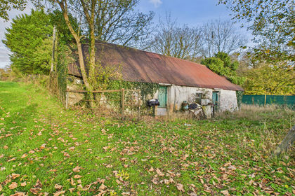
- Price
- Offers in the Region Of£195,000
- Size
- 0.33 acres
Added on 29/07/2026Building Plot