The Talbot, The Talbot Hotel, Bromyard Road, Knightwick, Worcestershire
Key Features
- 11 en suite letting bedrooms
- Bar, restaurant & function areas
- 3 bedroom cottage
- Fully equipped micro-brewery & separate bakery
- Turnover £862,792 net of VAT
- For sale after 40 years in the same family's hands
- SELLER REF 91191
Description
The hamlet of Knightwick stands on the Herefordshire/Worcestershire border alongside the River Teme in the lea of the Bromyard Downs.
It is located on the A44 trunk route linking the city of Worcester (nine miles) with the Herefordshire market town of Bromyard (six miles), in a very desirable and attractive residential location
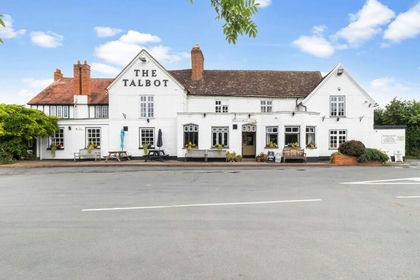
The subject property, The Talbot, dates back to the 17th century and is Grade II Listed. It is a traditional country inn with extensive restaurant, bar and function facilities as well as 11 en suite bedrooms, owners/staff cottage and sizeable gardens which overlook the beautiful River Teme.
There is also a separate well known micro-brewery which is located in a commercial unit to the rear, as well as a former (but still fully equipped) commercial bakery.
The property is briefly described as follows:-
GROUND FLOOR
There are six separate trading rooms at ground floor, mostly with an immense amount of period charm and character. Firstly is the PUBLIC BAR/SNUG which is independent of the dining areas. It has beamed walls and ceilings, flagged floor throughout, counter from CENTRAL BAR SERVERY which has a panelled front, and assorted traditional seating for 20 or so customers.
Two-section LOUNGE/DINING ROOM located to either side of an inglenook fireplace which has a cast iron log burner. The room has a quarry tiled floor and, in the main lounge area adjacent to the bar servery, there is seating for about 20. Dining area beyond, similarly appointed, with further seating for 40.
Adjacent GAMES ROOM hosted in one of the inn’s most charming rooms. It has in the past, before the trading areas were extended, been utilised as an additional dining area. There are beamed walls and ceiling, part panelled walls and the room has a feature part vaulted ceiling. Stunning fireplace with stone mullion mantelpiece, cast iron solid fuel boiler and quarry tiled hearth. There is seating for approximately 20.
To the rear if the main dining room and accessed via double doors is a conservatory style RESTAURANT which has sliding doors opening onto the front patio and the side lawned garden. This room has seating for 60 diners and is often utilised for functions.
Two further charming rooms titled ‘The Library’ and the ‘Garden Room’ which are utilised for private dining areas/small meeting rooms, as well as overflow restaurant areas. Both rooms seat 16 customers each.
Extensive and comprehensively equipped CATERING KITCHEN having a full selection of stainless steel work surfaces and catering effects. Two sets of LADIES’ & GENTLEMEN’S TOILETS and basement BEER CELLAR.
MICRO-BREWERY
The owners of The Talbot founded and run a well-known local brewery known as the ‘Teme Valley Brewery’. It is located in a commercial building located to the rear of the public house and has a capacity of 30 weekly barrels totalling 1080 gallons. They currently average 360 gallons per week.
In a Nissan hut and also located it the rear is a former BAKERY which is fully equipped. It is no longer operating commercially, but is utilised to provide bread for the public house. Large Dry Store and two walk-in Cold Rooms again utilised by the public house, and these areas are conveniently located adjacent to the rear access to the trade kitchen.
Owners’ Accommodation
COTTAGE
Attached to the main public house and with a separate external entrance is the OWNER’S/STAFF COTTAGE comprising:- GROUND FLOOR : KITCHEN with conservatory area (utilised as a lounge/dining room). LOUNGE (or bedroom) with en suite SHOWER ROOM. FIRST FLOOR : 3 BEDROOMS (1 double, 2 singles) sharing a family SHOWER ROOM.
Letting Accommodation
FIRST FLOOR
11 well appointed en suite LETTING BEDROOMS (9 double/twins, 2 singles). One bedroom is currently utilised as an OFFICE.
EXTERNAL
To the front of the property is a seating area with direct access from the trading areas, part covered by the canopy adjacent to the conservatory area. The seating areas wrap around the public house and also have access from the conservatory and appropriately named ‘Garden Room’. There is an extensive lawned garden area. OUTBUILDING/STABLES with five loose boxes.
On the opposite side of the lane to the front of the property, as well as a CAR PARK for 20, is an extensive lawned section which has timber framed bench seating etc, and overlooks the river.
To the rear is hard-standing and grassed area part utilised for OVERSPILL CAR PARKING for about 60, and part home to the locality’s Sunday markets. There are four hook-ups for caravans and camper vans etc and also, on the grassed area, is a camping area for tents.
NB : As defined on the attached plan, that this area is not owned by the public house but for a generation or more has been rented from a local farmer.
The Talbot has been in the same family hands for over 40 years. Whilst it sounds cliched, the business has been established as one of the most renowned properties in the whole of the west of England, being a focal point for much of the rural community and the various country pursuits.
Accounts for the year ended 31st March 2025 show takings net of VAT of £862,792 although it should be noted that 14% (£125,000) is derived from the Teme Valley Brewery).
The public house shows a gross profit of 72%, the brewery 56%. Whilst we do not have a direct split on trade for the inn, our client feels the bedrooms are under-utilised and should, with greater promotion, prove to be a more prominent sector of this business’s income.
This is an outstanding public house available for purchase for the first time in almost two generations.
FREEHOLD £850,000 to include goodwill, fixtures and fittings. Stock at valuation in addition.
No direct approach to be made to the business; please direct all communications through Sidney Phillips.
Viewing strictly by appointment only.
A Premises Licence is held.
All mains services are connected.
Rateable Value: £72,500 as from 1st April 2026
Local Authority: Worcestershire County Council –
Map Location
Property details
- Tenure
- Freehold
- Council Tax Band
- Ask Agent
- Date Posted
- 2026-07-17
Utilities & Restrictions
Utilities
- Electricity
- Ask Agent
- Water
- Ask Agent
- Heating
- Ask Agent
- Broadband
- Ask Agent
- Sewerage
- Ask Agent
Rights & Restrictions
- Public Rights of Way
- Ask Agent
- Private Rights of Way
- Ask Agent
- Listed Property
- Ask Agent
- Restrictions
- Ask Agent
Listed status, conservation areas and planning constraints for this location are in the full report.
Property Features
- Accessibility
- Ask Agent
- Parking
- Ask Agent
- Garden
- Ask Agent
Beyond the particulars: planning activity, flood history, heritage and ground risks, checked for this exact spot.
Connectivity
Broadband
Fastest speed available at this postcode
80 Mbps
Superfast
Suitable for
- HD streaming
- Video calls
- Web & social
Mobile signal
Outdoor predictions; indoor signal depends on building materials.
Ofcom Connected Nations postcode-level predictions. Speeds and signal are modelled, not measured, and vary between addresses and providers.
Signal is the easy part. Planning activity, flood history and protected designations here are in the full report.
Nearest Schools
Primary
- Broadwas CofE Aided Primary School1.7 milesOfsted report card · Feb 2026
- Ages
- 4 to 11
- Pupils
- 79
- Type
- Voluntary aided school
- Faith
- Church of England
- Martley CofE Primary School2.9 milesNo Ofsted rating
- Ages
- 2 to 11
- Pupils
- 160
- Type
- Academy converter
- Faith
- Church of England
- Suckley Primary School2.9 milesOfsted: Outstanding *
- Ages
- 4 to 11
- Pupils
- 95
- Type
- Academy converter
- Clifton upon Teme Primary School3.6 milesNo Ofsted rating
- Ages
- 4 to 11
- Pupils
- 72
- Type
- Community school
- Brockhampton Primary School3.6 milesNo Ofsted rating
- Ages
- 2 to 11
- Pupils
- 191
- Type
- Academy converter
Secondary
- The Chantry School2.9 milesOfsted: Good
- Ages
- 11 to 16
- Pupils
- 881
- Type
- Academy converter
- Dyson Perrins CofE Academy5.5 milesOfsted: Good
- Ages
- 11 to 16
- Pupils
- 592
- Type
- Academy converter
- Faith
- Church of England
- Queen Elizabeth High School5.5 milesNo Ofsted rating
- Ages
- 11 to 16
- Pupils
- 421
- Type
- Academy converter
- Christopher Whitehead Language College6.8 milesNo Ofsted rating
- Ages
- 11 to 18
- Pupils
- 1,580
- Type
- Academy converter
- Bishop Perowne CofE College7.4 milesOfsted: Good
- Ages
- 11 to 16
- Pupils
- 1,155
- Type
- Academy converter
- Faith
- Church of England
* Latest graded judgement covers quality of education only; no overall grade was issued under the 2024-25 inspection framework.
Distances are straight-line from the advertised location. Source: the national school registers (DfE, Welsh Government, Scottish Government) and Ofsted.
Schools are just the start: sold prices nearby, planning activity and any flood history are in the full report.
Amenities
Supermarket
GP surgery
Pharmacy
Hospital
Green space
Straight-line distances from the advertised location. Sources: NHS records, Geolytix supermarket locations, OS Open Greenspace and the national trails registers.
The area stacks up? Now check the location itself: planning nearby, protected designations and past flooding.
Getting Around
Nearest station
Nearest bus stop
Typical drive times
Straight-line distances from the advertised location; drive times are typical free-flow times over OpenStreetMap road data, so allow more at peak. Public transport locations from DfT NaPTAN.
Easy to reach matters. So do planning activity, flood history and ground risks: all in the full report.
Flood Risk
From Environment Agency flood map open data, checked around the advertised map pin and allowing for the listed acreage where known. This summary comes from LandSale, the advertising platform, not from the listing agent, and is not part of the agent's particulars. Risk can vary across a single holding, so verify anything critical through your own searches before committing.
Rivers and the sea
Surface water
The detail behind these bandings
The full report pinpoints where this location sits on the flood maps, and runs the deeper checks that usually only surface after an offer.
- Exact flood zones & annual chances (included in the full report)
- Any recorded past flooding (included in the full report)
- Planning activity nearby (included in the full report)
- Heritage & conservation (included in the full report)
- Protected nature designations (included in the full report)
- Ground risks (included in the full report)
- Sold prices nearby (included in the full report)
£14.99 · one-off purchase
By LandSale, the platform. Not provided by the listing agent. Ready in about a minute.
Important notice: Information, maps and tags on this page are drawn from the advertising agent's marketing materials or generated automatically. LandSale has not verified them. Relying on these details is at your own risk, always carry out independent checks before committing to a purchase.
LandSale full disclaimer
Marketing information only - not formal particulars. The details on this website are provided for general guidance and do not constitute an offer or contract. Neither LandSale nor the advertising estate/land agent accepts responsibility for any inaccuracy.
1. Source of information
- Listing content: Core description, asking price, tenure, measurements, photographs and planning history originate from the marketing materials of the advertising estate or land agent. LandSale does not author this content and cannot guarantee its accuracy.
- Automated tags & categorisation: Property type, land-use class, acreage bands and similar labels may be applied by machine-learning models. They are intended as a helpful guide only and may not reflect the property's legal status or permitted use.
- Third-party & enriched data layers: Maps, boundary outlines, planning designations, soil reports, broadband coverage and other environmental or location-based insights are licensed from external suppliers. Such data are supplied “as is", may be incomplete or out of date and are subject to change without notice.
2. Verification required
Prospective purchasers must verify critical matters, including but not limited to planning permission, title boundaries, public rights of way, environmental constraints, acreage, services, access and VAT status, through their own inspections, specialist surveys, legal advisers and the selling agent before relying on the information or entering into any contract.
3. No warranty or liability
LandSale gives no warranty, express or implied, as to the accuracy, completeness or fitness for any particular purpose of the information displayed. LandSale shall not be liable for any loss, damage, cost or expense arising directly or indirectly from any use of or reliance on such information, save where liability may not be excluded by law.
4. Updates & feedback
If you believe any detail on this listing is inaccurate, please let us know. We will investigate and, where appropriate, update the listing or notify the agent.
© LandSale | Version 1.3 - August 2026
Listing agent
Sidney Phillips Limited, The Midlands
Shepherds Meadow, Eaton Bishop, HR2 9UA
Contact Sidney Phillips Limited, The Midlands
Shepherds Meadow, Eaton Bishop, HR2 9UA
View agent profileSimilar properties for sale
- Price
- Guide Price£875,000
- Size
- 2.78 acres
The Talbot Inn, Knightwick, Worcester, Worcestershire, Doddenham, Worcestershire WR6 England
Added on 18/06/2026Pub
- Price
- Offers in Region of£850,000
- Size
- 1 acres
Bringsty Common, Bringsty, Whitbourne, Herefordshire, County of WR6 England
Added on 17/07/2026Pub
- Price
- Offers in Excess of£700,000
Added on 26/08/2026Industrial LandLeasehold
- Price
- Offers Over£750,000
- Size
- 12.39 acres
Added on 29/05/2026Development Land
- Price
- £850,000
- Size
- 1.25 acres
Hopton Crown, Hopton Wafers, Shropshire, Hopton Wafers, Shropshire DY14 England
Added on 18/07/2026Commercial Land
- Price
- £830,000
- Size
- 0.23 acres
Units 1 & 2, Saxon Business Park, Stoke Prior, Bromsgrove, B60, Stoke, Worcestershire B60 England
Added on 23/04/2026Industrial Land
- Price
- Guide Price£650,000
- Size
- 28.39 acres
Dodford, Bromsgrove, Worcestershire, Dodford with Grafton, Worcestershire B61 England
Added on 17/06/2026Equestrian property Added on 17/07/2026Commercial Land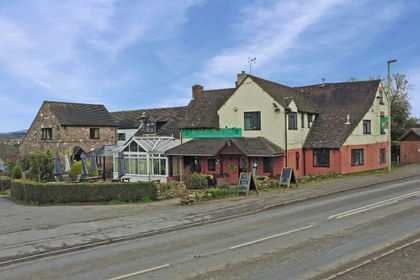
- Price
- Offers in Region of£975,000
- Size
- 0.7 acres
Chelmarsh, Bridgnorth WV16, Chelmarsh, Shropshire WV16 England
Added on 28/01/2026Pub
- Price
- Guide Price£650,000
- Size
- 64.71 acres
Added on 02/07/2026Equestrian property