Carts Bog Inn, Langley-on-Tyne, Hexham, NE47
- Use Class
- Use Class: Sui Generis
Key Features
- Beautiful North Pennines location
- Detached freehold property
- Main bar & games room (30)
- 2-section seating area (46)
- Two bedroom owners accommodation
- Sizeable trade garden & car park
Description
Location:
Langley-on-Tyne is a small hamlet in Northumberland, situated in the North Pennines Area of Outstanding Natural Beauty. Langley, as it also known, is located approximately eight miles west of Hexham and three miles south of Haydon Bridge and the River South Tyne.
The area is popular with tourists who enjoy its many attractions including Langley Castle, a Grade I listed medieval tower house, and National Trust Allen Banks & Staward Gorge, 194 acres of ancient woodland and Victorian gardens in a gorge of the River Allen. The ruins of Staward Peel, a medieval peel tower, stand on a promontory above the gorge. Northumberland National Park, Hadrian’s Wall, The Lake District and the historic towns of Carlisle and Hexham are also easily accessible from Langley.
Langley lies on the A686 which connects Alston in the south to the A69 in the north. The latter provides access to the national motorway network.
The Property
The Carts Bog Inn is a detached, stone property over two storeys to the main, under a pitched slate roof. The property dates back to 1775 and was originally built as a coaching inn. The name ‘Carts Bog’ is believed to have come about as a consequence of the carts carrying minerals from Alston Moor’s lead and silver mines getting stuck in local bogs. The coaching inn was opened to offer the carters warmth and a hearty meal.
The property is beautifully appointed throughout and has stunning, panoramic country views. It briefly comprises:
Property:
GROUND FLOOR
MAIN BAR with a central, wood constructed BAR SERVERY which is well equipped with a wooden back bar and Altro flooring. The trade areas have carpet flooring, exposed ceiling timbers and an interconnecting brick fireplace with coal fire. The bar has seating for 20.
GAMES ROOM with carpet flooring, wood panelled walls, a darts throw and a pool table. The games room has seating for 10.
DINING AREA with loose and fixed bench seating for 26. Serving hatch off the main bar. Exposed brick walls and an interconnecting fireplace. The UPPER SEATING AREA (an old byre) has carpet flooring, exposed ceiling timbers and beams, decorative beer kegs, exposed stone walls and seating for 20.
LADIES’ & GENTLEMEN’S TOILETS.
Good sized KITCHEN, fully equipped with appliances and effects. Separate store/refrigeration room. On level CELLAR and large storeroom.
Owners’ Accommodation
FIRST FLOOR
KITCHEN/DINING AREA. SITTING ROOM with brick fireplace and dual aspect windows. MASTER BEDROOM. DOUBLE BEDROOM. SHOWER ROOM.
External
Enclosed/gated BEER GARDEN with picnic style benches for 50+. Private driveway for three vehicles. Sizeable CAR PARK to the front of the building to accommodate approximately 30 vehicles.
Licence:
A Premises Licence is held for the retail of alcohol. Current opening hours:
Monday and Tuesday – closed
Wednesday and Thursday – 6pm to 10pm
Friday 5pm to 10pm
Saturday 12 noon to 10pm
Sunder 12 noon to 6pm
Services:
Mains electricity, spring water supply and septic tank drainage.
LPG gas for kitchen. Oil-fired central heating.
Rateable Value: £11,250 as at 1st April 2026.
Local Authority: Northumberland County Council.
Business:
The Carts Bog Inn is a traditional country pub with a relaxed atmosphere in a stunning, rural location. It is renowned throughout the region for its fine food which is locally sourced; its ‘Bog Pie’ and its Sunday roasts are firm favourites with locals and visitors alike.
The public house is popular with tourists visiting the area’s attractions and is well supported by the local community. It hosts local farming events, festivals (including Bogfest) and also accommodates wedding receptions. The business offers potential for increased sales through the introduction of glamping/camping and by offering the current owners’ accommodation as a holiday let (subject to the relevant planning permissions). The business has its own website
No trading information is available and prospective purchasers will need to reach their own conclusions as to the potential trade and profitability which can be enjoyed at this outlet.
Map Location
Property details
- Tenure
- Freehold
- Council Tax Band
- Ask Agent
- Date Posted
- 2026-07-17
Utilities & Restrictions
Utilities
- Electricity
- Ask Agent
- Water
- Ask Agent
- Heating
- Ask Agent
- Broadband
- Ask Agent
- Sewerage
- Ask Agent
Rights & Restrictions
- Public Rights of Way
- Ask Agent
- Private Rights of Way
- Ask Agent
- Listed Property
- Ask Agent
- Restrictions
- Ask Agent
Listed status, conservation areas and planning constraints for this location are in the full report.
Property Features
- Accessibility
- Ask Agent
- Parking
- Ask Agent
- Garden
- Ask Agent
Beyond the particulars: planning activity, flood history, heritage and ground risks, checked for this exact spot.
Connectivity
Broadband
Fastest speed available at this postcode
1 Gbps
Gigabit full fibre
Suitable for
- 4K streaming on every screen
- Full-time home working
- Online gaming & big downloads
Mobile signal
Outdoor predictions; indoor signal depends on building materials.
Ofcom Connected Nations postcode-level predictions. Speeds and signal are modelled, not measured, and vary between addresses and providers.
Signal is the easy part. Planning activity, flood history and protected designations here are in the full report.
Nearest Schools
Primary
- Shaftoe Trust Academy2.7 milesOfsted: Good
- Ages
- 3 to 11
- Pupils
- 102
- Type
- Academy sponsor led
- Whitfield CofE Primary School2.9 milesOfsted report card · Jan 2026
- Ages
- 3 to 11
- Pupils
- 22
- Type
- Academy sponsor led
- Faith
- Church of England
- Allendale Primary School3.2 milesNo Ofsted rating
- Ages
- 2 to 11
- Pupils
- 126
- Type
- Community school
- Henshaw Church of England Primary School4.1 milesOfsted: Good
- Ages
- 4 to 11
- Pupils
- 86
- Type
- Academy converter
- Faith
- Church of England
- Newbrough Church of England Primary School5.9 milesOfsted report card · Mar 2026
- Ages
- 2 to 11
- Pupils
- 65
- Type
- Academy converter
- Faith
- Church of England
Secondary
- Haydon Bridge High School2.8 milesOfsted report card · Jan 2026
- Ages
- 11 to 18
- Pupils
- 392
- Type
- Foundation school
- St Joseph's Catholic Middle School, Hexham7 milesNo Ofsted rating
- Ages
- 9 to 13
- Pupils
- 168
- Type
- Academy converter
- Faith
- Roman Catholic
- Queen Elizabeth High School7 milesOfsted: Good
- Ages
- 13 to 18
- Pupils
- 1,299
- Type
- Academy converter
- Hexham Middle School7.7 milesNo Ofsted rating
- Ages
- 9 to 13
- Pupils
- 619
- Type
- Academy converter
- Corbridge Middle School11 milesOfsted report card · Feb 2026
- Ages
- 9 to 13
- Pupils
- 367
- Type
- Community school
Distances are straight-line from the advertised location. Source: the national school registers (DfE, Welsh Government, Scottish Government) and Ofsted.
Schools are just the start: sold prices nearby, planning activity and any flood history are in the full report.
Amenities
Supermarket
GP surgery
Pharmacy
Hospital
Straight-line distances from the advertised location. Sources: NHS records, Geolytix supermarket locations, OS Open Greenspace and the national trails registers.
The area stacks up? Now check the location itself: planning nearby, protected designations and past flooding.
Getting Around
Nearest station
Nearest bus stop
Typical drive times
Straight-line distances from the advertised location; drive times are typical free-flow times over OpenStreetMap road data, so allow more at peak. Public transport locations from DfT NaPTAN.
Easy to reach matters. So do planning activity, flood history and ground risks: all in the full report.
Flood Risk
From Environment Agency flood map open data, checked around the advertised map pin and allowing for the listed acreage where known. This summary comes from LandSale, the advertising platform, not from the listing agent, and is not part of the agent's particulars. Risk can vary across a single holding, so verify anything critical through your own searches before committing.
Rivers and the sea
Surface water
The detail behind these bandings
The full report pinpoints where this location sits on the flood maps, and runs the deeper checks that usually only surface after an offer.
- Exact flood zones & annual chances (included in the full report)
- Any recorded past flooding (included in the full report)
- Planning activity nearby (included in the full report)
- Heritage & conservation (included in the full report)
- Protected nature designations (included in the full report)
- Ground risks (included in the full report)
- Sold prices nearby (included in the full report)
£14.99 · one-off purchase
By LandSale, the platform. Not provided by the listing agent. Ready in about a minute.
Important notice: Information, maps and tags on this page are drawn from the advertising agent's marketing materials or generated automatically. LandSale has not verified them. Relying on these details is at your own risk, always carry out independent checks before committing to a purchase.
LandSale full disclaimer
Marketing information only - not formal particulars. The details on this website are provided for general guidance and do not constitute an offer or contract. Neither LandSale nor the advertising estate/land agent accepts responsibility for any inaccuracy.
1. Source of information
- Listing content: Core description, asking price, tenure, measurements, photographs and planning history originate from the marketing materials of the advertising estate or land agent. LandSale does not author this content and cannot guarantee its accuracy.
- Automated tags & categorisation: Property type, land-use class, acreage bands and similar labels may be applied by machine-learning models. They are intended as a helpful guide only and may not reflect the property's legal status or permitted use.
- Third-party & enriched data layers: Maps, boundary outlines, planning designations, soil reports, broadband coverage and other environmental or location-based insights are licensed from external suppliers. Such data are supplied “as is", may be incomplete or out of date and are subject to change without notice.
2. Verification required
Prospective purchasers must verify critical matters, including but not limited to planning permission, title boundaries, public rights of way, environmental constraints, acreage, services, access and VAT status, through their own inspections, specialist surveys, legal advisers and the selling agent before relying on the information or entering into any contract.
3. No warranty or liability
LandSale gives no warranty, express or implied, as to the accuracy, completeness or fitness for any particular purpose of the information displayed. LandSale shall not be liable for any loss, damage, cost or expense arising directly or indirectly from any use of or reliance on such information, save where liability may not be excluded by law.
4. Updates & feedback
If you believe any detail on this listing is inaccurate, please let us know. We will investigate and, where appropriate, update the listing or notify the agent.
© LandSale | Version 1.3 - August 2026
Listing agent
Sidney Phillips Limited, Northern
Northern
Similar properties for sale
 Added on 29/01/2026Pub
- Price
- £550,000
Black Swan, Culgaith, Penrith, Cumbria, CA10, Culgaith, Westmorland and Furness CA10 England
Added on 29/01/2026Commercial Land
- Price
- Guide Price£500,000
- Size
- 3.23 acres
The Old Tile Works, Culgaith, Penrith, Cumbria CA10, Culgaith, Westmorland and Furness CA10 England
Added on 17/07/2026Commercial Land
- Price
- £450,000
- Size
- 0.09 acres
Border City Autos, Robert Street, Carlisle, Cumberland, Carlisle, Cumberland CA2 England
Added on 17/07/2026Commercial Land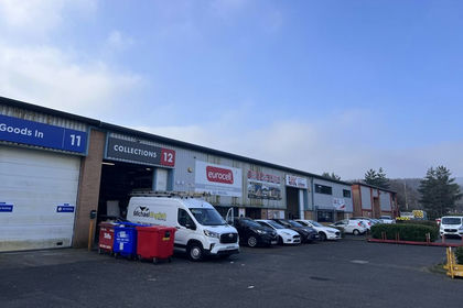
- Price
- £380,000
12, Octavian Way, Team Valley Trading Estate, Gateshead, NE11, Lamesley, Gateshead NE11 England
Added on 12/06/2026Warehouse
- Price
- Offers in Excess of£500,000
- Size
- 0.26 acres
Added on 08/08/2026Warehouse
- Price
- Offers in Excess of£375,000
Added on 29/01/2026Commercial Land Added on 17/07/2026Commercial Land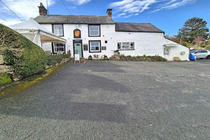
- Price
- £425,000
Added on 17/07/2026Pub
- Price
- £389,000
- Size
- 0.12 acres
Added on 17/07/2026Industrial Land