Land at High Plumgarths, Crook Road, LA8
- Land size
- 7.73 acres
Key Features
- 3.13 Hectares/7.73 acres of proposed commercial development land
- Allocated in the Lake District National Park Local Plan for employment use
- Excellent location, adjacent to the A591 Plumgarths Roundabout, 9 miles from Junction 36 of the M6 and just 1 mile from Kendal town centre
- A unique opportunity in the Lake District National Park, surrounded by parkland landscape
- Expressions of Interest Invited
Description
This is a very rare opportunity to purchase allocated commercial development land within the south area of the Lake District National Park, just 1 mile from Kendal, 7 miles from Windermere with good access to the local and national road network. Extending to 7.73 acres, the land at High Plumgarths will appeal to developers and/or owner occupiers looking to create a high quality scheme, sympathetic to the site?s rural backdrop and where there is a distinct lack of supply of both commercial development opportunities and properties.
LOCATION
The land is situated adjacent to Crook Road in an area known as High Plumgarths within the south boundaries of The Lake District National Park, 1 mile from Kendal, in South Cumbria and in the North West of England.
Kendal is the principal town of South Lakeland and is situated just outside of the southern boundary of the Lake District National Park only 6 miles from Junctions 36 and 37 of the M6 Motorway. The town has a resident population of 29,495 (2011 Census) and is a popular tourist destination being 10 miles south of Windermere. The town has a weighted retail catchment in excess of 50,000 people and a greater district catchment in excess of 102,000. The district?s Class Grouping indicates that in excess of 50% of the catchment area is of A, B or C demographic.
Kendal is a desirable location to live and work enjoying close proximity to the Lake District National Park, Yorkshire Dales National Park as well as a number of Areas of Outstanding Natural Beauty. The town benefits from good primary and secondary schools, colleges and local employers including Anord Mardix, Gilkes, Kendal Nutricare, Metroplan, Furmanite International, Lakeland and James Cropper Plc in the nearby village of Burneside.
Oxenholme Train Station which is situated on the West Coast main railway line is located 5 miles to the southeast providing direct services to London (approximate journey time 2 hours 50 minutes), Birmingham (2 hours, 22 minutes) and Glasgow (1 hour 45 minutes). The nearest city is Lancaster, 22 miles to the south on the M6, Penrith is 25 miles to the north and Carlisle which is the only city in Cumbria is 43 miles to the north.
High Plumgarths is an attractive hamlet located off the A591 and Plumgarths Roundabout made up of a popular public house and restaurant, Lakeland Food Park, which is development of local independent food producers, retailers and businesses, Cumbria Wildlife Trust Head Office as well as a small number of houses. The B5284 Crook Road is the main route into the Lyth Valley to the west and which makes up much of the southeast area of the Lake District National Park, characterised by Lakeland Fells, vast open countryside, high quality hotels and restaurants and leads up to the east shores of Lake Windermere as well as Bowness-on-Windermere, around 8 miles away.
Travelling south, the A591 provides a direct route to Junction 36 of the M6,9 miles away or north through the popular villages of Burneside and Staveley arriving at Windermere, circa 8 miles away and travelling on north to Ambleside, 15 miles away.
DESCRIPTION
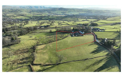
Currently a single field enclosure of permanent pasture as well as a farm steading with a range of agricultural buildings, the site takes access from its southeast corner off Crook Road and extends to the northwest and north taking in part of a section of parkland.
The land, which totals approximately 3.13 hectares (7.73 acres), is included in the Lake District National Park Local Plan Land Allocations adopted May 2021. One of only a few allocated opportunities, the site, known as Land at High Plumgarths (Local Plan Reference: CSE02E) is stated as suitable for employment use and encompasses the existing steading with part of the field and parkland around it.
Part of the site also benefits from an implemented planning consent for the conversion of some of the farm buildings as well as new build B1 offices to provide 8 No. units and around 13,000 sq ft. A copy of the approval and plans can be viewed in the Planning Application Section of the Lake District National Park Website Reference: 7/2006/5447. The approval was implemented by the widening of the access road which is confirmed and documented in writing.
Local Planning Authority ? Lake District National Park Authority, Wayfaring House, Murley Moss Business Park, Oxenholme Road, Kendal LA9 7RL.
LOCAL COMMERICAL MARKET
The commercial property market in South Lakeland is generally characterised as being buoyant, particularly in the warehouse sector but has a limited supply of stock and development land with strong demand. The office market is also influenced by a lack of modern buildings meaning demand is often opportunity-led and there has been very little speculative development in recent years owing to very few sites being available.
Kendal has the largest commercial market in South Lakeland with several business parks and estates developed in the 1980s-early 2000s as well as redevelopment and conversions of older factory sites, strengthened by the location and access to the M6, and the nearby Oxenholme train station. Most of the existing estates are situated centrally around the town where void levels are low both for warehouse and office properties and demand comes from local and inward investment businesses. Market sentiment suggests that a new commercial estate on the outskirts would be attractive to a number of existing occupiers as well as new entrants to Kendal.
SERVICES
Services are thought to be situated in the adjacent Crook Road ? prospective purchasers should satisfy themselves as to the availability of the services and connection to them in consultation with the utility providers.
SITE CONDITIONS
The purchaser will be responsible for the assessment of the ground conditions and will need to satisfy themselves that development can take place safely.
TENURE
Freehold with vacant possession.
METHOD OF SALE
The site is offered for sale as a whole with vacant possession by private treaty. The sellers reserve the right to sell privately and are not bound to accept the highest or any offer received.
Expressions of interest are offered and should be made to the Kendal office of Edwin Thompson, F.A.O. John Haley.
VALUE ADDED TAX
The land is not elected for VAT and therefore VAT will not be payable on the sale consideration.
BOUNDARIES
The purchaser will be responsible for the maintenance of boundaries where required.
SALE PLAN AND PARTICULARS
The sale plan is based on the Ordnance Survey sheet. Prospective purchasers should check the contract documents. The Purchaser shall raise no objection or query in respect of any variation between the physical boundaries and the Ordnance Survey sheet plan. The plans are strictly for identification purposes only.
MONEY LAUNDERING LEGISLATION
Edwin Thompson are bound to comply with Anti-money Laundering legislation including obtaining evidence of the identity and proof of address of potential buyers. Prior to an offer being accepted, interested parties will need to provide the requested evidence as well as proof of funds.
EASEMENTS, WAYLEAVES AND RIGHTS OF WAY
The land is sold subject to and with the benefit of all public and private rights of way, lights, drainage, cable, pylons or other easements, restrictions or obligations whether or not the same are described in these particulars of sale.
VIEWING
The land can be viewed at a reasonable time without prior appointment and when undertaking an inspection, prospective purchasers should have a copy of these sales details to hand.
IMPORTANT NOTICE
Edwin Thompson for themselves and for the Vendor of this property, whose Agents they are, give notice that:
1. The particulars are set out as a general outline only for the guidance of intending purchasers and do not constitute, nor constitute part of, any offer or contract.
2. All descriptions, dimensions, plans, reference to condition and necessary conditions for use and occupation and other details are given in good faith and are believed to be correct, but any intending purchasers should not rely on them as statements or representations of fact, but must satisfy themselves by inspection or otherwise as to their correctness.
3. No person in the employment of Edwin Thompson has any authority to make or give any representation or warranty whatsoever in relation to this property or these particulars, nor to enter into any contract relating to the property on behalf of the Agents, nor into any contract on behalf of the Vendor.
4. No responsibility can be accepted for loss or expense incurred in viewing the property or in any other way in the event of the property being sold or withdrawn.
5. These particulars were prepared in February 2025.
Map Location
Property details
- Tenure
- Ask Agent
- Council Tax Band
- Ask Agent
- Date Posted
- 2026-07-17
Utilities & Restrictions
Utilities
- Electricity
- Ask Agent
- Water
- Ask Agent
- Heating
- Ask Agent
- Broadband
- Ask Agent
- Sewerage
- Ask Agent
Rights & Restrictions
- Public Rights of Way
- Ask Agent
- Private Rights of Way
- Ask Agent
- Listed Property
- Ask Agent
- Restrictions
- Ask Agent
Listed status, conservation areas and planning constraints for this location are in the full report.
Property Features
- Accessibility
- Ask Agent
- Parking
- Ask Agent
- Garden
- Ask Agent
Beyond the particulars: planning activity, flood history, heritage and ground risks, checked for this exact spot.
Connectivity
Broadband
Fastest speed available at this postcode
1 Gbps
Gigabit full fibre
Suitable for
- 4K streaming on every screen
- Full-time home working
- Online gaming & big downloads
Fixed wireless access may also be an option here.
Mobile signal
Outdoor predictions; indoor signal depends on building materials.
Ofcom Connected Nations postcode-level predictions. Speeds and signal are modelled, not measured, and vary between addresses and providers.
Signal is the easy part. Planning activity, flood history and protected designations here are in the full report.
Nearest Schools
Primary
- St Oswald's CofE Primary School0.8 milesNo Ofsted rating
- Ages
- 2 to 11
- Pupils
- 88
- Type
- Voluntary aided school
- Faith
- Church of England
- St Thomas's CofE Primary School1.1 milesOfsted: Good *
- Ages
- 3 to 11
- Pupils
- 239
- Type
- Voluntary aided school
- Faith
- Church of England
- Stramongate Primary School1.7 milesOfsted: Good *
- Ages
- 4 to 11
- Pupils
- 237
- Type
- Academy converter
- Ghyllside Primary School1.8 milesOfsted: Requires improvement *
- Ages
- 3 to 11
- Pupils
- 424
- Type
- Academy converter
- Vicarage Park CofE Primary School2.2 milesNo Ofsted rating
- Ages
- 4 to 11
- Pupils
- 109
- Type
- Voluntary controlled school
- Faith
- Church of England
Secondary
- The Queen Katherine School1.7 milesOfsted report card · May 2026
- Ages
- 11 to 19
- Pupils
- 910
- Type
- Academy converter
- Kirkbie Kendal School2.4 milesNo Ofsted rating
- Ages
- 11 to 18
- Pupils
- 1,029
- Type
- Academy converter
- The Lakes School6.7 milesOfsted: Good
- Ages
- 11 to 18
- Pupils
- 445
- Type
- Community school
- Dallam School8.1 milesOfsted report card · Apr 2026
- Ages
- 11 to 18
- Pupils
- 761
- Type
- Academy converter
- Settlebeck School10 milesOfsted: Good *
- Ages
- 11 to 16
- Pupils
- 203
- Type
- Academy converter
* Latest graded judgement covers quality of education only; no overall grade was issued under the 2024-25 inspection framework.
Distances are straight-line from the advertised location. Source: the national school registers (DfE, Welsh Government, Scottish Government) and Ofsted.
Schools are just the start: sold prices nearby, planning activity and any flood history are in the full report.
Amenities
Supermarket
GP surgery
Pharmacy
Hospital
Green space
Straight-line distances from the advertised location. Sources: NHS records, Geolytix supermarket locations, OS Open Greenspace and the national trails registers.
The area stacks up? Now check the location itself: planning nearby, protected designations and past flooding.
Getting Around
Nearest station
Nearest bus stop
Typical drive times
Straight-line distances from the advertised location; drive times are typical free-flow times over OpenStreetMap road data, so allow more at peak. Public transport locations from DfT NaPTAN.
Easy to reach matters. So do planning activity, flood history and ground risks: all in the full report.
Flood Risk
From Environment Agency flood map open data, checked around the advertised map pin and allowing for the listed acreage where known. This summary comes from LandSale, the advertising platform, not from the listing agent, and is not part of the agent's particulars. Risk can vary across a single holding, so verify anything critical through your own searches before committing.
Rivers and the sea
Surface water
Mapped within the area searched, not at the advertised map pin itself.
The detail behind these bandings
The full report pinpoints where this location sits on the flood maps, and runs the deeper checks that usually only surface after an offer.
- Exact flood zones & annual chances (included in the full report)
- Any recorded past flooding (included in the full report)
- Planning activity nearby (included in the full report)
- Heritage & conservation (included in the full report)
- Protected nature designations (included in the full report)
- Ground risks (included in the full report)
- Sold prices nearby (included in the full report)
£14.99 · one-off purchase
By LandSale, the platform. Not provided by the listing agent. Ready in about a minute.
Important notice: Information, maps and tags on this page are drawn from the advertising agent's marketing materials or generated automatically. LandSale has not verified them. Relying on these details is at your own risk, always carry out independent checks before committing to a purchase.
LandSale full disclaimer
Marketing information only - not formal particulars. The details on this website are provided for general guidance and do not constitute an offer or contract. Neither LandSale nor the advertising estate/land agent accepts responsibility for any inaccuracy.
1. Source of information
- Listing content: Core description, asking price, tenure, measurements, photographs and planning history originate from the marketing materials of the advertising estate or land agent. LandSale does not author this content and cannot guarantee its accuracy.
- Automated tags & categorisation: Property type, land-use class, acreage bands and similar labels may be applied by machine-learning models. They are intended as a helpful guide only and may not reflect the property's legal status or permitted use.
- Third-party & enriched data layers: Maps, boundary outlines, planning designations, soil reports, broadband coverage and other environmental or location-based insights are licensed from external suppliers. Such data are supplied “as is", may be incomplete or out of date and are subject to change without notice.
2. Verification required
Prospective purchasers must verify critical matters, including but not limited to planning permission, title boundaries, public rights of way, environmental constraints, acreage, services, access and VAT status, through their own inspections, specialist surveys, legal advisers and the selling agent before relying on the information or entering into any contract.
3. No warranty or liability
LandSale gives no warranty, express or implied, as to the accuracy, completeness or fitness for any particular purpose of the information displayed. LandSale shall not be liable for any loss, damage, cost or expense arising directly or indirectly from any use of or reliance on such information, save where liability may not be excluded by law.
4. Updates & feedback
If you believe any detail on this listing is inaccurate, please let us know. We will investigate and, where appropriate, update the listing or notify the agent.
© LandSale | Version 1.3 - August 2026
Listing agent
EDWIN THOMPSON PROPERTY SERVICES LIMITED, Kendal
Contact EDWIN THOMPSON PROPERTY SERVICES LIMITED, Kendal
View agent profileSimilar properties for sale
- Price
- POA
- Size
- 7.73 acres
Land at High Plumgarths, Crook Road, LA8, Strickland Ketel, Westmorland and Furness LA8 England
Added on 17/07/2026Development Land
- Price
- Guide Price£155,000
- Size
- 23.94 acres
Land at Crook, Kendal, LA8, Crook, Westmorland and Furness LA8 England
Added on 17/07/2026Farmland
- Price
- £2,750,000
- Size
- 47 acres
Yew Tree Farm, Crook, Kendal, LA8, Crook, Westmorland and Furness LA8 England
Added on 24/07/2026Farmland
- Price
- Offers Over£725,000
- Size
- 162.12 acres
Added on 04/02/2026Grazing Land
- Price
- Guide Price£120,000
- Size
- 7.14 acres
Added on 16/07/2026Agricultural Land
- Price
- Offers Over£550,000
- Size
- 136.35 acres
Added on 04/02/2026Grazing Land
- Price
- Offers in Region of£130,000
- Size
- 5.34 acres
Selside, Kendal, Cumbria, Selside and Fawcett Forest, Westmorland and Furness LA8 England
Added on 31/07/2026Barn
- Price
- Offers Over£750,000
- Size
- 129.9 acres
Bretherdale Woodland, Orton, Westmorland and Furness CA10 England
Added on 29/01/2026Timberland
- Price
- Offers Over£50,000
- Size
- 6.21 acres
Sedbergh, Cumbria, Sedbergh, Westmorland and Furness LA10 England
Added on 18/08/2026Agricultural Land
- Price
- Guide Price£430,000
- Size
- 29.5 acres
Lot 3 - Brockholes Farm, Tebay, CA10, Tebay, Westmorland and Furness CA10 England
Added on 09/06/2026Farmland