Blagdon Road, Paignton
- Land size
- 1 acres
- Bedrooms
- 4
- Bathrooms
- 2
Key Features
- Character Property
- Four Double Bedrooms
- Grade II Listed
- Large Driveway and Electric Double Garage
- Sits on Approximately an Acre Plot
- Wood Burners
- Detached Property
- Large Front and Rear Garden
- Original Features Preserved
- Electric Gated Entrance
Description
Luscombe Maye are delighted to bring to market an exceptional detached four bedroom character property, situated 10 minutes from Totnes. This outstanding property is positioned within a generous plot of approximately one acre, seamlessly blending period charm with modern contemporary living, retaining a range of original features, creating a truly inviting and stylish residence.
Upon entering the property you are welcomed into the spacious entrance hallway, characterised by high ceilings and beautifully preserved original features. To the left, the recently renovated sitting room is finished to an exceptional standard, and centred around a charming wood burner, creating a striking focal point. The room is further enhanced by a large front-facing bay window spanning the width of the wall, allowing natural light to flood the space while offering idyllic views over the surrounding woodland, perfect for a relaxing setting. Opposite, to the right of the hallway, is a peaceful study, completed with an attractive fireplace and wood burner. Large sash windows fill the room with natural light, making it an ideal environment for working from home or quiet retreat. At the heart of the property lies a grand dining room, accessed via dual entrances, showcasing an original marble fireplace. This elegant room also benefits from the large bay window, enjoying tranquil views across the garden and woodland beyond, creating a wonderful setting for both everyday dining and entertaining. Adjacent is the kitchen, fitted with modern wall and base units providing generous storage and ample worksurface space. A central island adds both practicality and sociability, making it an ideal hub for family life and entertaining guests. To the rear of the property is an additional reception room/snug with dual aspect, offering a versatile space perfect for relaxation or hobbies. The ground floor is completed by a convenient downstairs WC located off the entrance hall, along with a useful utility room at the rear.
Downstairs there is the original cellar that has 2 large storage rooms and a cinema that is in the process of being renovated.
Ascending the main staircase, a striking arched window floods the spacious landing with natural light, from which the thoughtfully arranged accommodation unfolds. The master bedroom features an elegant fireplace and large windows allowing natural light to fill the room, creating a bright and inviting atmosphere. This leads seamlessly into the beautifully renovated dressing room, complete with ample fitted storage and further into the generous ensuite bathroom. This en-suite is superbly appointed with a walk-in shower, free standing bath, WC and handbasin, and also provides convenient access back to the main landing. Along the hallway are two further well-proportioned double bedrooms, each benefiting from high ceiling and delightful views over the lawned gardens and surrounding woodland. Continuing along the corridor, the former 'housekeepers' wings offers additional accommodation including another spacious double bedroom served by a family bathroom, fitted with a walk-in shower, free-standing bath, WC and hand basin.
Externally the property is set within beautifully maintained, expansive grounds, with sweeping lawns from the electric gated entrance into surrounding woodland creating an outstanding tranquil and private setting. The rear garden features a patio area, ideal for alfresco dining and outdoor relaxation. Approached via a driveway that winds through the picturesque woodland garden, the property opens onto a generous forecourt providing ample parking for multiple vehicles, along with a electrically operated double garage
PAIGNTON
Paignton is a seaside town on the coast of Torbay. Together with Torquay and Brixham it forms the borough of Torbay. The Torbay area is a holiday destination known as the English Riviera. Paignton has origins as a Celtic settlement and was first mentioned in 1086. It grew as a small fishing village and a new harbour was built in 1847. A railway line was opened to passengers in 1859 creating links to Torquay and London . Paignton is around 25 miles north east of Plymouth and 20 miles south of Exeter. There are nearby beaches and one of the UK's biggest Zoos, Paignton Zoo, UK's largest outdoor waterpark and steam railway. The stunning South West Coast Path stretches for miles in both directions so walkers can enjoy the wonderful scenery and breath-taking views all the way to Brixham and Torquay. The unique and charming market town of Totnes is only 7 miles away which sits above the River Dart in the heart of the South Hams. It has a twice weekly market and full of small independent shops, it is well known for ethical products, wholefoods and fair trade goods. It is the second oldest borough in England, with an ancient Guildhall and Church, a Norman Castle and its North and East Gates. There is a well regarded Community College and a mainline railway station and Dartmoor, the South Hams and many of its fine beaches are within easy reach.
FURTHER INFORMATION
To ensure legal compliance, we require our sellers to complete a Property Information Questionnaire or provide a Material Information Guide along with the title document. If available, please scan the QR code or access the additional online material information ( ) . Alternatively, you can contact our team for this information.
Verified Material Information
Costs and tenure
Tenure: Freehold
Council tax band: G
EPC rating: D
The building
Detached house, standard brick and block construction, Heavitree Stone: A specific, coarse red breccia stone uniquely used in older Victorian buildings in and around Exeter, Devon
4 bedrooms, 2 bathrooms, 1 reception
Accessibility adaptations: None
Loft: insulated and boarded, accessed by By ladder
Outside areas: Front garden and Rear garden
No spray foam insulation
Services
Mains electricity
Mains water
Foul drainage: Septic tank
No mains surface water drainage
Mains gas central heating, installed 27th Jan 2016
Broadband: FTTP (Fibre to the Premises)
Mobile coverage: O2 good, Vodafone good, Three good, EE good
Parking: Garage, Driveway, Gated, Off Street, and Private
Not in a controlled parking zone
No disabled parking available
Risks and restrictions
Grade II listed building — THE OLD VICARAGE (Historic England NHLE list entry 1207529). See
Not in a conservation area
Tree preservation order present
Title register restrictions (DN138512):
- The owner cannot use a name for the house that suggests it is still the official home of the local vicar.
- The property cannot be used as a hotel, pub, or place of entertainment, and the sale of alcohol is prohibited.
- The owner must not do anything that causes a nuisance or annoyance to the local vicar or the people attending services at the nearby Parish Church.
- The owner is not allowed to object to the ringing of the church bells at the neighbouring Parish Church.
- The owner must ensure the wall between the property and the churchyard remains closed where a pedestrian gate was previously located.
Non-coal mining area: yes
Planning application: The field next to us has planning permission granted, but nothing has been carried out.
No specialist issues recorded
Onward chain: no
All information is provided without warranty. Contains HM Land Registry data © Crown copyright and database right 2021. This data is licensed under the Open Government Licence v3.0.
The information contained is intended to help you decide whether the property is suitable for you. You should verify any answers which are important to you with your property lawyer or surveyor or ask for quotes from the appropriate trade experts: builder, plumber, electrician, damp, and timber expert.
LETTINGS
Luscombe Maye also offers an Award Winning Lettings service. If you are considering Letting your own property, or a buy to let purchase, please inform us and we can put you in contact with the Lettings team who would be delighted to discuss our range of bespoke services with you.
VIEWINGS
By appointment with Luscombe Maye, Totnes
DIRECTIONS
What3Words - period.bossy.zeal
Map Location
Property details
- Tenure
- Freehold
- Council Tax Band
- G
- Date Posted
- 2026-07-14
Market Value Analysis
Compared with 1,624 Homes with Land listings in South West England (1+ acres).
Energy Performance Certificate
Energy Efficiency Rating
Based on UK Energy Performance Certificate standards (EU Directive 2002/91/EC)
Running costs are one side. Planning activity, flood history and ground risks for this location are in the full report.
Utilities & Restrictions
Utilities
- Electricity
- Mains
- Water
- Mains
- Heating
- Gas Heating, Gas Central Heating
- Broadband
- Full Fibre (FTTP)
- Sewerage
- Septic Tank / Private
Rights & Restrictions
- Public Rights of Way
- Ask Agent
- Private Rights of Way
- Ask Agent
- Listed Property
- Yes
- Restrictions
- Ask Agent
Listed status, conservation areas and planning constraints for this location are in the full report.
Property Features
- Accessibility
- Ask Agent
- Parking
- Garage, Driveway, Off-Street Parking, Private Parking
- Garden
- Private Garden
Beyond the particulars: planning activity, flood history, heritage and ground risks, checked for this exact spot.
Connectivity
Broadband
Fastest speed available at this postcode
1.8 Gbps
Gigabit full fibre · available to 57% of premises
Suitable for
- 4K streaming on every screen
- Full-time home working
- Online gaming & big downloads
Mobile signal
Predicted 4G and 5G signal; indoor signal depends on building materials.
Ofcom Connected Nations postcode-level predictions. Speeds and signal are modelled, not measured, and vary between addresses and providers.
Signal is the easy part. Planning activity, flood history and protected designations here are in the full report.
Nearest Schools
Primary
- Collaton St Mary Church of England Primary School145 metresNo Ofsted rating
- Ages
- 4 to 11
- Pupils
- 199
- Type
- Academy converter
- Faith
- Church of England
- Kings Ash Academy0.9 milesOfsted: Good
- Ages
- 2 to 11
- Pupils
- 293
- Type
- Academy converter
- Hayes School1 mileOfsted: Outstanding *
- Ages
- 3 to 11
- Pupils
- 340
- Type
- Academy converter
- Roselands Primary School1.1 milesOfsted: Good
- Ages
- 4 to 11
- Pupils
- 315
- Type
- Academy converter
- St Michael's Church of England Academy1.3 milesOfsted: Good
- Ages
- 2 to 11
- Pupils
- 101
- Type
- Free schools
- Faith
- Church of England
Secondary
- Paignton Academy989 metresOfsted: Requires improvement *
- Ages
- 11 to 16
- Pupils
- 1,568
- Type
- Academy converter
- Churston Ferrers Grammar School Academy3 milesOfsted: Good
- Ages
- 11 to 18
- Pupils
- 1,062
- Type
- Academy converter
- Torquay Boys' Grammar School3.7 milesOfsted report card · Feb 2026
- Ages
- 11 to 18
- Pupils
- 1,087
- Type
- Academy converter
- Gender
- Boys
- Torquay Girls' Grammar School3.8 milesOfsted: Outstanding
- Ages
- 11 to 18
- Pupils
- 1,058
- Type
- Academy converter
- Gender
- Girls
- King Edward VI Community College4.3 milesNo Ofsted rating
- Ages
- 11 to 18
- Pupils
- 940
- Type
- Academy converter
* Latest graded judgement covers quality of education only; no overall grade was issued under the 2024-25 inspection framework.
Distances are straight-line from the advertised location. Source: the national school registers (DfE, Welsh Government, Scottish Government) and Ofsted.
Schools are just the start: sold prices nearby, planning activity and any flood history are in the full report.
Amenities
Supermarket
GP surgery
Pharmacy
Hospital
Green space
Straight-line distances from the advertised location. Sources: NHS records, Geolytix supermarket locations, OS Open Greenspace and the national trails registers.
The area stacks up? Now check the location itself: planning nearby, protected designations and past flooding.
Getting Around
Nearest station
Nearest bus stop
Typical drive times
Straight-line distances from the advertised location; drive times are typical free-flow times over OpenStreetMap road data, so allow more at peak. Public transport locations from DfT NaPTAN.
Easy to reach matters. So do planning activity, flood history and ground risks: all in the full report.
Flood Risk
Environment Agency open data, checked around the advertised map pin for the listed acreage. Long-term risk counts flood defences; the planning map's flood zones do not. Provided by LandSale, not the listing agent, and not part of the agent's particulars. Risk varies across a holding, so verify before committing.
Rivers and the sea
Planning map: Flood Zone 1.
Surface water
These bandings are the summary. Where this location sits on the flood maps, plus planning activity, heritage and ground risks, is in the full report.
Important notice: Information, maps and tags on this page are drawn from the advertising agent's marketing materials or generated automatically. LandSale has not verified them. Relying on these details is at your own risk, always carry out independent checks before committing to a purchase.
LandSale full disclaimer
Marketing information only - not formal particulars. The details on this website are provided for general guidance and do not constitute an offer or contract. Neither LandSale nor the advertising estate/land agent accepts responsibility for any inaccuracy.
1. Source of information
- Listing content: Core description, asking price, tenure, measurements, photographs and planning history originate from the marketing materials of the advertising estate or land agent. LandSale does not author this content and cannot guarantee its accuracy.
- Automated tags & categorisation: Property type, land-use class, acreage bands and similar labels may be applied by machine-learning models. They are intended as a helpful guide only and may not reflect the property's legal status or permitted use.
- Third-party & enriched data layers: Maps, boundary outlines, planning designations, soil reports, broadband coverage and other environmental or location-based insights are licensed from external suppliers. Such data are supplied “as is", may be incomplete or out of date and are subject to change without notice.
2. Verification required
Prospective purchasers must verify critical matters, including but not limited to planning permission, title boundaries, public rights of way, environmental constraints, acreage, services, access and VAT status, through their own inspections, specialist surveys, legal advisers and the selling agent before relying on the information or entering into any contract.
3. No warranty or liability
LandSale gives no warranty, express or implied, as to the accuracy, completeness or fitness for any particular purpose of the information displayed. LandSale shall not be liable for any loss, damage, cost or expense arising directly or indirectly from any use of or reliance on such information, save where liability may not be excluded by law.
4. Updates & feedback
If you believe any detail on this listing is inaccurate, please let us know. We will investigate and, where appropriate, update the listing or notify the agent.
© LandSale | Version 1.3 - August 2026
Similar properties for sale
- Price
- Guide Price£1,000,000
- Size
- 2 acres
Added on 14/08/2026House with Land
- Price
- Guide Price£875,000
Swallow Barns, Higher Well Farm, Stoke Gabriel, Stoke Gabriel, Devon TQ9 England
Added on 11/09/2026Barn Conversion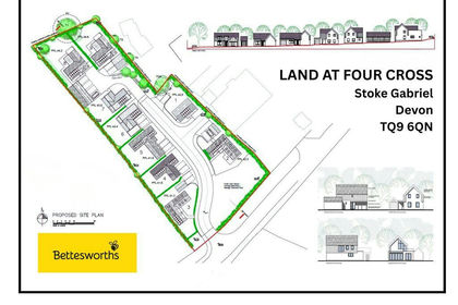
- Price
- Offers in Excess of£1,000,000
Added on 22/05/2026Development Land
- Price
- £900,000
- Size
- 1 acres
Added on 07/07/2026House with Land
- Price
- Guide Price£1,300,000
- Size
- 1.33 acres
The Lane, Dittisham, Dartmouth, Devon, TQ6, Dittisham, Devon TQ6 England
Added on 01/05/2026House with Land
- Price
- £995,000
- Size
- 4.05 acres
Added on 08/09/2026House with Land
- Price
- £1,000,000
- Size
- 0.5 acres
Added on 17/07/2026Development Land
- Price
- Guide Price£1,395,000
- Size
- 28 acres
Wrigwell Farm House, Wrigwell Lane, Ipplepen, Newton Abbot w/ 28 Acres, Ipplepen, Devon TQ12 England
Added on 22/06/2026Farmhouse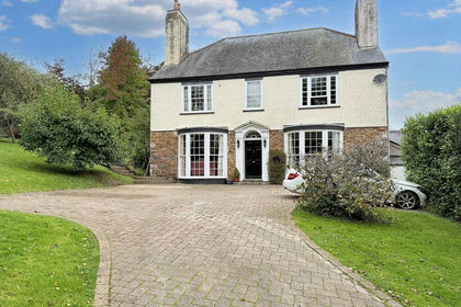
- Price
- Offers in Excess of£1,000,000
- Size
- 1 acres
Added on 18/08/2026Farmhouse
- Price
- Offers in Region of£1,350,000
- Size
- 1.28 acres
Connybeare Lane, Coffinswell, TQ12, Coffinswell, Devon TQ12 England
Added on 18/08/2026House with Land