Southernwood Rise, Folkestone, Kent
- Bedrooms
- 4
- Bathrooms
- 4
Description
The information we have been provided estimates build costs for this home to be in the region of £491,000. With the addition of consultant's fees the total is estimated to be in the region of £577,000. More information and full costing is available on request.
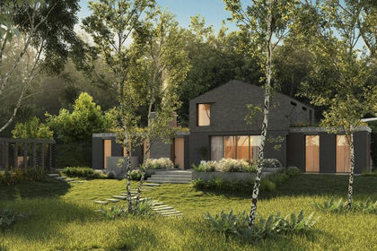
Situated in an elevated position on a leafy cul-de-sac in the wider area of Folkestone, this wonderful plot of land provides an exciting opportunity to build a home within walking distance of the Kentish seaside. Sustainability has been a core consideration of the design and is epitomised by the architect’s approach to light, space and materiality. The house is planned to unfold over 2,385 sq ft, with four bedrooms and open-plan living spaces. Full details of the current planning permission can be found here.
The Tour
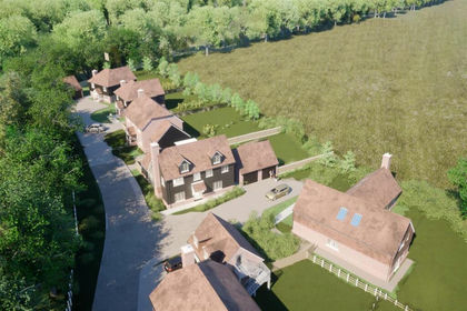
Designed by the architect-owner to Passivhaus standard, the proposed home is intended to blend seamlessly and sensitively with its surrounding landscape. An exceptional attention to detail determines the material palette, while privacy will be guaranteed by a meticulously landscaped garden.
The house will be set back from the road behind a large, private parking area and a screen of mature greenery. A decisively contemporary silhouette, singular for the area, will be defined by dark, Petersen K-series waterstruck brick crowned by a pitched roof, lending a distinct texture and a sense of volume. A quiet, recessive architectural style has been favoured to gently fold into the landscape.
Entrance is planned on the upper floor via a central hallway that opens to two bedrooms and a shared bathroom. One of the bedrooms will benefit from a spacious walk-in wardrobe that stretches across almost the full width of the room, while the bathroom has been thoughtfully designed to incorporate a large walk-in shower.
A staircase will descend from the hallway to a capacious open-plan kitchen-living-dining area. Here, a fully fitted kitchen will be anchored by a central island, lending to a carefully composed sequence of spaces. The garden can be accessed here via sliding doors and down from a rear terrace, lending a wonderfully intimate connection to nature.
Two bedrooms with en suites extend on either side and frame views of the garden, with access out to private patios. The bathrooms present themselves as well-appointed, one with a shower over bath, and the other, a walk-in shower.
A separate utility room and bathroom with a walk-in shower will also sit on this floor, fully equipped and providing additional storage space.
Outdoor Space
At the rear of the house, a considered combination of dark and light Petersen K-series bricks will contrast with the façade, lending a subtle variation in colour and texture. Integration within the landscape has been prioritised: boundary trees and woodland features will be preserved, and a planting scheme based on oak, beech, birch, hazel and hawthorn has been chosen to avoid invasive species.
Shaded terraces and exposed lawned spaces have been devised with utmost care to provide a sense of repose, while planning permission has also been granted for a 38m² enclosed sauna and pool. Particular importance has been placed on planting and biodiversity preservation throughout the scheme.
The Area
This plot lies on the western side of Folkestone, within easy reach of both the coast and the town's flourishing old centre. In recent years, Folkestone has established itself as one of Kent's most coveted coastal destinations, with its independent shops, galleries and restaurants centred around the Harbour Arm and Creative Quarter. The bustling Folkestone Harbour Arm has become a focal point for food, events and sea views, while the nearby Leas promenade and Lower Leas Coastal Park provide miles of gardens, walking routes and access to the beach.
Excellent cafés and restaurants are scattered throughout the town. Local favourites include Steep Street Coffee House, Let’s Amore Sicilian Trattoria, and the British Lion pub, with parts that date back to the 15th century. Independent cafés and restaurants line Sandgate High Street, just a few minutes away.
The surrounding coastline is one of Kent's finest. Walks along the cliffs lead towards Sandgate and Hythe in one direction, or Dover's White Cliffs in the other, while nearby beaches provide opportunities for swimming, paddleboarding and sailing throughout the summer.
Folkestone Central and Folkestone West stations both provide High Speed services to London St Pancras in under an hour, while the M20 provides easy connections to wider destinations.
Map Location
Property details
- Tenure
- Freehold
- Council Tax Band
- Ask Agent
- Date Posted
- 2026-07-11
Utilities & Restrictions
Utilities
- Electricity
- Ask Agent
- Water
- Ask Agent
- Heating
- Ask Agent
- Broadband
- Ask Agent
- Sewerage
- Ask Agent
Rights & Restrictions
- Public Rights of Way
- Ask Agent
- Private Rights of Way
- Ask Agent
- Listed Property
- Ask Agent
- Restrictions
- Ask Agent
Listed status, conservation areas and planning constraints for this location are in the full report.
Property Features
- Accessibility
- Ask Agent
- Parking
- Parking Available
- Garden
- Garden
Beyond the particulars: planning activity, flood history, heritage and ground risks, checked for this exact spot.
Connectivity
Broadband
Fastest speed available at this postcode
1.8 Gbps
Gigabit full fibre
Suitable for
- 4K streaming on every screen
- Full-time home working
- Online gaming & big downloads
Mobile signal
Outdoor predictions; indoor signal depends on building materials.
Ofcom Connected Nations postcode-level predictions. Speeds and signal are modelled, not measured, and vary between addresses and providers.
Signal is the easy part. Planning activity, flood history and protected designations here are in the full report.
Nearest Schools
Primary
- Sandgate Primary School273 metresOfsted report card · Feb 2026
- Ages
- 4 to 11
- Pupils
- 419
- Type
- Community school
- Morehall Primary School and Nursery920 metresOfsted: Good
- Ages
- 2 to 11
- Pupils
- 249
- Type
- Academy sponsor led
- All Soul's Church of England Primary School972 metresOfsted: Good
- Ages
- 4 to 11
- Pupils
- 256
- Type
- Academy converter
- Faith
- Church of England
- Cheriton Primary School0.9 milesOfsted: Good *
- Ages
- 4 to 11
- Pupils
- 391
- Type
- Foundation school
- Harcourt Primary School1 mileOfsted report card · Feb 2026
- Ages
- 4 to 11
- Pupils
- 179
- Type
- Foundation school
Secondary
- The Folkestone School for Girls457 metresOfsted: Good
- Ages
- 11 to 18
- Pupils
- 1,145
- Type
- Academy converter
- Gender
- Girls
- The Harvey Grammar School923 metresNo Ofsted rating
- Ages
- 11 to 18
- Pupils
- 1,005
- Type
- Academy converter
- Gender
- Boys
- Turner Free School0.7 milesOfsted: Good
- Ages
- 11 to 18
- Pupils
- 997
- Type
- Free schools
- Folkestone Academy1.2 milesOfsted report card · May 2026
- Ages
- 11 to 19
- Pupils
- 936
- Type
- Academy sponsor led
- Brockhill Park Performing Arts College3.6 milesOfsted report card · Jan 2026
- Ages
- 11 to 18
- Pupils
- 1,314
- Type
- Academy converter
* Latest graded judgement covers quality of education only; no overall grade was issued under the 2024-25 inspection framework.
Distances are straight-line from the advertised location. Source: the national school registers (DfE, Welsh Government, Scottish Government) and Ofsted.
Schools are just the start: sold prices nearby, planning activity and any flood history are in the full report.
Amenities
Supermarket
GP surgery
Pharmacy
Hospital
Green space
Straight-line distances from the advertised location. Sources: NHS records, Geolytix supermarket locations, OS Open Greenspace and the national trails registers.
The area stacks up? Now check the location itself: planning nearby, protected designations and past flooding.
Getting Around
Nearest station
Nearest bus stop
Typical drive times
Straight-line distances from the advertised location; drive times are typical free-flow times over OpenStreetMap road data, so allow more at peak. Public transport locations from DfT NaPTAN.
Easy to reach matters. So do planning activity, flood history and ground risks: all in the full report.
Flood Risk
From Environment Agency flood map open data, checked around the advertised map pin and allowing for the listed acreage where known. This summary comes from LandSale, the advertising platform, not from the listing agent, and is not part of the agent's particulars. Risk can vary across a single holding, so verify anything critical through your own searches before committing.
Rivers and the sea
Surface water
The detail behind these bandings
The full report pinpoints where this location sits on the flood maps, and runs the deeper checks that usually only surface after an offer.
- Exact flood zones & annual chances (included in the full report)
- Any recorded past flooding (included in the full report)
- Planning activity nearby (included in the full report)
- Heritage & conservation (included in the full report)
- Protected nature designations (included in the full report)
- Ground risks (included in the full report)
- Sold prices nearby (included in the full report)
£14.99 · one-off purchase
By LandSale, the platform. Not provided by the listing agent. Ready in about a minute.
Important notice: Information, maps and tags on this page are drawn from the advertising agent's marketing materials or generated automatically. LandSale has not verified them. Relying on these details is at your own risk, always carry out independent checks before committing to a purchase.
LandSale full disclaimer
Marketing information only - not formal particulars. The details on this website are provided for general guidance and do not constitute an offer or contract. Neither LandSale nor the advertising estate/land agent accepts responsibility for any inaccuracy.
1. Source of information
- Listing content: Core description, asking price, tenure, measurements, photographs and planning history originate from the marketing materials of the advertising estate or land agent. LandSale does not author this content and cannot guarantee its accuracy.
- Automated tags & categorisation: Property type, land-use class, acreage bands and similar labels may be applied by machine-learning models. They are intended as a helpful guide only and may not reflect the property's legal status or permitted use.
- Third-party & enriched data layers: Maps, boundary outlines, planning designations, soil reports, broadband coverage and other environmental or location-based insights are licensed from external suppliers. Such data are supplied “as is", may be incomplete or out of date and are subject to change without notice.
2. Verification required
Prospective purchasers must verify critical matters, including but not limited to planning permission, title boundaries, public rights of way, environmental constraints, acreage, services, access and VAT status, through their own inspections, specialist surveys, legal advisers and the selling agent before relying on the information or entering into any contract.
3. No warranty or liability
LandSale gives no warranty, express or implied, as to the accuracy, completeness or fitness for any particular purpose of the information displayed. LandSale shall not be liable for any loss, damage, cost or expense arising directly or indirectly from any use of or reliance on such information, save where liability may not be excluded by law.
4. Updates & feedback
If you believe any detail on this listing is inaccurate, please let us know. We will investigate and, where appropriate, update the listing or notify the agent.
© LandSale | Version 1.3 - August 2026
Listing agent
The Modern House, London
St Alphege Hall Kings Bench Street London SE1 0QX
Contact The Modern House, London
St Alphege Hall Kings Bench Street London SE1 0QX
View agent profileSimilar properties for sale
- Price
- £220,000
- Size
- 0.33 acres
Southernwood Rise, Folkestone, Kent, CT20, Sandgate, Kent CT20 England
Added on 30/05/2026Undeveloped Land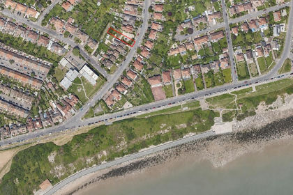 Added on 16/06/2026Building Plot
- Price
- Guide Price£275,000
- Size
- 0.24 acres
Added on 13/05/2026Building Plot
- Price
- Offers in Excess of£200,000
Land to the rear of High Street, New Romney TN28, New Romney, Kent TN28 England
Added on 22/05/2026Development Land
- Price
- £210,000
Added on 27/03/2026Development Land
- Price
- Guide Price£180,000
- Size
- 0.09 acres
Added on 24/06/2026Building Plot Added on 29/01/2026Self Build Plot
- Price
- Guide Price£250,000
- Size
- 0.17 acres
Added on 22/06/2026Development Land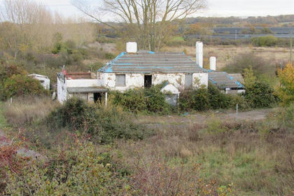 Added on 17/06/2026Redevelopment Land
 Added on 28/01/2026Self Build Plot