Star, Gaerwen, Anglesey, LL60
- Land size
- 22.5 acres
- Bedrooms
- 4
- Bathrooms
- 2
Description
An exciting opportunity to purchase a 22.5 acres smallholding situated in an idyllic location with fabulous views of the Snowdonia Mountain Range.
Cyfle arbennig i brynnu manddaliad 22.5 acer gyda golygfeydd gwych o fynyddoedd Eryri.
Directions
From the A55 expressway exit at Junction 7 signposted Star, continue along the A5 towards Gaerwen. Turn right signposted Star, continue up through Star and turn left directly after the property Awel Môn. Continue along this country lane passing Capel Pencarneddi and Bryn Coch is the next property on your right hand side.
Location
Located on the eastern side of Anglesey in the rural hamlet of Star, between the villages of Gaerwen and Llanfairpwll. Both of these villages offer a small range of amenities including shop, garage, doctor's surgery and primary schools. Llanfairpwll also has a train station with direct service to London Euston. The property is easily accessible to the A55 expressway being within approximately 3 miles of the Britannia crossing of the Menai Straits with the north west coastline and Cheshire. It offers easy access to Bangor University and Ysbyty Gwynedd. Nestled in the heart of the countryside yet being conveniently situated with easy access to the A55 expressway and the mainland.
Description
Bryn Coch occupies a delightful rural position in the heart of the Anglesey countryside, this attractive smallholding offers a rare opportunity to acquire a property with approximately 22.5 acres of land, extensive outbuildings and tremendous potential for a variety of agricultural, equestrian or lifestyle pursuits. Approached via a private driveway and surrounded by open farmland, is in an elevated position with glorious and spectacular panoramic views of the whole of the Snowdonia Mountain Range. The holding comprises a traditional farmhouse, a range of character stone outbuildings and agricultural barn, all set within generous grounds and productive pastureland.
.
The farmhouse provides spacious and well-proportioned accommodation with a warm, traditional feel throughout. The kitchen and dining area form the heart of the home, offering ample space for family living and entertaining, while large windows frame views across the surrounding countryside. Character features and a practical layout provide an excellent foundation for modernisation and personalisation. Externally, the property benefits from an impressive collection of traditional stone buildings arranged around a sheltered courtyard, creating a charming and versatile setting. These buildings offer significant potential for storage, workshops, livestock housing, or, subject to the necessary consents, alternative uses. A large agricultural building further enhances the property's appeal, providing extensive covered space suitable for machinery, fodder storage or farming operations or this building would be ideal for equestrian use and could easily be adapted to provide internal stabling.
.
The surrounding 22.5 acres of predominantly level pasture are divided into manageable enclosures, making them ideal for grazing livestock, equestrian use or small-scale farming. Mature hedgerows and traditional stone boundaries contribute to the property's character and privacy while preserving the open rural outlook. Offering peace, space and considerable potential, this is an exceptional opportunity to acquire a traditional Anglesey farmstead in a highly desirable countryside setting. It has been a much loved home for a local Welsh Pony breeding family for the past 60 years. It offers a glorious opportunity for another family with aspirations for the future to enjoy over the coming years. It has been a much loved home of the famous Friars Stud of Welsh Mountain Ponies for the past 60 years . It offers a glorious opportunity for another family with aspirations for the future to enjoy over the coming years.
Accommodation
Front Entrance Porch
Lounge
Bathroom/Utility Room
Rear Porch
Kitchen/Dining Room
Sun Room
Parlour
First Floor
Landing
Bedroom 1
Bathroom
Bedroom 2
Bedroom 3
Bedroom 4
Outside
Bryn Coch has an impressive access having white ornate gates leading up the driveway towards the property itself. A wide range of outbuildings including a workshop, old dairy parlour, cattle/sheep shed, barn, stables, and a large agricultural barn ideal for conversion into a ménage or additional equestrian stabling.
Outbuildings
An extensive range of buildings briefly comprising:- Adjoining stone and slate outbuildings. Formerly the grain store with loft above, dairy and general store. Stone pigsty and stone and corrugated iron garage. A modern portal frame farm building - 105ft x 45ft with concrete floor. Corrugated iron Dutch haybarn, stone built Workshop. All set around a large yard area.
Land
The land extends to approximately 22.5 acres and is presently down to pasture with each enclosure benefitting from a mains water trough, with a further two fields having a stream boundary. There is a useful grass lane splitting the land into two and making the moving of stock easy. The land encompasses the property and has good roadside frontage.
Rights of Way & Easements
The land is offered for sale subject to and with the benefit of all rights, either public or private, wayleaves, easements, or other rights, whether specifically referred to or not.
Tenure
We have been informed by the vendor (the seller), this property is FREEHOLD with vacant possession upon completion. This should be verified by solicitors in the usual way.
Services
We are informed by the vendor that the property benefits mains electricity, water and private drainage. Oil central heating.
Council Tax
We understand from our enquiry to the Local Authority that the property is in Band "F".
Viewing
Viewing is Strictly by appointment with the Agents. Contact the agent to make an appointment.
Plan
The plan provided with these particulars is for identification purposes only.
Map Location
Property details
- Tenure
- Freehold
- Council Tax Band
- F
- Date Posted
- 2026-06-24
Price history
| Date | Change | Price |
|---|---|---|
| 30 Sep 2026 | Reduced 10.5% (−£100,000) | £850,000 |
| Until 30 Sep 2026 | Asking price | £950,000 |
Market Value Analysis
Compared with 168 Homes with Land listings in Wales (10+ acres).
Energy Performance Certificate
Energy Efficiency Rating
Based on UK Energy Performance Certificate standards (EU Directive 2002/91/EC)
Running costs are one side. Planning activity, flood history and ground risks for this location are in the full report.
Utilities & Restrictions
Utilities
- Electricity
- Ask Agent
- Water
- Ask Agent
- Heating
- Ask Agent
- Broadband
- Ask Agent
- Sewerage
- Ask Agent
Rights & Restrictions
- Public Rights of Way
- Ask Agent
- Private Rights of Way
- Ask Agent
- Listed Property
- Ask Agent
- Restrictions
- Ask Agent
Listed status, conservation areas and planning constraints for this location are in the full report.
Property Features
- Accessibility
- Ask Agent
- Parking
- Parking Available
- Garden
- Garden
Beyond the particulars: planning activity, flood history, heritage and ground risks, checked for this exact spot.
Connectivity
Broadband
Fastest speed available at this postcode
1.8 Gbps
Gigabit full fibre · available to 8% of premises
Suitable for
- 4K streaming on every screen
- Full-time home working
- Online gaming & big downloads
Fixed wireless access may also be an option here.
Mobile signal
Predicted 4G and 5G signal; indoor signal depends on building materials.
Ofcom Connected Nations postcode-level predictions. Speeds and signal are modelled, not measured, and vary between addresses and providers.
Signal is the easy part. Planning activity, flood history and protected designations here are in the full report.
Nearest Schools
Primary
- Ysgol Parc y Bont1.2 miles
- Pupils
- 113
- Type
- Nursery, Infants & Juniors
- Language
- Welsh medium school / provision (including transitional)
- Ysgol Esceifiog1.5 miles
- Pupils
- 129
- Type
- Infants & Juniors
- Language
- Welsh medium school / provision (including transitional)
- Ysgol Gynradd Llanfairpwll1.8 miles
- Pupils
- 330
- Type
- Infants & Juniors
- Language
- Welsh medium school / provision (including transitional)
- Ysgol Y Graig3.1 miles
- Pupils
- 367
- Type
- Nursery, Infants & Juniors
- Language
- Welsh medium school / provision (including transitional)
- Ysgol Gynradd y Borth3.1 miles
- Pupils
- 192
- Type
- Infants & Juniors
- Language
- Welsh medium school / provision (including transitional)
Secondary
- Ysgol David Hughes2.8 miles
- Pupils
- 1,123
- Type
- Secondary (ages 11-19)
- Language
- Welsh medium school / provision (including transitional)
- Ysgol Gyfun Llangefni3.6 miles
- Pupils
- 761
- Type
- Secondary (ages 11-19)
- Language
- Welsh medium school / provision (including transitional)
- Ysgol Friars3.9 miles
- Pupils
- 1,383
- Type
- Secondary (ages 11-19)
- Language
- Dual language school / provision (Welsh and English) (including transitional)
- Ysgol Tryfan4.2 miles
- Pupils
- 513
- Type
- Secondary (ages 11-19)
- Language
- Welsh medium school / provision (including transitional)
- Ysgol Syr Hugh Owen5.8 miles
- Pupils
- 873
- Type
- Secondary (ages 11-19)
- Language
- Welsh medium school / provision (including transitional)
Distances are straight-line from the advertised location. Source: the national school registers (DfE, Welsh Government, Scottish Government) and Ofsted.
Schools are just the start: sold prices nearby, planning activity and any flood history are in the full report.
Amenities
Supermarket
GP surgery
Pharmacy
Straight-line distances from the advertised location. Sources: NHS records, Geolytix supermarket locations, OS Open Greenspace and the national trails registers.
The area stacks up? Now check the location itself: planning nearby, protected designations and past flooding.
Getting Around
Nearest station
Nearest bus stop
Typical drive times
Straight-line distances from the advertised location; drive times are typical free-flow times over OpenStreetMap road data, so allow more at peak. Public transport locations from DfT NaPTAN.
Easy to reach matters. So do planning activity, flood history and ground risks: all in the full report.
Flood Risk
Natural Resources Wales open data, checked around the advertised map pin for the listed acreage. Long-term risk counts flood defences; the planning map's flood zones do not. Provided by LandSale, not the listing agent, and not part of the agent's particulars. Risk varies across a holding, so verify before committing.
Rivers and the sea
Planning map: Flood Zone 1.
Surface water
Not at the pin: mapped about 10 metres away.
These bandings are the summary. Where this location sits on the flood maps, plus planning activity, heritage and ground risks, is in the full report.
Important notice: Information, maps and tags on this page are drawn from the advertising agent's marketing materials or generated automatically. LandSale has not verified them. Relying on these details is at your own risk, always carry out independent checks before committing to a purchase.
LandSale full disclaimer
Marketing information only - not formal particulars. The details on this website are provided for general guidance and do not constitute an offer or contract. Neither LandSale nor the advertising estate/land agent accepts responsibility for any inaccuracy.
1. Source of information
- Listing content: Core description, asking price, tenure, measurements, photographs and planning history originate from the marketing materials of the advertising estate or land agent. LandSale does not author this content and cannot guarantee its accuracy.
- Automated tags & categorisation: Property type, land-use class, acreage bands and similar labels may be applied by machine-learning models. They are intended as a helpful guide only and may not reflect the property's legal status or permitted use.
- Third-party & enriched data layers: Maps, boundary outlines, planning designations, soil reports, broadband coverage and other environmental or location-based insights are licensed from external suppliers. Such data are supplied “as is", may be incomplete or out of date and are subject to change without notice.
2. Verification required
Prospective purchasers must verify critical matters, including but not limited to planning permission, title boundaries, public rights of way, environmental constraints, acreage, services, access and VAT status, through their own inspections, specialist surveys, legal advisers and the selling agent before relying on the information or entering into any contract.
3. No warranty or liability
LandSale gives no warranty, express or implied, as to the accuracy, completeness or fitness for any particular purpose of the information displayed. LandSale shall not be liable for any loss, damage, cost or expense arising directly or indirectly from any use of or reliance on such information, save where liability may not be excluded by law.
4. Updates & feedback
If you believe any detail on this listing is inaccurate, please let us know. We will investigate and, where appropriate, update the listing or notify the agent.
© LandSale | Version 1.3 - August 2026
Listing agent
Morgan Evans and Co, Llangefni
28-30 Church Street, Llangefni, LL77 7DU
Similar properties for sale
- Price
- Guide Price£800,000
- Size
- 82 acres
LOT 2 - Tregaian, Llangefni, Ynys Mon, LL77, Llanddyfnan, Isle of Anglesey LL77 Wales
Added on 29/01/2026Farm
- Price
- £875,000
- Size
- 13 acres
Road from the B4421, Newborough, Anglesey, LL61, Rhosyr, Isle of Anglesey LL61 Wales
Added on 28/02/2026House with Land
- Price
- Guide Price£695,000
- Size
- 11 acres
Parc, Llandyfrydog, Anglesey, LL71, Rhosybol, Isle of Anglesey LL71 Wales
Added on 29/01/2026Barn Conversion
- Price
- £995,000
- Size
- 114.75 acres
Gyrn Goch, Caernarfon, Gwynedd, LL54, Clynnog, Gwynedd LL54 Wales
Added on 09/07/2026Country Estate
- Price
- £775,000
- Size
- 12 acres
Dolbenmaen, Garndolbenmaen, Gwynedd, Dolbenmaen, Gwynedd LL51 Wales
Added on 08/08/2026House with Land
- Price
- £675,000
- Size
- 329 acres
Llithfaen, Pwllheli, Gwynedd, LL53, Pistyll, Gwynedd LL53 Wales
Added on 05/03/2026Farm
- Price
- £950,000
- Size
- 12.38 acres
Llanddoged, Llanrwst, Llanddoged and Maenan, Conwy LL26 Wales
Added on 28/09/2026House with Land
- Price
- £725,000
- Size
- 73.12 acres
Morfa Bychan, Porthmadog, Gwynedd, LL49, Porthmadog, Gwynedd LL49 Wales
Added on 21/05/2026House with Land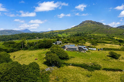
- Price
- £695,000
- Size
- 73.12 acres
Added on 29/01/2026House with Land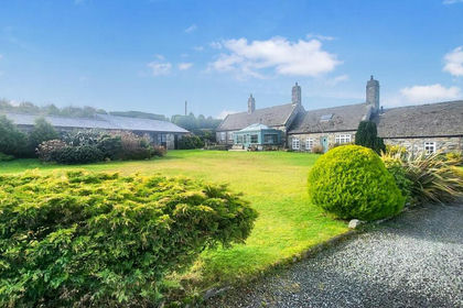
- Price
- £850,000
- Size
- 15 acres
Plas Penbryn Pwll Du, Llandecwyn, Talsarnau, Gwynedd LL47 Wales
Added on 05/04/2026Farmhouse