The Hendre, Monmouth, Monmouthshire, NP25
- Land size
- 100 acres
- Bedrooms
- 5
- Bathrooms
- 2
Key Features
- A 16th Century Traditional Grade II* Listed Farmhouse
- Requires Extensive Renovation and Modernisation
- Range of Traditional and Modern Agricultural Buildings
- Outbuildings with Considerable Scope for Conversion (subject to obtaining the necessary planning consents)
- Approximately 100 acres of Productive Pastureland
- Rural Position yet Conveniently Located
Description
Nestled in the Monmouthshire countryside, The Maerdy Farm presents a unique opportunity to purchase a ringfenced livestock holding, with a substantial 5-bedroom Grade II* Listed farmhouse, an extensive range of both traditional and modern livestock buildings and approx. 100 acres (40.46ha) of productive pastureland.
Land holding up for negotiation.
Description
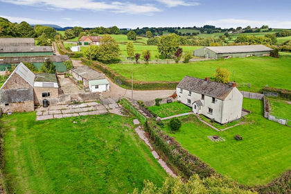
The Maerdy Farm comprises a substantial detached Grade II* brick, five-bedroom fine Renaissance farmhouse, which was once part of the Hendre Estate owned by the Rolls family, rich in character and period charm, accompanied by a collection of domestic outbuildings, comprising a range of both traditional and modern agricultural, practical yard space, and approximately 100 acres of productive agricultural land. The property presents a rare opportunity to restore a rural estate, with significant potential for residential, agricultural or recreational use.
---
The Maerdy Farm enjoys an excellent setting in the scenic Monmouthshire countryside, surrounded by its own land, boasting historical character throughout the holding. A natural stream meanders through the property, creating an idyllic rural setting. Conveniently, the farm lies just a stone’s throw from the B4233, offering ease of access to both market towns of Monmouth and Abergavenny.
Situation
Despite its rural position, the property is conveniently positioned for excellent connectivity. Located on the Onen to Newcastle Road, just off the B4233 Monmouth to Abergavenny Road to the South and the B4347 Monmouth to Skenfrith Road providing links to Ross on Wye and Hereford. The immediate location comprises farmland, sporadic detached rural properties and livestock holdings. Local amenities comprise of Llangattock School (Monmouth Montessori School and Nursery), Llanviangle-Ystern-Llewern Church, The Rolls of Monmouth Golf Club and the Halfway Country Pub. Monmouth is located less than 5 miles distant providing access to a range of further facilities including Haberdashers co-ed Private school for girls and boys, Monmouth Comprehensive school, leisure centre, and a traditional yet useful high street with supermarkets such as Waitrose, M&S and Cooperative store.
Accommodation
The accommodation available at The Maerdy Farm briefly comprises the following:
Lower Ground Floor
Cellar
Ground Floor
Entrance Room- A handy boot room, with glazed basin and original bread oven, Conservatory- East facing, Kitchen – With original flag stone floor and woodburning stove, Inner Passageway- Access to staircase to first floor, Old Dairy – with slating slab and chamfered beams, Buttery - Separate WC, Study- With wooden floor, Sitting Room – with wooden floor, chamfered beams, fireplace and walk in cupboards
First Floor
Landing and five bedrooms - All bedrooms have period features with chamfered beams, with some featuring original fireplaces
Attic
Attic – With exposed beams, large landing with four interconnecting rooms.
Outside
The farmhouse benefits from a large forecourt, offering parking for a number of vehicles. The property features a pleasant cottage style walled garden. There are a number of domestic outbuildings in close proximity including storage, coal/wood store, domestic barn and former cider house. Positioned within the main yard are a number of attractive brick-built outbuildings, offering excellent potential for conversion, subject to the necessary planning consents to create additional living space, recreational amenities, or professional facilities, adding to the adaptability of holding.
Farm Buildings
The property comprises a range of useful modern and traditional agricultural buildings including:
Traditional Farmstead
Brick Barn – Two Storey Grade 11 brick construction with timber and adjoining cider house Former Cider House- Grade 11 listed brick constructed barn Detached stable block and shelter- 8 bay single storey, Grade 11 listed
Modern Agricultural Buildings
An extensive range, comprising 5 modern steel portal framed agricultural buildings, including galvanised cow shed with cubicles.
The Land
The land extends to approximately 100 acres being 75 m above sea level of predominantly Grade 2 agricultural land, well-suited for both mowing and grazing. The soils are principally loam with areas of clay, offering a productive and versatile foundation for a range of agricultural enterprises.
Further Land
Lot 2 - Further land available by separate negotiation - Approximately 34.29 acres at Llandishty - Guide Price £240,000
The Boundaries
The Purchaser shall be deemed to have full knowledge of the boundaries and neither the Vendor nor the Agent should be required to produce evidence as to the ownership of the boundaries.
Tenure
Freehold with vacant possession upon completion.
Services
The property benefits from mains electricity and Borehole fed water. There is a private drainage system by way of a septic tank and heating is provided by a private oil supply. The land benefits from a natural water supply from Llymon Brook None of these services have been tested.
Basic Payment Scheme
The land is registered with the Welsh Government under the Basic Payment Scheme (BPS). Entitlements are available by separate negotiation. The land is not entered into any Agri-Environmental Schemes.
EPC
Due to the listing status, an EPC is not required.
Lotting and reserve
It is anticipated that the property will be offered as shown but the Vendor reserves the right to withdraw, alter or amend the extent of the property being offered.
---
The property is sold subject to any rights, benefits or incidents of tenure which affect it.
Local Authority
Monmouthshire County Council
Viewing
Strictly by appointment with the sole Agents David James. Please contact the Monmouth Office and ask to speak with John Jenkins or Fiona Wall.
Map Location
Property details
- Tenure
- Freehold
- Council Tax Band
- TBC
- Date Posted
- 2026-06-18
Market Value Analysis
Compared with 43 Farms & Smallholdings listings in Wales (100+ acres).
Utilities & Restrictions
Utilities
- Electricity
- Ask Agent
- Water
- Ask Agent
- Heating
- Ask Agent
- Broadband
- Ask Agent
- Sewerage
- Ask Agent
Rights & Restrictions
- Public Rights of Way
- Ask Agent
- Private Rights of Way
- Ask Agent
- Listed Property
- Ask Agent
- Restrictions
- Ask Agent
Listed status, conservation areas and planning constraints for this location are in the full report.
Property Features
- Accessibility
- Ask Agent
- Parking
- Parking Available
- Garden
- Garden
Beyond the particulars: planning activity, flood history, heritage and ground risks, checked for this exact spot.
Connectivity
Broadband
Fastest speed available at this postcode
5 Mbps
Under 10 Mbps here
Suitable for
- Basic browsing & email
Mobile signal
Predicted 4G and 5G signal; indoor signal depends on building materials.
Ofcom Connected Nations postcode-level predictions. Speeds and signal are modelled, not measured, and vary between addresses and providers.
Signal is the easy part. Planning activity, flood history and protected designations here are in the full report.
Nearest Schools
Primary
- Cross Ash County Primary School3.6 miles
- Pupils
- 166
- Type
- Infants & Juniors
- Language
- English medium school / provision
- Overmonnow Primary School4.3 miles
- Pupils
- 337
- Type
- Nursery, Infants & Juniors
- Language
- English medium school / provision
- Ysgol Gymraeg Trefynwy4.3 miles
- Pupils
- 21
- Type
- Nursery, Infants & Juniors
- Language
- Welsh medium school / provision (including transitional)
- Osbaston Church in Wales School4.4 miles
- Pupils
- 197
- Type
- Infants & Juniors
- Language
- English medium school / provision
- Raglan Primary4.8 miles
- Pupils
- 165
- Type
- Infants & Juniors
- Language
- English medium school / provision
Secondary
- Monmouth Comprehensive School4.9 miles
- Pupils
- 1,696
- Type
- Secondary (ages 11-19)
- Language
- English medium school / provision
- King Henry VIII 3198.6 miles
- Pupils
- 1,310
- Type
- Middle (ages 3-19)
- Language
- English medium school / provision
- Ysgol Gymraeg Gwynllyw12 miles
- Pupils
- 808
- Type
- Middle (ages 3-19)
- Language
- Welsh medium school / provision (including transitional)
- Abersychan Comprehensive13 miles
- Pupils
- 739
- Type
- Secondary (ages 11-16)
- Language
- English medium school / provision
- St. Albans R.C. High School13 miles
- Pupils
- 824
- Type
- Secondary (ages 11-16)
- Language
- English medium school / provision
Distances are straight-line from the advertised location. Source: the national school registers (DfE, Welsh Government, Scottish Government) and Ofsted.
Schools are just the start: sold prices nearby, planning activity and any flood history are in the full report.
Amenities
Supermarket
GP surgery
Pharmacy
Walking trail
Straight-line distances from the advertised location. Sources: NHS records, Geolytix supermarket locations, OS Open Greenspace and the national trails registers.
The area stacks up? Now check the location itself: planning nearby, protected designations and past flooding.
Getting Around
Nearest station
Nearest bus stop
Typical drive times
Straight-line distances from the advertised location; drive times are typical free-flow times over OpenStreetMap road data, so allow more at peak. Public transport locations from DfT NaPTAN.
Easy to reach matters. So do planning activity, flood history and ground risks: all in the full report.
Flood Risk
Natural Resources Wales open data, checked around the advertised map pin for the listed acreage. Long-term risk counts flood defences; the planning map's flood zones do not. Provided by LandSale, not the listing agent, and not part of the agent's particulars. Risk varies across a holding, so verify before committing.
Rivers and the sea
Not at the pin: mapped about 120 metres away.
Planning map: Flood Zone 3, about 120 metres away.
Surface water
Not at the pin: mapped about 40 metres away.
These bandings are the summary. Where this location sits on the flood maps, plus planning activity, heritage and ground risks, is in the full report.
Important notice: Information, maps and tags on this page are drawn from the advertising agent's marketing materials or generated automatically. LandSale has not verified them. Relying on these details is at your own risk, always carry out independent checks before committing to a purchase.
LandSale full disclaimer
Marketing information only - not formal particulars. The details on this website are provided for general guidance and do not constitute an offer or contract. Neither LandSale nor the advertising estate/land agent accepts responsibility for any inaccuracy.
1. Source of information
- Listing content: Core description, asking price, tenure, measurements, photographs and planning history originate from the marketing materials of the advertising estate or land agent. LandSale does not author this content and cannot guarantee its accuracy.
- Automated tags & categorisation: Property type, land-use class, acreage bands and similar labels may be applied by machine-learning models. They are intended as a helpful guide only and may not reflect the property's legal status or permitted use.
- Third-party & enriched data layers: Maps, boundary outlines, planning designations, soil reports, broadband coverage and other environmental or location-based insights are licensed from external suppliers. Such data are supplied “as is", may be incomplete or out of date and are subject to change without notice.
2. Verification required
Prospective purchasers must verify critical matters, including but not limited to planning permission, title boundaries, public rights of way, environmental constraints, acreage, services, access and VAT status, through their own inspections, specialist surveys, legal advisers and the selling agent before relying on the information or entering into any contract.
3. No warranty or liability
LandSale gives no warranty, express or implied, as to the accuracy, completeness or fitness for any particular purpose of the information displayed. LandSale shall not be liable for any loss, damage, cost or expense arising directly or indirectly from any use of or reliance on such information, save where liability may not be excluded by law.
4. Updates & feedback
If you believe any detail on this listing is inaccurate, please let us know. We will investigate and, where appropriate, update the listing or notify the agent.
© LandSale | Version 1.3 - August 2026
Similar properties for sale
- Price
- Guide Price£1,600,000
- Size
- 100 acres
Added on 01/08/2026Farm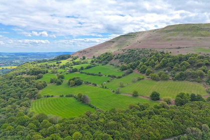
- Price
- £1,500,000
- Size
- 228 acres
Llanfoist, Abergavenny., Llanfoist Fawr, Monmouthshire NP7 Wales
Added on 11/05/2026Farmland
- Price
- Guide Price£1,350,000
- Size
- 122.21 acres
Greenmeadow Farm, Mamhilad, Pontypool, Monmouthshire, NP4, Goetre Fawr, Monmouthshire NP4 Wales
Added on 26/06/2026Farm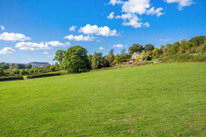
- Price
- Guide Price£1,150,000
- Size
- 50 acres
Longtown, Hereford, Longtown, Herefordshire, County of HR2 England
Added on 15/10/2026House with Land
- Price
- Guide Price£1,100,000
- Size
- 97.25 acres
Llwyn-y-Celyn Farm Lot 2, Shirenewton, Chepstow, NP16, Shirenewton, Monmouthshire NP16 Wales
Added on 29/01/2026Dairy Farm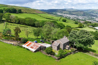
- Price
- Offers in Excess of£1,400,000
- Size
- 325 acres
Carncelyn & Penygraig Farm, Tonypandy, CF40, Pen-y-graig, Rhondda Cynon Taf CF40 Wales
Added on 28/01/2026Farm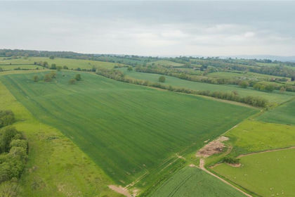
- Price
- £1,675,000
- Size
- 134.31 acres
Lot 4, Parsonage Farm, Kyre, Tenbury Wells, Worcestershire, Kyre, Worcestershire WR15 England
Added on 16/05/2026Farm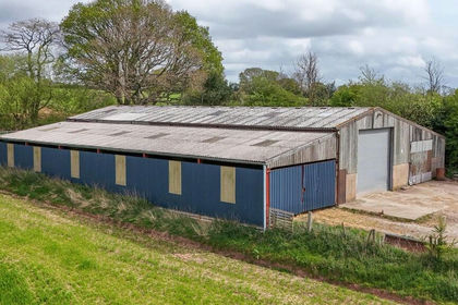
- Price
- Guide Price£1,400,000
- Size
- 119.37 acres
Gorse Hill Farm, Clifton-upon-Teme WR6, Tedstone Delamere, Herefordshire, County of WR6 England
Added on 29/01/2026Farm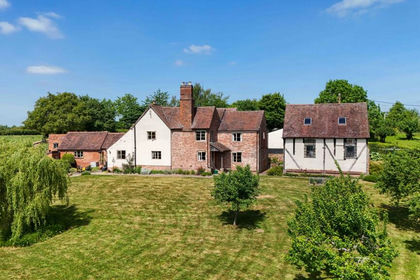
- Price
- Guide Price£1,385,000
- Size
- 95 acres
Tan House Lane, Rushwick, WR2, Rushwick, Worcestershire WR2 England
Added on 29/01/2026Farm
- Price
- Guide Price£1,385,000
- Size
- 95 acres
Tan House Lane, Rushwick WR2, Rushwick, Worcestershire WR2 England
Added on 29/01/2026Farm