The Greaves, Minworth, B76
- Bedrooms
- 2
- Bathrooms
- 1
Key Features
- Grade II listed character barn conversion
- Exclusive landscaped courtyard development
- Two bedrooms, versatile ground floor layout
- Vaulted ceilings with exposed timber beams
- Open-plan first floor living space
- Stylish modern kitchen with dining area
- Beautifully maintained communal gardens
- Allocated resident parking space
- Semi-rural setting with countryside nearby
- Convenient access to transport links
Description
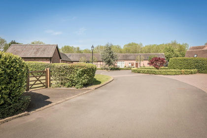
Set within an exclusive courtyard of historic barn conversions, 14 The Greaves is a beautifully presented Grade II listed home, rich in character and enjoying a wonderfully tranquil semi-rural setting on the edge of open countryside. Forming part of a sympathetically converted former farmstead, the property effortlessly combines period charm with modern convenience. Externally, the development is centred around a striking communal courtyard with mature landscaping, creating an immediate sense of privacy and arrival, while allocated parking adds everyday practicality. The accommodation is arranged over two floors and showcases an abundance of original features, including exposed timbers and vaulted ceilings, thoughtfully complemented by contemporary finishes. The layout offers versatility, with well-proportioned bedrooms to the ground floor and an impressive open-plan living space above, designed to make the most of light, space and character. Enjoying a peaceful position within the development, yet remaining well placed for local amenities, transport links and nearby countryside walks.
This is a rare opportunity to acquire a distinctive home within a sought-after and characterful setting.
Location - Situated within the exclusive and historic setting of The Greaves in Minworth, this unique property forms part of a characterful conversion of a former Georgian farmhouse, surrounded by attractive semi-rural surroundings. The area offers a blend of countryside living with excellent connectivity, lying on the edge of Sutton Coldfield and within easy reach of local amenities, schooling and leisure facilities.
The nearby villages of Curdworth and Wishaw provide a traditional village feel, while Sutton Coldfield offers a comprehensive range of shops, restaurants and services. The property is also well positioned for access to major road networks, making it ideal for commuters.
Travel Distances
Sutton Coldfield – approximately 5 miles
Coleshill – approximately 4 miles
Birmingham City Centre – approximately 9 miles
Lichfield – approximately 10 miles
M6 (Junction 5) – approximately 3 miles
M42 (Junction 9) – approximately 4 miles
Birmingham Airport – approximately 8 miles
Accommodation Details - Entering the property, you are welcomed into a well-presented entrance hall which immediately sets the tone for the home, with its clean, neutral décor complemented by exposed timbers and traditional latch doors that reflect the building’s heritage. There is useful built-in storage and a ground floor cloakroom, while the staircase rises to the first floor, partially open to the living space above, allowing light to filter through. From the hall, doors lead to two ground floor rooms. The principal bedroom is a generous double, tastefully decorated and offering a calm and comfortable retreat. A second bedroom provides versatility and is currently arranged as a study or occasional bedroom, ideal for those working from home or requiring additional flexible space. The bathroom is also located on the ground floor and is fitted with a three-piece suite including a bath with shower over, pedestal wash hand basin and WC, all finished in a neutral style.
Rising to the first floor, the property opens into a striking open-plan living space, undoubtedly the heart of the home. Here, the full character of the barn conversion is on display, with vaulted ceilings, exposed beams and rooflights creating a light-filled and atmospheric environment. The living area offers ample space for seating, while the adjoining dining area provides a natural place for entertaining. The kitchen is thoughtfully arranged along one side, fitted with a range of units and work surfaces, and positioned to enjoy the elevated outlook across the development.
The open-plan layout ensures the space feels sociable and connected, ideal for modern living. Overall, the accommodation flows beautifully, combining practical ground floor bedrooms with an impressive and characterful first floor living space.
Outside - Externally, the property is set within an attractive and well-maintained courtyard development, forming part of this charming Grade II listed barn conversion. The communal grounds are a particular feature, with established planting, mature trees and neatly kept pathways creating a peaceful and picturesque setting for residents.
There is allocated parking conveniently located close to the property, along with additional visitor spaces available within the courtyard. The setting offers a real sense of community while still maintaining privacy.
The immediate surroundings provide a pleasant blend of landscaped areas and open aspects, with glimpses across neighbouring countryside adding to the appeal. The position also benefits from being set back from the road, enhancing the quiet and tucked-away feel of the development.
The History - The Greaves forms part of a distinctive Grade II listed development believed to originate from former agricultural buildings associated with the surrounding farmland, sympathetically converted to residential use in the late 20th century. Retaining much of their original character, the buildings showcase traditional timber framing and barn-style architecture, reflecting the area’s rural heritage. Minworth itself has historic roots as a small Warwickshire village, historically linked to farming and later light industry, evolving over time into a well-connected semi-rural location. Today, it offers an appealing balance of countryside surroundings and modern convenience, with the nearby Sutton Coldfield providing a broader range of amenities while the immediate area still retains a sense of its historic, pastoral origins.
Viewing Arrangements - Strictly by prior appointment via the agents Howkins & Harrison Tel:01827-718021 Option 1
Local Authority - Birmingham City Council - Tel:0121-303-1113
Council Tax - Band - D
Agents Note - Additional information about the property, including details of utility providers, is available upon request. Please contact the agent for further details.
Tenure & Possession - The property is freehold with vacant possession being given on completion
Fixtures And Fittings - Only those items in the nature of fixtures and fittings mentioned in these particulars are included in the sale. Other items are specifically excluded. None of the appliances have been tested by the agents and they are not certified or warranted in any way.
Services - None of the services have been tested. We are advised that mains water, drainage, gas and electricity are connected to the property. The central heating is gas fired and broadband is available.
Floorplan - Howkins & Harrison prepare these plans for reference only. They are not to scale.
Additional Services - Do you have a house to sell? Howkins and Harrison offer a professional service to home owners throughout the Midlands region. Call us today for a Free Valuation and details of our services with no obligation whatsoever.
Important Information - Every care has been taken with the preparation of these Sales Particulars, but complete accuracy cannot be guaranteed. In all cases, buyers should verify matters for themselves. Where property alterations have been undertaken buyers should check that relevant permissions have been obtained. If there is any point, which is of particular importance let us know and we will verify it for you. These Particulars do not constitute a contract or part of a contract. All measurements are approximate. The Fixtures, Fittings, Services & Appliances have not been tested and therefore no guarantee can be given that they are in working order. Photographs are provided for general information and it cannot be inferred that any item shown is included in the sale. Plans are provided for general guidance and are not to scale.
Map Location
Property details
- Tenure
- Freehold
- Council Tax Band
- Ask Agent
- Date Posted
- 2026-06-18
Energy Performance Certificate
Energy Efficiency Rating
Based on UK Energy Performance Certificate standards (EU Directive 2002/91/EC)
Running costs are one side. Planning activity, flood history and ground risks for this location are in the full report.
Utilities & Restrictions
Utilities
- Electricity
- Ask Agent
- Water
- Ask Agent
- Heating
- Ask Agent
- Broadband
- Ask Agent
- Sewerage
- Ask Agent
Rights & Restrictions
- Public Rights of Way
- Ask Agent
- Private Rights of Way
- Ask Agent
- Listed Property
- Ask Agent
- Restrictions
- Ask Agent
Listed status, conservation areas and planning constraints for this location are in the full report.
Property Features
- Accessibility
- Ask Agent
- Parking
- Parking Available
- Garden
- Ask Agent
Beyond the particulars: planning activity, flood history, heritage and ground risks, checked for this exact spot.
Connectivity
Broadband
Fastest speed available at this postcode
16 Mbps
Standard (10-30 Mbps)
Suitable for
- Web & social
- Music streaming
- Standard video calls
Mobile signal
Outdoor predictions; indoor signal depends on building materials.
Ofcom Connected Nations postcode-level predictions. Speeds and signal are modelled, not measured, and vary between addresses and providers.
Signal is the easy part. Planning activity, flood history and protected designations here are in the full report.
Nearest Schools
Primary
- Minworth Junior and Infant School906 metresOfsted: Good
- Ages
- 4 to 11
- Pupils
- 204
- Type
- Community school
- Curdworth Primary School0.9 milesNo Ofsted rating
- Ages
- 4 to 11
- Pupils
- 106
- Type
- Academy converter
- Water Orton Primary School1.3 milesOfsted report card · May 2026
- Ages
- 4 to 11
- Pupils
- 299
- Type
- Community school
- Pegasus Primary School1.3 milesOfsted report card · Dec 2025
- Ages
- 5 to 11
- Pupils
- 160
- Type
- Academy converter
- St Gerard's Catholic Primary School1.4 milesNo Ofsted rating
- Ages
- 3 to 11
- Pupils
- 235
- Type
- Voluntary aided school
- Faith
- Roman Catholic
Secondary
- Lift Greenwood1.3 milesOfsted report card · Jan 2026
- Ages
- 11 to 18
- Pupils
- 935
- Type
- Academy sponsor led
- Park Hall Academy1.4 milesNo Ofsted rating
- Ages
- 11 to 18
- Pupils
- 1,269
- Type
- Academy sponsor led
- Smith's Wood Academy2.3 milesOfsted report card · Jan 2026
- Ages
- 11 to 16
- Pupils
- 697
- Type
- Academy sponsor led
- Bishop Walsh Catholic School2.6 milesNo Ofsted rating
- Ages
- 11 to 18
- Pupils
- 1,076
- Type
- Academy converter
- Faith
- Roman Catholic
- The Royal Sutton School2.6 milesOfsted: Good
- Ages
- 11 to 16
- Pupils
- 966
- Type
- Academy sponsor led
Distances are straight-line from the advertised location. Source: the national school registers (DfE, Welsh Government, Scottish Government) and Ofsted.
Schools are just the start: sold prices nearby, planning activity and any flood history are in the full report.
Amenities
Supermarket
GP surgery
Pharmacy
Hospital
Green space
Straight-line distances from the advertised location. Sources: NHS records, Geolytix supermarket locations, OS Open Greenspace and the national trails registers.
The area stacks up? Now check the location itself: planning nearby, protected designations and past flooding.
Getting Around
Nearest station
Nearest bus stop
Typical drive times
Straight-line distances from the advertised location; drive times are typical free-flow times over OpenStreetMap road data, so allow more at peak. Public transport locations from DfT NaPTAN.
Easy to reach matters. So do planning activity, flood history and ground risks: all in the full report.
Flood Risk
From Environment Agency flood map open data, checked around the advertised map pin and allowing for the listed acreage where known. This summary comes from LandSale, the advertising platform, not from the listing agent, and is not part of the agent's particulars. Risk can vary across a single holding, so verify anything critical through your own searches before committing.
Rivers and the sea
Surface water
The detail behind these bandings
The full report pinpoints where this location sits on the flood maps, and runs the deeper checks that usually only surface after an offer.
- Exact flood zones & annual chances (included in the full report)
- Any recorded past flooding (included in the full report)
- Planning activity nearby (included in the full report)
- Heritage & conservation (included in the full report)
- Protected nature designations (included in the full report)
- Ground risks (included in the full report)
- Sold prices nearby (included in the full report)
£14.99 · one-off purchase
By LandSale, the platform. Not provided by the listing agent. Ready in about a minute.
Important notice: Information, maps and tags on this page are drawn from the advertising agent's marketing materials or generated automatically. LandSale has not verified them. Relying on these details is at your own risk, always carry out independent checks before committing to a purchase.
LandSale full disclaimer
Marketing information only - not formal particulars. The details on this website are provided for general guidance and do not constitute an offer or contract. Neither LandSale nor the advertising estate/land agent accepts responsibility for any inaccuracy.
1. Source of information
- Listing content: Core description, asking price, tenure, measurements, photographs and planning history originate from the marketing materials of the advertising estate or land agent. LandSale does not author this content and cannot guarantee its accuracy.
- Automated tags & categorisation: Property type, land-use class, acreage bands and similar labels may be applied by machine-learning models. They are intended as a helpful guide only and may not reflect the property's legal status or permitted use.
- Third-party & enriched data layers: Maps, boundary outlines, planning designations, soil reports, broadband coverage and other environmental or location-based insights are licensed from external suppliers. Such data are supplied “as is", may be incomplete or out of date and are subject to change without notice.
2. Verification required
Prospective purchasers must verify critical matters, including but not limited to planning permission, title boundaries, public rights of way, environmental constraints, acreage, services, access and VAT status, through their own inspections, specialist surveys, legal advisers and the selling agent before relying on the information or entering into any contract.
3. No warranty or liability
LandSale gives no warranty, express or implied, as to the accuracy, completeness or fitness for any particular purpose of the information displayed. LandSale shall not be liable for any loss, damage, cost or expense arising directly or indirectly from any use of or reliance on such information, save where liability may not be excluded by law.
4. Updates & feedback
If you believe any detail on this listing is inaccurate, please let us know. We will investigate and, where appropriate, update the listing or notify the agent.
© LandSale | Version 1.3 - August 2026
Listing agent
Howkins & Harrison LLP, Atherstone
15 Market Street Atherstone CV9 1ET
Similar properties for sale
- Price
- Offers Over£350,000
Country Park View, Sutton Coldfield, B76, Sutton Coldfield, Birmingham B76 England
Added on 14/05/2026Barn Conversion
- Price
- Guide Price£325,000
Pinfold Lane, Aldridge, Walsall, Aldridge-Brownhills, Walsall WS9 England
Added on 27/05/2026Barn Conversion
- Price
- Offers in Excess of£300,000
Jean Street, Baddesley Ensor, CV9, Baddesley Ensor, Warwickshire CV9 England
Added on 29/01/2026Building Plot
- Price
- £260,000
- Size
- 0.25 acres
Added on 11/07/2026Self Build Plot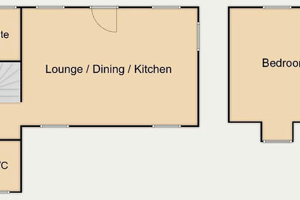
- Price
- Guide Price£340,000
Calderfields Farm, Aldridge Road, Walsall, Walsall and Bloxwich, Walsall WS4 England
Added on 04/06/2026Barn Conversion
- Price
- Guide Price£240,000
- Size
- 0.47 acres
Clive Road, Quinton, BIRMINGHAM, Birmingham Edgbaston, Birmingham B32 England
Added on 21/08/2026Building Plot
- Price
- Guide Price£250,000
Jacker's Road, ALDERMANS GREEN, Coventry, CV2, Coventry East, Coventry CV2 England
Added on 22/06/2026Building Plot
- Price
- £350,000
Lupin Farm Stable, Alrewas Road, Burton-On-Trent, DE13, King's Bromley, Staffordshire DE13 England
Added on 29/01/2026Barn Conversion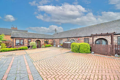 Added on 22/05/2026Barn Conversion
- Price
- Offers in Region of£299,950
265b Penn Road, Penn, Wolverhampton, WV4, Wolverhampton West, Wolverhampton WV4 England
Added on 10/08/2026Building Plot