Dalton House, Near Ponteland, Northumberland
- Land size
- 2.85 acres
- Bedrooms
- 6
- Bathrooms
- 4
Key Features
- Impressive Stone-built Property
- Planning Permission for Ancillary Dwelling
- Generous & Flexible Accommodation
- Around 2.85 Acres in All
- Excellent Access to Airport
- Grade II Listed
- Beautiful Gardens & Paddock
Description
Accommodation in Brief
Porch | Entrance Hall | Drawing Room | Sitting/Dining Room | Kitchen/Breakfast Room | Utility | Family Room | Snug | Conservatory | Cloakroom/WC | Rear Hall | Second Kitchen | Principal Bedroom with En-suite Bathroom | Five Further Double Bedrooms | Three Bathrooms | Linen Room
Paddock | Gardens | Garage | Parking | Stable | Studio/Office | Tack Room | Two Wood Sheds | Wood Store | Gardeners WC
The Property
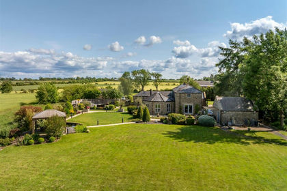
Dalton House, originally built in the early 19th century, stands as an impressive stone-built residence that was significantly altered and extended in the early 1900s. This splendid property is set within approximately 2.8 acres of beautifully landscaped gardens and grounds. A magnificent tree-lined avenue and driveway lead to an open courtyard and a spacious parking area capable of accommodating numerous vehicles.
The house benefits from a small grazing paddock at the front, while the rear and side of the property feature meticulously manicured lawns, vibrant flower beds, and shrub borders, offering ample relaxation space. Additionally, the property boasts excellent detached outbuildings, including a workshop/studio, a large garage, a stable, and a separate range of structures under a pantiled roof, such as a general store and a gardener’s WC.
Dalton House’s unique stone architecture, generous family accommodation, and stunning garden views make it an exceptionally appealing and significant property.
The property retains a truly welcoming and traditional atmosphere, now complemented by elegant, updated decor. This includes fresh, neutral colors in the expansive drawing room, delightful sitting/dining room, and airy, high-ceilinged rooms throughout. Each space harmoniously combines modern aesthetics with the property’s historical elements, such as decorative cornicing and charming ceiling roses. The kitchen/breakfast room continues to feature classic country style, updated with a lighter palette around the striking stone inglenook that houses a stunning AGA. The kitchen is served by an adjoining utility and connects to a rear hall in the west wing of the property, which has a separate private entrance and continues as a successful Bed & Breakfast.
Stairs rise from the main hall and also from the rear hall to the first floor and the bedroom accommodation. The same, tastefully neutral palette is preserved in the bedrooms and bathrooms. The principal bedroom is hugely generous, with glorious views over the front gardens and an en-suite bathroom that is Jack & Jill to the upper hall. There are five further double bedrooms, all elegantly appointed and with views over various aspects of the gardens. The bedrooms are served by three family bathrooms, and there is also a linen room that could be configured as an additional bedroom if required.
Externally
The property is approached via a tree-lined tarmacadam driveway that passes through the lovely gardens and grounds to an open courtyard with parking for an impressive number of vehicles. The beautiful gardens have been carefully laid out and perfectly maintained to create attractive and peaceful surroundings that can be enjoyed all year round. There are sweeping areas of lawn along with mature fruit trees and a variety of well-established beds and borders featuring colourful plantings and shrubs. A paved terrace runs across the rear of the house with direct access from the conservatory. This is a perfect spot for outdoor entertaining and dining. The peace and privacy is further enhanced by the mature trees and shrubs that wrap around the property.
The property benefits from a range of outbuildings. The detached garage and stable has planning permission to convert into two-bedroom cottage, and there is also a tack room, two woodsheds, a wood store and a useful gardeners WC. The grazing paddock to the front of the property adds to the feeling of space and tranquillity.
Local Information
The nearby historic village of Ponteland offers a good range of day-to-day facilities including newsagents, grocery stores, public houses, critically-acclaimed restaurants and bistros, boutiques and other local businesses together with a wide range of sports clubs and leisure centre. There are doctors surgeries in Ponteland and Stamfordham. Ponteland also has pharmacies as well as dental practices.
The area benefits from excellent school provision. Ponteland offers a choice of excellent first, middle and senior schools; in addition there are a number of private schools in Newcastle. There is a full range of professional services and hospitals as well as cultural, recreational and shopping facilities in Newcastle city centre.
For the commuter the property is conveniently located for access to Newcastle and beyond, with the A696 running close by, and the A1 and A69 easily accessible. Newcastle Central station offers main line services to major UK cities north and south and Newcastle International Airport is also within easy reach.
Approximate Mileages
Newcastle International Airport 5.7 miles | Newcastle City Centre 11.2 miles | Corbridge 10.5 miles
Services
Mains water and electricity. Private drainage. Oil-fired central heating.
Wayleaves, Easements & Rights of Way
The property is being sold subject to all existing wayleaves, easements and rights of way, whether or not specified within the sales particulars.
Agents Note to Purchasers
We strive to ensure all property details are accurate, however, they are not to be relied upon as statements of representation or fact and do not constitute or form part of an offer or any contract. All measurements and floor plans have been prepared as a guide only. All services, systems and appliances listed in the details have not been tested by us and no guarantee is given to their operating ability or efficiency. Please be advised that some information may be awaiting vendor approval.
Submitting an Offer
Please note that all offers will require financial verification including mortgage agreement in principle, proof of deposit funds, proof of available cash and full chain details including selling agents and solicitors down the chain. To comply with Money Laundering Regulations, we require proof of identification from all buyers before acceptance letters are sent and solicitors can be instructed.
Directions
From Ponteland village centre take the A696 heading north towards Belsay. After leaving Ponteland village take the left turn onto Limestone Lane signposted Dissington, Dalton, Stamfordham. Continue on Limestone Lane for 2.2 miles then at the T-junction turn left. Take the next right turn on to Paddock Lane and continue for 0.7 miles into the hamlet of Dalton. Towards the end of the hamlet you will see a red post box on the right-hand side. Stay on the main road and the entrance to the property is the last entrance on the right just before the bend to leave the village towards Stamfordham.
Map Location
Property details
- Tenure
- Freehold
- Council Tax Band
- H
- Date Posted
- 2026-06-17
Market Value Analysis
Compared with 204 Homes with Land listings in North East England (1+ acres).
Utilities & Restrictions
Utilities
- Electricity
- Mains
- Water
- Mains
- Heating
- Oil Heating
- Broadband
- Ask Agent
- Sewerage
- Septic Tank / Private
Rights & Restrictions
- Public Rights of Way
- Ask Agent
- Private Rights of Way
- Ask Agent
- Listed Property
- Ask Agent
- Restrictions
- Ask Agent
Listed status, conservation areas and planning constraints for this location are in the full report.
Property Features
- Accessibility
- Ask Agent
- Parking
- Parking Available
- Garden
- Garden
Beyond the particulars: planning activity, flood history, heritage and ground risks, checked for this exact spot.
Connectivity
Broadband
Fastest speed available at this postcode
1.8 Gbps
Gigabit full fibre · available to 91% of premises
Suitable for
- 4K streaming on every screen
- Full-time home working
- Online gaming & big downloads
Mobile signal
Outdoor predictions; indoor signal depends on building materials.
Ofcom Connected Nations postcode-level predictions. Speeds and signal are modelled, not measured, and vary between addresses and providers.
Signal is the easy part. Planning activity, flood history and protected designations here are in the full report.
Nearest Schools
Primary
- Stamfordham Primary School1.8 milesOfsted: Good
- Ages
- 2 to 11
- Pupils
- 84
- Type
- Community school
- Darras Hall Primary School2.7 milesOfsted: Outstanding
- Ages
- 3 to 11
- Pupils
- 459
- Type
- Academy converter
- Ponteland Primary School3.4 milesNo Ofsted rating
- Ages
- 3 to 11
- Pupils
- 479
- Type
- Academy converter
- Richard Coates Church of England Primary School3.4 milesNo Ofsted rating
- Ages
- 3 to 11
- Pupils
- 328
- Type
- Academy converter
- Faith
- Church of England
- Heddon-on-the-Wall, St Andrew's Church of England Primary School3.5 milesNo Ofsted rating
- Ages
- 3 to 11
- Pupils
- 220
- Type
- Academy converter
- Faith
- Church of England
Secondary
- Ponteland High School3.5 milesOfsted: Good
- Ages
- 11 to 18
- Pupils
- 1,536
- Type
- Academy converter
- Walbottle Academy4.8 milesOfsted: Good
- Ages
- 11 to 18
- Pupils
- 1,722
- Type
- Academy sponsor led
- Thorp Academy5.3 milesNo Ofsted rating
- Ages
- 11 to 18
- Pupils
- 1,442
- Type
- Academy sponsor led
- Ovingham Middle School5.6 milesNo Ofsted rating
- Ages
- 9 to 13
- Pupils
- 344
- Type
- Academy converter
- Callerton Academy5.9 milesOfsted: Good
- Ages
- 11 to 16
- Pupils
- 684
- Type
- Free schools
Distances are straight-line from the advertised location. Source: the national school registers (DfE, Welsh Government, Scottish Government) and Ofsted.
Schools are just the start: sold prices nearby, planning activity and any flood history are in the full report.
Amenities
Supermarket
GP surgery
Pharmacy
Hospital
Straight-line distances from the advertised location. Sources: NHS records, Geolytix supermarket locations, OS Open Greenspace and the national trails registers.
The area stacks up? Now check the location itself: planning nearby, protected designations and past flooding.
Getting Around
Nearest station
Nearest bus stop
Typical drive times
Straight-line distances from the advertised location; drive times are typical free-flow times over OpenStreetMap road data, so allow more at peak. Public transport locations from DfT NaPTAN.
Easy to reach matters. So do planning activity, flood history and ground risks: all in the full report.
Flood Risk
From Environment Agency flood map open data, checked around the advertised map pin and allowing for the listed acreage where known. This summary comes from LandSale, the advertising platform, not from the listing agent, and is not part of the agent's particulars. Risk can vary across a single holding, so verify anything critical through your own searches before committing.
Rivers and the sea
Surface water
These bandings are the summary. Where this location sits on the flood maps, plus planning activity, heritage and ground risks, is in the full report.
Important notice: Information, maps and tags on this page are drawn from the advertising agent's marketing materials or generated automatically. LandSale has not verified them. Relying on these details is at your own risk, always carry out independent checks before committing to a purchase.
LandSale full disclaimer
Marketing information only - not formal particulars. The details on this website are provided for general guidance and do not constitute an offer or contract. Neither LandSale nor the advertising estate/land agent accepts responsibility for any inaccuracy.
1. Source of information
- Listing content: Core description, asking price, tenure, measurements, photographs and planning history originate from the marketing materials of the advertising estate or land agent. LandSale does not author this content and cannot guarantee its accuracy.
- Automated tags & categorisation: Property type, land-use class, acreage bands and similar labels may be applied by machine-learning models. They are intended as a helpful guide only and may not reflect the property's legal status or permitted use.
- Third-party & enriched data layers: Maps, boundary outlines, planning designations, soil reports, broadband coverage and other environmental or location-based insights are licensed from external suppliers. Such data are supplied “as is", may be incomplete or out of date and are subject to change without notice.
2. Verification required
Prospective purchasers must verify critical matters, including but not limited to planning permission, title boundaries, public rights of way, environmental constraints, acreage, services, access and VAT status, through their own inspections, specialist surveys, legal advisers and the selling agent before relying on the information or entering into any contract.
3. No warranty or liability
LandSale gives no warranty, express or implied, as to the accuracy, completeness or fitness for any particular purpose of the information displayed. LandSale shall not be liable for any loss, damage, cost or expense arising directly or indirectly from any use of or reliance on such information, save where liability may not be excluded by law.
4. Updates & feedback
If you believe any detail on this listing is inaccurate, please let us know. We will investigate and, where appropriate, update the listing or notify the agent.
© LandSale | Version 1.3 - August 2026
Listing agent
Ellisons, Edinburgh
Suite 2, Ground Floor, Orchard Brae House, 30 Queensferry Road, Edinburgh, EH4 2HS
Contact Ellisons, Edinburgh
Suite 2, Ground Floor, Orchard Brae House, 30 Queensferry Road, Edinburgh, EH4 2HS
View agent profileSimilar properties for sale
- Price
- Offers Over£1,750,000
- Size
- 3.2 acres
Sylvan View, Eachwick, NE18, Stamfordham, Northumberland NE18 England
Added on 29/01/2026Barn Conversion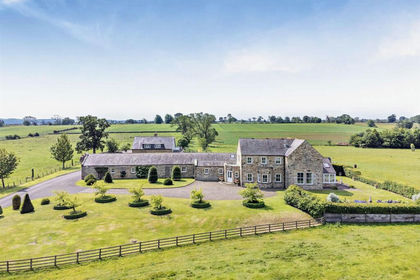
- Price
- Guide Price£1,500,000
- Size
- 17.06 acres
Added on 22/07/2026House with Land
- Price
- Guide Price£1,600,000
- Size
- 15.5 acres
Wallhouses South Farm, Corbridge, Northumberland, Matfen, Northumberland NE45 England
Added on 16/07/2026Farmhouse
- Price
- Offers Over£1,495,000
- Size
- 5.2 acres
West House, Whalton, Morpeth, Northumberland, Whalton, Northumberland NE61 England
Added on 29/08/2026House with Land
- Price
- Guide Price£1,995,000
- Size
- 2.64 acres
Bowes Hill, Newton Hall, Newton, Stocksfield, Northumberland, Bywell, Northumberland NE43 England
Added on 24/07/2026Barn Conversion
- Price
- Guide Price£1,750,000
- Size
- 6.5 acres
East Wing, Bolam Hall, Bolam, Morpeth, Northumberland, Belsay, Northumberland NE61 England
Added on 05/03/2026House with Land
- Price
- Offers Over£1,400,000
- Size
- 81 acres
Added on 29/01/2026Farm
- Price
- Guide Price£1,550,000
- Size
- 5 acres
Tranwell Woods, Morpeth, Northumberland, Mitford, Northumberland NE61 England
Added on 02/07/2026House with Land
- Price
- Guide Price£1,995,000
- Size
- 1 acres
Greenbank, Aydon Road, Corbridge, Northumberland, Corbridge, Northumberland NE45 England
Added on 13/05/2026House with Land
- Price
- £1,700,000
- Size
- 10 acres
Great North Road, Stannington, Morpeth, Stannington, Northumberland NE61 England
Added on 25/06/2026House with Land