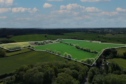
Chipping Warden, Daventry, Northamptonshire
- Land size
- 63.44 acres
Key Features
- A compact block of desirable grade 3 arable land
- Divided into three usable enclosures
- With mature hedgerows and treed boundaries
- Good road frontage onto the West Farndon road
- Slightly acid loamy and clayey soils
- Well suited to autumn sown crops and grassland
- The soils have been well managed
- Sensitively farmed in a cereal rotation
Description
An interesting block of arable land with good road frontage. Extending to about 63.44 acres (25.67 ha) in all.
A compact block of desirable grade 3 arable land.
Divided into three usable enclosures, with mature hedgerows and treed boundaries.
Good road frontage onto the West Farndon road.
Land Quality and Soil Type
According to Soilscape (England) the soils may be described as slightly acid loamy and clayey soils. Such soils are well suited to autumn sown crops and grassland.
The soils have been well managed as is evident upon inspection. The majority of the land has been sensitively farmed in a cereal rotation for a number of years. Further cropping details upon request.
Situation
The village of Woodford Halse is only 1 mile away. The thriving community offers an excellent range of day-to-day amenities, including a Co-op, post office, butchers, pharmacy, a well-regarded primary school, and several public houses.
Leisure and sporting facilities are also available within the village. Close by are state and private schooling.
Banbury is 10 miles to the south, with convenient access to the M40 and trains to London Marylebone around an hour
Daventry to the north is 9 miles, beyond which is access to the M1, and Long Buckby station for journeys north.
Services
No services are connected. Prospective purchasers must satisfy themselves as to the availability of services and any future connections.
Tenure
The land is to be sold freehold with vacant possession, subject to a contract farming agreement which ends on 30th September 2026.
Method of sale
The land is offered for sale by Private Treaty method. However the vendor reserves the right to conclude the sale by an alternative method if required.
Local Authority
West Northamptonshire Council
Land Quality and Soil Type
The soils have been well managed as is evident upon inspection. The majority of the land has been sensitively farmed in a cereal rotation for a number of years. Further cropping details upon request.
Public rights of way, wayleaves and easements
The land is sold subject to all rights of way, wayleaves and easements whether or not they are defined in this brochure.
The land benefits from road frontage and access to the south. There is a public bridleway which crosses the land on the outer edge of the northern boundary. The property is sold subject to all other rights of way, wayleaves and easements so far as they exist.
Basic Payment Scheme and Sustainable Farming Incentive
The land has historically been registered for payments under the Basic Payment Scheme and all delinked payments relevant to the land will be retained by the vendor and will not be available to the purchaser/s on completion of the sale.
There is a Mid Tier Countryside Stewardship scheme which expires in December 2026.
Ingoing Crop Valuation and Holdover
If required, provision may need to be made for holdover and an ingoing valuation of the growing crops.
Planning
The selling agents will not provide advice/guidance on the planning history for the property/land. Interested parties are advised to make their own investigations. It is assumed that enquiries have been satisfied, prior to an offer being made.
Anti Money Laundering Regulations (AML)
In accordance with Anti Money Laundering Regulations (AML), we are required to request forms of identification and carry out due diligence on any parties connected to a successful offer. Should an offer be made on behalf of a business/company, AML due diligence will also be necessary. Proof/source of funding must be supplied, prior to offer acceptance.
Plans and boundaries
The plans within these particulars are based on Ordnance Survey data and provided for reference only. They are believed to be correct but accuracy is not guaranteed. The purchaser shall be deemed to have full knowledge of all boundaries and the extent of ownership. Neither the vendor nor the vendor’s agents will be responsible for defining the boundaries or the ownership thereof.
Viewings
Strictly by appointment through Fisher German LLP.
Directions
Postcode – OX17 1AL
what3words – ///reference.stop.scales
Map Location
Property details
- Tenure
- Freehold
- Council Tax Band
- TBC
- Date Posted
- 2026-06-03
Market Value Analysis
Compared with 35 Farmland & Pasture listings in East Midlands (50+ acres).
Utilities & Restrictions
Utilities
- Electricity
- Ask Agent
- Water
- Ask Agent
- Heating
- Ask Agent
- Broadband
- Ask Agent
- Sewerage
- Ask Agent
Rights & Restrictions
- Public Rights of Way
- Ask Agent
- Private Rights of Way
- Ask Agent
- Listed Property
- Ask Agent
- Restrictions
- Ask Agent
Property Features
- Accessibility
- Ask Agent
- Parking
- Ask Agent
- Garden
- Ask Agent
Important notice: Information, maps and tags on this page are supplied by the advertising agent or generated automatically. LandSale has not verified them. Relying on these details is at your own risk, always carry out independent checks before committing to a purchase.
LandSale full disclaimer
Marketing information only - not formal particulars. The details on this website are provided for general guidance and do not constitute an offer or contract. Neither LandSale nor the advertising estate/land agent accepts responsibility for any inaccuracy.
1. Source of information
- Agent-supplied content: Core description, asking price, tenure, measurements, photographs and planning history are uploaded by the appointed agent, who remains solely responsible for their accuracy.
- Automated tags & categorisation: Property type, land-use class, acreage bands and similar labels may be applied by machine-learning models. They are intended as a helpful guide only and may not reflect the property's legal status or permitted use.
- Third-party & enriched data layers: Maps, boundary outlines, planning designations, soil reports, broadband coverage and other environmental or location-based insights are licensed from external suppliers. Such data are supplied “as is", may be incomplete or out of date and are subject to change without notice.
2. Verification required
Prospective purchasers must verify critical matters, including but not limited to planning permission, title boundaries, public rights of way, environmental constraints, acreage, services, access and VAT status, through their own inspections, specialist surveys, legal advisers and the selling agent before relying on the information or entering into any contract.
3. No warranty or liability
LandSale gives no warranty, express or implied, as to the accuracy, completeness or fitness for any particular purpose of the information displayed. LandSale shall not be liable for any loss, damage, cost or expense arising directly or indirectly from any use of or reliance on such information, save where liability may not be excluded by law.
4. Updates & feedback
If you believe any detail on this listing is inaccurate, please let us know. We will investigate and, where appropriate, update the listing or notify the agent.
© LandSale | Version 1.2 - January 2026
Listing agent
Fisher German, Covering South East
Covering South East
Similar properties for sale
- Price
- Guide Price£825,000
- Size
- 65.8 acres
Dodford, Northampton, Dodford, West Northamptonshire NN7 4TA England
Added on 20/07/2026Arable Land
- Price
- Guide Price£710,000
- Size
- 64.61 acres
Pastureland Off The Ridgeway, Barby, CV23 8UH, Barby, West Northamptonshire CV23 8UR England
Added on 28/01/2026Pasture
- Price
- Guide Price£650,000
- Size
- 51.68 acres
Spinmey Farm, Elmesthorpe, LE9, Elmesthorpe, Leicestershire LE9 7SG England
Added on 29/01/2026Grazing Land
- Price
- Offers in Excess of£900,000
- Size
- 84.63 acres
Coleshill, Birmingham, Coleshill, Warwickshire B46 1AJ England
Added on 11/06/2026Farm
- Price
- Guide Price£865,000
- Size
- 64.86 acres
Added on 29/01/2026Farmland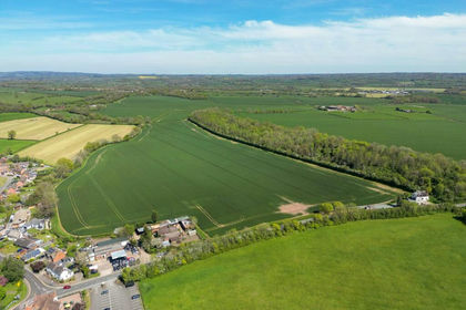
- Price
- Guide Price£600,000
- Size
- 45.67 acres
Hanbury, Bromsgrove, Worcestershire, Hanbury, Worcestershire B60 4DA England
Added on 04/07/2026Farmland
- Price
- Guide Price£600,000
- Size
- 67.36 acres
Arable & Pasture Land at Bisbrooke, Rutland - about 67.36 acres, Bisbrooke, Rutland LE15 9FJ England
Added on 03/06/2026Farmland
- Price
- Guide Price£700,000
- Size
- 41.23 acres
Quarry Lane, Snarestone, DE12, Snarestone, Leicestershire DE12 7DB England
Added on 19/05/2026Arable Land