
Bow, Crediton, EX17
- Land size
- 129.98 acres
Key Features
- Productive run of arable and pasture land
- Combination of Grade 2, 3 and 4 with Devon Red Soils
- Planning permission for an agricultural building
- River frontage
- Freehold
- In all about 129.98 acres
Description
Situation
Situated just outside the village of Bow in the heart of Mid Devon, the land occupies an attractive and accessible rural position within a productive farming area. Whilst the land lies close to the villages of Bow, Spreyton and Copplestone, the market town of Crediton lies just 7 miles east and provides a good range of everyday amenities and agricultural services. The Cathedral city of Exeter, just 5 miles beyond Crediton offers an extensive range of commercial and retail facilities. The property also benefits from good access to the wider road network, with links to the M5 motorway facilitating travel throughout the South West and beyond.
Description
The land extends to approximately 129.98 acres and comprises a productive block of predominantly arable land with one field laid to pasture, all well suited to modern commercial farming operations. A band of red land soil runs through the centre of the holding being widely regarded for its productive qualities and ability to support consistent cropping performance. The land is highly capable of growing a wide variety of cereal and fodder crops and has been farmed as part of a considered arable rotation in recent years. Part of the holding is currently drilled to wheat, the remainder (other than one pasture field) recently drilled to maize.
The land is classified as Grades 2, 3 and 4 according to the Agricultural Land Classification Maps and comprises predominantly free-draining loamy soils.
The combination of soil type, accessibility and field layout creates an efficient and practical unit.
The seller has successfully obtained planning permission for the construction of an agricultural building. Further information can be found via the Mid Devon Planning Portal 23/00454/FULL
Access to the property is via the public highway on the eastern boundary. The northern boundary is bordered by the River Yeo.
Other Information
Tenure: The land is being sold freehold, subject to vacant possession upon harvest of the maize crop.
Farm Plan: The farm plan is based on ordnance survey extracts, and the areas are not guaranteed and purchasers must satisfy themselves as to their accuracy.
Easements, Wayleaves, Rights of Way: The property is offered for sale, subject to and with the benefit of all matters contained in or referred to in the Property and Charges Register of the registered title together with all public or private rights of way, wayleaves, easements and other rights of way, which cross the property.
Boundaries: Any purchaser shall be deemed to have full knowledge of all boundaries and neither vendor nor the vendor’s agents will be responsible for defining the boundaries or the ownership thereof. Should any dispute arise as the boundaries or any points on the particulars or plans or the interpretation of them, the question shall be referred to the vendors agent whose decision acting as experts shall be final.
Services: It is understood that mains water is available but not connected.
Local Authority: Mid Devon District Council.
Health & Safety: Potential purchasers should be vigilant and take particular care when inspecting the property.
Viewings: Strictly by appointment with the selling agent, Kivells.
Directions
Postcode - EX17 6HZ
What3words - ///rally.directs.reclusive
Contact Us
Kivells, Farms & Land Department, Exeter
or
Ben Hancock
or ben.
Disclaimer
Kivells, their clients and any joint agents give notice that they are not authorised to make or give representations or warranties in relation to the property. No responsibility is accepted for any statement within these particulars, which do not form part of any offer or contract. Areas, measurements and boundaries are approximate. Text, photographs, CGI’s and plans are for guidance only. It should not be assumed the property has all necessary planning or building consents, and Kivells have not tested any services or equipment. The property is sold subject to all matters in the Property and Charges Register, including rights of way and easements. Purchasers are deemed to know all boundaries. Nothing herein constitutes financial advice; seek your own. Use of Mortgage Genies SW Ltd. will result in a £250 + VAT referral fee to Kivells. Kivells retains copyright to all particulars and media.
Map Location
Property details
- Tenure
- Freehold
- Council Tax Band
- D
- Date Posted
- 2026-06-02
Market Value Analysis
Compared with 8 Farmland & Pasture listings in South West England (100+ acres).
Utilities & Restrictions
Utilities
- Electricity
- Ask Agent
- Water
- Ask Agent
- Heating
- Ask Agent
- Broadband
- Ask Agent
- Sewerage
- Ask Agent
Rights & Restrictions
- Public Rights of Way
- Ask Agent
- Private Rights of Way
- Ask Agent
- Listed Property
- Ask Agent
- Restrictions
- Ask Agent
Property Features
- Accessibility
- Ask Agent
- Parking
- Ask Agent
- Garden
- Ask Agent
Important notice: Information, maps and tags on this page are supplied by the advertising agent or generated automatically. LandSale has not verified them. Relying on these details is at your own risk, always carry out independent checks before committing to a purchase.
LandSale full disclaimer
Marketing information only - not formal particulars. The details on this website are provided for general guidance and do not constitute an offer or contract. Neither LandSale nor the advertising estate/land agent accepts responsibility for any inaccuracy.
1. Source of information
- Agent-supplied content: Core description, asking price, tenure, measurements, photographs and planning history are uploaded by the appointed agent, who remains solely responsible for their accuracy.
- Automated tags & categorisation: Property type, land-use class, acreage bands and similar labels may be applied by machine-learning models. They are intended as a helpful guide only and may not reflect the property's legal status or permitted use.
- Third-party & enriched data layers: Maps, boundary outlines, planning designations, soil reports, broadband coverage and other environmental or location-based insights are licensed from external suppliers. Such data are supplied “as is", may be incomplete or out of date and are subject to change without notice.
2. Verification required
Prospective purchasers must verify critical matters, including but not limited to planning permission, title boundaries, public rights of way, environmental constraints, acreage, services, access and VAT status, through their own inspections, specialist surveys, legal advisers and the selling agent before relying on the information or entering into any contract.
3. No warranty or liability
LandSale gives no warranty, express or implied, as to the accuracy, completeness or fitness for any particular purpose of the information displayed. LandSale shall not be liable for any loss, damage, cost or expense arising directly or indirectly from any use of or reliance on such information, save where liability may not be excluded by law.
4. Updates & feedback
If you believe any detail on this listing is inaccurate, please let us know. We will investigate and, where appropriate, update the listing or notify the agent.
© LandSale | Version 1.2 - January 2026
Listing agent
Kivells, Exeter Land & Farm Sales
The Matford Centre, Matford Park Road, Exeter, Devon, EX2 8FD
View agent profileSimilar properties for sale

- Price
- Offers in Region of£700,000
- Size
- 14 acres
Added on 09/07/2026Building Plot
- Price
- £750,000
- Size
- 2754.35 acres
Didworthy, South Brent, Devon, TQ10 9EL, South Brent, Devon TQ10 9EL England
Added on 23/06/2026Grazing Land
- Price
- Guide Price£1,400,000
- Size
- 141.4 acres
Minions, Liskeard, PL14, St. Cleer, Cornwall PL14 6ER England
Added on 04/06/2026Farm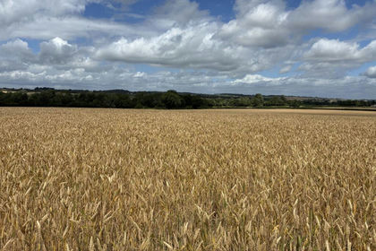
- Price
- Guide Price£690,000
- Size
- 54.4 acres
Land at Isle Abbotts Taunton, Somerset, TA3 6RR, Isle Abbotts, Somerset TA3 6RR England
Added on 17/07/2026Arable Land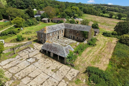
- Price
- Guide Price£750,000
- Size
- 19.9 acres
Lower Boscarne, Nanstallon, PL30, Lanivet, Cornwall PL30 5LG England
Added on 30/06/2026Redevelopment Land
- Price
- Guide Price£1,050,000
- Size
- 104.84 acres
Hillgrove Road, Green Ore, Wells, Somerset, BA5, Priddy, Somerset BA5 3AN England
Added on 21/05/2026Farm
- Price
- Offers in Region of£695,000
- Size
- 108.08 acres
Sylen Road, Pontyberem, SA15, Pontyberem, Carmarthenshire SA15 5NW Wales
Added on 29/01/2026Agricultural Land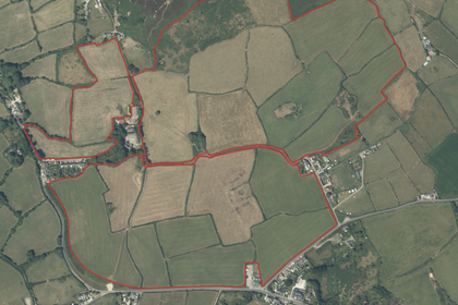
- Price
- Guide Price£1,000,000
- Size
- 108 acres
Land at Bosleake Farm, Bosleake Row, Carn Brea, Cornwall, Carn Brea, Cornwall TR15 3YG England
Added on 17/07/2026Farm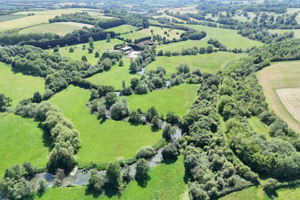
- Price
- £1,450,000
- Size
- 134.81 acres
Sporting Land-135 acres, Beckington, Frome, BA11, Beckington, Somerset BA11 6TE England
Added on 07/06/2026Recreational Land
- Price
- Guide Price£1,450,000
- Size
- 134.81 acres
Stubbs Lane, Beckington, Frome, Beckington, Somerset BA11 6TE England
Added on 07/06/2026Recreational Land