Sylen Road, Pontyberem, SA15
- Land size
- 108.08 acres
Key Features
- Significant environmental appeal
- Valuable block of land in a convenient location
- Currently used for grazing and cropping purposes in parts
- 108 acres or thereabouts of agricultural land
- Superb opportunity to develop a conservation project etc.
Description
Extending in total to 108.08 acres or thereabouts which is naturally divided by a single track lane which provides good accessibility to the land. Of the total area we would consider some 90 acres or thereabouts to be suitable for agricultural production. Currently used for both grazing and cropping purposes, the land does vary in topography from level to gently sloping and includes areas of mature woodland and a ruin is also situated within the land's boundary. Historically the land has been farmed organically and does include an area of heavier peat land. An excellent opportunity to acquire a large block of land which offers both agricultural and environmental appeal.
Schedule of Acreage
Areas taken from the Single Application Form.
Services
Natural spring water supply but a mains water pipe does run through the land, but is not currently connected.
Tenure: Freehold with vacant possession upon completion.
Local Authority: Carmarthenshire County Council.
Entitlements: To be included within the sale of the land.
Pictures: Drone photography was taken in the summer of 2024.
Pylons: Please note that two towers are located on the land.
Plans
The plans are published for illustrative purposes only and although they are believed to be correct, their accuracy is not guaranteed.
Wayleaves, Easements and Rights of Access: The land is offered for sale subject to all existing rights including rights of way, whether public or private, light, support, drainage, water, gas, electricity supplies, and mineral rights, easements, quasi-easements or wayleaves whether or not referred to in these particulars.
General Remarks
An excellent opportunity to acquire a large parcel of agricultural land mainly in a ring fence which offers cropping and grazing land together with areas of amenity land which offer significant environmental appeal and would be ideally suited to those looking to embark on a carbon capture project.
Directions
The postcode for the farm is SA15 5NW and the land is situated opposite the farm entrance. From the direction of Crosshands proceed along the 'A476' roadway signposted Llanelli, passing through the village of Upper Tumble (before reaching the village of Llannon) take a right hand turn at the next crossroads, continue along this road for a short journey, taking the next right hand turn onto the 'B4306' roadway and continue along this road for a mile or so until you take a left hand turn into Heol Bethel. Continue along this road taking a right hand turn which is signposted 'Low Bridge 1 mile ahead' and the property will be located on the left hand side, the farm name is displayed at the entrance to the property and the land is situated opposite the farm entrance.
what3words ///tinsel.unafraid.infringe - provides the location of field SN5009 6885
Broadband Availability.
According to the Ofcom website, this property has standard broadband available with speeds up to Standard 1 Mbps upload and 8 Mbps download. Please note this data was obtained from an online search conducted on ofcom.org.uk and was correct at the time of production. Some rural areas are yet to have the infrastructure upgraded and there are alternative options which include satellite and mobile broadband available. Prospective buyers should make their own enquiries into the availability of services with their chosen provider.
Mobile Phone Coverage.
The Ofcom website states that the property has the following indoor mobile coverage
EE Voice - Limited & Data - Limited
Three Voice - Limited & Data - Limited
O2 Voice - Likely & Data - Limited
Vodafone Voice - Limited & Data - Limited
Results are predictions and not a guarantee. Actual services available may be different from results and may be affected by network outages. Please note this data was obtained from an online search conducted on ofcom.org.uk and was correct at the time of production. Prospective buyers should make their own enquiries into the availability of services with their chosen provider.
Anti Money Laundering and Ability To Purchase
Please note when making an offer we will require information to enable us to confirm all parties identities as required by Anti Money Laundering (AML) Regulations. We may also conduct a digital search to confirm your identity.
We will also require full proof of funds such as a mortgage agreement in principle, proof of cash deposit or if no mortgage is required, we will require sight of a bank statement. Should the purchase be funded through the sale of another property, we will require confirmation the sale is sufficient enough to cover the purchase.
Map Location
Property details
- Tenure
- Freehold
- Council Tax Band
- Ask Agent
- Date Posted
- 2026-01-29
Market Value Analysis
Compared with 14 Farmland & Pasture listings in Wales (100+ acres).
Utilities & Restrictions
Utilities
- Electricity
- Ask Agent
- Water
- Ask Agent
- Heating
- Ask Agent
- Broadband
- Ask Agent
- Sewerage
- Ask Agent
Rights & Restrictions
- Public Rights of Way
- Ask Agent
- Private Rights of Way
- Ask Agent
- Listed Property
- Ask Agent
- Restrictions
- Ask Agent
Property Features
- Accessibility
- Ask Agent
- Parking
- Ask Agent
- Garden
- Ask Agent
Important notice: Information, maps and tags on this page are supplied by the advertising agent or generated automatically. LandSale has not verified them. Relying on these details is at your own risk, always carry out independent checks before committing to a purchase.
LandSale full disclaimer
Marketing information only - not formal particulars. The details on this website are provided for general guidance and do not constitute an offer or contract. Neither LandSale nor the advertising estate/land agent accepts responsibility for any inaccuracy.
1. Source of information
- Agent-supplied content: Core description, asking price, tenure, measurements, photographs and planning history are uploaded by the appointed agent, who remains solely responsible for their accuracy.
- Automated tags & categorisation: Property type, land-use class, acreage bands and similar labels may be applied by machine-learning models. They are intended as a helpful guide only and may not reflect the property's legal status or permitted use.
- Third-party & enriched data layers: Maps, boundary outlines, planning designations, soil reports, broadband coverage and other environmental or location-based insights are licensed from external suppliers. Such data are supplied “as is", may be incomplete or out of date and are subject to change without notice.
2. Verification required
Prospective purchasers must verify critical matters, including but not limited to planning permission, title boundaries, public rights of way, environmental constraints, acreage, services, access and VAT status, through their own inspections, specialist surveys, legal advisers and the selling agent before relying on the information or entering into any contract.
3. No warranty or liability
LandSale gives no warranty, express or implied, as to the accuracy, completeness or fitness for any particular purpose of the information displayed. LandSale shall not be liable for any loss, damage, cost or expense arising directly or indirectly from any use of or reliance on such information, save where liability may not be excluded by law.
4. Updates & feedback
If you believe any detail on this listing is inaccurate, please let us know. We will investigate and, where appropriate, update the listing or notify the agent.
© LandSale | Version 1.2 - January 2026
Listing agent
JJ Morris, Narberth
Hill House High Street, Narberth, SA67 7AR
Similar properties for sale

- Price
- £550,000
- Size
- 70 acres
Llangyndeyrn, Kidwelly, SA17, Llangyndeyrn, Carmarthenshire SA17 5ER Wales
Added on 05/03/2026Farmland
- Price
- £675,000
- Size
- 91.22 acres
Pencarreg, Llanybydder, SA40, Pencarreg, Carmarthenshire SA40 9QG Wales
Added on 17/02/2026Farmland
- Price
- £545,000
- Size
- 99 acres
Added on 15/04/2026Vacant Land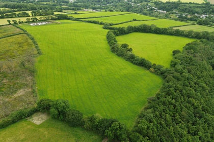
- Price
- £650,000
- Size
- 66.5 acres
Cenarth, Newcastle Emlyn, SA38, Cenarth, Carmarthenshire SA38 9JN Wales
Added on 26/06/2026Farmland
- Price
- Guide Price£600,000
- Size
- 227 acres
Rhandirmwyn, Llandovery, Llanfair-ar-y-bryn, Carmarthenshire SA20 0PB Wales
Added on 29/01/2026Mountain Land
- Price
- £750,000
- Size
- 77.4 acres
Plwmp, Llandysul, SA44, Llandysiliogogo, Ceredigion SA44 6HT Wales
Added on 28/01/2026Farmland