Plaish, Church Stretton, Shropshire
- Land size
- 57.55 acres
Description
UPON KIND INSTRUCTIONS OF MR & MRS A BRADSHAW
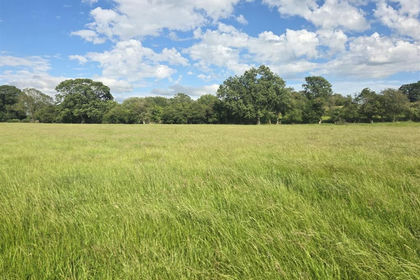
An excellent block of productive pastureland, set within a ring fence with natural water supplies, amounting to approximately 57.55 acres (23.29 hectares), within the renowned Shropshire Hills farming region. Providing an excellent opportunity to acquire a practical and versatile agricultural unit in a highly sought-after rural setting, ideal for stock rearing benefiting from a concrete yard/handling area and two useful barns, offering storage, livestock shelter or potential scope for diversification (subject to the necessary consents). Enjoying outstanding far-reaching views across the rolling Shropshire countryside.
- Good Roadside Frontage
- Productive, Level and Gently Undulating
- Natural Water Supplies
- Situated approximately 8.5 miles east of the market town of Church Stretton, with good road links to the A49
- Future opportunities for investment in natural capital, carbon sequestration and biodiversity.
For sale by Informal Tender (subject to prior sale) as a whole.
Tenders close Friday 17th July 2026 at 12 noon.
LAND AT HOLD PREEN, PLAISH
The land is situated in the rolling unspoilt countryside on the edge of the Shropshire Hills National Landscape, adjacent to the renown Wenlock Edge and Holt Preen Manor, which is believed to date back to the 1600s, an attractive blend of natural beauty and historic character. It lies within conveniently sized enclosures, suitable for livestock grazing, grassland conservation practices, and machinery cultivations, extending in total to approximately 57.55 acres (23.29 hectares) as shown delineated red on the attached plan, offering a productive block of level to gently sloping and undulating improved permanent pasture.
.
The land is bound by mature hedgerows and stockproof fences boundaries with direct access onto the council-maintained highway leading from the village of Longville in the Dale towards the hamlet of Plaish. There are multiple interspersed trees within the holding, as well as an adjoining woodland edge providing shelter and biodiversity. The land benefits from natural water supplies via the stream situated within the wooded dingle area. The majority of the land lies the far side of the stream, with all parcels being easily accessible, forming a practical ring-fenced grazing unit.
..
The land has been currently used for livestock production, capable of producing good quality livestock with excellent stocking capabilities, within this renowned farming area. The land leads itself to a variety of uses including agriculture, amenity, equestrian, tourism and offers future opportunities for investment in natural capital, carbon sequestration and biodiversity.
...
Plaish is a small and peaceful hamlet approximately 8.5 miles from the scenic market town of Church Stretton often referred to as Little Switzerland, which is ideally placed midway between the county town of Shrewsbury and the renowned historic town of Ludlow. The town has direct access to 20 square miles of National Trust owned land known as the Long Mynd. The town offers a comprehensive range of everyday and specialist shops with a full range of facilities. There is a mainline railway station with connections to London and a dual carriageway link at Shrewsbury to the national motorway system.
....
The land also benefits from a useful, secure concrete yard / handling area with gated access, ideal for practical stock management. There are also two buildings, one being timber pole construction, with a concrete block walls and corrugated iron sheeting over, and a corrugated iron roof, providing gated access at either end, allowing ease of movement for livestock and machinery. The second building is a steel portal-framed structure, with a corrugated iron roof and breeze block walls.
SPORTING & MINERAL RIGHTS
These are in hand and will pass with the sale of the freehold.
TIMBER
All standing timber is included in the sale.
RURAL PAYMENT AGENCY & POLICY
We have been informed that the property is registered with the Rural Payment Agency (RPA). The land is entered into a Countryside Stewardship Mid-Tier agreement which expires on 31st December 2026, and the successful purchaser will be required to comply to the specification of the scheme until expiry, with the vendor will be retaining the payments received for the duration.
TENURE
We have been informed that the land is freehold, with vacant possession given on completion.
FIXTURES AND FITTINGS
Those items mentioned in the sale particulars are included in the freehold sale. All other fixtures and fittings are expressly excluded.
EASEMENTS, WAYLEAVES AND RIGHTS OF WAY
The land is offered subject to, and with the benefit of, any rights-of-way both public and private, all wayleaves, easements and other rights whether or not specifically referred to. There is an internet mast placed upon the land for the benefit of the adjacent Holt Preen Manor. There is also a waterpipe easement providing the Holt Preen Manor development, together with a water holding tank.
TOWN AND COUNTRY PLANNING
The land is offered subject to any development plans, tree preservation orders, ancient orders, public rights-of-way, town planning schedules, or resolutions which may be or may come into force. The purchaser(s) will be deemed to have full knowledge of these and have satisfied themselves as to the effects such matters have on the land.
GUIDE PRICE
£460,000
SOLICITORS
David Raymont, MFG Solicitors, Telford / david.
AUTHORITIES
Shropshire Council: Rural Payment Agency:
PLANS, AREAS AND SCHEDULES
These are based on Ordnance Survey and are for reference only. They have been checked and compiled by the vendor’s agents and the purchaser(s) shall be deemed to have satisfied themselves as to the description of the property. Any error or misstatement shall not annul a sale or entitle any party to compensation in respect thereof.
BOUNDARIES, ROADS AND FENCES
The purchaser(s) shall be deemed to have full knowledge of the boundaries and neither the Vendor nor the Vendors agents will be responsible for defining the boundaries of ownership thereof.
WHAT3WORDS
///ranks.resorting.spectacle
VIEWINGS AND HEALTH AND SAFETY
Strictly by appointment through the selling agents. The agents advise all prospective purchasers when viewing the land to take due care.
METHOD OF SALE
The land is offered for sale as a whole by Informal Tender (unless previously sold). The tender forms will be available from the Vendor’s agents. Tenders close Friday 17th July at 12 noon. Tenders are to be delivered to; McCartneys LLP, Corvedale Road, Craven Arms, Shropshire, SY7 9NE marked “Tender – Land at Holt Preen, Nr Plaish”. The Vendor reserves the right not to accept the highest, or indeed, any offer. The Vendor reserves the right to accept offers prior to the tender date.
ANTI MONEY LAUNDERING
The successful purchaser should please provide a photographic form of ID such as driver’s licence or passport, and a utility bill or bank statement confirming their home address.
IMPORTANT NOTICE
McCartneys, for themselves and for the Vendor of this land and any joint agents give notice that; 1. These particulars are intended for guidance only. They are prepared and issued in good faith and are intended to give a fair description but do not constitute part of an offer or contract. Any information should not be relied on as statement or representation of fact or that the property or its services are in good condition.
.....
2. McCartneys have not made any investigations into the existence or otherwise of any issues concerning pollution and potential land, air and water contamination, the purchaser is responsible for making his/her own enquiries in this regard. 3. Neither McCartneys nor any of their employees have authority to make or give any representation or warranty whatsoever in relation to the property
......
4. The images show only certain parts and aspects of the property at the time they were taken/created. 5. Any areas, measurements or distances given are approximate only. Any plans are for identification purposes only.
.......
6. Any reference to alterations to, or use of, any part of the property is not a statement that any necessary planning, building regulations or other consents have been obtained. An intending purchaser must verify these matters. Potential purchaser(s) should not rely upon the use stated in these particulars and should check their proposed use with the relevant planning authority to ensure it is permitted.
Map Location
Property details
- Tenure
- Freehold
- Council Tax Band
- TBC
- Date Posted
- 2026-06-02
Utilities & Restrictions
Utilities
- Electricity
- Ask Agent
- Water
- Ask Agent
- Heating
- Ask Agent
- Broadband
- Ask Agent
- Sewerage
- Ask Agent
Rights & Restrictions
- Public Rights of Way
- Ask Agent
- Private Rights of Way
- Ask Agent
- Listed Property
- Ask Agent
- Restrictions
- Ask Agent
Property Features
- Accessibility
- Ask Agent
- Parking
- Ask Agent
- Garden
- Garden
Important notice: Information, maps and tags on this page are supplied by the advertising agent or generated automatically. LandSale has not verified them. Relying on these details is at your own risk, always carry out independent checks before committing to a purchase.
LandSale full disclaimer
Marketing information only - not formal particulars. The details on this website are provided for general guidance and do not constitute an offer or contract. Neither LandSale nor the advertising estate/land agent accepts responsibility for any inaccuracy.
1. Source of information
- Agent-supplied content: Core description, asking price, tenure, measurements, photographs and planning history are uploaded by the appointed agent, who remains solely responsible for their accuracy.
- Automated tags & categorisation: Property type, land-use class, acreage bands and similar labels may be applied by machine-learning models. They are intended as a helpful guide only and may not reflect the property's legal status or permitted use.
- Third-party & enriched data layers: Maps, boundary outlines, planning designations, soil reports, broadband coverage and other environmental or location-based insights are licensed from external suppliers. Such data are supplied “as is", may be incomplete or out of date and are subject to change without notice.
2. Verification required
Prospective purchasers must verify critical matters, including but not limited to planning permission, title boundaries, public rights of way, environmental constraints, acreage, services, access and VAT status, through their own inspections, specialist surveys, legal advisers and the selling agent before relying on the information or entering into any contract.
3. No warranty or liability
LandSale gives no warranty, express or implied, as to the accuracy, completeness or fitness for any particular purpose of the information displayed. LandSale shall not be liable for any loss, damage, cost or expense arising directly or indirectly from any use of or reliance on such information, save where liability may not be excluded by law.
4. Updates & feedback
If you believe any detail on this listing is inaccurate, please let us know. We will investigate and, where appropriate, update the listing or notify the agent.
© LandSale | Version 1.2 - January 2026
Listing agent
McCartneys LLP, Craven Arms
Corvedale Road, Craven Arms, SY7 9NE
Similar properties for sale
- Price
- Guide Price£515,000
- Size
- 37.29 acres
Land at Parknasilla, Horsebridge Road, Minsterley, SY5 0AQ, Minsterley, Shropshire SY5 0AG England
Added on 04/07/2026Vacant Land
- Price
- Offers in Region of£275,000
- Size
- 41.92 acres
Land at Meadowtown, Shrewsbury, Worthen with Shelve, Shropshire SY5 0DZ England
Added on 29/01/2026Grazing Land
- Price
- Guide Price£3,900,000
- Size
- 357 acres
Land at Bigwood Farm, Beckbury, Shifnal, TF11 9DG, Badger, Shropshire WV6 7JS England
Added on 02/06/2026Farmland
- Price
- Guide Price£575,000
- Size
- 47.77 acres
Land known as Land at Cwm Meadows, Churchstoke, Churchstoke, Powys SY15 6TH Wales
Added on 20/03/2026Grazing Land
- Price
- £1,050,000
- Size
- 107.08 acres
Land at White House Farm, Weston Lullingfields, Shrewsbury, Baschurch, Shropshire SY4 2AP England
Added on 11/07/2026Agricultural Land
- Price
- Sale by Tender
- Size
- 135.39 acres
Added on 02/06/2026Grazing Land
- Price
- £560,000
- Size
- 56.44 acres
Lot 5, Parsonage Farm, Kyre, Tenbury Wells, Worcestershire, Kyre, Worcestershire WR15 8RL England
Added on 16/05/2026Farm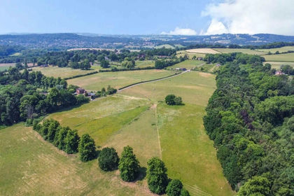
- Price
- Guide Price£650,000
- Size
- 64.71 acres
Added on 02/07/2026Equestrian property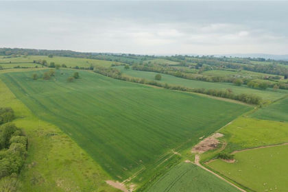
- Price
- £1,675,000
- Size
- 134.31 acres
Lot 4, Parsonage Farm, Kyre, Tenbury Wells, Worcestershire, Kyre, Worcestershire WR15 8RW England
Added on 16/05/2026Farm
- Price
- £3,145,000
- Size
- 241.52 acres
Parsonage Farm, Kyre, Tenbury Wells, Worcestershire, Kyre, Worcestershire WR15 8RW England
Added on 14/05/2026Farm