Hay Lane, Horsley, GL6
- Land size
- 3.4 acres
- Bedrooms
- 4
- Bathrooms
- 2
Key Features
- AN EXTENDED SEMI DETACHED COTTAGE IN RURAL HORSLEY
- FOUR BEDROOMS
- THREE RECEPTION ROOMS
- BATH AND SHOWER ROOMS
- DETACHED STONE BARN ANNEXE
- DETACHED STABLE BLOCK
- PARKING FOR SEVERAL VEHICLES
- GARDENS AND GRAZING LAND WITH A TOTAL PLOT SIZE OF 3.4 ACRES
Description
Properties like The Orchard come to the market very rarely — not just because they are hard to find, but because the people who find them tend not to leave. Set in 3.4 acres off a country lane on the outskirts of the village of Horsley, the property is surrounded by rolling fields and open countryside. With grazing land, stabling, a detached barn annexe and various studio/ outbuildings, this is a home for someone looking to live a little differently.
The principal cottage was modest semi-detached stone building initially, full of character and interest shaped over generations. It has been extended sympathetically in the more recent past, retaining the warmth and feel of the original building whilst more than doubling the living space. You walk into a generous entrance hall, with a utility room with shower and WC tucked conveniently at the rear. To the left there is a 17’ reception room with wood burning stove. To the right, a 26’ kitchen/dining room, with Everhot stove and flagstone floors is the natural heart of the home. Two further reception rooms on the ground floor, one with a wood burning stove and a door out to the rear courtyard, means there is plenty of good living space for busy family life, offering flexibility as a study, playroom or snug as needs change over time.
A staircase leads up from the larger of these two rooms to the first floor. Here, a large landing connects four bedrooms, a study and a family bathroom. Two of the bedrooms interconnect, with an en suite shower room off. Glazed double doors open from the far room onto steps that lead back into the garden, and this area has been used as a small informal annexe in the past, although it’s likely that it will be earmarked as the parent’s suite, with bedroom, dressing room and shower room. The remaining bedrooms have plenty of character of their own, with sloping ceilings, deep-set windows and the kind of quiet that comes from being surrounded by open countryside on all sides. Separate from the main house, the detached barn annexe is a space quite unlike anything else. A vaulted, beamed interior with its own kitchen area, bathroom and a mezzanine bedroom reached by a ship's ladder, it has a warmth and personality that comes from years of creative occupation — the sort of place that people fall in love with the moment they walk in. With its own entrance, solar panel generated electricity and wood burning stove, it functions comfortably as accommodation away from the main property. For those with older children, elderly parents or simply a need for a properly separate guest space, it makes The Orchard a genuinely practical proposition for multi-generational living in a way that few properties in this price range can match.
Taken together, the main house and annexe offer approximately 2,315 square feet of living space. In addition, there is an insulated detached studio outbuilding, a summerhouse and other useful sheds, stores and outbuildings, adding to a versatile home that is greater than the sum of its parts. Flexible, characterful and totally unique, The Orchard is full of potential for a family ready to put their own stamp on a very special place.
The Orchard forms the left-hand side of a row of three buildings which are believed to have originally been weavers’ cottages, later becoming cider storage sheds when the central building briefly served as a Georgian public house. Since that time the cider apple trees were removed and more recently the kitchen, constructed cowshed roof in the barn by German journeymen, stables, and extension to the main house with external staircase.
Entering Orchard House from Hay lane, the driveway curves round a substantial lawn or green, with a variety of trees some of which are relatively rare and are labelled. On the right is a fruit cage, tied entrance, the curved turf roofed stable, workshop and garage building (topped with solar panels), access to the apple orchard, a pond, and access to the second field. This has been recently planted (partially to stabilise the soil), as a deciduous park. Passing The Barn annexe and some wood storage containers , one ends up eventually facing the house. There is also a small raw wool insulated shed, on the left. There is access to parking in a variety of places, to the studio, decking and area of land behind the barn, and to a second, somewhat shallow pond.
There are a substantial variety of unusual or rare trees, flower and shrub beds, and a no dig organic vegetable patch. Mature species trees include, Parrotia Persia, Davidia, Catalpa (Indian Bean Tree), Cedar, Golden Rain Tree and Caucasian wing nut. Apple varieties including Annie Elizabeth, Cox's Orange Pippin, Jupiter, Wyken Pippin, Blenheim Orange, Autumn Permain, Tydeman's Late Orange, Sunset, Braeburn, Falstaff, Gloucester Cross, Ashmead's Kernel, Canadian Reinette and Aromatic Russet. Solar panels sit atop the stable and these serve the house and annexe.
In all, the property extends to approximately 3.40 acres — a unique opportunity to live with the land in a setting that very rarely comes to the market.
The popular village of Horsley boasts a shop, church and primary school. The lively Cotswold town of Nailsworth is approximately 1½ miles away and has become an increasingly popular shopping destination within the Stroud Valleys benefiting from a large and comprehensive selection of speciality shops including Williams Food Hall, the famous Hobbs House Bakery, various clothing and gift shops, several cafes and a good selection of very well regarded restaurants. In addition to this the town currently benefits from three supermarkets, free parking and both state and private schooling in the area. Nailsworth is also home to Forest Green Rovers Football Club where there is a modern leisure/fitness centre. Bus services connect with Stroud, some 4 miles away, where there is a more comprehensive selection of shopping, educational and leisure facilities. Junctions of the M4 and M5 motorways are within easy reach and railway stations at Stroud (4 miles) and Kemble (10 miles) provide main line services to Gloucester, Swindon and London Paddington
Property information
The property is freehold. Oil fired central heating, mains electricity, water and private drainage. The council tax band is D. We have checked the service and reception levels available locally through the OFCOM network checker and the broadband services available include standard and ultrafast connections, and you are likely to have full service from all major mobile providers outside the property, although reception may be limited inside the house. These results are predictions and not a guarantee. Actual services available may be different depending on the particular circumstances and the precise location of the user.
Agents Note
There is a right of way for the neighbouring property over the drive. A small area of land will be retained by the seller. Please contact the office for more information.
Map Location
Property details
- Tenure
- Freehold
- Council Tax Band
- D
- Date Posted
- 2026-05-25
Market Value Analysis
Compared with 1,628 Homes with Land listings in South West England (1+ acres).
Energy Performance Certificate
Energy Efficiency Rating
Based on UK Energy Performance Certificate standards (EU Directive 2002/91/EC)
Running costs are one side. Planning activity, flood history and ground risks for this location are in the full report.
Utilities & Restrictions
Utilities
- Electricity
- Mains
- Water
- Mains
- Heating
- Oil Heating
- Broadband
- Full Fibre (FTTP)
- Sewerage
- Septic Tank / Private
Rights & Restrictions
- Public Rights of Way
- Ask Agent
- Private Rights of Way
- Ask Agent
- Listed Property
- Ask Agent
- Restrictions
- Ask Agent
Listed status, conservation areas and planning constraints for this location are in the full report.
Property Features
- Accessibility
- Ask Agent
- Parking
- Parking Available
- Garden
- Garden
Beyond the particulars: planning activity, flood history, heritage and ground risks, checked for this exact spot.
Connectivity
Broadband
Fastest speed available at this postcode
1 Gbps
Gigabit full fibre
Suitable for
- 4K streaming on every screen
- Full-time home working
- Online gaming & big downloads
Mobile signal
Predicted 4G and 5G signal; indoor signal depends on building materials.
Ofcom Connected Nations postcode-level predictions. Speeds and signal are modelled, not measured, and vary between addresses and providers.
Signal is the easy part. Planning activity, flood history and protected designations here are in the full report.
Nearest Schools
Primary
- Horsley Church of England Primary School578 metresOfsted: Good
- Ages
- 4 to 11
- Pupils
- 105
- Type
- Voluntary aided school
- Faith
- Church of England
- Nailsworth Church of England Primary School1.6 milesOfsted: Good *
- Ages
- 4 to 11
- Pupils
- 176
- Type
- Voluntary controlled school
- Faith
- Church of England
- Amberley Parochial School2.4 milesNo Ofsted rating
- Ages
- 4 to 11
- Pupils
- 104
- Type
- Academy converter
- Faith
- Church of England
- Avening Primary School2.5 milesNo Ofsted rating
- Ages
- 4 to 11
- Pupils
- 107
- Type
- Academy converter
- Minchinhampton Primary Academy2.8 milesOfsted: Good *
- Ages
- 3 to 11
- Pupils
- 260
- Type
- Academy converter
- Faith
- Church of England
Secondary
- Sir William Romney's School3.7 milesNo Ofsted rating
- Ages
- 11 to 16
- Pupils
- 495
- Type
- Academy converter
- Marling School4.8 milesOfsted: Good *
- Ages
- 11 to 18
- Pupils
- 1,082
- Type
- Academy converter
- Gender
- Boys
- Stroud High School4.8 milesOfsted: Outstanding
- Ages
- 11 to 18
- Pupils
- 1,144
- Type
- Academy converter
- Gender
- Girls
- Thomas Keble School5.2 milesNo Ofsted rating
- Ages
- 11 to 16
- Pupils
- 718
- Type
- Academy converter
- Archway School5.2 milesOfsted report card · Apr 2026
- Ages
- 11 to 18
- Pupils
- 1,053
- Type
- Community school
* Latest graded judgement covers quality of education only; no overall grade was issued under the 2024-25 inspection framework.
Distances are straight-line from the advertised location. Source: the national school registers (DfE, Welsh Government, Scottish Government) and Ofsted.
Schools are just the start: sold prices nearby, planning activity and any flood history are in the full report.
Amenities
Supermarket
GP surgery
Pharmacy
Hospital
Green space
Straight-line distances from the advertised location. Sources: NHS records, Geolytix supermarket locations, OS Open Greenspace and the national trails registers.
The area stacks up? Now check the location itself: planning nearby, protected designations and past flooding.
Getting Around
Nearest station
Nearest bus stop
Typical drive times
Straight-line distances from the advertised location; drive times are typical free-flow times over OpenStreetMap road data, so allow more at peak. Public transport locations from DfT NaPTAN.
Easy to reach matters. So do planning activity, flood history and ground risks: all in the full report.
Flood Risk
Environment Agency open data, checked around the advertised map pin for the listed acreage. Long-term risk counts flood defences; the planning map's flood zones do not. Provided by LandSale, not the listing agent, and not part of the agent's particulars. Risk varies across a holding, so verify before committing.
Rivers and the sea
Planning map: Flood Zone 1.
Surface water
These bandings are the summary. Where this location sits on the flood maps, plus planning activity, heritage and ground risks, is in the full report.
Important notice: Information, maps and tags on this page are drawn from the advertising agent's marketing materials or generated automatically. LandSale has not verified them. Relying on these details is at your own risk, always carry out independent checks before committing to a purchase.
LandSale full disclaimer
Marketing information only - not formal particulars. The details on this website are provided for general guidance and do not constitute an offer or contract. Neither LandSale nor the advertising estate/land agent accepts responsibility for any inaccuracy.
1. Source of information
- Listing content: Core description, asking price, tenure, measurements, photographs and planning history originate from the marketing materials of the advertising estate or land agent. LandSale does not author this content and cannot guarantee its accuracy.
- Automated tags & categorisation: Property type, land-use class, acreage bands and similar labels may be applied by machine-learning models. They are intended as a helpful guide only and may not reflect the property's legal status or permitted use.
- Third-party & enriched data layers: Maps, boundary outlines, planning designations, soil reports, broadband coverage and other environmental or location-based insights are licensed from external suppliers. Such data are supplied “as is", may be incomplete or out of date and are subject to change without notice.
2. Verification required
Prospective purchasers must verify critical matters, including but not limited to planning permission, title boundaries, public rights of way, environmental constraints, acreage, services, access and VAT status, through their own inspections, specialist surveys, legal advisers and the selling agent before relying on the information or entering into any contract.
3. No warranty or liability
LandSale gives no warranty, express or implied, as to the accuracy, completeness or fitness for any particular purpose of the information displayed. LandSale shall not be liable for any loss, damage, cost or expense arising directly or indirectly from any use of or reliance on such information, save where liability may not be excluded by law.
4. Updates & feedback
If you believe any detail on this listing is inaccurate, please let us know. We will investigate and, where appropriate, update the listing or notify the agent.
© LandSale | Version 1.3 - August 2026
Listing agent
Peter Joy Estate Agents, Nailsworth
14 Fountain Street, Nailsworth, GL6 0BL
View agent profileSimilar properties for sale
- Price
- Guide Price£875,000
- Size
- 3.82 acres
Coaley, Dursley, Gloucestershire, GL11, Coaley, Gloucestershire GL11 England
Added on 10/06/2026Farmhouse
- Price
- Guide Price£1,000,000
- Size
- 3.82 acres
Coaley, Dursley, Gloucestershire, GL11, Coaley, Gloucestershire GL11 England
Added on 08/07/2026Farmhouse
- Price
- Guide Price£785,000
- Size
- 4.73 acres
Cowcombe Lane, Chalford, Stroud, Gloucestershire, GL6, Minchinhampton, Gloucestershire GL6 England
Added on 14/06/2026House with Land
- Price
- Guide Price£875,000
- Size
- 3.5 acres
Cam Green, Cam, Dursley, GL11, Cam, Gloucestershire GL11 England
Added on 08/10/2026Smallholding
- Price
- £825,000
- Size
- 4.83 acres
Added on 11/06/2026House with Land
- Price
- Guide Price£850,000
- Size
- 6.9 acres
Edge, Stroud, Gloucestershire, GL6, Harescombe, Gloucestershire GL6 England
Added on 25/05/2026House with Land
- Price
- Guide Price£950,000
- Size
- 1.56 acres
The Little Paddock, Malmesbury, St. Paul Malmesbury Without, Wiltshire SN16 England
Added on 14/09/2026House with Land
- Price
- Guide Price£1,100,000
- Size
- 3 acres
Horton, South Gloucestershire, Horton, South Gloucestershire BS37 England
Added on 26/09/2026House with Land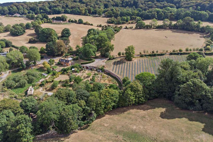
- Price
- Guide Price£1,100,000
- Size
- 5.79 acres
Added on 11/09/2026House with Land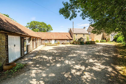
- Price
- Guide Price£1,100,000
- Size
- 11.5 acres
Added on 08/10/2026Smallholding