Hill Top Farm, Shap, Penrith, Cumbria
- Land size
- 15.12 acres
- Bedrooms
- 3
- Bathrooms
- 1
Key Features
- Good quality grazing/mowing land
- Three-bedroom farmhouse
- Extending in total to 15.12 acres (6.12 hectares)
- A range of agricultural farm buildings
- Available as a whole or in 4 lots
Description
A rare opportunity to acquire a former stock rearing farm situated within the village of Shap. OFFERS ARE TO BE SUBMITTED, ALONG WITH PROOF OF FUNDING, NO LATER THAN 12 NOON FRIDAY 3rd JULY 2026
OFFERS ARE TO BE SUBMITTED, ALONG WITH PROOF OF FUNDING, NO LATER THAN 12 NOON FRIDAY 3rd JULY 2026
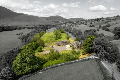
Hill Top offers a rare opportunity to acquire a former stock rearing farm situated within the village of Shap. The range of traditional and modern buildings offer spacious livestock accommodation along with the exciting potential for conversion and development (Subject to the relevant consents).
The land in total extends to 15.12 acres (6.12 hectares) and is highly suitable for grazing and mowing purposes.
At the front of the property there is a traditionally constructed, stone-built farmhouse with a slate roof. The farmhouse is in need of some modernisation and refurbishment therefore offering an exciting project for a prospective purchaser. The 3-bedroom property benefits from uPVC double glazing.
The property is to be offered for sale as lots or as a Whole by Private Treaty. The Seller reserves the right to amalgamate, withdraw, or exclude any of the property shown at any time or to generally amend the particulars or order of sale.
GUIDE PRICE AS A WHOLE: £375,000
(THREE HUNDRED AND SEVENTY FIVE THOUSAND POUNDS)
GUIDE PRICE LOT 1:
£250,000 (Two Hundred and Fifty Thousand Pounds).
Comprising of the farmhouse and range of traditional and semi modern Farm buildings extending to 0.73 acre (edged Red).
GUIDE PRICE LOT 2:
£15,000 (Fifteen Thousand Pounds).
Land adjacent to the steading extending to 1.27 acres (edged Blue).
GUIDE PRICE LOT 3:
£85,000 (Eighty Five Thousand Pounds).
Agricultural Land extending to 10.48 acres with a traditional Hogg House (edged pink)
GUIDE PRICE LOT 4:
£25,000 (Twenty Five Thousand Pounds).
Land on the edge of A6 extending to 2.64 acres (edged Green)
THE LAND
Hill Top Farm extends in total to 15.12 acres (6.12 hectares) of Grade 4 agricultural land, available as a whole or four lots.
SERVICES
The boundaries comprise dry stone walls.
Lot 1 is serviced by a mains water supply.
Lot 2 is serviced by a mains water supply but please note if Lot 1 and Lot 2 are sold individually the purchaser of Lot 2 will be required to install a meter to split the water supply from Lot 1.
Lot 3 is serviced by a natural water supply.
Lot 4 is serviced a mains water supply.
BUILDINGS
1 – Farmhouse
2 – Stone barn: 2 story, traditional stone barn with slate roof and timber beams. Adjoining house.
3 – Log store/ general storage: Part concrete block and part brick construction with wooden cladding and tin sheet roof.
4 – Machinery shed: Block construction with timber beams and tin sheet cladding and roof.
5 – General Purpose Building : 4x bay, steel portal frame, concrete panel walls, tin sheet cladding and roof.
6 – Crop Store: Steel portal frame, block walls and cement fibre roof.
7 – Loose housing shed: 4-bay, steel portal frame, concrete panel walls, Yorkshire board cladding and cement fibre/tin sheet roof.
8 – Sheep housing shed: 4-bay steel portal frame shed with concrete floor, concrete/ block walls and sheeted roof.
NITRATE VULNERABLE ZONE
The land is not within a Nitrate Vulnerable Zone.
ENVIRONMENTAL SCHEMES
The land is not currently entered into any environmental schemes.
TENURE
The property is offered for sale Freehold with Vacant Possession on completion.
SPORTING & MINERAL RIGHTS
The sporting and mineral rights are for sale insofar as they are owned.
BURDENS
The property is sold subject to all rights including rights of way, whether public or private, rights of light, support, drainage, water and electricity supplies and other rights, obligations and easements, quasi easements and restrictive covenants and all existing and proposed wayleaves for masts, pylons, stays, cables, drains and water, gas and other pipes, whether or not constituted in the title deeds or referred to in these particulars.
VIEWINGS
Viewings are strictly by appointment, please contact us on .
METHOD OF SALE
OFFERS ARE TO BE SUBMITTED, ALONG WITH PROOF OF FUNDING, NO LATER THAN 12 NOON FRIDAY 3rd JULY 2026
The property is to be offered for sale as lots or as a Whole by Private Treaty. The Seller reserves the right to amalgamate, withdraw, or exclude any of the property shown at any time or to generally amend the particulars or order of sale.
AGENT DETAILS
Alice Fawcett – Alice. –
SOLICITORS DETAILS
Bethan Griffiths, Cartmell Shepherd, Bishop Yards, Penrith, Cumbria, CA11 7XU
IMPORTANT NOTICE
H&H LAND & ESTATES Ltd for themselves and for the Vendor or Lessors of this property, whose Agents they are, give notice that:
(i) the particulars are set out as a general outline only for the guidance of intending Purchasers or Lessees and do not constitute, nor constitute part of, an offer or contract;
(ii) all descriptions, dimensions, areas references to condition and necessary permissions for use and occupation and other detail are given as a guide only and without responsibility and any intending Purchasers or Tenants should not rely on them as statements or representations of fact but must satisfy themselves, by inspection or otherwise, as to the correctness of each of them; no employee of H&H LAND & ESTATES Ltd has the authority to make or give any representation or warranty whatever in relation to this property nor is any such representation or warranty given whether by H&H LAND & ESTATES Ltd. or the Vendors or the Lessors of this property.
(iii) The making of any offer (bid) for this property will be taken as an admission by the intending Purchaser that s/he has relied solely upon his own personally verified information, inspection and enquiries.
(iv) The photographs depict only certain parts of the property. It should not be assumed that the property remains as displayed in the photographs.
(v) Where any reference is made to planning permissions or potential uses, such information is given by H&H LAND & ESTATES Ltd in good faith. Prospective Purchasers should make their own enquiries with the Local Planning Authority into such matters.
(vi) The Vendors reserve the right to amalgamate, withdraw or exclude either of the Lots shown at any time and to generally amend the particulars or method of sale.
(vii) The property is sold subject to reserve(s).
(viii) H&H LAND & ESTATES Ltd reserve the right to sell privately without imposing a closing date and do not bind themselves to accept the highest or any offer.
These particulars have been prepared in accordance with The Business Protection from Misleading Marketing Regulations to give a fair overall view of the property
Directions
Tebay 9 Miles ~ Appleby-in-Westmorland 11 Miles ~ Penrith 11 Miles
what3words smarter.treatable.ages
Viewing is strictly by appointment with our Carlisle office.
Services
The property is serviced by mains electricity and water. The property does not benefit from central heating.
Drainage for the farmhouse is to a private septic tank. Please note no formal investigation has been carried out as to the operation of the sewerage system and septic tank, these may not meet the current General Binding Rules 2020 and the property is being sold on this basis. All parties must ensure that their lenders are aware of this before submitting an offer.
COUNCIL TAX
TBA
KEY INFORMATION
• Standard construction.
• We understand that broadband and mobile telephone reception are available. For an indication of speeds and supply please see the OFCOM website:
• There is private off road vehicle parking
Map Location
Property details
- Tenure
- Freehold
- Council Tax Band
- C
- Date Posted
- 2026-05-23
Market Value Analysis
Compared with 60 Farms & Smallholdings listings in North West England (10+ acres).
Energy Performance Certificate
Energy Efficiency Rating
Based on UK Energy Performance Certificate standards (EU Directive 2002/91/EC)
Running costs are one side. Planning activity, flood history and ground risks for this location are in the full report.
Utilities & Restrictions
Utilities
- Electricity
- Ask Agent
- Water
- Ask Agent
- Heating
- Ask Agent
- Broadband
- Ask Agent
- Sewerage
- Ask Agent
Rights & Restrictions
- Public Rights of Way
- Ask Agent
- Private Rights of Way
- Ask Agent
- Listed Property
- Ask Agent
- Restrictions
- Ask Agent
Listed status, conservation areas and planning constraints for this location are in the full report.
Property Features
- Accessibility
- Ask Agent
- Parking
- Parking Available
- Garden
- Garden
Beyond the particulars: planning activity, flood history, heritage and ground risks, checked for this exact spot.
Connectivity
Broadband
Fastest speed available at this postcode
1.8 Gbps
Gigabit full fibre
Suitable for
- 4K streaming on every screen
- Full-time home working
- Online gaming & big downloads
Mobile signal
Predicted 4G and 5G signal; indoor signal depends on building materials.
Ofcom Connected Nations postcode-level predictions. Speeds and signal are modelled, not measured, and vary between addresses and providers.
Signal is the easy part. Planning activity, flood history and protected designations here are in the full report.
Nearest Schools
Primary
- Shap Endowed CofE Primary School355 metresNo Ofsted rating
- Ages
- 3 to 11
- Pupils
- 88
- Type
- Voluntary aided school
- Faith
- Church of England
- Crosby Ravensworth CofE School3.7 milesOfsted: Good *
- Ages
- 3 to 11
- Pupils
- 42
- Type
- Voluntary aided school
- Faith
- Church of England
- Morland Area CofE Primary School4.7 milesOfsted: Good *
- Ages
- 2 to 11
- Pupils
- 119
- Type
- Voluntary aided school
- Faith
- Church of England
- Lowther Endowed School5.1 milesNo Ofsted rating
- Ages
- 5 to 11
- Pupils
- 34
- Type
- Voluntary aided school
- Orton CofE School6 milesNo Ofsted rating
- Ages
- 3 to 11
- Pupils
- 47
- Type
- Voluntary aided school
- Faith
- Church of England
Secondary
- Appleby Grammar School8.1 milesOfsted report card · May 2026
- Ages
- 11 to 18
- Pupils
- 357
- Type
- Academy converter
- Ullswater Community College9.2 milesOfsted: Good
- Ages
- 11 to 18
- Pupils
- 1,520
- Type
- Foundation school
- Queen Elizabeth Grammar School Penrith9.3 milesOfsted: Good
- Ages
- 11 to 18
- Pupils
- 1,026
- Type
- Academy converter
- The Queen Katherine School14 milesOfsted report card · May 2026
- Ages
- 11 to 19
- Pupils
- 910
- Type
- Academy converter
- Kirkby Stephen Grammar School14 milesOfsted: Good
- Ages
- 11 to 18
- Pupils
- 377
- Type
- Academy converter
* Latest graded judgement covers quality of education only; no overall grade was issued under the 2024-25 inspection framework.
Distances are straight-line from the advertised location. Source: the national school registers (DfE, Welsh Government, Scottish Government) and Ofsted.
Schools are just the start: sold prices nearby, planning activity and any flood history are in the full report.
Amenities
Supermarket
GP surgery
Pharmacy
Hospital
Green space
Walking trail
Straight-line distances from the advertised location. Sources: NHS records, Geolytix supermarket locations, OS Open Greenspace and the national trails registers.
The area stacks up? Now check the location itself: planning nearby, protected designations and past flooding.
Getting Around
Nearest station
Nearest bus stop
Typical drive times
Straight-line distances from the advertised location; drive times are typical free-flow times over OpenStreetMap road data, so allow more at peak. Public transport locations from DfT NaPTAN.
Easy to reach matters. So do planning activity, flood history and ground risks: all in the full report.
Flood Risk
Environment Agency open data, checked around the advertised map pin for the listed acreage. Long-term risk counts flood defences; the planning map's flood zones do not. The map pin for this listing marks the postcode area rather than the exact location, so these readings describe the surrounding area. Provided by LandSale, not the listing agent, and not part of the agent's particulars. Risk varies across a holding, so verify before committing.
Rivers and the sea
Planning map: Flood Zone 3, about 50 metres away.
Surface water
Not at the pin: mapped about 50 metres away.
These bandings are the summary. Where this location sits on the flood maps, plus planning activity, heritage and ground risks, is in the full report.
Important notice: Information, maps and tags on this page are drawn from the advertising agent's marketing materials or generated automatically. LandSale has not verified them. Relying on these details is at your own risk, always carry out independent checks before committing to a purchase.
LandSale full disclaimer
Marketing information only - not formal particulars. The details on this website are provided for general guidance and do not constitute an offer or contract. Neither LandSale nor the advertising estate/land agent accepts responsibility for any inaccuracy.
1. Source of information
- Listing content: Core description, asking price, tenure, measurements, photographs and planning history originate from the marketing materials of the advertising estate or land agent. LandSale does not author this content and cannot guarantee its accuracy.
- Automated tags & categorisation: Property type, land-use class, acreage bands and similar labels may be applied by machine-learning models. They are intended as a helpful guide only and may not reflect the property's legal status or permitted use.
- Third-party & enriched data layers: Maps, boundary outlines, planning designations, soil reports, broadband coverage and other environmental or location-based insights are licensed from external suppliers. Such data are supplied “as is", may be incomplete or out of date and are subject to change without notice.
2. Verification required
Prospective purchasers must verify critical matters, including but not limited to planning permission, title boundaries, public rights of way, environmental constraints, acreage, services, access and VAT status, through their own inspections, specialist surveys, legal advisers and the selling agent before relying on the information or entering into any contract.
3. No warranty or liability
LandSale gives no warranty, express or implied, as to the accuracy, completeness or fitness for any particular purpose of the information displayed. LandSale shall not be liable for any loss, damage, cost or expense arising directly or indirectly from any use of or reliance on such information, save where liability may not be excluded by law.
4. Updates & feedback
If you believe any detail on this listing is inaccurate, please let us know. We will investigate and, where appropriate, update the listing or notify the agent.
© LandSale | Version 1.3 - August 2026
Listing agent
H&H Land & Estates, Carlisle
Borderway Mart, Rosehill, Carlisle, Cumbria, CA1 2RS
View agent profileSimilar properties for sale
- Price
- Guide Price£375,000
- Size
- 4.9 acres
Cautley, Sedbergh, Cumbria, Sedbergh, Westmorland and Furness LA10 England
Added on 08/10/2026Smallholding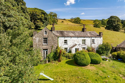
- Price
- Guide Price£500,000
- Size
- 100.55 acres
Gap and Hewthwaite Farm, Dent, Sedbergh, Cumbria, Dent, Westmorland and Furness LA10 England
Added on 02/10/2026Farm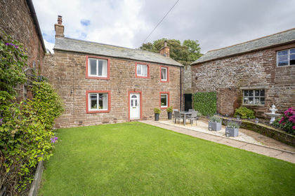
- Price
- Offers in Excess of£350,000
Added on 01/10/2026Farmhouse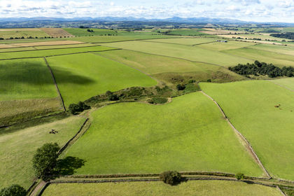
- Price
- Offers in Excess of£300,000
- Size
- 51.52 acres
Added on 01/10/2026Agricultural Land
- Price
- Offers in Excess of£230,000
- Size
- 38.79 acres
Added on 01/10/2026Small Farm
- Price
- Offers in Excess of£325,000
- Size
- 3.21 acres
Added on 01/10/2026Small Farm
- Price
- Offers in Excess of£280,000
- Size
- 47.54 acres
PARK HEAD FARM, WELTON, CARLISLE, CA5 7HL - LOT 2, Sebergham, Cumberland CA5 England
Added on 17/07/2026Farm
- Price
- Guide Price£465,000
- Size
- 42.27 acres
Added on 17/07/2026Agricultural Land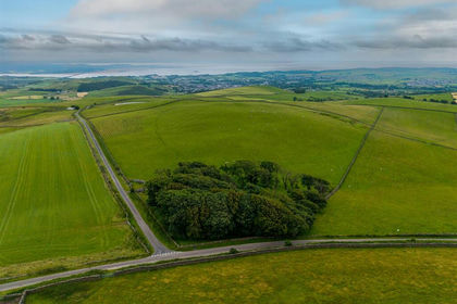
- Price
- £240,000
- Size
- 28.87 acres
Added on 20/07/2026Small Farm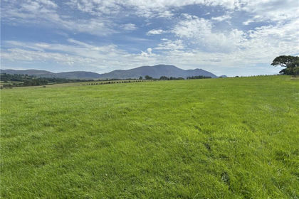
- Price
- £450,000
- Size
- 45.88 acres
Lot 6 - Prospect Farm, Cockermouth, Cumbria, CA13, Setmurthy, Cumberland CA13 England
Added on 18/08/2026Farmland