Land At The Harvester PH, Harrington Road, Stockwood, Bristol, BS14 8JZ
- Land size
- 0.07 acres
Key Features
- Potential residential development opportunity (STP) located adjacent to the Harvester pub in Stockwood
- Alternate use for additional parking for nearby businesses or dwellings
- The land abuts the Burnbush Park at the rear
- Site area of c. 0.073 acres
- Freehold unconditional offers invited
- Likely to be of interest to local/regional developers, builders and investors
Description
Location
Stockwood is a large suburban district to the south of Bristol, characterised by established residential neighbourhoods, local shopping parades, schools and community amenities. The area benefits from strong connectivity into Bristol city centre via the A37 and A4 corridors, as well as convenient access to the wider region through the A4174 Ring Road. The locality is well-served by public transport and sits within easy reach of Keynsham, Whitchurch and the wider South Bristol catchment.
The land is adjacent to the Harvester PH and occupies a prominent roadside position on Harrington Road, forming part of a well-established commercial cluster serving the surrounding residential population. The site benefits from strong visibility, generous frontage and convenient access to Burnbush Park at the rear.
Property Description
The parcel of land comprises a large tarmacked car park and is c. 0.073 acres in size.
Tenure Comments
Freehold. The site forms part of the pub's title (AV240624) and will be separated at the point of sale. The demise of the site is shown for guidance purposes on page 1&3 and outlined in blue.
Planning and Development
We have been advised that the site is not located within a flood zone, and the adjoining properties are not listed, nor does the site fall within a conservation area. However, all interested parties must rely on their own enquiries to verify this information.
Bristol City Council -
Highways
Direct access is obtained from Harrington Road, with an existing entrance already in place. Prospective purchasers should undertake their own investigations to ensure the access arrangements are suitable for any proposed development.
Services
It is understood that all the main services are available in the adjacent highways but prospective purchasers should undertake their own investigations with the relevant utility companies to ensure all services are available and adequate for the proposed development.
VAT
VAT is applicable on the sale of the land.
Viewings
All viewings are strictly by appointment only.
Map Location
Property details
- Tenure
- Freehold
- Council Tax Band
- Ask Agent
- Date Posted
- 2026-05-19
Utilities & Restrictions
Utilities
- Electricity
- Ask Agent
- Water
- Ask Agent
- Heating
- Ask Agent
- Broadband
- Ask Agent
- Sewerage
- Ask Agent
Rights & Restrictions
- Public Rights of Way
- Ask Agent
- Private Rights of Way
- Ask Agent
- Listed Property
- Ask Agent
- Restrictions
- Ask Agent
Property Features
- Accessibility
- Ask Agent
- Parking
- Parking Available
- Garden
- Ask Agent
Important notice: Information, maps and tags on this page are supplied by the advertising agent or generated automatically. LandSale has not verified them. Relying on these details is at your own risk, always carry out independent checks before committing to a purchase.
LandSale full disclaimer
Marketing information only - not formal particulars. The details on this website are provided for general guidance and do not constitute an offer or contract. Neither LandSale nor the advertising estate/land agent accepts responsibility for any inaccuracy.
1. Source of information
- Agent-supplied content: Core description, asking price, tenure, measurements, photographs and planning history are uploaded by the appointed agent, who remains solely responsible for their accuracy.
- Automated tags & categorisation: Property type, land-use class, acreage bands and similar labels may be applied by machine-learning models. They are intended as a helpful guide only and may not reflect the property's legal status or permitted use.
- Third-party & enriched data layers: Maps, boundary outlines, planning designations, soil reports, broadband coverage and other environmental or location-based insights are licensed from external suppliers. Such data are supplied “as is", may be incomplete or out of date and are subject to change without notice.
2. Verification required
Prospective purchasers must verify critical matters, including but not limited to planning permission, title boundaries, public rights of way, environmental constraints, acreage, services, access and VAT status, through their own inspections, specialist surveys, legal advisers and the selling agent before relying on the information or entering into any contract.
3. No warranty or liability
LandSale gives no warranty, express or implied, as to the accuracy, completeness or fitness for any particular purpose of the information displayed. LandSale shall not be liable for any loss, damage, cost or expense arising directly or indirectly from any use of or reliance on such information, save where liability may not be excluded by law.
4. Updates & feedback
If you believe any detail on this listing is inaccurate, please let us know. We will investigate and, where appropriate, update the listing or notify the agent.
© LandSale | Version 1.2 - January 2026
Listing agent
WTS Property Consultants, Birmingham
6 Bennetts Hill, Birmingham, B2 5ST
Similar properties for sale
- Price
- £65,000
- Size
- 4.74 acres
Added on 22/06/2026Pasture
- Price
- Guide Price£55,000
Added on 23/05/2026Building Plot
- Price
- Guide Price£65,000
- Size
- 0.18 acres
Plot | Planning Granted | Alveston, Alveston, South Gloucestershire BS35 3LZ England
Added on 05/06/2026Building Plot
- Price
- Offers in Region of£100,000
Nupdown Lane, Nupdown, BS35, Hill, South Gloucestershire BS35 1RS England
Added on 18/06/2026Agricultural Land
- Price
- Guide Price£100,000
- Size
- 4.45 acres
Land at Woodcroft, Chepstow, Tidenham, Gloucestershire NP16 7PU England
Added on 15/06/2026Farmland
- Price
- Offers Over£40,000
- Size
- 6.2 acres
LOT 2, Harp Road, TA9, Brent Knoll, Somerset TA9 4HH England
Added on 17/07/2026Development Land
- Price
- Offers Over£40,000
- Size
- 6.2 acres
Lot 2, Harp Road, TA9, Brent Knoll, Somerset TA9 4HH England
Added on 17/07/2026Development Land
- Price
- Offers in Region of£65,000
- Size
- 0.25 acres
Land - High Field Road, Cross Hands, Lydney, Lydney, Gloucestershire GL15 5NS England
Added on 25/05/2026Undeveloped Land
- Price
- Guide Price£75,000
Harold Road, Yorkley, GL15, West Dean, Gloucestershire GL15 4SR England
Added on 25/05/2026Building Plot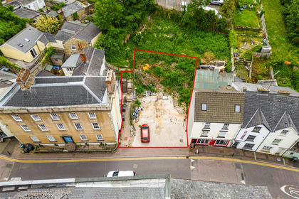
- Price
- Guide Price£75,000
- Size
- 0.08 acres
Site | Planning | Coleford, Coleford, Gloucestershire GL16 8AH England
Added on 05/06/2026Development Land