Llanddeusant, Holyhead, Sir Ynys Mon, LL65
- Bedrooms
- 3
- Bathrooms
- 2
Key Features
- Detached countryside barn conversion
- Far-reaching rural views
- Self-contained one bedroom annexe
- Planning permission for two semidetached dwellings (material start made)
- Derelict stone outbuilding offering further potential (subject to consent)
- Character features including woodburning stove and vaulted spaces
- Generous gardens and private parking
- Peaceful rural setting within the Anglesey countryside
Description
An exceptional countryside barn conversion offering character, space and flexibility, set against sweeping open rural views and enhanced by a self-contained annexe and significant development potential.
Nestled within a charming cluster of historic farm buildings in the heart of the Anglesey countryside, this beautifully presented detached barn conversion combines rural lifestyle appeal with exciting future opportunities. In addition to the main residence, the property includes a one bedroom annexe and a derelict semidetached stone outbuilding, together with planning permission for a pair of semidetached dwellings, with a material start already underway.
Enjoying open countryside views, private parking and generous garden areas, the property will appeal to buyers seeking space, versatility and long-term potential in a peaceful rural setting.
The main house is entered via a spacious and welcoming entrance hall, featuring an attractive split staircase rising to a galleried landing and study area. An understairs cupboard provides useful storage, with doors leading into the principal living accommodation.
The lounge is a comfortable and inviting reception room with windows to the front and side elevations and a woodburning stove set on a tiled hearth, creating a warm focal point. Double doors lead into the conservatory, which enjoys views across the gardens and surrounding countryside and provides access to the rear garden, making it an ideal space for relaxation or entertaining.
The kitchen/dining room is fitted with a range of base and wall units with worktop space over, a one and a half bowl sink with mixer tap and space for an oven. A rear facing window provides good natural light to the dining area.
A ground floor bathroom is accessed from the entrance hall and is fitted with a three-piece suite comprising a bath with electric shower over, wash hand basin and heated towel rail. An airing cupboard houses plumbing for a washing machine.
To the first floor, the galleried landing is illuminated by a skylight and provides access to two bedrooms, both offering characterful eaves accommodation with restricted head height. Bedroom one benefits from built-in wardrobes, a side facing window and two skylights, while bedroom two offers eaves storage, a side facing window and two skylights.
Located opposite the main dwelling, the detached annexe offers valuable additional accommodation, suitable for use as part of the main residence but not for independent occupation or rental. The annexe comprises an entrance hall leading to an open plan L-Shaped kitchen and living area with windows to the front and side elevations and two skylights. The kitchen is fitted with matching base and wall units, a Belfast sink, integrated fridge and space for a cooker. There is also a double bedroom with side facing windows and a skylight, along with a shower room fitted with a corner shower, wash hand basin, low-level WC and plumbing for a washing machine.
Externally, the property continues to impress with attractive garden areas designed to take full advantage of the far-reaching countryside views, creating a private and tranquil space ideal for outdoor living. A private parking area adds convenience, while the derelict semidetached stone outbuilding presents further scope for development, subject to the necessary consents.
A major highlight of the property is the planning permission for two semidetached dwellings, with a material start already made, offering an exciting opportunity for development or future investment within this desirable rural location.
The property is served by a private water supply and shares an effluent treatment plant with a neighbouring property.
To summarise, this distinctive countryside property offers a rare combination of characterful accommodation, flexible living space and genuine future potential. With a well-presented barn conversion, a versatile annex, generous gardens and far-reaching rural views, it provides an enviable lifestyle opportunity in a peaceful Anglesey setting. The added benefit of existing planning permission further enhances its appeal, making this an excellent choice for those seeking a home with scope for growth, investment or multigenerational living
Llanddeusant is a small and peaceful rural village set within the heart of the Anglesey countryside, offering an ideal balance of tranquillity and accessibility. Surrounded by open farmland and rolling countryside, the area is renowned for its unspoilt landscape, sense of space and traditional Welsh charm, making it particularly appealing to those seeking a quieter pace of life without feeling isolated.
Despite its rural setting, Llanddeusant is well placed for access to the wider island. Nearby villages and market towns provide everyday amenities, while larger centres such as Holyhead and Llangefni offer a wider range of shops, schools, supermarkets and services. The A55 is easily accessible, providing direct links to the mainland and onwards to Chester and the North West, making the location practical for commuters and those who travel regularly.
Anglesey is celebrated for its stunning coastline, and Llanddeusant sits within easy reach of some of the island’s most popular beaches and coastal destinations, including Trearddur Bay, Rhosneigr and Newborough Forest, which is famed for its woodland walks and views across to Snowdonia. The surrounding area also offers excellent opportunities for walking, cycling and outdoor pursuits, with scenic country lanes and footpaths right on the doorstep.
Well known for its strong community spirit, natural beauty and lifestyle appeal, Llanddeusant and its surrounding areas offer an inviting setting for those looking to enjoy countryside living while remaining connected to everything Anglesey has to offer.
Map Location
Property details
- Tenure
- Freehold
- Council Tax Band
- D
- Date Posted
- 2026-04-29
Energy Performance Certificate
Energy Efficiency Rating
Based on UK Energy Performance Certificate standards (EU Directive 2002/91/EC)
Running costs are one side. Planning activity, flood history and ground risks for this location are in the full report.
Utilities & Restrictions
Utilities
- Electricity
- Mains
- Water
- Private Supply
- Heating
- Electric Heating, Wood Burner
- Broadband
- Ask Agent
- Sewerage
- Septic Tank / Private
Rights & Restrictions
- Public Rights of Way
- Ask Agent
- Private Rights of Way
- Ask Agent
- Listed Property
- Ask Agent
- Restrictions
- Ask Agent
Listed status, conservation areas and planning constraints for this location are in the full report.
Property Features
- Accessibility
- Ask Agent
- Parking
- Driveway, Off-Street Parking
- Garden
- Garden
Beyond the particulars: planning activity, flood history, heritage and ground risks, checked for this exact spot.
Connectivity
Broadband
Fastest speed available at this postcode
12 Mbps
Standard (10-30 Mbps)
Suitable for
- Web & social
- Music streaming
- Standard video calls
Mobile signal
Outdoor predictions; indoor signal depends on building materials.
Ofcom Connected Nations postcode-level predictions. Speeds and signal are modelled, not measured, and vary between addresses and providers.
Signal is the easy part. Planning activity, flood history and protected designations here are in the full report.
Nearest Schools
Primary
- Rhyd y Llan2.2 miles
- Pupils
- 118
- Type
- Nursery, Infants & Juniors
- Language
- Welsh medium school / provision (including transitional)
- Ysgol Gymuned Llanfechell2.4 miles
- Pupils
- 81
- Type
- Nursery, Infants & Juniors
- Language
- Welsh medium school / provision (including transitional)
- Ysgol Cemaes3.6 miles
- Pupils
- 63
- Type
- Nursery, Infants & Juniors
- Language
- Welsh medium school / provision (including transitional)
- Ysgol Gynradd Bodedern4.5 miles
- Pupils
- 85
- Type
- Nursery, Infants & Juniors
- Language
- Welsh medium school / provision (including transitional)
- Ysgol Gymuned Llannerch-y-medd4.8 miles
- Pupils
- 123
- Type
- Nursery, Infants & Juniors
- Language
- Welsh medium school / provision (including transitional)
Secondary
- Ysgol Uwchradd Bodedern4.7 miles
- Pupils
- 810
- Type
- Secondary (ages 11-19)
- Language
- Welsh medium school / provision (including transitional)
- Ysgol Syr Thomas Jones6.2 miles
- Pupils
- 537
- Type
- Secondary (ages 11-19)
- Language
- Welsh medium school / provision (including transitional)
- Ysgol Uwchradd Caergybi7.3 miles
- Pupils
- 818
- Type
- Secondary (ages 11-19)
- Language
- Welsh medium school / provision (including transitional)
- Ysgol Gyfun Llangefni9.7 miles
- Pupils
- 761
- Type
- Secondary (ages 11-19)
- Language
- Welsh medium school / provision (including transitional)
- Ysgol David Hughes16 miles
- Pupils
- 1,123
- Type
- Secondary (ages 11-19)
- Language
- Welsh medium school / provision (including transitional)
Distances are straight-line from the advertised location. Source: the national school registers (DfE, Welsh Government, Scottish Government) and Ofsted.
Schools are just the start: sold prices nearby, planning activity and any flood history are in the full report.
Amenities
Supermarket
GP surgery
Pharmacy
Straight-line distances from the advertised location. Sources: NHS records, Geolytix supermarket locations, OS Open Greenspace and the national trails registers.
The area stacks up? Now check the location itself: planning nearby, protected designations and past flooding.
Getting Around
Nearest station
Nearest bus stop
Typical drive times
Straight-line distances from the advertised location; drive times are typical free-flow times over OpenStreetMap road data, so allow more at peak. Public transport locations from DfT NaPTAN.
Easy to reach matters. So do planning activity, flood history and ground risks: all in the full report.
Flood Risk
From Natural Resources Wales flood map open data, checked around the advertised map pin and allowing for the listed acreage where known. This summary comes from LandSale, the advertising platform, not from the listing agent, and is not part of the agent's particulars. Risk can vary across a single holding, so verify anything critical through your own searches before committing.
Rivers and the sea
Surface water
The detail behind these bandings
The full report pinpoints where this location sits on the flood maps, and runs the deeper checks that usually only surface after an offer.
- Exact flood zones & annual chances (included in the full report)
- Any recorded past flooding (included in the full report)
- Planning activity nearby (included in the full report)
- Heritage & conservation (included in the full report)
- Protected nature designations (included in the full report)
- Ground risks (included in the full report)
- Sold prices nearby (included in the full report)
£14.99 · one-off purchase
By LandSale, the platform. Not provided by the listing agent. Ready in about a minute.
Important notice: Information, maps and tags on this page are drawn from the advertising agent's marketing materials or generated automatically. LandSale has not verified them. Relying on these details is at your own risk, always carry out independent checks before committing to a purchase.
LandSale full disclaimer
Marketing information only - not formal particulars. The details on this website are provided for general guidance and do not constitute an offer or contract. Neither LandSale nor the advertising estate/land agent accepts responsibility for any inaccuracy.
1. Source of information
- Listing content: Core description, asking price, tenure, measurements, photographs and planning history originate from the marketing materials of the advertising estate or land agent. LandSale does not author this content and cannot guarantee its accuracy.
- Automated tags & categorisation: Property type, land-use class, acreage bands and similar labels may be applied by machine-learning models. They are intended as a helpful guide only and may not reflect the property's legal status or permitted use.
- Third-party & enriched data layers: Maps, boundary outlines, planning designations, soil reports, broadband coverage and other environmental or location-based insights are licensed from external suppliers. Such data are supplied “as is", may be incomplete or out of date and are subject to change without notice.
2. Verification required
Prospective purchasers must verify critical matters, including but not limited to planning permission, title boundaries, public rights of way, environmental constraints, acreage, services, access and VAT status, through their own inspections, specialist surveys, legal advisers and the selling agent before relying on the information or entering into any contract.
3. No warranty or liability
LandSale gives no warranty, express or implied, as to the accuracy, completeness or fitness for any particular purpose of the information displayed. LandSale shall not be liable for any loss, damage, cost or expense arising directly or indirectly from any use of or reliance on such information, save where liability may not be excluded by law.
4. Updates & feedback
If you believe any detail on this listing is inaccurate, please let us know. We will investigate and, where appropriate, update the listing or notify the agent.
© LandSale | Version 1.3 - August 2026
Similar properties for sale
 Added on 15/03/2026Barn Conversion
- Price
- £385,000
- Size
- 1 acres
Added on 29/01/2026Cottage
- Price
- Guide Price£360,000
- Size
- 20.48 acres
Added on 06/06/2026Smallholding
- Price
- £370,000
- Size
- 2.8 acres
B5110, Brynteg, Anglesey, LL78, Llanfair-Mathafarn-Eithaf, Isle of Anglesey LL78 Wales
Added on 29/01/2026Cottage
- Price
- £325,000
- Size
- 1.46 acres
Penrallt, Llangefni, Isle of Anglesey, LL77, Llangefni, Isle of Anglesey LL77 Wales
Added on 26/06/2026Redevelopment Land
- Price
- Offers in Region of£269,000
Added on 24/06/2026Residential
- Price
- Offers in Region of£420,000
- Size
- 3.97 acres
Pen Cob, Malltraeth, Anglesey, LL62, Bodorgan, Isle of Anglesey LL62 Wales
Added on 08/08/2026House with Land
- Price
- £410,000
- Size
- 1 acres
Newborough, Isle Of Anglesey, Sir Ynys Mon, LL61, Rhosyr, Isle of Anglesey LL61 Wales
Added on 14/08/2026House with Land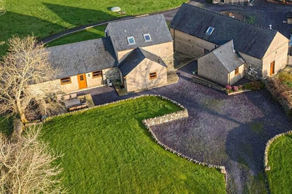
- Price
- £365,000
Added on 17/06/2026Barn Conversion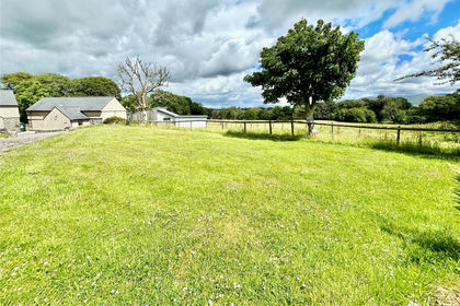
- Price
- £365,000
Added on 17/06/2026Barn Conversion