Ffair Rhos, Ystrad Meurig, SY25
Key Features
- Parcel of land on the footsteps of the Cambrian Mountains
- Gently sloping pastures with capabilities of good grazing
- Small woodland area
- Mixed use land with good grazing and hay fields with part rough grazing
- valuable add-on usefully sized block to any agricultural enterprise
- 0.5 of a mile from the B4343
- 2.2 miles from the village of Pontrhydfendigaid
Description
*** A rare opportunity of acquiring a large parcel of land on the footsteps of the Cambrian Mountains *** *** Boundary fenced with a number of good sized enclosures *** Mixed use land with good grazing and hay fields with part rough grazing - Gently sloping pastures with capabilities of good grazing *** Small woodland area *** Easy access via a council maintained highway ***
*** A valuable add-on usefully sized block to any agricultural enterprise *** Alternatively, the land would suit smallholders seeking to expand, conservation or other alternative uses ***
*** 0.5 of a mile from the B4343 *** 2.2 miles from the village of Pontrhydfendigaid *** 8 miles from Tregaron *** 16 miles from the university town of Aberystwyth *** A dream move to create your very own farm ***
*** Contact us today to view ***
Location
The land is located in Mid Ceredigion. 16 miles South East of the University town, coastal resort and administrative center of Aberywstyth and 8 miles North from the market town of Tregaron. The land is accessed via a council maintained single track highway which provides easy access for all kind of vehicles or machinery. The land and its location is unspoilt while overlooking untouched Welsh countryside
General Description
This is a great opportunity to either add on or to begin a new venture. This land offers a wide range of opportunities and will accommodate all types of livestock.
The land is set in one large block. Approx 90 acres of the land being hill type grazing as one block all within a stock proof ring fence. A no through quiet council maintained road runs through the middle of the land with cattle grids on the boundaries of the land. The land is all easily accessible.
The remaining 10 acres or thereabouts to the West of the homestead is of gently sloping permanent pasture. Spilt into easily maintained paddocks being stock proof fenced and benefiting from natural free drainage. Easy access for agricultural machinery to all paddocks from the council maintained no through road. The property extends to approximately 103 acres or thereabouts.
Land
Tenure and Possession
We are informed the land is of Freehold Tenure and will be vacant on completion.
Money Laundering Regulations
The successful Purchaser wil be required to produce adequate identification to prove their identity within the terms of the Money Laundering Regulations. Appropriate examples include Passport/Photo Driving License and a recent Utility Bill. Proof of funds will also be required or mortgage in principle papers if a mortgage is required.
What3words
what3words will point you to where the properties lies on the map - value.moved.remission
Map Location
Property details
- Tenure
- Freehold
- Council Tax Band
- Ask Agent
- Date Posted
- 2026-04-22
Utilities & Restrictions
Utilities
- Electricity
- Ask Agent
- Water
- Ask Agent
- Heating
- Ask Agent
- Broadband
- Ask Agent
- Sewerage
- Ask Agent
Rights & Restrictions
- Public Rights of Way
- Ask Agent
- Private Rights of Way
- Ask Agent
- Listed Property
- Ask Agent
- Restrictions
- Ask Agent
Property Features
- Accessibility
- Ask Agent
- Parking
- Ask Agent
- Garden
- Garden
Important notice: Information, maps and tags on this page are supplied by the advertising agent or generated automatically. LandSale has not verified them. Relying on these details is at your own risk, always carry out independent checks before committing to a purchase.
LandSale full disclaimer
Marketing information only - not formal particulars. The details on this website are provided for general guidance and do not constitute an offer or contract. Neither LandSale nor the advertising estate/land agent accepts responsibility for any inaccuracy.
1. Source of information
- Agent-supplied content: Core description, asking price, tenure, measurements, photographs and planning history are uploaded by the appointed agent, who remains solely responsible for their accuracy.
- Automated tags & categorisation: Property type, land-use class, acreage bands and similar labels may be applied by machine-learning models. They are intended as a helpful guide only and may not reflect the property's legal status or permitted use.
- Third-party & enriched data layers: Maps, boundary outlines, planning designations, soil reports, broadband coverage and other environmental or location-based insights are licensed from external suppliers. Such data are supplied “as is", may be incomplete or out of date and are subject to change without notice.
2. Verification required
Prospective purchasers must verify critical matters, including but not limited to planning permission, title boundaries, public rights of way, environmental constraints, acreage, services, access and VAT status, through their own inspections, specialist surveys, legal advisers and the selling agent before relying on the information or entering into any contract.
3. No warranty or liability
LandSale gives no warranty, express or implied, as to the accuracy, completeness or fitness for any particular purpose of the information displayed. LandSale shall not be liable for any loss, damage, cost or expense arising directly or indirectly from any use of or reliance on such information, save where liability may not be excluded by law.
4. Updates & feedback
If you believe any detail on this listing is inaccurate, please let us know. We will investigate and, where appropriate, update the listing or notify the agent.
© LandSale | Version 1.2 - January 2026
Listing agent
Morgan & Davies, Lampeter
12 Harford Square, Lampeter, SA48 7DT
Similar properties for sale

- Price
- Guide Price£600,000
- Size
- 227 acres
Rhandirmwyn, Llandovery, Llanfair-ar-y-bryn, Carmarthenshire SA20 0PB Wales
Added on 29/01/2026Mountain Land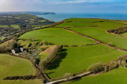
- Price
- £500,000
- Size
- 59.6 acres
Land at Morfa Uchaf, Llangrannog, SA44, Penbryn, Ceredigion SA44 6RU Wales
Added on 29/01/2026Farmland
- Price
- £545,000
- Size
- 99 acres
Added on 15/04/2026Vacant Land
- Price
- Offers in Excess of£400,000
- Size
- 3.89 acres
Gypsy Castle Lane, Hay-on-Wye, Hereford, Hay, Powys HR3 5PW Wales
Added on 29/01/2026Vacant Land
- Price
- Guide Price£575,000
- Size
- 47.77 acres
Land known as Land at Cwm Meadows, Churchstoke, Churchstoke, Powys SY15 6TH Wales
Added on 20/03/2026Grazing Land
- Price
- £550,000
- Size
- 70 acres
Llangyndeyrn, Kidwelly, SA17, Llangyndeyrn, Carmarthenshire SA17 5ER Wales
Added on 05/03/2026Farmland