Pine Tree Cottage, Church Bank, Eggleston, DL12
- Bedrooms
- 3
- Bathrooms
- 1
Key Features
- Generous Plot
- Full Renovation
- Overlooking Village Green
- Potential for Extension and/or Development
- Semi Detached Cottage
- Gardens and Land
Description
A derelict semi-detached stone cottage requiring full renovation situated in a pleasant position overlooking the village green in Eggleston.
Subject to the necessary consents, the property offers opportunities to extend and develop the existing cottage and/or to create a further dwelling.
The cottage briefly comprises- Entrance vestibule, Kitchen-Diner, Living Room and Bathroom to the Ground Floor and Three Bedrooms to the First Floor. (Externally there is a front garden and rear garden, (and driveway to the side of the property leading to the land).
Situated in the desirable village of Eggleston, the property enjoys a pretty village setting, whilst remaining easily accessible to the historic market town of Barnard Castle and its many local shops, amenities, and schools.
ACCOMMODATION
The property is accessed via wrought iron gate to a paved central pathway leading to the front door.
GROUND FLOOR
Entry through the front door leads to an Entrance vestibule and Kitchen-Diner beyond. The Kitchen is situated to the front elevation with window overlooking the front garden, and stone fireplace with Parkray style stove. Beyond the Kitchen there is an inner hallway which leads to the Bathroom. The Living Room is situated to the left side of the property with windows to dual aspect and open fire.
FIRST FLOOR
A stone staircase rises from the Living Room to the First Floor and Three Bedrooms.
EXTERNALLY
The front garden is mainly to lawn with established hedge, shrub and stone wall boundaries. Stone barn with stone slate roof and loft (5.87m x 7.79m measured externally)Store 2.44m x 2.57m. This building is in disrepair/unsafe condition. Rear garden area and concrete hard standing with grassed area and woodland beyond.The site is shown edged red on the attached plan and extends to approximately 2607m² (0.64 acres).
WHAT3WORDS
The world is divided into 3 metre squares and each square is given a unique combination of three words.///dreamer.zoomed.thumb
EASEMENTS, WAYLEAVES & RIGHTS OF WAY
The land is sold subject to and with the benefit of all rights of way, drainage, water courses, light and other easements, quasi or reputed easements and rights of adjoining landowners (if any) affecting the same and all matters registerable by any competent authority pursuant subject to statute.The vendor is not aware of any private or public rights of way over the land.
SPORTING AND MINERAL RIGHTS
Any sporting and mineral rights which are owned are included in the sale.
PLANNING
Application 6/76/399/DM Proposal – Proposed Revitalisation and Conversion Part Property Pine Tree Cottage, Eggleston, County DurhamApproved: 23rd February 1977.
PRE - APPLICATION ENQUIRY
Date: 26th January 2016.Proposal: Alterations to existing dwelling and erection of 1no. separate dwelling at land to the rear of Pine Tree Cottage, Church Bank, Eggleston, County Durham.Planning Officer comment: “……….. I feel on the basis of the information submitted and based on the consultation responses received, the principle of the extension and erection of the new dwelling could be acceptable,…….”Prospective purchasers are strongly advised to make their own enquiries to Durham County Council.
METHOD OF SALE
The property is offered for sale by private treaty. We reserve the right to proceed to final offers.
GUIDE PRICE
£425,000
COSTS
Each party is to bear their own costs.
LEGAL FORMALITIES
Exchange of contracts will take place as soon as possible, but in any event no later than the expiry of 8 weeks from instruction of solicitors, with completion 7 days thereafter.
PROPERTY INFORMATION
COUNCIL TAX Band: C Annual Price: £2,268FLOOD RISK: Very lowFLOOR AREA (excluding Stone Barn and store): 1,011 ft 2 / 94 m 2BROADBAND: Basic: 1 Mbps, Superfast: 73 Mbps, Ultrafast : 8500 MbpsMOBILE COVERAGE: Vodafone, EE, O2
TENURE
The land is freehold with vacant possession available on completion. The title is registered under title number DU313981.
CONSERVATION AREA
The property is located within the Eggleston Conservation Area.
SERVICES
No Services. Mains water, mains electricity, and mains drainage are available in the village. Prospective purchasers should make their own enquiries regarding the availability of services and connection costs.
VIEWING
Due to the condition of the property All Viewings must be Strictly by Appointment with the selling Agent T: opt 1
LOCAL AUTHORITY
Durham County Council, County Hall, Aykley Heads, Durham DH1 5UL. Telephone
BROCHURE
Details and photographs taken August 2025
Map Location
Property details
- Tenure
- Freehold
- Council Tax Band
- C
- Date Posted
- 2026-04-02
Energy Performance Certificate
Energy Efficiency Rating
Based on UK Energy Performance Certificate standards (EU Directive 2002/91/EC)
Running costs are one side. Planning activity, flood history and ground risks for this location are in the full report.
Utilities & Restrictions
Utilities
- Electricity
- Ask Agent
- Water
- Ask Agent
- Heating
- Ask Agent
- Broadband
- Ask Agent
- Sewerage
- Ask Agent
Rights & Restrictions
- Public Rights of Way
- Ask Agent
- Private Rights of Way
- Ask Agent
- Listed Property
- Ask Agent
- Restrictions
- Ask Agent
Listed status, conservation areas and planning constraints for this location are in the full report.
Property Features
- Accessibility
- Ask Agent
- Parking
- Parking Available
- Garden
- Garden
Beyond the particulars: planning activity, flood history, heritage and ground risks, checked for this exact spot.
Connectivity
Broadband
No premises records for this postcode, which is common for bare land and rural plots. A new connection would be quoted by the provider.
Mobile signal
No address-level signal records for this postcode, which is common for bare land.
Ofcom Connected Nations postcode-level predictions. Speeds and signal are modelled, not measured, and vary between addresses and providers.
Signal is the easy part. Planning activity, flood history and protected designations here are in the full report.
Nearest Schools
Primary
- Cotherstone Primary School2.8 milesOfsted: Good
- Ages
- 3 to 11
- Pupils
- 66
- Type
- Community school
- Middleton-In-Teesdale Academy3.1 milesOfsted: Inadequate
- Ages
- 3 to 11
- Pupils
- 73
- Type
- Academy sponsor led
- Woodland Primary School4.9 milesOfsted: Good
- Ages
- 3 to 11
- Pupils
- 25
- Type
- Community school
- Montalbo Nursery & Primary School5.3 milesOfsted: Outstanding
- Ages
- 3 to 11
- Pupils
- 240
- Type
- Community school
- St Mary's Catholic Primary School, Barnard Castle5.7 milesOfsted: Good
- Ages
- 3 to 11
- Pupils
- 103
- Type
- Academy converter
- Faith
- Roman Catholic
Secondary
- Teesdale School and Sixth Form5.4 milesNo Ofsted rating
- Ages
- 11 to 18
- Pupils
- 684
- Type
- Academy sponsor led
- Staindrop Academy7.9 milesOfsted: Good
- Ages
- 11 to 16
- Pupils
- 504
- Type
- Academy sponsor led
- Wolsingham School9.4 milesNo Ofsted rating
- Ages
- 11 to 16
- Pupils
- 774
- Type
- Academy converter
- St John's Catholic School & Sixth Form College13 milesNo Ofsted rating
- Ages
- 11 to 18
- Pupils
- 1,229
- Type
- Academy converter
- Faith
- Roman Catholic
- Bishop Barrington Academy13 milesOfsted: Good
- Ages
- 11 to 16
- Pupils
- 599
- Type
- Academy converter
Distances are straight-line from the advertised location. Source: the national school registers (DfE, Welsh Government, Scottish Government) and Ofsted.
Schools are just the start: sold prices nearby, planning activity and any flood history are in the full report.
Amenities
Supermarket
GP surgery
Pharmacy
Hospital
Green space
Straight-line distances from the advertised location. Sources: NHS records, Geolytix supermarket locations, OS Open Greenspace and the national trails registers.
The area stacks up? Now check the location itself: planning nearby, protected designations and past flooding.
Getting Around
Nearest station
Nearest bus stop
Typical drive times
Straight-line distances from the advertised location; drive times are typical free-flow times over OpenStreetMap road data, so allow more at peak. Public transport locations from DfT NaPTAN.
Easy to reach matters. So do planning activity, flood history and ground risks: all in the full report.
Flood Risk
Environment Agency open data, checked around the advertised map pin for the listed acreage. Long-term risk counts flood defences; the planning map's flood zones do not. Provided by LandSale, not the listing agent, and not part of the agent's particulars. Risk varies across a holding, so verify before committing.
Rivers and the sea
Planning map: Flood Zone 1.
Surface water
Not at the pin: mapped about 20 metres away.
These bandings are the summary. Where this location sits on the flood maps, plus planning activity, heritage and ground risks, is in the full report.
Important notice: Information, maps and tags on this page are drawn from the advertising agent's marketing materials or generated automatically. LandSale has not verified them. Relying on these details is at your own risk, always carry out independent checks before committing to a purchase.
LandSale full disclaimer
Marketing information only - not formal particulars. The details on this website are provided for general guidance and do not constitute an offer or contract. Neither LandSale nor the advertising estate/land agent accepts responsibility for any inaccuracy.
1. Source of information
- Listing content: Core description, asking price, tenure, measurements, photographs and planning history originate from the marketing materials of the advertising estate or land agent. LandSale does not author this content and cannot guarantee its accuracy.
- Automated tags & categorisation: Property type, land-use class, acreage bands and similar labels may be applied by machine-learning models. They are intended as a helpful guide only and may not reflect the property's legal status or permitted use.
- Third-party & enriched data layers: Maps, boundary outlines, planning designations, soil reports, broadband coverage and other environmental or location-based insights are licensed from external suppliers. Such data are supplied “as is", may be incomplete or out of date and are subject to change without notice.
2. Verification required
Prospective purchasers must verify critical matters, including but not limited to planning permission, title boundaries, public rights of way, environmental constraints, acreage, services, access and VAT status, through their own inspections, specialist surveys, legal advisers and the selling agent before relying on the information or entering into any contract.
3. No warranty or liability
LandSale gives no warranty, express or implied, as to the accuracy, completeness or fitness for any particular purpose of the information displayed. LandSale shall not be liable for any loss, damage, cost or expense arising directly or indirectly from any use of or reliance on such information, save where liability may not be excluded by law.
4. Updates & feedback
If you believe any detail on this listing is inaccurate, please let us know. We will investigate and, where appropriate, update the listing or notify the agent.
© LandSale | Version 1.3 - August 2026
Listing agent
Addisons Chartered Surveyors, Barnard Castle
13 Galgate, Barnard Castle, DL12 8EQ
Contact Addisons Chartered Surveyors, Barnard Castle
13 Galgate, Barnard Castle, DL12 8EQ
View agent profileSimilar properties for sale
- Price
- Offers Over£475,000
- Size
- 1.57 acres
Hill Top, Eggleston, Barnard Castle, County Durham, DL12, Eggleston, County Durham DL12 England
Added on 07/09/2026House with Land
- Price
- Offers Over£425,000
- Size
- 2.19 acres
Added on 12/08/2026House with Land
- Price
- Guide Price£525,000
- Size
- 2.39 acres
Marwood, Barnard Castle, DL12, Marwood, County Durham DL12 England
Added on 14/09/2026House with Land
- Price
- £420,000
- Size
- 2.03 acres
Holwick, Middleton in Teesdale, County Durham, DL12, Holwick, County Durham DL12 England
Added on 09/09/2026House with Land
- Price
- Offers in Region of£525,000
- Size
- 7.17 acres
Added on 02/05/2026House with Land
- Price
- Offers Over£400,000
Evenwood Gate, Bishop Auckland, Evenwood and Barony, County Durham DL14 England
Added on 24/07/2026Barn Conversion
- Price
- £400,000
- Size
- 3.25 acres
Sidehead, St Johns Chapel, DL13, Stanhope, County Durham DL13 England
Added on 11/07/2026Barn Conversion Added on 28/03/2026Barn Conversion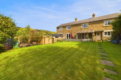
- Price
- £450,000
- Size
- 0.2 acres
The Barn, Burnfoot, St Johns Chapel, DL13, Stanhope, County Durham DL13 England
Added on 01/08/2026Barn Conversion
- Price
- Offers Over£350,000
- Size
- 0.77 acres
Moor Lane, Dalton, Richmond, Dalton, North Yorkshire DL11 England
Added on 29/01/2026Development Land