North Close, Kirk Merrington, Spennymoor, Durham, DL16
- Land size
- 1.2 acres
- Bedrooms
- 3
- Bathrooms
- 1
Description
Strategically positioned within an enviable plot of approximately 1.2 acres in the charming hamlet of North Close, Kirk Merrington, this individual detached residence represents a rare and significant opportunity. Elevated and enjoying far-reaching panoramic views across open countryside towards Durham Cathedral and Penshaw Monument, the setting alone distinguishes this home from the ordinary.
Held within the same family for almost a century and never before offered to the open market, the property carries with it a tangible sense of heritage. It is a home that has evolved over generations rich in character, beautifully positioned, and now ready for its next chapter.
The approach is impressive. A sweeping driveway curves through established grounds, creating an immediate sense of arrival while providing extensive parking and access to the detached garage and additional outbuildings. The house itself sits proudly within the plot, framed by structured planting, mature hedging and shaped topiary, with tiered sections of lawn and stone retaining walls adding depth and architectural interest.
Internally, the accommodation offers substantial proportions, with flexibility to adapt and enhance subject to individual requirements. The principal lounge is an elegant and generously scaled reception room, reflective of the home’s original character. High ceilings, deep skirting boards and decorative picture rails reinforce its period integrity, while the expansive footprint allows for multiple seating arrangements without compromising flow. A striking bay window projects outwards, framing elevated views across the front garden and beyond, flooding the space with natural light and creating an inviting seating nook. A tiled fireplace provides a central focal point, anchoring the room and offering clear scope for enhancement should a purchaser wish to introduce a more contemporary statement feature. The scale and symmetry of this room make it equally suited to formal entertaining or relaxed family living.
The kitchen continues the theme of character and authenticity. Arranged in a traditional galley configuration, cabinetry runs along both sides to maximise storage and functionality, with original fitted cupboards extending to ceiling height. Stainless steel work surfaces and a double sink introduce a practical, utilitarian finish, while large windows draw in natural light. At its heart sits a classic cream Aga a defining feature that enhances warmth and reinforces the home’s longstanding heritage. Open shelving and additional storage provide practicality, and the proportions present exciting scope for sympathetic modernisation or reconfiguration, subject to individual vision.
Externally, the grounds are simply exceptional. Expansive lawns stretch out from the house, framed by mature trees, established borders and structured hedging that create both privacy and definition. Beyond the more formal gardens, the landscape transitions into a more natural setting with tree-lined boundaries and elevated vantage points that fully capitalise on the breathtaking views. From these higher sections of the plot, uninterrupted sightlines extend across rolling countryside towards Durham’s iconic landmarks a perspective rarely secured within a residential setting.
Multiple zones within the grounds provide versatility, whether for family use, gardening enthusiasts, or those seeking space for future enhancement, subject to the necessary consents. Existing outbuildings offer practical storage and further potential for hobby or workshop use.
This is not simply a detached home; it is a generational opportunity. A property defined by land, elevation, heritage and potential positioned between Spennymoor and Kirk Merrington to the south of Durham, yet feeling wonderfully private and secluded. For a purchaser seeking scale, views and the chance to shape a landmark home for the future, North Close presents a truly compelling proposition.
Material Information
Local Authority – Durham County Council Council Tax Band – E Tenure – Freehold Property Type – Detached Property Construction – Standard Electricity supply – Mains Water Supply – Mains Sewerage – Mains Heating – Mains gas Estimated Mobile phone coverage – EE: good, Three: poor, 02: OK, Vodafone: OK Estimated Broadband Download speeds – Basic: 10mb, Ultrafast: 1800mb Rights & Easements – To be confirmed during the conveyancing process Flood risk – Very low Coastal Erosion – Not applicable Protected Trees – No Conservation area – No Planning Permission – No Accessibility – No accessibility features Mining Area – Situated in a former mining area Selective License Area – No
Map Location
Property details
- Tenure
- Freehold
- Council Tax Band
- TBC
- Date Posted
- 2026-03-14
Market Value Analysis
Compared with 210 Homes with Land listings in North East England (1+ acres).
Energy Performance Certificate
Energy Efficiency Rating
Based on UK Energy Performance Certificate standards (EU Directive 2002/91/EC)
Running costs are one side. Planning activity, flood history and ground risks for this location are in the full report.
Utilities & Restrictions
Utilities
- Electricity
- Ask Agent
- Water
- Ask Agent
- Heating
- Ask Agent
- Broadband
- Ask Agent
- Sewerage
- Ask Agent
Rights & Restrictions
- Public Rights of Way
- Ask Agent
- Private Rights of Way
- Ask Agent
- Listed Property
- Ask Agent
- Restrictions
- Ask Agent
Listed status, conservation areas and planning constraints for this location are in the full report.
Property Features
- Accessibility
- Ask Agent
- Parking
- Parking Available
- Garden
- Garden
Beyond the particulars: planning activity, flood history, heritage and ground risks, checked for this exact spot.
Connectivity
Broadband
Fastest speed available at this postcode
10 Gbps
Gigabit full fibre · available to 64% of premises
Suitable for
- 4K streaming on every screen
- Full-time home working
- Online gaming & big downloads
Mobile signal
Outdoor predictions; indoor signal depends on building materials.
Ofcom Connected Nations postcode-level predictions. Speeds and signal are modelled, not measured, and vary between addresses and providers.
Signal is the easy part. Planning activity, flood history and protected designations here are in the full report.
Nearest Schools
Primary
- Kirk Merrington Primary School970 metresOfsted: Outstanding
- Ages
- 4 to 11
- Pupils
- 180
- Type
- Community school
- Middlestone Moor Academy0.8 milesOfsted report card · Feb 2026
- Ages
- 2 to 11
- Pupils
- 265
- Type
- Academy converter
- Rosa Street Primary and Nursery Academy1.1 milesOfsted: Good
- Ages
- 2 to 11
- Pupils
- 245
- Type
- Academy sponsor led
- North Park Primary School1.3 milesOfsted: Good
- Ages
- 2 to 11
- Pupils
- 243
- Type
- Community school
- King Street Primary School1.4 milesOfsted: Good
- Ages
- 2 to 11
- Pupils
- 224
- Type
- Community school
Secondary
- Ferryhill School0.9 milesNo Ofsted rating
- Ages
- 11 to 16
- Pupils
- 727
- Type
- Academy converter
- Whitworth Park Academy1.1 milesOfsted: Good
- Ages
- 11 to 16
- Pupils
- 996
- Type
- Academy sponsor led
- King James I Academy Bishop Auckland3.3 milesOfsted report card · Mar 2026
- Ages
- 11 to 18
- Pupils
- 936
- Type
- Academy converter
- Parkside Academy4 milesOfsted: Good
- Ages
- 11 to 16
- Pupils
- 833
- Type
- Academy converter
- Woodham Academy4.1 milesNo Ofsted rating
- Ages
- 11 to 16
- Pupils
- 1,071
- Type
- Academy converter
Distances are straight-line from the advertised location. Source: the national school registers (DfE, Welsh Government, Scottish Government) and Ofsted.
Schools are just the start: sold prices nearby, planning activity and any flood history are in the full report.
Amenities
Supermarket
GP surgery
Pharmacy
Hospital
Green space
Straight-line distances from the advertised location. Sources: NHS records, Geolytix supermarket locations, OS Open Greenspace and the national trails registers.
The area stacks up? Now check the location itself: planning nearby, protected designations and past flooding.
Getting Around
Nearest station
Nearest bus stop
Typical drive times
Straight-line distances from the advertised location; drive times are typical free-flow times over OpenStreetMap road data, so allow more at peak. Public transport locations from DfT NaPTAN.
Easy to reach matters. So do planning activity, flood history and ground risks: all in the full report.
Flood Risk
From Environment Agency flood map open data, checked around the advertised map pin and allowing for the listed acreage where known. This summary comes from LandSale, the advertising platform, not from the listing agent, and is not part of the agent's particulars. Risk can vary across a single holding, so verify anything critical through your own searches before committing.
Rivers and the sea
Surface water
The detail behind these bandings
The full report pinpoints where this location sits on the flood maps, and runs the deeper checks that usually only surface after an offer.
- Exact flood zones & annual chances (included in the full report)
- Any recorded past flooding (included in the full report)
- Planning activity nearby (included in the full report)
- Heritage & conservation (included in the full report)
- Protected nature designations (included in the full report)
- Ground risks (included in the full report)
- Sold prices nearby (included in the full report)
£14.99 · one-off purchase
By LandSale, the platform. Not provided by the listing agent. Ready in about a minute.
Important notice: Information, maps and tags on this page are drawn from the advertising agent's marketing materials or generated automatically. LandSale has not verified them. Relying on these details is at your own risk, always carry out independent checks before committing to a purchase.
LandSale full disclaimer
Marketing information only - not formal particulars. The details on this website are provided for general guidance and do not constitute an offer or contract. Neither LandSale nor the advertising estate/land agent accepts responsibility for any inaccuracy.
1. Source of information
- Listing content: Core description, asking price, tenure, measurements, photographs and planning history originate from the marketing materials of the advertising estate or land agent. LandSale does not author this content and cannot guarantee its accuracy.
- Automated tags & categorisation: Property type, land-use class, acreage bands and similar labels may be applied by machine-learning models. They are intended as a helpful guide only and may not reflect the property's legal status or permitted use.
- Third-party & enriched data layers: Maps, boundary outlines, planning designations, soil reports, broadband coverage and other environmental or location-based insights are licensed from external suppliers. Such data are supplied “as is", may be incomplete or out of date and are subject to change without notice.
2. Verification required
Prospective purchasers must verify critical matters, including but not limited to planning permission, title boundaries, public rights of way, environmental constraints, acreage, services, access and VAT status, through their own inspections, specialist surveys, legal advisers and the selling agent before relying on the information or entering into any contract.
3. No warranty or liability
LandSale gives no warranty, express or implied, as to the accuracy, completeness or fitness for any particular purpose of the information displayed. LandSale shall not be liable for any loss, damage, cost or expense arising directly or indirectly from any use of or reliance on such information, save where liability may not be excluded by law.
4. Updates & feedback
If you believe any detail on this listing is inaccurate, please let us know. We will investigate and, where appropriate, update the listing or notify the agent.
© LandSale | Version 1.3 - August 2026
Listing agent
Ryan James Estate Agents, Bishop Auckland
136 Newgate Street, Bishop Auckland, DL14 7EH
View agent profileSimilar properties for sale
- Price
- £590,000
- Size
- 3 acres
Added on 30/07/2026House with Land
- Price
- Offers Over£575,000
- Size
- 1 acres
Station Houses, Bishop Auckland, DL14, Bishop Auckland, County Durham DL14 England
Added on 11/05/2026House with Land
- Price
- Offers Over£500,000
Rushyford, Ferryhill, Durham, DL17, Windlestone, County Durham DL17 England
Added on 31/03/2026Barn Conversion
- Price
- Guide Price£545,000
- Size
- 1 acres
Billy Hall Farm, Billy Rowe, DL15, Bishop Auckland, County Durham DL15 England
Added on 29/05/2026House with Land
- Price
- Guide Price£550,000
Strawberry Hill Barn, Old Cassop, DH6, Cassop-cum-Quarrington, County Durham DH6 England
Added on 25/04/2026Barn Conversion
- Price
- £575,000
- Size
- 2 acres
Added on 05/03/2026Equestrian property
- Price
- Offers Over£400,000
Evenwood Gate, Bishop Auckland, Evenwood and Barony, County Durham DL14 England
Added on 24/07/2026Barn Conversion
- Price
- £425,000
- Size
- 1.1 acres
Added on 28/01/2026Development Land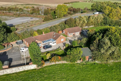
- Price
- £465,000
- Size
- 1 acres
Burtree Lane, Darlington, DL3, Whessoe, Darlington DL3 England
Added on 08/06/2026House with Land
- Price
- Offers in Region of£450,000
Sacriston Lane, Witton Gilbert, Durham, DH7, Witton Gilbert, County Durham DH7 England
Added on 12/05/2026Barn Conversion