The Dog & Gun Inn, Skelton, Cumbria
- Bedrooms
- 3
- Bathrooms
- 2
Key Features
- Holds 1 Michelin Star and 3 AA Rosettes
- Family-owned Gastropub in a Charming Village Setting
- Highly Profitable based on Food & Drink and with Limited Opening Hours
- Restaurant, Bar, Kitchen, and Owner Accommodation Included
- Close to Lake District, M6 Motorway & West Coast Mainline
- Characterful 18th Century Building
Description
The Dog & Gun Inn, Skelton - A Rare Michelin-Starred Freehold Opportunity
Nestled within the small village of Skelton on the peaceful northern fringes of the Lake District,
the Dog & Gun Inn offers a high-quality, authentic rural dining experience. Located just
seven miles from the transport hub of Penrith, and only four miles from the M6, it is ideally
positioned for both local residents and visitors exploring the region. This independent, family
owned establishment has earned a prestigious national reputation, proudly holding one
Michelin Star since 2022 and three AA Rosettes since 2023, distinctions that firmly position it as
a destination restaurant for those seeking a truly special meal in an authentic Cumbrian pub
setting. Known for its warm welcome and refined yet relaxed atmosphere, the Dog & Gun
attracts both locals and gastronomic tourists, standing out as one of the region’s culinary
highlights.
One of the many outstanding qualities of the Dog & Gun is its idyllic village location, surrounded
by gently rolling countryside and characteristic Cumbrian charm. Inside, the Dog & Gun
combines comfort with understated authenticity, which enhances the appeal of the national
accreditations. As a celebrated gastropub, it offers a dining experience shaped by
exceptional locally sourced ingredients, thoughtful craftsmanship, and a commitment to quality
that has earned acclaim from globally recognised directories of gastronomic excellence.
Beyond its acclaimed cuisine, the Dog & Gun serves as an inviting base for those wishing to
explore the surrounding area. Skelton’s advantageous location places visitors within easy reach
of both the Lake District’s dramatic landscapes, and the historic market towns of Keswick and
Penrith. With scenic walking routes, picturesque villages, and a wealth of local attractions
nearby, it is an ideal stop for food-loving adventurers and those seeking a peaceful rural retreat.
The property itself comprises of a ground-floor restaurant area, including a welcoming bar and
back-bar, along with a professional, fully equipped commercial kitchen designed for the
precision required of Michelin-level service. Upstairs, arranged across the first and second
floors, are additional preparation rooms and generous living accommodation, making it well
suited to anyone seeking an owner-occupied operation, or for expansion of the hospitality
offering through conversion into guest suites (subject to planning) to further diversify revenue.
With its award-winning reputation, charming village setting, and proximity to some of Cumbria’s
most celebrated scenery, the Dog & Gun Inn offers potential for a seamless transition with
continued brand prestige of some of the industry's highest accolades. Its blend of Michelin
recognized dining, genuine hospitality, and enviable location ensures it remains a jewel within
the region - a rare chance to purchase a business with a well-established and enduring appeal.
Vestibule (Ground Floor) - 1.081 x 1.071 (3'6" x 3'6") -
Dining Area One (Ground Floor) - 8.441 x 4.613 (27'8" x 15'1") -
Dining Area Two (Ground Floor) - 5.728 x 3.351 (18'9" x 10'11") -
Bar Area (Ground Floor) - 2.945 x 1.772 (9'7" x 5'9") -
Back Bar Area (Ground Floor) - 4.059 x 1.523 (13'3" x 4'11") -
Restaurant Kitchen (Ground Floor) - 3.106 x 3.058 (10'2" x 10'0") -
Gents (Ground Floor) - 3.820 x 1.327 (12'6" x 4'4") -
Ladies (Ground Floor) - 2.857 x 1.720 (9'4" x 5'7") -
Prep Room (First Floor) - 4.588 x 3.598 (15'0" x 11'9") -
Store/Freezer Room (First Floor) - 3.601 x 3.439 (11'9" x 11'3") -
Reception Room (First Floor) - 4.562 x 2.608 (14'11" x 8'6") -
Residential Kitchen (First Floor) - 3.266 x 2.925 (10'8" x 9'7") -
Bathroom (First Floor) - 2.738 x 1.735 (8'11" x 5'8") -
Bedroom One (Second Floor) - 4.444 x 3.916 (14'6" x 12'10") -
Bedroom Two (Second Floor) - 4.457 x 2.809 (14'7" x 9'2") -
Bedroom Three (Second Floor) - 4.416 x 2.684 (14'5" x 8'9") -
Bathroom (Second Floor) - 2.484 x 1.491 (8'1" x 4'10") -
Map Location
Property details
- Tenure
- Freehold
- Council Tax Band
- Ask Agent
- Date Posted
- 2026-01-30
Utilities & Restrictions
Utilities
- Electricity
- Mains
- Water
- Mains
- Heating
- Electric Heating, Night Storage Heaters, Wood Burner
- Broadband
- Ask Agent
- Sewerage
- Mains
Rights & Restrictions
- Public Rights of Way
- Ask Agent
- Private Rights of Way
- Yes
- Listed Property
- Ask Agent
- Restrictions
- Yes
Listed status, conservation areas and planning constraints for this location are in the full report.
Property Features
- Accessibility
- Ask Agent
- Parking
- On-Street Parking
- Garden
- Ask Agent
Beyond the particulars: planning activity, flood history, heritage and ground risks, checked for this exact spot.
Connectivity
Broadband
Fastest speed available at this postcode
950 Mbps
Gigabit full fibre · available to 89% of premises
Suitable for
- 4K streaming on every screen
- Full-time home working
- Online gaming & big downloads
Fixed wireless access may also be an option here.
Mobile signal
Predicted 4G and 5G signal; indoor signal depends on building materials.
Ofcom Connected Nations postcode-level predictions. Speeds and signal are modelled, not measured, and vary between addresses and providers.
Signal is the easy part. Planning activity, flood history and protected designations here are in the full report.
Nearest Schools
Primary
- Skelton School98 metresOfsted: Good
- Ages
- 3 to 11
- Pupils
- 87
- Type
- Community school
- Greystoke Primary School2.9 milesOfsted report card · Apr 2026
- Ages
- 3 to 11
- Pupils
- 51
- Type
- Community school
- Calthwaite CofE School3.6 milesNo Ofsted rating
- Ages
- 4 to 11
- Pupils
- 69
- Type
- Voluntary aided school
- Faith
- Church of England
- Plumpton School4 milesOfsted report card · Feb 2026
- Ages
- 3 to 11
- Pupils
- 102
- Type
- Community school
- Penruddock Primary School4.8 milesOfsted report card · Jan 2026
- Ages
- 3 to 11
- Pupils
- 48
- Type
- Foundation school
Secondary
- Queen Elizabeth Grammar School Penrith5.9 milesOfsted: Good
- Ages
- 11 to 18
- Pupils
- 1,026
- Type
- Academy converter
- Ullswater Community College6.2 milesOfsted: Good
- Ages
- 11 to 18
- Pupils
- 1,520
- Type
- Foundation school
- Caldew School10 milesOfsted: Good
- Ages
- 11 to 18
- Pupils
- 990
- Type
- Academy converter
- St John Henry Newman Catholic School12 milesOfsted: Good
- Ages
- 11 to 18
- Pupils
- 703
- Type
- Voluntary aided school
- Faith
- Roman Catholic
- Richard Rose Morton Academy12 milesOfsted: Good *
- Ages
- 11 to 18
- Pupils
- 905
- Type
- Academy sponsor led
* Latest graded judgement covers quality of education only; no overall grade was issued under the 2024-25 inspection framework.
Distances are straight-line from the advertised location. Source: the national school registers (DfE, Welsh Government, Scottish Government) and Ofsted.
Schools are just the start: sold prices nearby, planning activity and any flood history are in the full report.
Amenities
Supermarket
GP surgery
Pharmacy
Hospital
Green space
Straight-line distances from the advertised location. Sources: NHS records, Geolytix supermarket locations, OS Open Greenspace and the national trails registers.
The area stacks up? Now check the location itself: planning nearby, protected designations and past flooding.
Getting Around
Nearest station
Nearest bus stop
Typical drive times
Straight-line distances from the advertised location; drive times are typical free-flow times over OpenStreetMap road data, so allow more at peak. Public transport locations from DfT NaPTAN.
Easy to reach matters. So do planning activity, flood history and ground risks: all in the full report.
Flood Risk
Environment Agency open data, checked around the advertised map pin for the listed acreage. Long-term risk counts flood defences; the planning map's flood zones do not. The map pin for this listing marks the postcode area rather than the exact location, so these readings describe the surrounding area. Provided by LandSale, not the listing agent, and not part of the agent's particulars. Risk varies across a holding, so verify before committing.
Rivers and the sea
Planning map: Flood Zone 1.
Surface water
These bandings are the summary. Where this location sits on the flood maps, plus planning activity, heritage and ground risks, is in the full report.
Important notice: Information, maps and tags on this page are drawn from the advertising agent's marketing materials or generated automatically. LandSale has not verified them. Relying on these details is at your own risk, always carry out independent checks before committing to a purchase.
LandSale full disclaimer
Marketing information only - not formal particulars. The details on this website are provided for general guidance and do not constitute an offer or contract. Neither LandSale nor the advertising estate/land agent accepts responsibility for any inaccuracy.
1. Source of information
- Listing content: Core description, asking price, tenure, measurements, photographs and planning history originate from the marketing materials of the advertising estate or land agent. LandSale does not author this content and cannot guarantee its accuracy.
- Automated tags & categorisation: Property type, land-use class, acreage bands and similar labels may be applied by machine-learning models. They are intended as a helpful guide only and may not reflect the property's legal status or permitted use.
- Third-party & enriched data layers: Maps, boundary outlines, planning designations, soil reports, broadband coverage and other environmental or location-based insights are licensed from external suppliers. Such data are supplied “as is", may be incomplete or out of date and are subject to change without notice.
2. Verification required
Prospective purchasers must verify critical matters, including but not limited to planning permission, title boundaries, public rights of way, environmental constraints, acreage, services, access and VAT status, through their own inspections, specialist surveys, legal advisers and the selling agent before relying on the information or entering into any contract.
3. No warranty or liability
LandSale gives no warranty, express or implied, as to the accuracy, completeness or fitness for any particular purpose of the information displayed. LandSale shall not be liable for any loss, damage, cost or expense arising directly or indirectly from any use of or reliance on such information, save where liability may not be excluded by law.
4. Updates & feedback
If you believe any detail on this listing is inaccurate, please let us know. We will investigate and, where appropriate, update the listing or notify the agent.
© LandSale | Version 1.3 - August 2026
Listing agent
Corrie and Co Ltd, Ulverston
14 King Street, Ulverston, LA12 7DZ
Similar properties for sale
 Added on 29/01/2026Commercial Land
- Price
- Guide Price£500,000
- Size
- 3.23 acres
The Old Tile Works, Culgaith, Penrith, Cumbria CA10, Culgaith, Westmorland and Furness CA10 England
Added on 17/07/2026Commercial Land
- Price
- £875,000
- Size
- 0.25 acres
Syke Park Industrial Estate, Syke Road, Wigton, CA7, Wigton, Cumberland CA7 England
Added on 17/07/2026Warehouse
- Price
- Guide Price£975,000
- Size
- 5.96 acres
Beech Villa, Wigton, Cumbria, Woodside, Cumberland CA7 England
Added on 04/09/2026Commercial Land Added on 14/07/2026Pub
- Price
- Guide Price£455,000
- Size
- 2.4 acres
Added on 17/09/2026Development Land Added on 24/09/2026Pub
- Price
- Offers in Region of£450,000
Penny Bridge, Ulverston, Egton with Newland, Westmorland and Furness LA12 England
Added on 29/01/2026Pub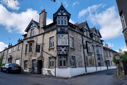
- Price
- £895,000
Added on 29/01/2026Pub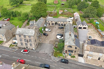
- Price
- Offers in Excess of£650,000
The Ancient Unicorn, Bowes, Barnard Castle, DL12, Bowes, County Durham DL12 England
Added on 17/07/2026Commercial Land