Residential Development site, Spalding Road, Pinchbeck, PE11 3UE
- Land size
- 0.89 acres
Description
LOCATION
** Residential Development Site with Full Planning Consent for 5 Dwellings - Located Mid-Way between Pinchbeck and Spalding - Site Approximately 0.89 acres (0.36 Ha) **
The site is situated in a very pleasant location at Spalding Road, Pinchbeck, being about ¾ mile from the village of Pinchbeck and 1½ miles to the town centre of Spalding. Pinchbeck itself offers a range of village stores, Primary School, Church and Public Houses. Further shopping and extensive facilities are available in the nearby town of Spalding, as well as Secondary Schools and train station.
It also lies within half a mile of the A16, within 14 miles of Boston and 20 miles from Peterborough. Onward access to the A17 is within 6 miles drive providing good access to Kings Lynn and beyond to the North Norfolk coastal resorts. The A16 Spalding Bypass provides easy access to Peterborough with its onwards fast train journeys to London´s Kings Cross (within about 50 minutes). Spalding station also connects to Peterborough to the south and Sleaford, Lincoln and Doncaster to the north.
DESCRIPTION
The total area of the site extends to approximately 0.89 Acres (0.36 Hectares), and is shown contained within these particulars edged red (excluding the land edged green). The site is shown on the plan on the front of these Particulars (for identification purposes only). It comprises the site of the former Glen Farrow premises. The site has access over a joint made-up roadway from Spalding Road used in common by the site and others.
0.89 Acres (0.36 Hectares) Outline Consent for 5 dwellings
Adjacent sites have recently been developed for residential dwellings.
SERVICES
Mains electricity, gas, BT and water connections have already been brought to the site/site boundary. A main foul sewer passes close to the site entrance with existing manhole connections making for ease of connection thereto (subject to Anglian Water Group´s consent). A plan showing the run of the main sewer is included in these Particulars for information purposes.
Neither the Vendors nor their Agents make any guarantees as to the availability of services and interested parties must make their own enquiries direct with the service providers concerned as to the cost of providing all necessary services as required. The purchaser will be responsible for all costs associated with the provision of such services.
PLANNING
Full Planning Consent was granted by South Holland District Council under Reference Nos: H14-0633-21 dated 14 December 2021 for the development of the site. The plans for the Planning Consent show a layout for 5 dwellings with garages, off a shared driveway. The discharge of consent conditions has yet to be made, including an Archaeological Study. The development is required to have a ´private´ refuse/recycling collection service, when brought into use.
It should be noted that previous planning consents have been granted for 7 No. dwellings and 9 No. dwellings, full details available on SHDC Planning website, and therefore an expectation exists that Planners could give favourable consideration to changes to the density of the current development proposed, should an application be made. Interested parties are advised to make their own enquiries to the Local Planning Authority in this respect.
Prospective purchasers´ attention is drawn to the various conditions attached to the Planning Consents. The costs of fulfilling all planning conditions are the responsibility of the purchaser. A copy of the formal Planning Consents are available from the Council´s website: or from the Agent´s Spalding Office together with other documents associated with the planning applications.
Any queries in respect of planning should be addressed direct to:
South Holland District Council - Planning Department - Call: / Email:
Geotechnical surveys have already been undertaken.
OTHER
FENCING
The rear (east) boundary is in line with the majority of the close board fencing erected at the rear of properties of the new houses on Palgrave Way.
ACCESS
Access to the site is from Spalding Road and is shown on the indicative layout plan accompanying the planning documents.
CONSTRUCTION
Under the terms of the Planning Consent, the properties to be built are to be no lower than 500mm above existing coverage ground level.
For the avoidance of doubt, please note that any stored materials, portacabins etc. which may be on site are
not included within the sale. Some materials may be available For Sale under separate negotiation.
VIEWING
By appointment only - contact R Longstaff & Co LLP Tel: .
NB: The site is uneven in part and parties view at their own risk. Neither the Vendors nor the Agents accept any liability for any damage to persons or property by virtue of viewing the site.
Map Location
Property details
- Tenure
- Freehold
- Council Tax Band
- Ask Agent
- Date Posted
- 2026-01-29
Utilities & Restrictions
Utilities
- Electricity
- Ask Agent
- Water
- Ask Agent
- Heating
- Ask Agent
- Broadband
- Ask Agent
- Sewerage
- Ask Agent
Rights & Restrictions
- Public Rights of Way
- Ask Agent
- Private Rights of Way
- Ask Agent
- Listed Property
- Ask Agent
- Restrictions
- Ask Agent
Property Features
- Accessibility
- Ask Agent
- Parking
- Parking Available
- Garden
- Ask Agent
Important notice: Information, maps and tags on this page are supplied by the advertising agent or generated automatically. LandSale has not verified them. Relying on these details is at your own risk, always carry out independent checks before committing to a purchase.
LandSale full disclaimer
Marketing information only - not formal particulars. The details on this website are provided for general guidance and do not constitute an offer or contract. Neither LandSale nor the advertising estate/land agent accepts responsibility for any inaccuracy.
1. Source of information
- Agent-supplied content: Core description, asking price, tenure, measurements, photographs and planning history are uploaded by the appointed agent, who remains solely responsible for their accuracy.
- Automated tags & categorisation: Property type, land-use class, acreage bands and similar labels may be applied by machine-learning models. They are intended as a helpful guide only and may not reflect the property's legal status or permitted use.
- Third-party & enriched data layers: Maps, boundary outlines, planning designations, soil reports, broadband coverage and other environmental or location-based insights are licensed from external suppliers. Such data are supplied “as is", may be incomplete or out of date and are subject to change without notice.
2. Verification required
Prospective purchasers must verify critical matters, including but not limited to planning permission, title boundaries, public rights of way, environmental constraints, acreage, services, access and VAT status, through their own inspections, specialist surveys, legal advisers and the selling agent before relying on the information or entering into any contract.
3. No warranty or liability
LandSale gives no warranty, express or implied, as to the accuracy, completeness or fitness for any particular purpose of the information displayed. LandSale shall not be liable for any loss, damage, cost or expense arising directly or indirectly from any use of or reliance on such information, save where liability may not be excluded by law.
4. Updates & feedback
If you believe any detail on this listing is inaccurate, please let us know. We will investigate and, where appropriate, update the listing or notify the agent.
© LandSale | Version 1.2 - January 2026
Listing agent
Longstaff Chartered Surveyors, Spalding
5 New Road, Spalding, PE11 1BS
Similar properties for sale

- Price
- Guide Price£595,000
- Size
- 0.89 acres
Added on 29/01/2026Development Land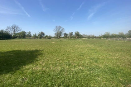
- Price
- Guide Price£450,000
- Size
- 1.2 acres
Land off High Street, Rippingale, Rippingale, Lincolnshire PE10 0SR England
Added on 18/04/2026Development Land
- Price
- £450,000
- Size
- 1.2 acres
Land off High Street, Rippingale, Rippingale, Lincolnshire PE10 0SR England
Added on 18/04/2026Development Land
- Price
- £650,000
- Size
- 3.97 acres
Residential Development Site, Tydd St Mary, Tydd St Mary, Lincolnshire PE13 5QP England
Added on 13/06/2026Development Land
- Price
- £495,000
- Size
- 0.45 acres
Wormgate, Boston, Lincolnshire, PE21 6NS, Boston and Skegness, Lincolnshire PE21 6NS England
Added on 01/07/2026Development Land
- Price
- £485,000
- Size
- 1.5 acres
Mouth Lane, Guyhirn, PE13, Wisbech St. Mary, Cambridgeshire PE13 4ES England
Added on 25/03/2026Building Plot
- Price
- Offers in Region of£600,000
Land Off, Southgate, Sleaford, Lincolnshire, NG34, Sleaford, Lincolnshire NG34 7RY England
Added on 29/01/2026Development Land
- Price
- £500,000
- Size
- 0.35 acres
Market Street, Whittlesey, Peterborough, Whittlesey, Cambridgeshire PE7 1BD England
Added on 12/06/2026Development Land
- Price
- £500,000
- Size
- 0.5 acres
Wansford Marina, Elton Road, Wansford, Sibson-cum-Stibbington, Cambridgeshire PE8 6LH England
Added on 29/01/2026Building Plot Added on 28/04/2026Development Land