And 6 Acres, Ambleston, SA62
- Land size
- 6 acres
Key Features
- Potential Building Plot
- With 6 Acres
Description
Situated in the heart of the Village, a potential Building Plot (on which Planning Consent has recently expired) together with some 6 acres or thereabouts of mainly level lying and gently sloping Pasture Land. Rarely do potential Building Plots and Land become available on the “Open Market” and the opportunity to purchase should not be missed. Early inspection is strongly advised. Realistic Price Guide.
Situation
Ambleston is a small village which stands some 7 miles or so North East of the County and Market Town of Haverfordwest.Ambleston has the benefit of a Post Office, Chapel and a Church and within 3 miles or so is the larger village of Spittal which has the benefit of a Primary School, Church, Public House and a weekly visit by a Mobile Post Office Van.Some 4 miles or so North West is the larger village of Letterston which has the benefit of several Shops, a Post Office, a General Store, Public House, a Fish & Chip Shop Restaurant/Take-Away, Church, Chapels, a Licensed Restaurant, Primary School and a Petrol Filling Station/Store. The Pembrokeshire Coastline at Abercastle is within 9 miles or so and also within easy reach are the other well known Sandy Beaches and Coves at The Parrog, Pwllcrochan, Abermawr, Aberbach, Aberfelin, Porthgain, Traeth Llyfn, Abereiddy and Whitesands Bay.
Description
The potential Building Plot is formerly part of Croft House which stands in the heart of this popular rural village.
The potential Building Plot has a frontage of approximately 40’ onto the Council Maintained District Road and an average depth of approximately 105’. The potential Building Plot is registered with The Land Registry and is referred to as Title Number CYM574075. A copy of The Land Registry Plan is attached.
Adjoining the potential Plot is approximately 6 acres or thereabouts of mainly level lying and gently sloping Pasture Land which is registered at The Land Registry under Title Number WA731100. There is a natural water supply on the North Western boundary
A Plan of the potential Plot and the 6 Acres or thereabouts of Accommodation Land is coloured red on a Plan, that is available from the Fishguard Office.
A copy of the Outline Planning Permission in relation to the Plot is attached which was granted on the 11th April 2005.
Services
Mains Water, Electricity and Drainage are available in the vicinity of the Property, but not connected to the potential Building Plot nor the Land.
Tenure
The entire Property is of Freehold Tenure with Vacant Possession upon Completion.
General Remarks
Potential Building Plots together with 6 acres or thereabouts of Land are few and far between and the opportunity to purchase should not be missed. The Property is situated in the heart of this popular rural village on which Outline Planning Consent for one Dwelling on the Plot of Land concerned has now lapsed. Rarely do potential Plots together with adjoining Land become available on the “Open Market” and the opportunity to purchase should not be missed. Realistic Price Guide.
Directions from Fishguard
From Fishguard, take the Main A40 Road South for some 5 miles passing through the village of Letterston and half a mile or so further on, take the second turning on the left signposted to Sealyham. Continue on this road for some 2 miles or so passing through two sets of crossroads and a half a mile or so further on, follow the road 900 to the right. Continue on this road for a few hundred yards through another set of crossroads and some 4/500 yards or so further on, take the turning on the right for Ambleston Village. Continue on this road for 400 yards or so and in the village of Ambleston the potential Plot and 6 acres of Land is situated on the right hand side of the road. A “For Sale” board is erected on site.
Directions from Haverfordwest
Alternatively from Haverfordwest, take the Main A40 Road North for some 3 miles and take the turning on the right adjacent to The Corner Piece Public House. Continue on this road for a mile or so passing through a set of crossroads and some 2 miles or so further on, take the turning on the right for Ambleston. Continue on this road for approximately a mile and upon reaching Ambleston Village proceed past the Church and some 100 yards or so further on, the potential Plot and 6 acres of Land is situated on the left hand side of the road. A “For Sale” board is erected on site.
Map Location
Property details
- Tenure
- Ask Agent
- Council Tax Band
- Ask Agent
- Date Posted
- 2026-01-29
Market Value Analysis
Compared with 5 Building Plots listings in Wales (5+ acres).
Utilities & Restrictions
Utilities
- Electricity
- Ask Agent
- Water
- Ask Agent
- Heating
- Ask Agent
- Broadband
- Ask Agent
- Sewerage
- Ask Agent
Rights & Restrictions
- Public Rights of Way
- Ask Agent
- Private Rights of Way
- Ask Agent
- Listed Property
- Ask Agent
- Restrictions
- Ask Agent
Property Features
- Accessibility
- Ask Agent
- Parking
- Ask Agent
- Garden
- Ask Agent
Important notice: Information, maps and tags on this page are supplied by the advertising agent or generated automatically. LandSale has not verified them. Relying on these details is at your own risk, always carry out independent checks before committing to a purchase.
LandSale full disclaimer
Marketing information only - not formal particulars. The details on this website are provided for general guidance and do not constitute an offer or contract. Neither LandSale nor the advertising estate/land agent accepts responsibility for any inaccuracy.
1. Source of information
- Agent-supplied content: Core description, asking price, tenure, measurements, photographs and planning history are uploaded by the appointed agent, who remains solely responsible for their accuracy.
- Automated tags & categorisation: Property type, land-use class, acreage bands and similar labels may be applied by machine-learning models. They are intended as a helpful guide only and may not reflect the property's legal status or permitted use.
- Third-party & enriched data layers: Maps, boundary outlines, planning designations, soil reports, broadband coverage and other environmental or location-based insights are licensed from external suppliers. Such data are supplied “as is", may be incomplete or out of date and are subject to change without notice.
2. Verification required
Prospective purchasers must verify critical matters, including but not limited to planning permission, title boundaries, public rights of way, environmental constraints, acreage, services, access and VAT status, through their own inspections, specialist surveys, legal advisers and the selling agent before relying on the information or entering into any contract.
3. No warranty or liability
LandSale gives no warranty, express or implied, as to the accuracy, completeness or fitness for any particular purpose of the information displayed. LandSale shall not be liable for any loss, damage, cost or expense arising directly or indirectly from any use of or reliance on such information, save where liability may not be excluded by law.
4. Updates & feedback
If you believe any detail on this listing is inaccurate, please let us know. We will investigate and, where appropriate, update the listing or notify the agent.
© LandSale | Version 1.2 - January 2026
Listing agent
JJ Morris, Fishguard
21 West Street, Fishguard, SA65 9AL
Similar properties for sale

- Price
- Guide Price£165,000
- Size
- 14.69 acres
At New Holmus, Little Newcastle, SA62, Puncheston, Pembrokeshire SA62 5TB Wales
Added on 29/01/2026Pasture
- Price
- £165,000
- Size
- 33.61 acres
Puncheston, Haverfordwest, SA66, Puncheston, Pembrokeshire SA66 7RG Wales
Added on 29/01/2026Agricultural Land
- Price
- Guide Price£120,000
- Size
- 20.28 acres
Tresissyllt, St Nicholas, SA64, Pencaer, Pembrokeshire SA64 0LJ Wales
Added on 21/05/2026Agricultural Land
- Price
- Offers in Region of£185,000
- Size
- 26.51 acres
Land at Dale Road, Haverfordwest SA62, Tiers Cross, Pembrokeshire SA62 3AB Wales
Added on 29/01/2026Agricultural Land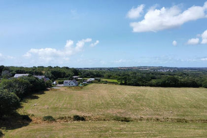
- Price
- Offers in Region of£125,000
- Size
- 14.34 acres
Targate Road, Freystrop, SA62, Freystrop, Pembrokeshire SA62 4EY Wales
Added on 09/07/2026Vacant Land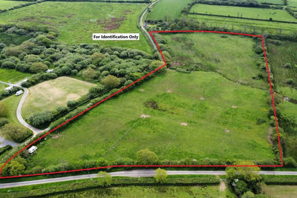
- Price
- Fixed Price£115,000
- Size
- 11.51 acres
Cresselly, Kilgetty, SA68, Carew, Pembrokeshire SA68 0TP Wales
Added on 19/05/2026Grazing Land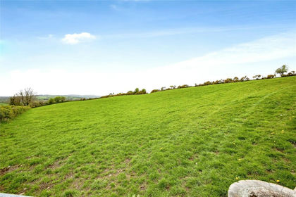
- Price
- £130,000
- Size
- 9 acres
Tegryn, Llanfyrnach, Pembrokeshire, SA35, Clydau, Pembrokeshire SA35 0BJ Wales
Added on 30/06/2026Grazing Land
- Price
- £150,000
- Size
- 15 acres
Winllan, Boncath, SA37, Boncath, Pembrokeshire SA37 0JR Wales
Added on 29/01/2026Agricultural Land
- Price
- £120,000
- Size
- 13.32 acres
Hodgeston, Pembroke, SA71, Lamphey, Pembrokeshire SA71 5JU Wales
Added on 28/01/2026Agricultural Land
- Price
- £140,000
- Size
- 15.43 acres
Penybont, Carmarthen, SA33, Trelech, Carmarthenshire SA33 6PN Wales
Added on 29/01/2026Grazing Land