Pencroesoped, Llanover, Abergavenny, NP7
- Land size
- 2.34 acres
- Bedrooms
- 3
- Bathrooms
- 3
Key Features
- Detached cottage with barns and stabling
- Wonderful position and views
- Running alongside the Canal
- Total of 2.34 acres including gardens and paddock
- Superbly finished inside
- Air source heating and sola pannels
Description
The property beautifully presented throughout, the property currently provides comfortable three-bedroom accommodation, whilst the adjoining traditional outbuildings offer considerable potential for a variety of future uses, subject to obtaining the necessary consents.
The welcoming entrance hall with useful storage area leads to a generous sitting room centred around a wood-burning stove, creating a warm and inviting space to relax. Across the hall, the impressive kitchen/dining room forms the heart of the home, offering excellent entertaining space with ample room for family dining and direct access to the garden. A useful utility room and cloakroom complete the ground floor. The first floor offers three generous double bedrooms, two enjoying en-suite shower rooms, together with a contemporary family bathroom finished to a high standard.
The Kiln is complemented by substantial ancillary stone outbuildings attached to the property with potential for development. Detailed architectural proposals have been prepared to convert the outbuildings which adjoin the house into additional living accommodation. The proposals do not currently benefit from an extant planning permission; however detailed architectural proposals exist. Copies of the drawings and relevant documentation are available from the selling agents.
Outside
The Kiln is approached via a private driveway; the property benefits from a generous garden, plenty of room for parking, a stable block and has an approximately 1.60-acre paddock behind, all of which overlook open countryside. The property extends in total to approximately 2.34 acres.
The garden is secure and provides an ideal space for outdoor dining, family life and entertaining. The useful stable block and paddock are conveniently placed for equestrian or amenity use.
The Monmouthshire & Brecon Canal runs immediately alongside the eastern side of the property, which creates an idyllic backdrop, offering peaceful walks, cycling and wildlife.
Location
The Kiln lies on the edge of Llanover in an attractive rural position between Abergavenny and Usk and is surrounded by beautiful Monmouthshire countryside with the Monmouthshire & Brecon Canal running alongside the property.
The nearby market town of Abergavenny, known as the “Gateway to Wales”, is approximately 5.5 miles away and provides an excellent range of independent shops, cafés, restaurants and supermarkets, together with primary and secondary schools, leisure facilities and the renowned annual Food Festival.
The area is a haven for those who enjoy the outdoors. The canal towpath offers scenic walks and cycling, whilst the surrounding countryside, the Bannau Brycheiniog (Brecon Beacons) National Park and the Black Mountains provide endless opportunities for walking, riding and outdoor pursuits.
For those needing to commute, the property is well placed for the A40 and A465, providing convenient links to Monmouth, Hereford, Newport, Cardiff and the motorway network. Abergavenny railway station also offers regular services to Cardiff, Newport, Hereford, Bristol, Birmingham and London.
Despite its tranquil setting, The Kiln combines the best of country living with excellent accessibility, making it an ideal choice as either a permanent family home or a rural retreat.
General
Postcode: NP7 9EL
Local Authority: Monmouthshire County Council
Services: Mains electricity, mains water and private drainage
(septic tank), air-source heat pump and solar panels. To the best of our knowledge, the private drainage system is compliant and benefits from a historic Natural Resources Wales (NRW) exemption registered in 2011, though no separate compliance inspection has been commissioned.
Council Tax Band: F
EPC Rating: C
Fixtures and Fittings: Only those items known as fixtures and fittings will be included in the sale. Certain items may be available by separate negotiation.
Reservations: A reserved right of way for agricultural use only as shown on sales plan.
Wayleaves or easements: The property is sold subject to any wayleaves or easements, whether mentioned in these particulars or not.
Mobile coverage and broadband: Information can be found here:
Map Location
Property details
- Tenure
- Freehold
- Council Tax Band
- F
- Date Posted
- 2026-09-18
Market Value Analysis
Compared with 1,207 Homes with Land listings in Wales (1+ acres).
Energy Performance Certificate
Energy Efficiency Rating
Based on UK Energy Performance Certificate standards (EU Directive 2002/91/EC)
Running costs are one side. Planning activity, flood history and ground risks for this location are in the full report.
Utilities & Restrictions
Utilities
- Electricity
- Mains, Solar Panels
- Water
- Mains
- Heating
- Double Glazing, Air Source Heat Pump
- Broadband
- Ask Agent
- Sewerage
- Septic Tank / Private
Rights & Restrictions
- Public Rights of Way
- Ask Agent
- Private Rights of Way
- Ask Agent
- Listed Property
- Ask Agent
- Restrictions
- Ask Agent
Listed status, conservation areas and planning constraints for this location are in the full report.
Property Features
- Accessibility
- Ask Agent
- Parking
- Parking Available
- Garden
- Garden
Beyond the particulars: planning activity, flood history, heritage and ground risks, checked for this exact spot.
Connectivity
Broadband
Fastest speed available at this postcode
1.8 Gbps
Gigabit full fibre · available to 67% of premises
Suitable for
- 4K streaming on every screen
- Full-time home working
- Online gaming & big downloads
Mobile signal
Outdoor predictions; indoor signal depends on building materials.
Ofcom Connected Nations postcode-level predictions. Speeds and signal are modelled, not measured, and vary between addresses and providers.
Signal is the easy part. Planning activity, flood history and protected designations here are in the full report.
Nearest Schools
Primary
- Goytre Fawr Primary1.6 miles
- Pupils
- 182
- Type
- Infants & Juniors
- Language
- English medium school / provision
- Ysgol Bryn Onnen2.9 miles
- Pupils
- 174
- Type
- Infants & Juniors
- Language
- Welsh medium school / provision (including transitional)
- Garnteg Primary3.2 miles
- Pupils
- 384
- Type
- Nursery, Infants & Juniors
- Language
- English medium school / provision
- Ysgol Gymraeg Gwynllyw3.3 miles
- Pupils
- 808
- Type
- Middle (ages 3-19)
- Language
- Welsh medium school / provision (including transitional)
- Penygarn Community Primary School3.6 miles
- Pupils
- 368
- Type
- Nursery, Infants & Juniors
- Language
- English medium school / provision
Secondary
- Ysgol Gymraeg Gwynllyw3.3 miles
- Pupils
- 808
- Type
- Middle (ages 3-19)
- Language
- Welsh medium school / provision (including transitional)
- Abersychan Comprehensive3.3 miles
- Pupils
- 739
- Type
- Secondary (ages 11-16)
- Language
- English medium school / provision
- St. Albans R.C. High School4.1 miles
- Pupils
- 824
- Type
- Secondary (ages 11-16)
- Language
- English medium school / provision
- West Monmouth School4.5 miles
- Pupils
- 1,149
- Type
- Secondary (ages 11-16)
- Language
- English medium school / provision
- King Henry VIII 3195.2 miles
- Pupils
- 1,310
- Type
- Middle (ages 3-19)
- Language
- English medium school / provision
Distances are straight-line from the advertised location. Source: the national school registers (DfE, Welsh Government, Scottish Government) and Ofsted.
Schools are just the start: sold prices nearby, planning activity and any flood history are in the full report.
Amenities
Supermarket
GP surgery
Pharmacy
Straight-line distances from the advertised location. Sources: NHS records, Geolytix supermarket locations, OS Open Greenspace and the national trails registers.
The area stacks up? Now check the location itself: planning nearby, protected designations and past flooding.
Getting Around
Nearest station
Nearest bus stop
Typical drive times
Straight-line distances from the advertised location; drive times are typical free-flow times over OpenStreetMap road data, so allow more at peak. Public transport locations from DfT NaPTAN.
Easy to reach matters. So do planning activity, flood history and ground risks: all in the full report.
Flood Risk
From Natural Resources Wales flood map open data, checked around the advertised map pin and allowing for the listed acreage where known. This summary comes from LandSale, the advertising platform, not from the listing agent, and is not part of the agent's particulars. Risk can vary across a single holding, so verify anything critical through your own searches before committing.
Rivers and the sea
Surface water
These bandings are the summary. Where this location sits on the flood maps, plus planning activity, heritage and ground risks, is in the full report.
Important notice: Information, maps and tags on this page are drawn from the advertising agent's marketing materials or generated automatically. LandSale has not verified them. Relying on these details is at your own risk, always carry out independent checks before committing to a purchase.
LandSale full disclaimer
Marketing information only - not formal particulars. The details on this website are provided for general guidance and do not constitute an offer or contract. Neither LandSale nor the advertising estate/land agent accepts responsibility for any inaccuracy.
1. Source of information
- Listing content: Core description, asking price, tenure, measurements, photographs and planning history originate from the marketing materials of the advertising estate or land agent. LandSale does not author this content and cannot guarantee its accuracy.
- Automated tags & categorisation: Property type, land-use class, acreage bands and similar labels may be applied by machine-learning models. They are intended as a helpful guide only and may not reflect the property's legal status or permitted use.
- Third-party & enriched data layers: Maps, boundary outlines, planning designations, soil reports, broadband coverage and other environmental or location-based insights are licensed from external suppliers. Such data are supplied “as is", may be incomplete or out of date and are subject to change without notice.
2. Verification required
Prospective purchasers must verify critical matters, including but not limited to planning permission, title boundaries, public rights of way, environmental constraints, acreage, services, access and VAT status, through their own inspections, specialist surveys, legal advisers and the selling agent before relying on the information or entering into any contract.
3. No warranty or liability
LandSale gives no warranty, express or implied, as to the accuracy, completeness or fitness for any particular purpose of the information displayed. LandSale shall not be liable for any loss, damage, cost or expense arising directly or indirectly from any use of or reliance on such information, save where liability may not be excluded by law.
4. Updates & feedback
If you believe any detail on this listing is inaccurate, please let us know. We will investigate and, where appropriate, update the listing or notify the agent.
© LandSale | Version 1.3 - August 2026
Listing agent
James Dean, Abergavenny
59 Frogmore Street, Abergavenny, NP7 5AR
Similar properties for sale
- Price
- Guide Price£895,000
- Size
- 14 acres
Added on 29/01/2026Cottage
- Price
- Offers Over£700,000
- Size
- 1.13 acres
Added on 21/03/2026House with Land
- Price
- Guide Price£650,000
- Size
- 3 acres
Added on 24/07/2026House with Land
- Price
- Guide Price£680,000
- Size
- 1.5 acres
Added on 29/01/2026House with Land
- Price
- Guide Price£650,000
- Size
- 1.5 acres
Prioress Mill Lane, Usk, Llanbadoc, Monmouthshire NP15 Wales
Added on 29/01/2026House with Land
- Price
- Offers Over£670,000
- Size
- 1.5 acres
The Mill House Llanbadoc, Llanbadoc, Monmouthshire NP15 Wales
Added on 29/01/2026Country Home
- Price
- £895,000
- Size
- 1 acres
Pentwyn Lane, Govilon, Abergavenny, Llanfoist Fawr, Monmouthshire NP7 Wales
Added on 29/01/2026Residential
- Price
- £800,000
- Size
- 1 acres
Added on 28/01/2026Barn Conversion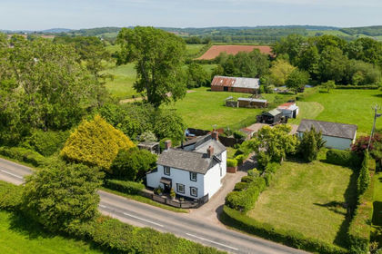
- Price
- £975,000
- Size
- 3 acres
Added on 22/06/2026House with Land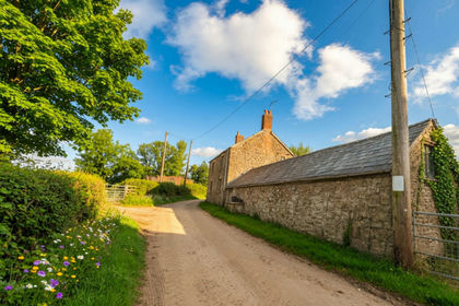
- Price
- Offers in Excess of£700,000
- Size
- 14 acres
Wernrheolydd, Usk, NP15, Whitecastle, Monmouthshire NP15 Wales
Added on 08/08/2026House with Land