Apple Tree Cottage Building Plot, Upper Basildon
- Land size
- 0.5 acres
Description
APPLE TREE COTTAGE BUILDING PLOT
UPPER BASILDON - BERKSHIRE
READING - 7 miles OXFORD - 19 miles HENLEY on THAMES - o13 miles
NEWBURY - 10 miles M4 (J12) - 6 miles M40 (J6) - 15 miles HEATHROW - 40 miles
Mainline Railway Station to LONDON PADDINGTON within the hour - 2 miles
(Distances and times approximate)
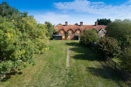
Situated on the fringe of this most desirable village adjoining paddocks, yet just a short distance of the village primary school, and extensive shops in Pangbourne, Goring, Newbury, or Reading, and for the mainline train station providing direct access to London Paddington in under the hour, a delightfully mature individual plot of approximately half of an acre in size, having the benefit of *planning permission for a stunning detached home extending to approximately 4,114 sq ft, affording generous open plan and well apportioned living in stylish and a contemporary architect designed build, with a wonderful setting afforded.
A wonderful development opportunity afforded, in a stunning setting, early viewing is advised.
LOCATION
The village of Upper Basildon sits on the edge of the Berkshire Downs in an Area of Outstanding Natural Beauty with far reaching views of the scenic countryside surrounding it on all sides. The village offers a range of amenities including a parish church, community Post Office, highly regarded C of E primary school, and a soon to be re-opening traditional Public House, as well as a splendid village hall which has become the centre for a variety of community activities and sports, utilising the adjoining sports field and tennis courts. A local bus company runs a limited service from the village to Pangbourne, Reading, Streatley and Goring on Thames, where there are mainline railway stations with fast commuter services up to London (Paddington) in well under an hour (25 minutes from Reading).
Bradfield College, a well-known public school just three miles from Upper Basildon, has excellent leisure, fitness and sports facilities including a large indoor swimming pool which are all open to members of the public; Facilities also include squash, badminton and tennis courts, hockey and a 9-hole golf course. In addition to having revered and outstanding state primary and secondary schooling, including a primary school within the village itself, the area is also extremely well served by an excellent range of private schools; of particular note are: Bradfield College, Cranford House School, The Oratory Preparatory School, Moulsford Preparatory School, St Andrews Preparatory School, The Oratory School, Pangbourne College, Brockhurst & Marlston House, Queen Anne’s School, Downe House, Rupert House School, Shiplake College, The Abbey School, The Manor Preparatory School, Abingdon School, Abingdon Preparatory School, Radley College, and St Helen & St Katharine.
The nearby larger villages of either Pangbourne or Goring-on-Thames offers a wide range of amenities and facilities including shops, butchers and bakeries, hardware’s, galleries, modern health centres, beauticians, traditional inns, restaurants, cafes, and hotels, libraries, dentists and much more.
There is also easy access for the major local towns, including Oxford, Reading and Newbury, the M40 and M4 motorways, the latter linking directly to Heathrow.
PROPERTY DESCRIPTION
A rare opportunity to acquire a substantial self-build or development plot with planning permission approved (subject only to a £1,692 carbon offset S106 payment). This is an exception, individual designed residence extending to approximately 4,114 sq ft. Including a 5 bedroom, 4 reception, 4 bathroom property with detached garage and adjoining store / studio, incorporating stunning traditional architectural design features, blending seamlessly with more contemporary notes, embracing a modern open plan living space internally with wide and tall glazing embracing both light and landscape in equal measure.
Situated well set back from the village centre, enjoying a quiet and attractive location overlooking adjoining paddocks and woodland beyond, the gardens and grounds extend to approximately half of an acre, enjoying great privacy and tranquillity in this quintessentially charming English village, with extensive walks just a short hop from its doorstep, in addition to London in under the hour. (*Awaiting planning permission decision validation, subject to finalised 106 agreement.)
Please see the West Berkshire Council planning portal for full details of the planning permission, quoting the planning reference 25/01252/FUL or, enquire at the offices of Warmingham & Co.
A wonderful opportunity afforded, for either a private buyer looking to build their dream home or, development companies seeking a development opportunity, early viewing is advised.
GENERAL INFORMATION
Services: Whilst mains water and electricity are both available for connection, in addition to GigaClear ultrafast broadband, of up to 900mbs, interested parties should make their own enquiries of the relevant utility companies as to further connections.
Council Tax Band: TBC
Community Infrastructure Liability Reference: TBC
Community Infrastructure Liability: Estimated @ £65,000 (Those occupying the residence once built should be eligible for 100% exemption)
Postcode: RG8 8LN
Local Authority: West Berkshire District Council
VIEWING
For health and safety reason all viewings must be accompanied by Warmingham & Co.
DIRECTIONS
From Warmingham & Co offices in the centre of Goring turn left and proceed down the High Street, across the river bridge and up to the top of Streatley High Street where at the traffic lights turn left signposted for Pangbourne. On reaching Lower Basildon in approximately 2 miles, turn right opposite the garage into Park Wall Lane. Follow this road into the village of Upper Basildon at which point Park Wall Lane becomes Bethesda Street, where you turn immediately left into Blandy’s Lane. Proceed along until reaching the central part of the village, and after having just turned left on to Pangbourne Road, Apple Tree Cottage Building Plot will be found directly opposite the village church.
DISCLAIMER
The agent has not tested any apparatus, equipment, fittings or services so cannot verify that they are in working order. If required, the client is advised to obtain verification. These particulars are issued on the understanding that all negotiations are conducted through Warmingham & Co. Whilst all due care is taken in the preparation of these particulars, no responsibility for their accuracy is accepted, nor do they form part of any offer or contract. Intending clients must satisfy themselves by inspection or otherwise as to their accuracy prior to signing a contract.
Map Location
Property details
- Tenure
- Freehold
- Council Tax Band
- Ask Agent
- Date Posted
- 2026-09-15
Utilities & Restrictions
Utilities
- Electricity
- Ask Agent
- Water
- Ask Agent
- Heating
- Ask Agent
- Broadband
- Ask Agent
- Sewerage
- Ask Agent
Rights & Restrictions
- Public Rights of Way
- Ask Agent
- Private Rights of Way
- Ask Agent
- Listed Property
- Ask Agent
- Restrictions
- Ask Agent
Listed status, conservation areas and planning constraints for this location are in the full report.
Property Features
- Accessibility
- Ask Agent
- Parking
- Parking Available
- Garden
- Garden
Beyond the particulars: planning activity, flood history, heritage and ground risks, checked for this exact spot.
Connectivity
Broadband
Fastest speed available at this postcode
1 Gbps
Gigabit full fibre
Suitable for
- 4K streaming on every screen
- Full-time home working
- Online gaming & big downloads
Mobile signal
Outdoor predictions; indoor signal depends on building materials.
Ofcom Connected Nations postcode-level predictions. Speeds and signal are modelled, not measured, and vary between addresses and providers.
Signal is the easy part. Planning activity, flood history and protected designations here are in the full report.
Nearest Schools
Primary
- Basildon C.E. Primary School862 metresNo Ofsted rating
- Ages
- 2 to 11
- Type
- Academy converter
- Faith
- Church of England
- Pangbourne Primary School2.6 milesNo Ofsted rating
- Ages
- 4 to 11
- Pupils
- 107
- Type
- Community school
- Whitchurch Primary School2.6 milesOfsted: Good
- Ages
- 4 to 11
- Pupils
- 136
- Type
- Community school
- Yattendon C.E. Primary School2.9 milesNo Ofsted rating
- Ages
- 4 to 11
- Pupils
- 92
- Type
- Voluntary aided school
- Faith
- Church of England
- Englefield C.E. Primary School2.9 milesOfsted: Good *
- Ages
- 4 to 11
- Pupils
- 106
- Type
- Voluntary aided school
- Faith
- Church of England
Secondary
- Denefield School3.5 milesOfsted: Good
- Ages
- 11 to 18
- Pupils
- 1,171
- Type
- Academy converter
- Theale Green School3.7 milesOfsted report card · Apr 2026
- Ages
- 11 to 18
- Pupils
- 803
- Type
- Academy sponsor led
- Little Heath School3.8 milesNo Ofsted rating
- Ages
- 11 to 18
- Pupils
- 1,682
- Type
- Voluntary aided school
- Langtree School4.8 milesOfsted: Good
- Ages
- 11 to 16
- Pupils
- 626
- Type
- Academy converter
- The Downs School5.5 milesOfsted: Outstanding *
- Ages
- 11 to 18
- Type
- Academy converter
* Latest graded judgement covers quality of education only; no overall grade was issued under the 2024-25 inspection framework.
Distances are straight-line from the advertised location. Source: the national school registers (DfE, Welsh Government, Scottish Government) and Ofsted.
Schools are just the start: sold prices nearby, planning activity and any flood history are in the full report.
Amenities
Supermarket
GP surgery
Pharmacy
Hospital
Green space
Straight-line distances from the advertised location. Sources: NHS records, Geolytix supermarket locations, OS Open Greenspace and the national trails registers.
The area stacks up? Now check the location itself: planning nearby, protected designations and past flooding.
Getting Around
Nearest station
Nearest bus stop
Typical drive times
Straight-line distances from the advertised location; drive times are typical free-flow times over OpenStreetMap road data, so allow more at peak. Public transport locations from DfT NaPTAN.
Easy to reach matters. So do planning activity, flood history and ground risks: all in the full report.
Flood Risk
From Environment Agency flood map open data, checked around the advertised map pin and allowing for the listed acreage where known. This summary comes from LandSale, the advertising platform, not from the listing agent, and is not part of the agent's particulars. Risk can vary across a single holding, so verify anything critical through your own searches before committing.
Rivers and the sea
Surface water
These bandings are the summary. Where this location sits on the flood maps, plus planning activity, heritage and ground risks, is in the full report.
Important notice: Information, maps and tags on this page are drawn from the advertising agent's marketing materials or generated automatically. LandSale has not verified them. Relying on these details is at your own risk, always carry out independent checks before committing to a purchase.
LandSale full disclaimer
Marketing information only - not formal particulars. The details on this website are provided for general guidance and do not constitute an offer or contract. Neither LandSale nor the advertising estate/land agent accepts responsibility for any inaccuracy.
1. Source of information
- Listing content: Core description, asking price, tenure, measurements, photographs and planning history originate from the marketing materials of the advertising estate or land agent. LandSale does not author this content and cannot guarantee its accuracy.
- Automated tags & categorisation: Property type, land-use class, acreage bands and similar labels may be applied by machine-learning models. They are intended as a helpful guide only and may not reflect the property's legal status or permitted use.
- Third-party & enriched data layers: Maps, boundary outlines, planning designations, soil reports, broadband coverage and other environmental or location-based insights are licensed from external suppliers. Such data are supplied “as is", may be incomplete or out of date and are subject to change without notice.
2. Verification required
Prospective purchasers must verify critical matters, including but not limited to planning permission, title boundaries, public rights of way, environmental constraints, acreage, services, access and VAT status, through their own inspections, specialist surveys, legal advisers and the selling agent before relying on the information or entering into any contract.
3. No warranty or liability
LandSale gives no warranty, express or implied, as to the accuracy, completeness or fitness for any particular purpose of the information displayed. LandSale shall not be liable for any loss, damage, cost or expense arising directly or indirectly from any use of or reliance on such information, save where liability may not be excluded by law.
4. Updates & feedback
If you believe any detail on this listing is inaccurate, please let us know. We will investigate and, where appropriate, update the listing or notify the agent.
© LandSale | Version 1.3 - August 2026
Listing agent
Warmingham & Co, Goring-on-Thames
4- 5 High Street Goring-on-Thames Reading RG8 9AT
Contact Warmingham & Co, Goring-on-Thames
4- 5 High Street Goring-on-Thames Reading RG8 9AT
View agent profileSimilar properties for sale
- Price
- Guide Price£825,000
- Size
- 0.27 acres
Added on 29/01/2026Development Land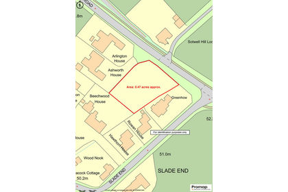
- Price
- Guide Price£700,000
High Road, Wallingford, OX10, Brightwell-cum-Sotwell, Oxfordshire OX10 England
Added on 01/08/2026Development Land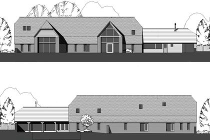
- Price
- £850,000
- Size
- 1 acres
Added on 29/01/2026Development Land- Price
- £850,000
- Size
- 1 acres
Church Street, West Hanney, Wantage, Oxfordshire, West Hanney, Oxfordshire OX12 England
Added on 29/01/2026Development Land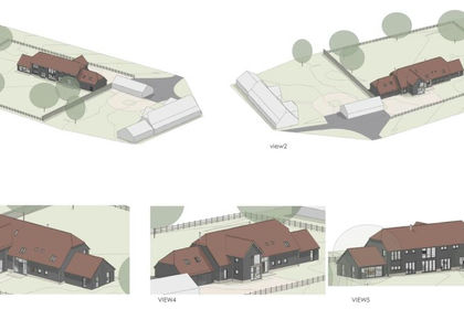
- Price
- £850,000
- Size
- 1 acres
Church Street, West Hanney, Wantage, Oxfordshire, West Hanney, Oxfordshire OX12 England
Added on 29/01/2026Development Land
- Price
- £795,000
- Size
- 0.31 acres
Vigo Lane, Yateley, Hampshire, GU46, Yateley, Hampshire GU46 England
Added on 27/03/2026Undeveloped Land
- Price
- Offers in Region of£850,000
- Size
- 1 acres
Sturt Green, Maidenhead, SL6, Bray, Windsor and Maidenhead SL6 England
Added on 08/09/2026Building Plot
- Price
- £600,000
- Size
- 5 acres
Faringdon Road, Stanford In The Vale, Faringdon, Stanford in the Vale, Oxfordshire SN7 England
Added on 28/01/2026Conversion Land
- Price
- £660,000
- Size
- 7 acres
Faringdon Road, Stanford In The Vale, Faringdon, Stanford in the Vale, Oxfordshire SN7 England
Added on 28/01/2026Conversion Land
- Price
- £575,000
- Size
- 8.08 acres
Added on 14/09/2026Conversion Land