Evesham Road, Harvington, Nr. Evesham
- Land size
- 5.4 acres
Key Features
- For Sale by Public Auction on Tuesday 13th October 2026
Description
The above property will be offered for sale by public auction (subject to prior sale, reserve and conditions) at 6.30pm on Tuesday 13th October 2026 at The View, Hill Farm Marina, Stratford Road, Wootton Wawen, Warwickshire, B95 6DE (///glance.dance.rival).
Introduction - This well-located parcel of land, extending to approximately 5.40 acres (2.19 ha) is located just off the B4088, between the villages of Norton and Harvington.
Initially established as a commercial walnut orchard, enclosed on three sides by hybrid Poplars, noted for their vigour and drought tolerance. Within the parcel are planted hybrid Walnuts, vigorous and grown for the timber trade, it is considered that in a few years’ time, these will be of harvestable size. The main wooded area contains a mixture of Oaks, including Scarlet Oak, Maples, including Sugar Maple and Norway Maple from seed imported from the USA/Canada, Black Walnuts, English Oak and Cherries. There are a number of Grey Alders, Medlar, Sweet Chestnut and Willow, together with ‘Shag Bark’ Hickories, which have now reached fruiting age.
The under-storey has a mixture of flora and fauna, with, in the spring, orchids, etc.. Various game birds, pheasant, partridge, etc. utilise the cover of the under-storey, and woodcock have been regularly spotted on the land, probably migrants from eastern Europe.
With such a rich diversity of trees, the autumn colours are spectacular and the whole is indeed a paradise for wildlife.
It is felt that there might be some scope for the sympathetic installation (STPP) of perhaps glamping pods?, off-grid and environmentally friendly, for those wishing to commune with nature,. Perhaps further enhance the mix of diverse woodland species as a private nature reserve, or looking to the future, manage and husband the trees for specialist timber production, veneers and marquetry.
It goes without saying, that opportunities such as this do not become available very often in this area, and early viewing is encouraged to appreciate all that this land has to offer.
General Information -
Services - Prospective purchasers should make their own enquiries with the appropriate utility companies for the verification as to the availability (or otherwise) of services, although it is understood that mains water is available on the land, and an electricity supply is available nearby.
Authorities - Worcestershire Couty Council (
Wychavon District Council (
Severn Trent Water Ltd (
National Grid (
Tenure And Possession - The land is freehold. Completion is scheduled for 28 days after the auction, i.e. Tuesday 10th November 2026 (or earlier by mutual agreement). On the fall of the hammer, the successful purchaser will be required to sign the auction contract and pay a 10% deposit (minimum £5,000) to the vendor’s solicitors, together with an administration fee of £950 (plus VAT) to the auctioneers, if the land is sold in the room on the night, prior to or post auction.
Tenant Right - There will be no ingoing valuation for UMVs/RMVs and no claim for dilapidations (if any) will be entertained from the purchaser(s).
Rights Of Way And Easements - The property is sold subject to all rights of way and easements that may exist.
Boundaries And Timber - All growing timber is included in the sale. The ownership of the boundaries (where known) is delineated by an inward facing ‘T’ mark.
Sporting And Mineral Rights - Sporting and mineral rights, where owned, are included in the sale of the freehold.
Plans - Plans shown are for identification purposes only.
Flood Risk - This location is in 'Flood Zone 1' (Low Probability). For more information, please visit:
Broadband And Mobile Coverage - Superfast broadband speed is available in the area, with a predicted highest available download speed of 42 Mbps and a predicted highest available upload speed of 8 Mbps. Mobile signal coverage is available from the four major providers (EE, O2, Three and Vodafone).
EE - Good Outdoor
O2 - Good Outdoor
Three - Good Outdoor
Vodafone – Good Outdoor
For more information, please visit:
Vendor's Solicitor - A full auction pack will be available from:
Tolhurst Fisher
Trafalgar House
Nelson Street
Southend-on-Sea
Essex
SS1 1EF
Acting: Mr Charles Latham
Email:
Telephone:
Viewing - The land may be inspected by prospective purchasers, strictly by prior appointment only, through the auctioneers, Earles, Henley-in-Arden. Tel: (during daylight hours only and at viewers’ own risk). All gates must be left as found, no litter left and no dogs whatsoever are permitted on the land.
Directions - From Birmingham, M42 (J3) and the north, take the A435 south past Redditch and through Studley, to Alcester, joining the A46 dual carriageway signposted to Evesham. At the Twyford roundabout, turn right, signposted to Worcester and at the next roundabout turn right onto the B4088. Pass through the village of Norton and go straight on at the mini roundabout. The land will be found after approximately a quarter of a mile on the left hand side, as indicated by the Earles auction boards.
From the M5, Worcester and the east, take the A44 signposted to Evesham. Pass over the Cropthorne roundabout, signposted to Stratford upon Avon. At the next roundabout turn left onto the B4088 and follow the directions as above.
From The Cotswolds, Broadway and the east, take the A44 to join the Evesham bypass, heading north over the River Avon to the Twyford roundabout, bearing left, signposted to Worcester. At the second roundabout turn right onto the B4088 and follow the directions as above.
Approximate Postcode: WR11 8NT
What3Words: ///tricks.smarter.opened
Conditions Of Sale - The property will, unless previously withdrawn, be sold subject to the Special and General Conditions of Sale, which have been settled by the vendor’s solicitor. These conditions may be inspected during the usual office hours at the offices of the vendor’s solicitor mentioned in these sales particulars during the five days, exclusive of Saturday and Sunday, immediately before and exclusive of the day of the sale. The conditions may also be inspected in the Sale Room at the time of the sale, but they will not then be read. The purchaser shall be deemed to bid on those terms whether he shall have inspected the Conditions or not.
Money Laundering - Money Laundering Regulations have been introduced by the government, affecting auctioneers, under the Proceeds of Crime Act 2002/Money Laundering Regulations 2007. To comply with this Act, we require all purchasers to pay the deposit by any of the following methods: Bank/Building Society Draft, Personal/Company Cheque. All purchasers will be required to provide proof of both their identity and current address and all parties intending to purchase any property must bring with them the following items: Full UK Passport or Photo Driving Licence (for identification), a recent Utility Bill, Council Tax Bill or Bank Statement (as proof of residential address). These should be presented to the vendor’s solicitor when signing the contract.
Agent's Note - The guide price offers an indication of the price below which the vendor is not willing to sell. It is not necessarily the exact final sale price and is subject to change prior to and up until the day of the auction. Any change in the guide price will reflect a change in the reserve (a figure below which the auctioneer will not be able to sell). The reserve can be expected to be set within the guide range or not more than 10% above a single figure guide (RICS Common Auction Conditions 7th Edition).
Earles is a Trading Style of 'John Earle & Son LLP' Registered in England. Company No: OC326726 for professional work and 'Earles Residential Ltd' Company No: 13260015 Agency & Lettings. Registered Office: Carleton House, 266 - 268 Stratford Road, Shirley, West Midlands, B90 3AD.
Map Location
Property details
- Tenure
- Freehold
- Council Tax Band
- Ask Agent
- Date Posted
- 2026-08-28
Market Value Analysis
Compared with 10 Woodland listings in West Midlands (5+ acres).
Utilities & Restrictions
Utilities
- Electricity
- Ask Agent
- Water
- Ask Agent
- Heating
- Ask Agent
- Broadband
- Ask Agent
- Sewerage
- Ask Agent
Rights & Restrictions
- Public Rights of Way
- Ask Agent
- Private Rights of Way
- Ask Agent
- Listed Property
- Ask Agent
- Restrictions
- Ask Agent
Listed status, conservation areas and planning constraints for this location are in the full report.
Property Features
- Accessibility
- Ask Agent
- Parking
- Ask Agent
- Garden
- Garden
Beyond the particulars: planning activity, flood history, heritage and ground risks, checked for this exact spot.
Connectivity
Broadband
Fastest speed available at this postcode
42 Mbps
Superfast
Suitable for
- HD streaming
- Video calls
- Web & social
Mobile signal
Outdoor predictions; indoor signal depends on building materials.
Ofcom Connected Nations postcode-level predictions. Speeds and signal are modelled, not measured, and vary between addresses and providers.
Signal is the easy part. Planning activity, flood history and protected designations here are in the full report.
Nearest Schools
Primary
- Harvington CofE First School0.6 milesOfsted: Outstanding
- Ages
- 3 to 10
- Pupils
- 176
- Type
- Voluntary controlled school
- Faith
- Church of England
- Offenham Church of England First School1.5 milesNo Ofsted rating
- Ages
- 4 to 10
- Pupils
- 97
- Type
- Academy converter
- Faith
- Church of England
- Church Lench CofE First School2.2 milesOfsted: Good
- Ages
- 5 to 10
- Pupils
- 71
- Type
- Academy converter
- Faith
- Church of England
- Salford Priors CofE Academy2.4 milesOfsted: Good *
- Ages
- 5 to 11
- Pupils
- 25
- Type
- Academy sponsor led
- Faith
- Church of England
- The Littletons Church of England Academy2.4 milesOfsted: Good *
- Ages
- 2 to 10
- Pupils
- 150
- Type
- Academy converter
- Faith
- Church of England
Secondary
- St Egwin's CofE Middle School2.5 milesOfsted: Good *
- Ages
- 10 to 13
- Pupils
- 438
- Type
- Voluntary controlled school
- Faith
- Church of England
- Prince Henry's High School2.6 milesOfsted: Outstanding
- Ages
- 13 to 18
- Pupils
- 1,282
- Type
- Academy converter
- Blackminster Middle School2.6 milesOfsted: Requires improvement
- Ages
- 10 to 13
- Pupils
- 217
- Type
- Community school
- The De Montfort School3.5 milesOfsted: Good
- Ages
- 10 to 18
- Pupils
- 915
- Type
- Academy sponsor led
- Pershore High School6.1 milesOfsted: Requires improvement
- Ages
- 11 to 18
- Pupils
- 1,055
- Type
- Academy converter
* Latest graded judgement covers quality of education only; no overall grade was issued under the 2024-25 inspection framework.
Distances are straight-line from the advertised location. Source: the national school registers (DfE, Welsh Government, Scottish Government) and Ofsted.
Schools are just the start: sold prices nearby, planning activity and any flood history are in the full report.
Amenities
Supermarket
GP surgery
Pharmacy
Hospital
Green space
Straight-line distances from the advertised location. Sources: NHS records, Geolytix supermarket locations, OS Open Greenspace and the national trails registers.
The area stacks up? Now check the location itself: planning nearby, protected designations and past flooding.
Getting Around
Nearest station
Nearest bus stop
Typical drive times
Straight-line distances from the advertised location; drive times are typical free-flow times over OpenStreetMap road data, so allow more at peak. Public transport locations from DfT NaPTAN.
Easy to reach matters. So do planning activity, flood history and ground risks: all in the full report.
Flood Risk
From Environment Agency flood map open data, checked around the advertised map pin and allowing for the listed acreage where known. This summary comes from LandSale, the advertising platform, not from the listing agent, and is not part of the agent's particulars. Risk can vary across a single holding, so verify anything critical through your own searches before committing.
Rivers and the sea
Surface water
Mapped within the area searched, not at the advertised map pin itself.
The detail behind these bandings
The full report pinpoints where this location sits on the flood maps, and runs the deeper checks that usually only surface after an offer.
- Exact flood zones & annual chances (included in the full report)
- Any recorded past flooding (included in the full report)
- Planning activity nearby (included in the full report)
- Heritage & conservation (included in the full report)
- Protected nature designations (included in the full report)
- Ground risks (included in the full report)
- Sold prices nearby (included in the full report)
£14.99 · one-off purchase
By LandSale, the platform. Not provided by the listing agent. Ready in about a minute.
Important notice: Information, maps and tags on this page are drawn from the advertising agent's marketing materials or generated automatically. LandSale has not verified them. Relying on these details is at your own risk, always carry out independent checks before committing to a purchase.
LandSale full disclaimer
Marketing information only - not formal particulars. The details on this website are provided for general guidance and do not constitute an offer or contract. Neither LandSale nor the advertising estate/land agent accepts responsibility for any inaccuracy.
1. Source of information
- Listing content: Core description, asking price, tenure, measurements, photographs and planning history originate from the marketing materials of the advertising estate or land agent. LandSale does not author this content and cannot guarantee its accuracy.
- Automated tags & categorisation: Property type, land-use class, acreage bands and similar labels may be applied by machine-learning models. They are intended as a helpful guide only and may not reflect the property's legal status or permitted use.
- Third-party & enriched data layers: Maps, boundary outlines, planning designations, soil reports, broadband coverage and other environmental or location-based insights are licensed from external suppliers. Such data are supplied “as is", may be incomplete or out of date and are subject to change without notice.
2. Verification required
Prospective purchasers must verify critical matters, including but not limited to planning permission, title boundaries, public rights of way, environmental constraints, acreage, services, access and VAT status, through their own inspections, specialist surveys, legal advisers and the selling agent before relying on the information or entering into any contract.
3. No warranty or liability
LandSale gives no warranty, express or implied, as to the accuracy, completeness or fitness for any particular purpose of the information displayed. LandSale shall not be liable for any loss, damage, cost or expense arising directly or indirectly from any use of or reliance on such information, save where liability may not be excluded by law.
4. Updates & feedback
If you believe any detail on this listing is inaccurate, please let us know. We will investigate and, where appropriate, update the listing or notify the agent.
© LandSale | Version 1.3 - August 2026
Listing agent
Earles, Henley In Arden
74 High Street, Henley-In-Arden, B95 5BX
Similar properties for sale
- Price
- Offers in Region of£100,000
- Size
- 5.48 acres
Sugar Loaf Lane, Iverley, Kinver, Staffordshire DY10 England
Added on 28/01/2026Vacant Land
- Price
- Guide Price£125,000
- Size
- 14.8 acres
Added on 25/08/2026Arable Land
- Price
- Guide Price£90,000
- Size
- 7.49 acres
Added on 26/08/2026Grazing Land
- Price
- Guide Price£120,000
- Size
- 15.46 acres
Westwood Covert, Glazeley, Bridgnorth WV16, Chetton, Shropshire WV16 England
Added on 28/08/2026Woodland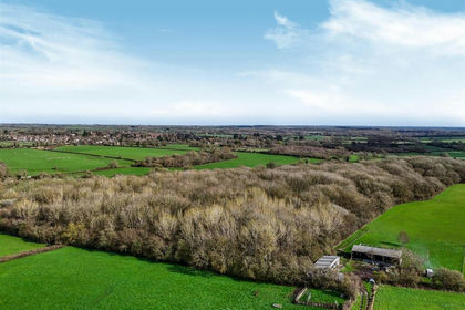
- Price
- Guide Price£75,000
- Size
- 4.33 acres
Added on 14/07/2026Hunting Land