9 Copley Bent, Butterknowle, Bishop Auckland
- Land size
- 11.41 acres
- Bedrooms
- 3
- Bathrooms
- 1
Key Features
- Three Bedrooms
- Semi Detached
- Approximately 4.62 Hectares (11.41 acres) of Grassland
- Semi Rural Location
- Air Source Heating
- Council Tax Band B
- Requires Modernisation
Description
A fantastic opportunity to purchase a three bedroom semi-detached house with outbuildings, garden area and grassland extending to approximately 4.62 Hectares (11.41 acres) set amidst the semi-rural village of Butterknowle.
This property would benefit from updating throughout and presents an exciting opportunity for those seeking a renovation project with substantial scope.
Butterknowle is a friendly village with a strong sense of community, nestled between the scenic North Pennines Area of Outstanding Natural Beauty and rolling County Durham countryside. Local amenities include a well-regarded primary school, village pub, and community centre. Stunning walks and bike rides are available directly from the doorstep, with Hamsterley Forest and the historic market town of Barnard Castle just a short drive away, offering further shops, eateries, and leisure facilities.
Step through the entrance hallway where stairs ascend to the first floor and doors provide access to the ground floor accommodation.
The living room features a bay window overlooking the front elevation, an open fireplace for cosy evenings in, and decorative ceiling coving.
The kitchen is fitted with a selection of wall and floor units, complemented by contrasting work surfaces. Practicalities are catered for with space for a freestanding fridge freezer, plumbing for a washing machine, and room for a slot-in electric cooker. The kitchen also houses the air source heat pump, ensuring efficient heating.
A rear hall leads conveniently to the generous garden as well as the bathroom, which comprises a panelled bath with electric shower, WC, hand wash basin, and an obscured window for privacy.
Upstairs, the first floor landing features a rear-facing window and three bedrooms. Bedroom one overlooks the rear elevation and comes complete with its own WC, hand wash basin, and radiator. Bedroom two is a further double bedroom with views over the front aspect, while bedroom three is a good-sized single room, also front-facing.
The garden, mainly laid to lawn with patio seating areas, is situated to the side of the property, offering plentiful space for outdoor enjoyment. The garden area has the benefit of an existing drop kerb access off the road which could be utilised to create off road parking and or a garage (subject to the necessary consents where applicable)
LAND
The land comprises two enclosures divided by a water course. The northern paddock being more suited to grazing and the southern paddock being capable of mowing or grazing.
GUIDE PRICE
£425,000
SALE PLAN
The property is shown edged red on the attached sale plan.
SERVICES
House: Mains water supply, mains electricity and mains drainage are connected. The property is heated via an air source heat pump. The property has the benefit of solar panels fitted to the roof.
There is a water course present to the land and a water trough which is a metered supply from the mains road supply. There are no other services connected to the land. No warranty is given or implied regarding water quality or continuity of supply.
LOCATION
The property is located on the section of the B6282 known as Copley Bent which runs from Toft Hill to Woodland. Copley Bent lies to east of Copley village and to the south of Butterknowle village. Local amenities are available in Cockfield. A wider range of shops and services is available in Bishop Auckland and Barnard Castle.
House
What3words: ///remainder.retract.deeper
Entrance to the land
What3words: ///vets.quote.equivocal
SPORTING AND MINERAL RIGHTS
Any sporting rights which are owned are included in the sale.
The mineral rights are excluded from the sale.
TENURE
The property is freehold and is registered under title DU382247.
The property is available with vacant possession.
EASEMENTS, WAYLEAVES & RIGHTS OF WAY
The land is sold subject to and with the benefit of all rights of way, drainage, water courses, light and other easements, quasi or reputed easements and rights of adjoining landowners (if any) affecting the same and all matters registerable by any competent authority pursuant subject to statute.
Access to the land is from the adopted highway over third party land (edged green and shaded green on the sale plan) adjacent to 20 Copley Bent.
The land is sold subject to a private right of way which runs from the highway along the track adjacent to the western boundary towards Copley Bent Farm. The crossing point (bridge) over the water course has been installed by the beneficiaries of the right of way. We are advised the seller has no liabilities in respect of repair or maintenance of the bridge.
The land is sold subject to a public right of way (public footpath number 65) which runs from the highway along the track adjacent to the western boundary towards Copley Bent Farm.
The vendor is not aware of any other public or private rights of way over the land.
OVERAGE
The land is sold subject to a development clawback provision (in favour of the vendors and their successors in title). The payment due being equivalent to 25% of the uplift in value arising on the grant of a planning permission for anything other than an agricultural or equestrian use for a term of 50 years.
METHOD OF SALE
The land is offered for sale by private treaty. All interested parties are advised to register their interest so they can be advised on how the sale will be concluded. We reserve the right to proceed to final offers.
COSTS
Each party is to bear their own costs.
LEGAL FORMALITES
Exchange of contracts will take place as soon as possible, but in any event no later than the expiry of 8 weeks from instruction of solicitors, with completion 7 days thereafter.
COUNCIL TAX
Band B- Annual Price- £2,039
LOCAL AUTHORITY
Durham County Council, County Hall, Aykley Heads, Durham DH1 5UL.
Telephone
CONSERVATION AREA
No
MOBILE COVERAGE
O2
BROADBAND
Basic 7 Mbps, Superfast 36 Mbps, Ultrafast 8500 Mbps
SATELLITE/FIBRE TV AVAILABILITY
BT & Sky
VIEWINGS
Viewings will be arranged by the selling Agent.
SURVEY
We have not undertaken a survey of the property and therefore are unable to comment on its structural condition.
BROCHURE
Brochure prepared August 2026
Map Location
Property details
- Tenure
- Freehold
- Council Tax Band
- TBC
- Date Posted
- 2026-08-26
Market Value Analysis
Compared with 35 Homes with Land listings in North East England (10+ acres).
Energy Performance Certificate
Energy Efficiency Rating
Based on UK Energy Performance Certificate standards (EU Directive 2002/91/EC)
Running costs are one side. Planning activity, flood history and ground risks for this location are in the full report.
Utilities & Restrictions
Utilities
- Electricity
- Ask Agent
- Water
- Ask Agent
- Heating
- Ask Agent
- Broadband
- Ask Agent
- Sewerage
- Ask Agent
Rights & Restrictions
- Public Rights of Way
- Ask Agent
- Private Rights of Way
- Ask Agent
- Listed Property
- Ask Agent
- Restrictions
- Ask Agent
Listed status, conservation areas and planning constraints for this location are in the full report.
Property Features
- Accessibility
- Ask Agent
- Parking
- Parking Available
- Garden
- Garden
Beyond the particulars: planning activity, flood history, heritage and ground risks, checked for this exact spot.
Connectivity
Broadband
Fastest speed available at this postcode
8.5 Gbps
Gigabit full fibre
Suitable for
- 4K streaming on every screen
- Full-time home working
- Online gaming & big downloads
Mobile signal
Outdoor predictions; indoor signal depends on building materials.
Ofcom Connected Nations postcode-level predictions. Speeds and signal are modelled, not measured, and vary between addresses and providers.
Signal is the easy part. Planning activity, flood history and protected designations here are in the full report.
Nearest Schools
Primary
- Butterknowle Primary School556 metresOfsted report card · Feb 2026
- Ages
- 3 to 11
- Pupils
- 54
- Type
- Community school
- Cockfield Primary School1.2 milesOfsted: Good
- Ages
- 2 to 11
- Pupils
- 115
- Type
- Community school
- Woodland Primary School2.2 milesOfsted: Good
- Ages
- 3 to 11
- Pupils
- 25
- Type
- Community school
- Ramshaw Primary School2.9 milesNo Ofsted rating
- Ages
- 4 to 11
- Pupils
- 54
- Type
- Community school
- Evenwood Church of England Primary School2.9 milesNo Ofsted rating
- Ages
- 2 to 11
- Pupils
- 97
- Type
- Academy converter
- Faith
- Church of England
Secondary
- Staindrop Academy3.2 milesOfsted: Good
- Ages
- 11 to 16
- Pupils
- 504
- Type
- Academy sponsor led
- Teesdale School and Sixth Form5.8 milesNo Ofsted rating
- Ages
- 11 to 18
- Pupils
- 684
- Type
- Academy sponsor led
- St John's Catholic School & Sixth Form College6.2 milesNo Ofsted rating
- Ages
- 11 to 18
- Pupils
- 1,229
- Type
- Academy converter
- Faith
- Roman Catholic
- Bishop Barrington Academy6.3 milesOfsted: Good
- Ages
- 11 to 16
- Pupils
- 599
- Type
- Academy converter
- King James I Academy Bishop Auckland7.2 milesOfsted report card · Mar 2026
- Ages
- 11 to 18
- Pupils
- 936
- Type
- Academy converter
Distances are straight-line from the advertised location. Source: the national school registers (DfE, Welsh Government, Scottish Government) and Ofsted.
Schools are just the start: sold prices nearby, planning activity and any flood history are in the full report.
Amenities
Supermarket
GP surgery
Pharmacy
Hospital
Green space
Straight-line distances from the advertised location. Sources: NHS records, Geolytix supermarket locations, OS Open Greenspace and the national trails registers.
The area stacks up? Now check the location itself: planning nearby, protected designations and past flooding.
Getting Around
Nearest station
Nearest bus stop
Typical drive times
Straight-line distances from the advertised location; drive times are typical free-flow times over OpenStreetMap road data, so allow more at peak. Public transport locations from DfT NaPTAN.
Easy to reach matters. So do planning activity, flood history and ground risks: all in the full report.
Flood Risk
From Environment Agency flood map open data, checked around the advertised map pin and allowing for the listed acreage where known. This summary comes from LandSale, the advertising platform, not from the listing agent, and is not part of the agent's particulars. Risk can vary across a single holding, so verify anything critical through your own searches before committing.
Rivers and the sea
Surface water
Mapped within the area searched, not at the advertised map pin itself.
The detail behind these bandings
The full report pinpoints where this location sits on the flood maps, and runs the deeper checks that usually only surface after an offer.
- Exact flood zones & annual chances (included in the full report)
- Any recorded past flooding (included in the full report)
- Planning activity nearby (included in the full report)
- Heritage & conservation (included in the full report)
- Protected nature designations (included in the full report)
- Ground risks (included in the full report)
- Sold prices nearby (included in the full report)
£14.99 · one-off purchase
By LandSale, the platform. Not provided by the listing agent. Ready in about a minute.
Important notice: Information, maps and tags on this page are drawn from the advertising agent's marketing materials or generated automatically. LandSale has not verified them. Relying on these details is at your own risk, always carry out independent checks before committing to a purchase.
LandSale full disclaimer
Marketing information only - not formal particulars. The details on this website are provided for general guidance and do not constitute an offer or contract. Neither LandSale nor the advertising estate/land agent accepts responsibility for any inaccuracy.
1. Source of information
- Listing content: Core description, asking price, tenure, measurements, photographs and planning history originate from the marketing materials of the advertising estate or land agent. LandSale does not author this content and cannot guarantee its accuracy.
- Automated tags & categorisation: Property type, land-use class, acreage bands and similar labels may be applied by machine-learning models. They are intended as a helpful guide only and may not reflect the property's legal status or permitted use.
- Third-party & enriched data layers: Maps, boundary outlines, planning designations, soil reports, broadband coverage and other environmental or location-based insights are licensed from external suppliers. Such data are supplied “as is", may be incomplete or out of date and are subject to change without notice.
2. Verification required
Prospective purchasers must verify critical matters, including but not limited to planning permission, title boundaries, public rights of way, environmental constraints, acreage, services, access and VAT status, through their own inspections, specialist surveys, legal advisers and the selling agent before relying on the information or entering into any contract.
3. No warranty or liability
LandSale gives no warranty, express or implied, as to the accuracy, completeness or fitness for any particular purpose of the information displayed. LandSale shall not be liable for any loss, damage, cost or expense arising directly or indirectly from any use of or reliance on such information, save where liability may not be excluded by law.
4. Updates & feedback
If you believe any detail on this listing is inaccurate, please let us know. We will investigate and, where appropriate, update the listing or notify the agent.
© LandSale | Version 1.3 - August 2026
Listing agent
Addisons Chartered Surveyors, Barnard Castle
13 Galgate, Barnard Castle, DL12 8EQ
Contact Addisons Chartered Surveyors, Barnard Castle
13 Galgate, Barnard Castle, DL12 8EQ
View agent profileSimilar properties for sale
- Price
- Offers in Region of£525,000
- Size
- 7.17 acres
Added on 02/05/2026House with Land
- Price
- Guide Price£365,000
- Size
- 5.2 acres
Gray Terrace, Stanley, County Durham, DH9, Stanley, County Durham DH9 England
Added on 29/01/2026Self Build Plot
- Price
- £499,000
- Size
- 10 acres
High Puddingthorne, Lanehead, Weardale, DL13, Stanhope, County Durham DL13 England
Added on 11/07/2026House with Land
- Price
- £500,000
- Size
- 18 acres
Residential land at Brough Sowerby, CA17, Brough Sowerby, Westmorland and Furness CA17 England
Added on 19/08/2026Pond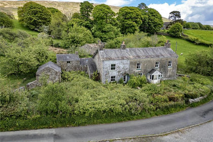
- Price
- Guide Price£480,000
- Size
- 16.63 acres
Added on 05/08/2026Agricultural Land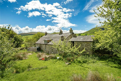
- Price
- Guide Price£350,000
- Size
- 16.63 acres
Added on 05/08/2026Agricultural Land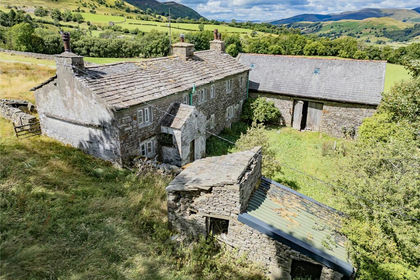
- Price
- Guide Price£385,000
- Size
- 29.45 acres
High House Farm, Gawthrop, Sedbergh, Cumbria, Dent, Westmorland and Furness LA10 England
Added on 05/08/2026Derelict property