Boylestone, Ashbourne
- Land size
- 3.15 acres
Key Features
- Rural development opportunity
- Class Q planning permission granted for the conversion of agricultural barns into 9 dwellings
- Atttractive red-brick losted farmhouse requiring modernisation
- Furhter planning application awaiting determination of selected agricultural barns and the erection of five new-build dwellings.
Description
- Rural development opportunity
- Class Q planning permission granted for the conversion of agricultural barns into 9 dwellings.
- Attractive listed red-brick farmhouse requiring modernisation.
- Further planning application currently awating determination of selected agricultrual barms and the erection of five new-build dwellings.
Location - Lees Hall Farm is located within the small village of Harehill, forming part of the civil parish of the sought-after village of Boylestone. The property enjoys a peaceful rural setting whilst remaining conveniently accessible to the nearby market towns of Ashbourne and Uttoxeter, lying approximately 7 miles south of Ashbourne and 10 miles north-west of Uttoxeter. The city of Derby is approximately 16 miles to the east, with these together providing an extensive range of amenities, schools and services.
The larger village of Boylestone, located approximately 1 mile to the south-east, offers a traditional rural community with local amenities nearby, whilst the surrounding area is predominantly agricultural in nature, characterised by rolling countryside, quiet country lanes, public footpaths and bridleways. Good road links are available via the A50 and A515, providing access to the wider Midlands road network.
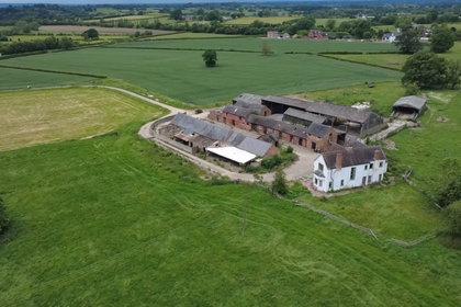
Description - An opportunity to acquire a rural residential development site extending to approximately 3.15 acres (1.27 hectares), comprising a Grade II listed red-brick farmhouse, a substantial range of traditional and modern farm buildings, and an associated yard area, situated in a rolling countryside location in South Derbyshire.
The site offers substantial development potential and benefits from Class Q planning approval for the conversion of existing agricultural buildings into residential units. In addition, a planning application has been submitted seeking consent for the demolition of the existing agricultural buildings and the construction of new residential dwellings.
Situated within open countryside yet conveniently located close to local services and transport links, the property occupies an attractive and accessible rural setting.
Planning Permission - Currently, the site benefits from Class Q planning permission to convert the existing agricultural buildings into 9 dwellings.
Planning Application References:
DMPN/2023/1324 (approval for conversion of into 5 dwellings)
DMPA/2024/1156 (aprpoval for conversion into 4 dwellings)
In addition, there is currently an application submitted to South Derbyshire Local Authority to demolish some of the existing agricultural buildings and built new build dwellings, which is currently awaiting decision:
DMPA/2025/1591 (Demolition of 2 existing agricultural buildings (one of which benefits from prior approval for residential conversion for 5 dwellings ref. DMPN/2023/1324), the change of use, conversion and extension of existing agricultural barns to up to 4 residential dwellings and erection of up to 5 new-build dwellings).
The Farmhouse - The farmhouse has a breadth of retained period features, and benefits from a kitchen, large walk in pantry, WC, storeroom, sitting room and dining room to the ground floor, two double bedrooms with ensuites, one single bedroom, main bathroom, with two further subtantial attic rooms and a third attic room which contains the water tank. The farmhouse has a Gross Internal Area of approximatly 3200 square feet.
Tenure - The property will be sold freehold with vacant possession.
Services - The property is connected to mains electricity, water, gas central heating and a private drainage system.
Viewing - Viewings to be by appointment only. Please contact Eloise Baker or Peter Chennells.
Land Registry - The site is registered with the Land Registry on the below title number:
DY230644 (Part Of)
Method Of Sale - The property is offered for sale via private treaty.
Rights Of Way, Wayleaves And Easements - The agent is not aware of any rights of way, wayleaves or easements. The Property is sold subject to and with the benefit of all rights of way, easements, wayleaves and other rights, whether mentioned in these particulars or not.
Local Planning Authority - The site lies within the South Derbyshire Local Authority.
Further Information - For any further information please contact Eloise Baker or Peter Chennells at the Andrew Granger Rural Office in Loughborough:
Peter Chennells
Tel:
E-mail: peter.
Eloise Baker
Tel:
E-mail: eloise.
Disclaimer - These particulars are intended as a guide only and do not form part of any contract. All descriptions, plans, dimensions and other details are given in good faith but should not be relied upon as statements of fact. Prospective purchasers must satisfy themselves as to their accuracy by inspection or otherwise. The Property is offered subject to contract, prior sale and withdrawal without notice.
Plan - The plan with red lines are based on Ordnance Survey data and provided for reference purposes only. The vendor not the Vendor's agent are responsible for defining the boundaries or the ownership.
Map Location
Property details
- Tenure
- Freehold
- Council Tax Band
- Ask Agent
- Date Posted
- 2026-08-11
Market Value Analysis
Compared with 128 Development Land listings in East Midlands (1+ acres).
Utilities & Restrictions
Utilities
- Electricity
- Ask Agent
- Water
- Ask Agent
- Heating
- Ask Agent
- Broadband
- Ask Agent
- Sewerage
- Ask Agent
Rights & Restrictions
- Public Rights of Way
- Ask Agent
- Private Rights of Way
- Ask Agent
- Listed Property
- Ask Agent
- Restrictions
- Ask Agent
Property Features
- Accessibility
- Ask Agent
- Parking
- Ask Agent
- Garden
- Garden
Connectivity
Broadband
Fastest speed available at this postcode
1.8 Gbps
Gigabit full fibre · available to 82% of premises
Suitable for
- 4K streaming on every screen
- Full-time home working
- Online gaming & big downloads
Mobile signal
Outdoor predictions; indoor signal depends on building materials.
Ofcom Connected Nations postcode-level predictions. Speeds and signal are modelled, not measured, and vary between addresses and providers.
Nearest Schools
Primary
- Church Broughton CofE Primary School2.2 milesNo Ofsted rating
- Ages
- 4 to 11
- Pupils
- 68
- Type
- Voluntary controlled school
- Faith
- Church of England
- Sudbury Primary School2.3 milesOfsted: Requires improvement
- Ages
- 3 to 11
- Type
- Academy converter
- Longford CofE Primary School3 milesNo Ofsted rating
- Ages
- 4 to 11
- Pupils
- 70
- Type
- Academy converter
- Faith
- Church of England
- Marston Montgomery Primary School3 milesOfsted: Requires improvement
- Ages
- 4 to 11
- Pupils
- 18
- Type
- Academy converter
- Doveridge Primary School3.5 milesNo Ofsted rating
- Ages
- 4 to 11
- Pupils
- 84
- Type
- Community school
Secondary
- The JCB Academy4.8 milesOfsted: Good
- Ages
- 13 to 19
- Pupils
- 781
- Type
- University technical college
- Ryecroft CofE Middle School5 milesNo Ofsted rating
- Ages
- 9 to 13
- Pupils
- 201
- Type
- Academy converter
- Faith
- Church of England
- Thomas Alleyne's High School5.2 milesNo Ofsted rating
- Ages
- 13 to 18
- Pupils
- 941
- Type
- Academy converter
- Windsor Park CE Middle School5.7 milesOfsted report card · Jun 2026
- Ages
- 9 to 13
- Pupils
- 345
- Type
- Academy converter
- Faith
- Church of England
- Oldfields Hall Middle School5.8 milesOfsted report card · Jun 2026
- Ages
- 9 to 13
- Pupils
- 527
- Type
- Academy converter
Distances are straight-line from the advertised location. Source: the national school registers (DfE, Welsh Government, Scottish Government) and Ofsted.
Amenities
Supermarket
GP surgery
Pharmacy
Hospital
Straight-line distances from the advertised location. Sources: NHS records, Geolytix supermarket locations, OS Open Greenspace and the national trails registers.
Getting Around
Nearest station
Nearest bus stop
Typical drive times
Straight-line distances from the advertised location; drive times are typical free-flow times over OpenStreetMap road data, so allow more at peak. Public transport locations from DfT NaPTAN.
Flood Risk
From Environment Agency flood map open data, checked around the advertised map pin and allowing for the listed acreage where known. This summary comes from LandSale, the advertising platform, not from the listing agent, and is not part of the agent's particulars. Risk can vary across a single holding, so verify anything critical through your own searches before committing.
Rivers and the sea
Surface water
The detail behind these bandings, including exact zones and annual chances, any recorded past flooding, plus planning, heritage, nature and ground checks, is in the .
Important notice: Information, maps and tags on this page are supplied by the advertising agent or generated automatically. LandSale has not verified them. Relying on these details is at your own risk, always carry out independent checks before committing to a purchase.
LandSale full disclaimer
Marketing information only - not formal particulars. The details on this website are provided for general guidance and do not constitute an offer or contract. Neither LandSale nor the advertising estate/land agent accepts responsibility for any inaccuracy.
1. Source of information
- Agent-supplied content: Core description, asking price, tenure, measurements, photographs and planning history are uploaded by the appointed agent, who remains solely responsible for their accuracy.
- Automated tags & categorisation: Property type, land-use class, acreage bands and similar labels may be applied by machine-learning models. They are intended as a helpful guide only and may not reflect the property's legal status or permitted use.
- Third-party & enriched data layers: Maps, boundary outlines, planning designations, soil reports, broadband coverage and other environmental or location-based insights are licensed from external suppliers. Such data are supplied “as is", may be incomplete or out of date and are subject to change without notice.
2. Verification required
Prospective purchasers must verify critical matters, including but not limited to planning permission, title boundaries, public rights of way, environmental constraints, acreage, services, access and VAT status, through their own inspections, specialist surveys, legal advisers and the selling agent before relying on the information or entering into any contract.
3. No warranty or liability
LandSale gives no warranty, express or implied, as to the accuracy, completeness or fitness for any particular purpose of the information displayed. LandSale shall not be liable for any loss, damage, cost or expense arising directly or indirectly from any use of or reliance on such information, save where liability may not be excluded by law.
4. Updates & feedback
If you believe any detail on this listing is inaccurate, please let us know. We will investigate and, where appropriate, update the listing or notify the agent.
© LandSale | Version 1.2 - January 2026
Listing agent
Andrew Granger & Co Rural, Land and Development, Loughborough
7-8 Bedford Square, Loughborough, LE11 2TP
Contact Andrew Granger & Co Rural, Land and Development, Loughborough
7-8 Bedford Square, Loughborough, LE11 2TP
View agent profileSimilar properties for sale
- Price
- Guide Price£1,150,000
- Size
- 2.8 acres
Added on 29/01/2026Development Land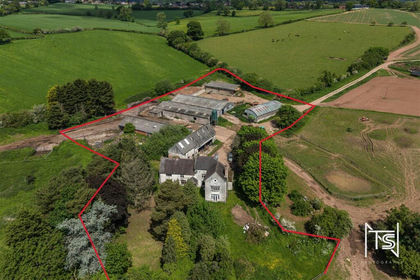
- Price
- Offers in Region of£1,300,000
- Size
- 1.79 acres
Jeffrey Meadows Farm, Nabb Lane, Alton, Alton, Staffordshire ST10 England
Added on 18/08/2026Development Land
- Price
- Offers in Region of£1,750,000
- Size
- 3 acres
Hopewell, Weston Underwood, Ashbourne, Derbyshire, Weston Underwood, Derbyshire DE6 England
Added on 30/04/2026Woodland with Cabin
- Price
- Guide Price£1,250,000
- Size
- 6.56 acres
Hall Farm (Development Site including House), Twyford, Twyford and Stenson, Derbyshire DE73 England
Added on 20/07/2026Development Land
- Price
- £1,750,000
- Size
- 3.3 acres
Ramsley Fields, Station Road, Melbourne, Melbourne, Derbyshire DE73 England
Added on 29/01/2026Development Land
- Price
- £1,250,000
- Size
- 1.54 acres
The Drill Hall, Derby Road, Clay Cross, East Midlands, Clay Cross, Derbyshire S45 England
Added on 29/01/2026Development Land
- Price
- Offers Over£1,300,000
- Size
- 3.5 acres
Station Lane, Glenfield, LE3, Leicester, Leicestershire LE3 England
Added on 08/08/2026Development Land
- Price
- Guide Price£1,150,000
- Size
- 53.58 acres
Added on 22/06/2026Farm
- Price
- £1,695,000
- Size
- 1.8 acres
Heybridge Lane, Prestbury, SK10, Prestbury, Cheshire East SK10 England
Added on 18/06/2026Development Land
- Price
- Guide Price£1,150,000
- Size
- 18 acres
Disley, Stockport, Cheshire, SK12, Disley, Cheshire East SK12 England
Added on 29/01/2026Agricultural Land