Harthill Field Road, Harthill, Sheffield, South Yorkshire, S26
- Land size
- 40.63 acres
Description
CLOSING DATE FOR OFFERS 5PM WEDNESDAY 5TH AUGUST
Location
Grange Farm occupies a private, rural, yet accessible location situated approximately 0.5 mile to the south-east of the desirable village of Harthill in the county of South Yorkshire.
The popular market town of Worksop is situated approximately 6.8 miles to the east whilst the city of Sheffield is situated approximately 13.9 miles to the north-west.
Access to the M1 motorway is available at junction 30 which is situated approximately 3.5 miles by road to the south-west.
Sheffield and Worksop offer a good range of schools in both the independent and state sectors together with a good range of shopping, amenities and professional services.
Mainline rail connections are available at Sheffield which connect with London Kings Cross in 2 hours.
Lot 1
Lot 1 comprises the farmstead which is centrally situated on the holding and includes the farmhouse, a range of traditional buildings arranged around a central courtyard, a range of general purpose buildings together with a ringfenced parcel of grassland extending in all, to approximately 40.63 acres (16.43 hectares).
The farmhouse is situated in the north-eastern
corner of the farmstead and is of stone construction with part rendered walls under a pitched pantile roof covering. The farmhouse provides approximately 2,450 ft² (227 m²) of generously proportioned and wellbalanced living accommodation which offers the purchaser an opportunity to modernise and adapt to suit their needs.
The accommodation comprises a breakfast kitchen, pantry, dining room, snug and sitting room to the ground floor with four bedrooms and house bathroom to the first floor.
Externally, there is an enclosed south-facing garden with ample parking to the northern elevation.
The farm buildings comprise a traditional range of stone buildings under a mixture of pantile and corrugated profile clad roofs all arranged around a central courtyard and offering potential for conversion subject to obtaining the necessary planning consents.
Situated to the west of the courtyard is a range of general purpose buildings providing livestock accommodation and storage for feedstuffs and machinery.
The farm buildings more specifically comprise:
A. Traditional Range (244 m²) – range of traditional single storey buildings of stone construction under steel profile roof sheet coverings and arranged around a central courtyard.
B. Granary (248 m²) – a single two storey traditional building of stone construction under a pitched pantile roof covering.
C. Byre (141 m²) – a traditional single storey building of stone construction under a part pantile and part corrugated profile clad roof covering.
D. Livestock accommodation (331 m²) – concrete portal framed building under a corrugated profile clad roof with block walls, external feed barrier and concrete floor.
E. General Purpose (439 m²) – concrete portal framed building with adjoining lean-to under a corrugated profile clad roof covering and cladding to eaves.
F. Livestock accommodation (354 m²) – concrete portal framed building under a pitched corrugated profile clad roof with corrugated profile clad sheets to eaves.
G. Byre (126 m²) – traditional building of stone wall construction under a pitched corrugated clad roof covering.
The land included with Lot 1 extends in all to approximately 40.63 acres (16.43 hectares) of productive grassland currently subdivided into paddocks and utilised for a mixture of equestrian turnout and livestock grazing.
The land situated to the south of the farmstead benefits from a central access track providing convenient access to the paddocks with the main farm access track dissecting the land to the north of the farmstead.
The land is bounded by timber post and wire fencing providing livestock proof boundaries.
Method of Sale
The property is offered for sale by private treaty as Lot 1 of two lots. The vendors reserve the right to conclude the sale by any other means at their discretion.
If you have downloaded these particulars, please register your interest with the selling agent
Tenure & Possession
The property is offered for sale freehold with vacant possession available on completion.
Basic Payment Scheme
The land has been registered on the Rural Land Register and all de-linked payments will be retained by the vendor.
Designations
Grange Farm is situated within a Nitrate Vulnerable Zone (NVZ).
Ingoing Valuation and Holdover
In the event that the sale completes after the 2026 harvest, the purchaser(s) will be obliged to take over and pay for all growing crops, including cultivations, seeds, fertilisers, sprays, lime, new leys and acts of husbandry at cost or market value (whichever is higher) where applicable.
Services
Grange Farm benefits from connections to mains water and electricity. Drainage is to a private septic tank. Heating and hot water is provided by an LPG-fired boiler.
Wayleaves, Easements, & Rights of Way
The land is sold subject to and with the benefits of all rights of way, water drainage, water courses and other easements quasi or reputed easements and rights of adjoining owners (if any) affecting the same and all existing and proposed wayleaves and other matters registered by any competent authority subject to statute.
Health & Safety
Please take care when viewing the property and be as vigilant as possible when making an inspection for your own personal safety.
VAT
Any prices quoted are exclusive of VAT. Should the property, any part of it or right attached become chargeable supply for VAT, such tax will be payable in addition to the purchase price.
Sporting Rights
The sporting rights are included with the sale insofar as they are owned.
Mineral Rights
The mineral rights are reserved to a third party and are therefore, excluded from the sale.
EPC Ratings
Current: G(16)
Potential: D(62)
Local Authority
Rotherham Metropolitan Borough Council
Viewings
Viewings are strictly by appointment only through the selling agent.
Directions
Exit the M1 at Junction 30 then take the exit for the A619 signposted Worksop. At the next roundabout take the first exit and continue for approximately 2.4 miles before turning left onto Gapstick Lane (signposted Harthill). After approximately 1 mile turn left onto Bondhay Lane. Continue for approximately 1 mile and Grange Farm is situated on the left hand side.
Postcode: S26 7XS
What3Words
/// ambushes.spouting.track
Map Location
Property details
- Tenure
- Freehold
- Council Tax Band
- TBC
- Date Posted
- 2026-07-05
Market Value Analysis
Compared with 22 Farms & Smallholdings listings in Yorkshire and The Humber (25+ acres).
Utilities & Restrictions
Utilities
- Electricity
- Ask Agent
- Water
- Ask Agent
- Heating
- Ask Agent
- Broadband
- Ask Agent
- Sewerage
- Ask Agent
Rights & Restrictions
- Public Rights of Way
- Ask Agent
- Private Rights of Way
- Ask Agent
- Listed Property
- Ask Agent
- Restrictions
- Ask Agent
Listed status, conservation areas and planning constraints for this location are in the full report.
Property Features
- Accessibility
- Ask Agent
- Parking
- Parking Available
- Garden
- Garden
Beyond the particulars: planning activity, flood history, heritage and ground risks, checked for this exact spot.
Connectivity
Broadband
Fastest speed available at this postcode
2 Mbps
Under 10 Mbps here
Suitable for
- Basic browsing & email
Mobile signal
Predicted 4G and 5G signal; indoor signal depends on building materials.
Ofcom Connected Nations postcode-level predictions. Speeds and signal are modelled, not measured, and vary between addresses and providers.
Signal is the easy part. Planning activity, flood history and protected designations here are in the full report.
Nearest Schools
Primary
- Harthill Primary School0.9 milesOfsted: Good *
- Ages
- 5 to 11
- Pupils
- 149
- Type
- Academy converter
- Barlborough Primary School2 milesOfsted: Requires improvement *
- Ages
- 4 to 11
- Pupils
- 191
- Type
- Community school
- Clowne Infant and Nursery School2.5 milesOfsted: Good
- Ages
- 3 to 7
- Pupils
- 318
- Type
- Community school
- Kiveton Park Infant School2.5 milesOfsted: Good
- Ages
- 3 to 7
- Pupils
- 158
- Type
- Academy converter
- Clowne Junior School2.5 milesOfsted: Good
- Ages
- 7 to 11
- Pupils
- 326
- Type
- Community school
Secondary
- Heritage High School2.3 milesOfsted: Good
- Ages
- 11 to 16
- Pupils
- 940
- Type
- Academy sponsor led
- Wales High School2.7 milesNo Ofsted rating
- Ages
- 11 to 18
- Pupils
- 1,783
- Type
- Academy converter
- Westfield School4.4 milesOfsted report card · Jan 2026
- Ages
- 11 to 16
- Pupils
- 1,366
- Type
- Academy sponsor led
- Netherthorpe School4.8 milesOfsted: Inadequate *
- Ages
- 11 to 18
- Pupils
- 973
- Type
- Academy converter
- Dinnington High School4.9 milesOfsted: Requires improvement
- Ages
- 11 to 18
- Pupils
- 1,005
- Type
- Academy converter
* Latest graded judgement covers quality of education only; no overall grade was issued under the 2024-25 inspection framework.
Distances are straight-line from the advertised location. Source: the national school registers (DfE, Welsh Government, Scottish Government) and Ofsted.
Schools are just the start: sold prices nearby, planning activity and any flood history are in the full report.
Amenities
Supermarket
GP surgery
Pharmacy
Hospital
Straight-line distances from the advertised location. Sources: NHS records, Geolytix supermarket locations, OS Open Greenspace and the national trails registers.
The area stacks up? Now check the location itself: planning nearby, protected designations and past flooding.
Getting Around
Nearest station
Nearest bus stop
Typical drive times
Straight-line distances from the advertised location; drive times are typical free-flow times over OpenStreetMap road data, so allow more at peak. Public transport locations from DfT NaPTAN.
Easy to reach matters. So do planning activity, flood history and ground risks: all in the full report.
Flood Risk
Environment Agency open data, checked around the advertised map pin for the listed acreage. Long-term risk counts flood defences; the planning map's flood zones do not. Provided by LandSale, not the listing agent, and not part of the agent's particulars. Risk varies across a holding, so verify before committing.
Rivers and the sea
Planning map: Flood Zone 1.
Surface water
Not at the pin: mapped about 50 metres away.
These bandings are the summary. Where this location sits on the flood maps, plus planning activity, heritage and ground risks, is in the full report.
Important notice: Information, maps and tags on this page are drawn from the advertising agent's marketing materials or generated automatically. LandSale has not verified them. Relying on these details is at your own risk, always carry out independent checks before committing to a purchase.
LandSale full disclaimer
Marketing information only - not formal particulars. The details on this website are provided for general guidance and do not constitute an offer or contract. Neither LandSale nor the advertising estate/land agent accepts responsibility for any inaccuracy.
1. Source of information
- Listing content: Core description, asking price, tenure, measurements, photographs and planning history originate from the marketing materials of the advertising estate or land agent. LandSale does not author this content and cannot guarantee its accuracy.
- Automated tags & categorisation: Property type, land-use class, acreage bands and similar labels may be applied by machine-learning models. They are intended as a helpful guide only and may not reflect the property's legal status or permitted use.
- Third-party & enriched data layers: Maps, boundary outlines, planning designations, soil reports, broadband coverage and other environmental or location-based insights are licensed from external suppliers. Such data are supplied “as is", may be incomplete or out of date and are subject to change without notice.
2. Verification required
Prospective purchasers must verify critical matters, including but not limited to planning permission, title boundaries, public rights of way, environmental constraints, acreage, services, access and VAT status, through their own inspections, specialist surveys, legal advisers and the selling agent before relying on the information or entering into any contract.
3. No warranty or liability
LandSale gives no warranty, express or implied, as to the accuracy, completeness or fitness for any particular purpose of the information displayed. LandSale shall not be liable for any loss, damage, cost or expense arising directly or indirectly from any use of or reliance on such information, save where liability may not be excluded by law.
4. Updates & feedback
If you believe any detail on this listing is inaccurate, please let us know. We will investigate and, where appropriate, update the listing or notify the agent.
© LandSale | Version 1.3 - August 2026
Similar properties for sale
- Price
- Guide Price£995,000
- Size
- 116.99 acres
Added on 08/08/2026Agricultural Land
- Price
- Offers in Excess of£950,000
- Size
- 84.82 acres
Higher Chisworth, Chisworth, Glossop, Chisworth, Derbyshire SK13 England
Added on 08/07/2026Farm
- Price
- Offers in Excess of£1,000,000
- Size
- 20.24 acres
Heaton, Rushton Spencer, Macclesfield, SK11, Heaton, Staffordshire SK11 England
Added on 02/08/2026Smallholding
- Price
- Guide Price£1,000,000
- Size
- 32 acres
Wymeswold Road, Hoton, Loughborough, Hoton, Leicestershire LE12 England
Added on 18/09/2026Smallholding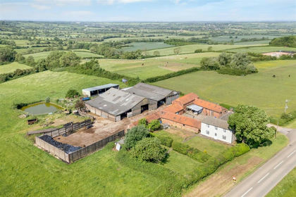
- Price
- Guide Price£1,500,000
- Size
- 98.77 acres
Lodge Farm, Melton Road, Long Clawson, Melton Mowbray LE14, Ab Kettleby, Leicestershire LE14 England
Added on 23/09/2026Farm