Chart Lane, Brasted Chart, Westerham, TN16
- Land size
- 1 acres
- Bedrooms
- 5
- Bathrooms
- 4
Key Features
- Fine detached country house on the edge of The Chart
- Lovely views south over adjoining countryside
- Bright and airy accommodation extending to 3722 square feet
- Colourful gardens of approximatley an acre
- Just under a mile of Brasted village
- Please note photos depict furnishings from a previous occupant.
Description
Within a National Landscape, yet less than a mile from the charming village of Brasted, a handsome, detached house of character enjoying fine views to the rear over local woodland. Possibly originally dating from the 1920s/30s and set back from the lane, the house is approached via a carriage driveway and has external elevations of painted render with tile hanging and double-glazed leaded light windows, under a pitched tiled roof, while internally the property retains some period features such as oak windowsills and some decorative oak beams but in general has been updated and reimagined to create a modern family home. There are wooden floors throughout the ground floor, except for the carpeting in the drawing room and tiles in the kitchen/breakfast/dining room, whilst the large windows or French doors allow for an abundance of natural light and views of the gardens and beyond. There are three gracious reception rooms, including the drawing room, which enjoys a triple aspect and an open fire with timber surround and stone hearth. The kitchen/breakfast/dining room is a wonderfully bright and airy, open plan living space, comprehensively furnished with wooden cabinetry and granite work surfaces by Mark Wilkinson and integrated appliances including a range cooker by Falcon. From the kitchen, a door leads though to the garage where there is also a utility/laundry area. Elsewhere there are stairs up to the guest suite/studio where there is also an en-suite shower room – making an ideal au-pair/relative suite or a gym. The first floor is given over to four good size bedrooms – all enjoying the views - supported by three bath/shower rooms, two of which are en-suite, including the principal suite, which also has a fitted dressing area.
Outside
The property is approached via a carriage driveway and is surrounded by colourful, well-established gardens. There are tall, mature trees and hedges, rhododendrons, azaleas and acres, well-stocked herbaceous borders and large swathes of lush lawn and an excellent tennis court has recently been re surfaced. The double garage is integral to the house.
Situation
Situated in a peaceful, yet highly convenient, semi-rural location within the Kent Downs Area of Outstanding Natural Beauty, yet only 0.8 miles from the historic village of Brasted with its village store, pub, café and interiors boutiques. Toys Hill and the surrounding Chart, comprising some 200 acres of National Trust owned woodland dotted with established foot and bridle paths, is a popular choice for hikers, cyclists and riders alike
Nearby Sevenoaks boasts a theatre, comprehensive selection of shops, restaurants and supermarkets including Waitrose and M&S together with sporting facilities including a leisure centre, golf at Westerham, Knole and Wildernesse, as well as various football, rugby, cricket and tennis clubs. Road and rail communications links are excellent with trains from Sevenoaks station offering excellent and speedy connections to London and connections to the national motorway network and airports via the A21 and M25 J5.
The Sevenoaks area is renowned for the excellent schooling available at primary and secondary levels, in both the state and primary sectors, including primary schools in Westerham and Sundridge & Brasted, grammar schools in Orpington, Sevenoaks, Tonbridge and Tunbridge Wells, together with independent schools such as Sevenoaks and Tonbridge public schools, Walthamstow Hall, The New Beacon, Radnor House and Sevenoaks Prep.
Property Ref Number:
HAM-39615Additional Information
Services: Main electricty, water; oil central heating and hot water
Tenure: Freehold
Local Authority: Sevenoaks District Council;
Tax Band H
Please note photos depict furnishings from a previous occupant.
Map Location
Property details
- Tenure
- Freehold
- Council Tax Band
- H
- Date Posted
- 2026-07-03
Market Value Analysis
Compared with 1,865 Homes with Land listings in South East England (1+ acres).
Energy Performance Certificate
Energy Efficiency Rating
Based on UK Energy Performance Certificate standards (EU Directive 2002/91/EC)
Utilities & Restrictions
Utilities
- Electricity
- Ask Agent
- Water
- Ask Agent
- Heating
- Ask Agent
- Broadband
- Ask Agent
- Sewerage
- Ask Agent
Rights & Restrictions
- Public Rights of Way
- Ask Agent
- Private Rights of Way
- Ask Agent
- Listed Property
- Ask Agent
- Restrictions
- Ask Agent
Property Features
- Accessibility
- Ask Agent
- Parking
- Parking Available
- Garden
- Patio, Private Garden
Connectivity
Broadband
Fastest speed available at this postcode
1.8 Gbps
Gigabit full fibre
Suitable for
- 4K streaming on every screen
- Full-time home working
- Online gaming & big downloads
Mobile signal
Outdoor predictions; indoor signal depends on building materials.
Ofcom Connected Nations postcode-level predictions. Speeds and signal are modelled, not measured, and vary between addresses and providers.
Nearest Schools
Primary
- Sundridge and Brasted Church of England Voluntary Controlled Primary School1.3 milesOfsted: Good
- Ages
- 4 to 11
- Pupils
- 78
- Type
- Voluntary controlled school
- Faith
- Church of England
- Ide Hill Church of England Primary School1.4 milesNo Ofsted rating
- Ages
- 4 to 11
- Pupils
- 154
- Type
- Voluntary aided school
- Faith
- Church of England
- Churchill Church of England Voluntary Controlled Primary School1.6 milesOfsted: Good *
- Ages
- 5 to 11
- Pupils
- 203
- Type
- Voluntary controlled school
- Faith
- Church of England
- Crockham Hill Church of England Voluntary Controlled Primary School2.4 milesNo Ofsted rating
- Ages
- 4 to 11
- Pupils
- 142
- Type
- Voluntary controlled school
- Faith
- Church of England
- Chevening, St Botolph's Church of England Voluntary Aided Primary School2.5 milesOfsted: Good
- Ages
- 5 to 11
- Pupils
- 196
- Type
- Voluntary aided school
- Faith
- Church of England
Secondary
- Knole Academy3.9 milesNo Ofsted rating
- Ages
- 11 to 19
- Pupils
- 1,410
- Type
- Academy sponsor led
- Charles Darwin School4.4 milesOfsted: Good
- Ages
- 11 to 18
- Pupils
- 1,305
- Type
- Academy converter
- Oxted School4.6 milesOfsted report card · Mar 2026
- Ages
- 11 to 18
- Pupils
- 1,528
- Type
- Academy converter
- Trinity School4.8 milesNo Ofsted rating
- Ages
- 11 to 19
- Pupils
- 1,153
- Type
- Free schools
- Faith
- Christian
- Meridian High School6.7 milesOfsted: Good
- Ages
- 11 to 18
- Pupils
- 535
- Type
- Academy sponsor led
* Latest graded judgement covers quality of education only; no overall grade was issued under the 2024-25 inspection framework.
Distances are straight-line from the advertised location. Source: the national school registers (DfE, Welsh Government, Scottish Government) and Ofsted.
Amenities
Supermarket
GP surgery
Pharmacy
Hospital
Green space
Straight-line distances from the advertised location. Sources: NHS records, Geolytix supermarket locations, OS Open Greenspace and the national trails registers.
Getting Around
Nearest station
Nearest bus stop
Typical drive times
Straight-line distances from the advertised location; drive times are typical free-flow times over OpenStreetMap road data, so allow more at peak. Public transport locations from DfT NaPTAN.
Flood Risk
From Environment Agency flood map open data, checked around the advertised map pin and allowing for the listed acreage where known. This summary comes from LandSale, the advertising platform, not from the listing agent, and is not part of the agent's particulars. Risk can vary across a single holding, so verify anything critical through your own searches before committing.
Rivers and the sea
Surface water
The detail behind these bandings, including exact zones and annual chances, any recorded past flooding, plus planning, heritage, nature and ground checks, is in the .
Important notice: Information, maps and tags on this page are supplied by the advertising agent or generated automatically. LandSale has not verified them. Relying on these details is at your own risk, always carry out independent checks before committing to a purchase.
LandSale full disclaimer
Marketing information only - not formal particulars. The details on this website are provided for general guidance and do not constitute an offer or contract. Neither LandSale nor the advertising estate/land agent accepts responsibility for any inaccuracy.
1. Source of information
- Agent-supplied content: Core description, asking price, tenure, measurements, photographs and planning history are uploaded by the appointed agent, who remains solely responsible for their accuracy.
- Automated tags & categorisation: Property type, land-use class, acreage bands and similar labels may be applied by machine-learning models. They are intended as a helpful guide only and may not reflect the property's legal status or permitted use.
- Third-party & enriched data layers: Maps, boundary outlines, planning designations, soil reports, broadband coverage and other environmental or location-based insights are licensed from external suppliers. Such data are supplied “as is", may be incomplete or out of date and are subject to change without notice.
2. Verification required
Prospective purchasers must verify critical matters, including but not limited to planning permission, title boundaries, public rights of way, environmental constraints, acreage, services, access and VAT status, through their own inspections, specialist surveys, legal advisers and the selling agent before relying on the information or entering into any contract.
3. No warranty or liability
LandSale gives no warranty, express or implied, as to the accuracy, completeness or fitness for any particular purpose of the information displayed. LandSale shall not be liable for any loss, damage, cost or expense arising directly or indirectly from any use of or reliance on such information, save where liability may not be excluded by law.
4. Updates & feedback
If you believe any detail on this listing is inaccurate, please let us know. We will investigate and, where appropriate, update the listing or notify the agent.
© LandSale | Version 1.2 - January 2026
Listing agent
Hamptons, Sevenoaks
24 London Road, Sevenoaks, TN13 1AP
Similar properties for sale

- Price
- Guide Price£1,500,000
- Size
- 2 acres
Scords Lane, Toys Hill - with 1.5 acres, Brasted, Kent TN16 England
Added on 04/08/2026House with Land
- Price
- Offers in Excess of£1,500,000
- Size
- 1 acres
Added on 19/04/2026House with Land
- Price
- Guide Price£2,000,000
- Size
- 1.27 acres
Farley Lane, Westerham, Kent, TN16, Westerham, Kent TN16 England
Added on 12/03/2026House with Land
- Price
- £1,595,000
- Size
- 1 acres
Added on 25/07/2026House with Land
- Price
- Guide Price£1,850,000
- Size
- 1.22 acres
Goodley Stock Road, Crockham Hill, Kent, TN8, Westerham, Kent TN8 England
Added on 29/01/2026House with Land
- Price
- Guide Price£2,500,000
- Size
- 5 acres
Silverstead Lane, Westerham, Orpington, Bromley TN16 England
Added on 04/07/2026House with Land
- Price
- £2,250,000
- Size
- 1 acres
Added on 26/06/2026Barn Conversion
- Price
- Offers Over£1,750,000
- Size
- 5 acres
Wickhurst Road, Weald, Sevenoaks, Kent, TN14, Sevenoaks Weald, Kent TN14 England
Added on 21/05/2026House with Land
- Price
- Guide Price£1,650,000
- Size
- 1.1 acres
Itchingwood Common Road, Limpsfield, Oxted, Surrey, RH8, Limpsfield, Surrey RH8 England
Added on 23/04/2026Farmhouse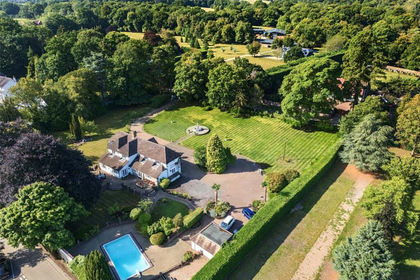
- Price
- Guide Price£2,250,000
- Size
- 1.8 acres
Rushmore Hill, Knockholt, Sevenoaks, Knockholt, Kent TN14 England
Added on 01/07/2026House with Land