Hinton Hill, Crewkerne, TA18
- Land size
- 1.73 acres
Key Features
- 1.73 Acres of permanent pasture land
- Scenic position in open countryside
- Road access
- Grade III on Provisional Agricultural Land Classification
Description
An exciting opportunity to acquire an attractive parcel of pasture land, tucked away along a quiet rural lane, offering purchasers the chance to own their own part of the Somerset countryside. The land extends to approximately 1.73 acres (0.70 hectares).
An adjacent parcel of land is also available as a separate Lot.
For Sale by In-Room and Livestream Auction on Wednesday 15th July 2026 at 2:00pm at The Shrubbery Hotel, Ilminster, Somerset, TA19 9AR
The land comprises two parcels of level to gently sloping amenity land extending in total to approximately 2.05 acres (0.83 hectares). The land it to be sold in two separate lots and is further described below.
LOT 1 - 1.73 acres of pasture land (shaded pink on the attached site plan)
This attractive parcel of land extends to approximately 1.73 acres (0.70 hectares) of gently undulating, permanent pasture, offering a charming rural setting. The land is enclosed by mature hedgerows, and does not benefit from any water services. The land is accessed directly off the public highway known as Hinton Road onto Crow Castle Lane.
LOT 2 - 0.32 acres of woodland (shaded blue on the attached site plan)
This appealing parcel extends to approximately 0.32 acres (0.13 hectares) of predominantly level to gently sloping land, characterised by areas of light, open woodland. The land is enclosed by mature trees and predominately undefined boundaries. This land does not benefit from any mains water services. On the land there is evidence of historic pig shelters, these would remain in situ at the time of sale. The land is accessed directly off the public highway known as Hinton Road onto Crow Castle Lane.
The land off Hinton Hill is situated in a tranquil rural position, to the north west of the busy county town of Crewkerne, offering an extensive range of local amenities and services, including supermarkets, schools, medical facilities, and a variety of recreational opportunities. The property benefits from good access, with the town of Crewkerne positioned at a three road junction providing connections to the A30, A356, and the B3165. The A30 serves as the main east–west corridor, while the A356 links northwards to the A303 and south into Dorset, making Crewkerne a small but important transport node within south Somerset, supporting wider regional travel.
Map Location
Property details
- Tenure
- Ask Agent
- Council Tax Band
- TBC
- Date Posted
- 2026-06-12
Market Value Analysis
Compared with 180 Farmland & Pasture listings in South West England (1+ acres).
Utilities & Restrictions
Utilities
- Electricity
- Ask Agent
- Water
- Ask Agent
- Heating
- Ask Agent
- Broadband
- Ask Agent
- Sewerage
- Ask Agent
Rights & Restrictions
- Public Rights of Way
- Ask Agent
- Private Rights of Way
- Ask Agent
- Listed Property
- Ask Agent
- Restrictions
- Ask Agent
Property Features
- Accessibility
- Ask Agent
- Parking
- Ask Agent
- Garden
- Garden
Important notice: Information, maps and tags on this page are supplied by the advertising agent or generated automatically. LandSale has not verified them. Relying on these details is at your own risk, always carry out independent checks before committing to a purchase.
LandSale full disclaimer
Marketing information only - not formal particulars. The details on this website are provided for general guidance and do not constitute an offer or contract. Neither LandSale nor the advertising estate/land agent accepts responsibility for any inaccuracy.
1. Source of information
- Agent-supplied content: Core description, asking price, tenure, measurements, photographs and planning history are uploaded by the appointed agent, who remains solely responsible for their accuracy.
- Automated tags & categorisation: Property type, land-use class, acreage bands and similar labels may be applied by machine-learning models. They are intended as a helpful guide only and may not reflect the property's legal status or permitted use.
- Third-party & enriched data layers: Maps, boundary outlines, planning designations, soil reports, broadband coverage and other environmental or location-based insights are licensed from external suppliers. Such data are supplied “as is", may be incomplete or out of date and are subject to change without notice.
2. Verification required
Prospective purchasers must verify critical matters, including but not limited to planning permission, title boundaries, public rights of way, environmental constraints, acreage, services, access and VAT status, through their own inspections, specialist surveys, legal advisers and the selling agent before relying on the information or entering into any contract.
3. No warranty or liability
LandSale gives no warranty, express or implied, as to the accuracy, completeness or fitness for any particular purpose of the information displayed. LandSale shall not be liable for any loss, damage, cost or expense arising directly or indirectly from any use of or reliance on such information, save where liability may not be excluded by law.
4. Updates & feedback
If you believe any detail on this listing is inaccurate, please let us know. We will investigate and, where appropriate, update the listing or notify the agent.
© LandSale | Version 1.2 - January 2026
Similar properties for sale

- Price
- Guide Price£40,000
- Size
- 1.94 acres
Land At Vardens Farm, Broadway, Ilminster, Somerset, TA19, Broadway, Somerset TA19 9FQ England
Added on 14/07/2026Pasture
- Price
- Guide Price£45,000
- Size
- 15.52 acres
Taunton, Somerset, TA6, North Curry, Somerset TA3 6LB England
Added on 24/07/2026Pasture
- Price
- Guide Price£45,000
- Size
- 5.56 acres
Upottery, Honiton, Devon, EX14, Upottery, Devon EX14 9NZ England
Added on 25/07/2026Agricultural Land
- Price
- Guide Price£40,000
- Size
- 2.65 acres
Awliscombe, Honiton, Devon, EX14, Awliscombe, Devon EX14 3PS England
Added on 24/06/2026Agricultural Land
- Price
- Guide Price£40,000
- Size
- 3.63 acres
Awliscombe, Honiton, Devon, EX14, Awliscombe, Devon EX14 3PS England
Added on 24/06/2026Agricultural Land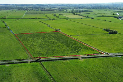
- Price
- Guide Price£35,000
- Size
- 8.41 acres
Added on 17/07/2026Vacant Land
- Price
- Guide Price£35,000
- Size
- 4.13 acres
Hackmead Lane, East Huntspill, Highbridge, Somerset, TA9, East Huntspill, Somerset TA9 3PS England
Added on 16/04/2026Pasture
- Price
- Guide Price£30,000
- Size
- 6.53 acres
Holford, Bridgwater, Somerset, TA5, Holford, Somerset TA5 1RY England
Added on 10/05/2026Undeveloped Land
- Price
- Guide Price£20,000
- Size
- 0.23 acres
Silver Street, Congresbury, BS49, Congresbury, North Somerset BS49 5DN England
Added on 25/06/2026Small Plot of Land