Craignich, Lismore, Oban, Argyll and Bute, PA34
- Land size
- 56.9 acres
- Bedrooms
- 4
- Bathrooms
- 2
Description
An opportunity to acquire a wonderful detached family home, set within a 56-acre croft on the ever-popular Isle of Lismore
A rare chance to embrace a unique lifestyle awaits with this family-owned croft and de-crofted house and garden ground, in all extending to approximately 23.038 hectares (56.9 acres) on the picturesque Isle of Lismore.
The Residence
The detached family home is accessed via an entrance porch, equipped with storm doors, leading into a generous central hallway. To the left the heart of the house is a spacious, open-plan living area, comprising kitchen, dining and sitting room, ideal for hosting family gatherings or relaxing in comfort.
At the south-facing gable end, a striking double-height garden room or “conservatory” offers a tranquil retreat with panoramic views over the croft and surrounding countryside. A first floor gallery overlooks this space, enhancing the sense of openness and connection with the landscape.
To the right of the hallway, a versatile workroom is well-lit by dual aspect windows, currently used as a home office, but equally well-suited as a study, studio or additional, ground-floor, bedroom. A pantry/store room and a utility room is also accessed from the hallway, along with a separate w.c., and a boot room and secondary entrance to the rear.
Upstairs, the spacious first-floor landing is flooded with natural light from a combination of five Velux roof windows. This space leads to three well-proportioned bedrooms. The principal bedroom features an en-suite shower room, with w.c and wash basin, and direct access to the conservatory gallery, providing extensive views of the croft. A family bathroom is also accessed from the landing, serving the remaining bedrooms.
The Croft
The croft itself spans both sides of the island road (the U50) and boasts a strong history of quality livestock production. Separate grazing paddocks have been supplied with livestock drinking troughs, fed from the private water supply.
A substantial agricultural shed provides ample dry storage and shelter for animals and benefits from the installation of a sheep-handling fank and cattle penning.
Adjacent to the home, a dedicated area has been cultivated for home-grown produce - an enclosed garden that perfectly complements the crofting lifestyle.
4 Craignich is located centrally on the Scottish Isle of Lismore, a fertile and historically significant limestone island which has supported a population since neolithic times. This magical island is one of the least explored of the Inner Hebrides.
Lismore has a well-respected primary school, public hall, general store and post office, and a heritage centre with museum and cafe. The island has a thriving resident community, situated, as it is, a short distance from the mainland at Port Appin, and accessed via a frequent foot passenger ferry. Alternatively, a vehicular ferry provides a daily timetabled service from Oban to the Lismore settlement of Achnacroish (about a mile from Craignich).
Specifications for the property include private water supply and drainage, an oil-fired Aga cooker with water heating, a multi-fuel stove and a mechanical ventilation system with heat-recovery.
Additional Information
Interested parties are advised to consult a solicitor with expertise in Crofting Law. Further details are available on the Crofting Register under reference C10031.
The croft itself spans both sides of the island road and boasts a strong history of quality livestock production.
A substantial agricultural shed provides ample dry storage and shelter for animals, benefitting from the installation of a sheep fank.
Adjacent to the home, a dedicated area has been cultivated for home-grown produce—an enclosed garden that perfectly complements the crofting lifestyle.
If travelling to the island from Oban, upon arriving at Achnacroish, follow the road out of the village and continue for approximately 0.8 miles until it meets the B8045. Turn left and proceed for around 450 yards, where you will see a right-hand turning. Take this turn and continue for about 300 yards; the property is located on the left-hand side. Parking is available to the front of the house.
Map Location
Property details
- Tenure
- Freehold
- Council Tax Band
- E
- Date Posted
- 2026-06-12
Market Value Analysis
Compared with 35 Farms & Smallholdings listings in Scotland (50+ acres).
Energy Performance Certificate
Energy Efficiency Rating
Based on UK Energy Performance Certificate standards (EU Directive 2002/91/EC)
Running costs are one side. Planning activity, flood history and ground risks for this location are in the full report.
Utilities & Restrictions
Utilities
- Electricity
- Ask Agent
- Water
- Ask Agent
- Heating
- Ask Agent
- Broadband
- Ask Agent
- Sewerage
- Ask Agent
Rights & Restrictions
- Public Rights of Way
- Ask Agent
- Private Rights of Way
- Ask Agent
- Listed Property
- Ask Agent
- Restrictions
- Ask Agent
Listed status, conservation areas and planning constraints for this location are in the full report.
Property Features
- Accessibility
- Ask Agent
- Parking
- Parking Available
- Garden
- Garden
Beyond the particulars: planning activity, flood history, heritage and ground risks, checked for this exact spot.
Connectivity
Broadband
Fastest speed available at this postcode
1.8 Gbps
Gigabit full fibre · available to 92% of premises
Suitable for
- 4K streaming on every screen
- Full-time home working
- Online gaming & big downloads
Mobile signal
Outdoor predictions; indoor signal depends on building materials.
Ofcom Connected Nations postcode-level predictions. Speeds and signal are modelled, not measured, and vary between addresses and providers.
Signal is the easy part. Planning activity, flood history and protected designations here are in the full report.
Nearest Schools
Primary
- Lismore Primary School0.9 miles
- Pupils
- 6
- Type
- Non-denominational
- Lochnell Primary School4.6 miles
- Pupils
- 118
- Type
- Non-denominational
- Dunbeg Primary School5.4 miles
- Pupils
- 94
- Type
- Non-denominational
- Park Primary School6.2 miles
- Pupils
- 216
- Type
- Non-denominational
- Strath of Appin Primary School Gaelic Medium7.1 miles
- Pupils
- 14
- Type
- Non-denominational
Secondary
- Oban High School7.5 miles
- Pupils
- 1,009
- Type
- Non-denominational
- Ardnamurchan High School13 miles
- Pupils
- 126
- Type
- Non-denominational
- Tobermory High School22 miles
- Pupils
- 151
- Type
- Non-denominational
- Kinlochleven High School25 miles
- Pupils
- 135
- Type
- Non-denominational
- Lochaber High School28 miles
- Pupils
- 839
- Type
- Non-denominational
Distances are straight-line from the advertised location. Source: the national school registers (DfE, Welsh Government, Scottish Government) and Ofsted.
Schools are just the start: planning activity, heritage and any flood history here are in the full report.
Amenities
Supermarket
GP surgery
Pharmacy
Walking trail
Straight-line distances from the advertised location. Sources: NHS records, Geolytix supermarket locations, OS Open Greenspace and the national trails registers.
The area stacks up? Now check the location itself: planning nearby, protected designations and past flooding.
Getting Around
Nearest station
Nearest bus stop
Typical drive times
Straight-line distances from the advertised location; drive times are typical free-flow times over OpenStreetMap road data, so allow more at peak. Public transport locations from DfT NaPTAN.
Easy to reach matters. So do planning activity, flood history and ground risks: all in the full report.
Flood Risk
From SEPA flood map open data, checked around the advertised map pin and allowing for the listed acreage where known. This summary comes from LandSale, the advertising platform, not from the listing agent, and is not part of the agent's particulars. Risk can vary across a single holding, so verify anything critical through your own searches before committing.
Rivers and the sea
Surface water
Mapped within the area searched, not at the advertised map pin itself.
The detail behind these bandings
The full report pinpoints where this location sits on the flood maps, and runs the deeper checks that usually only surface after an offer.
- Exact flood zones & annual chances (included in the full report)
- Any recorded past flooding (included in the full report)
- Planning activity nearby (included in the full report)
- Heritage & conservation (included in the full report)
- Protected nature designations (included in the full report)
- Ground risks (included in the full report)
£14.99 · one-off purchase
By LandSale, the platform. Not provided by the listing agent. Ready in about a minute.
Important notice: Information, maps and tags on this page are drawn from the advertising agent's marketing materials or generated automatically. LandSale has not verified them. Relying on these details is at your own risk, always carry out independent checks before committing to a purchase.
LandSale full disclaimer
Marketing information only - not formal particulars. The details on this website are provided for general guidance and do not constitute an offer or contract. Neither LandSale nor the advertising estate/land agent accepts responsibility for any inaccuracy.
1. Source of information
- Listing content: Core description, asking price, tenure, measurements, photographs and planning history originate from the marketing materials of the advertising estate or land agent. LandSale does not author this content and cannot guarantee its accuracy.
- Automated tags & categorisation: Property type, land-use class, acreage bands and similar labels may be applied by machine-learning models. They are intended as a helpful guide only and may not reflect the property's legal status or permitted use.
- Third-party & enriched data layers: Maps, boundary outlines, planning designations, soil reports, broadband coverage and other environmental or location-based insights are licensed from external suppliers. Such data are supplied “as is", may be incomplete or out of date and are subject to change without notice.
2. Verification required
Prospective purchasers must verify critical matters, including but not limited to planning permission, title boundaries, public rights of way, environmental constraints, acreage, services, access and VAT status, through their own inspections, specialist surveys, legal advisers and the selling agent before relying on the information or entering into any contract.
3. No warranty or liability
LandSale gives no warranty, express or implied, as to the accuracy, completeness or fitness for any particular purpose of the information displayed. LandSale shall not be liable for any loss, damage, cost or expense arising directly or indirectly from any use of or reliance on such information, save where liability may not be excluded by law.
4. Updates & feedback
If you believe any detail on this listing is inaccurate, please let us know. We will investigate and, where appropriate, update the listing or notify the agent.
© LandSale | Version 1.3 - August 2026
Listing agent
Bell Ingram, Oban
5 Albany Street Oban PA34 4AR
Nearby properties for sale
- Price
- Guide Price£795,000
- Size
- 7.7 acres
Added on 03/06/2026Homestead
- Price
- Guide Price£335,000
- Size
- 7.4 acres
Added on 03/07/2026Smallholding
- Price
- Offers Over£950,000
- Size
- 22.5 acres
By Achnabreck, Lochgilphead, Argyll, Bute and South Lochaber, Argyll and Bute PA31 Scotland
Added on 02/07/2026Country Home
- Price
- Offers in Excess of£785,000
- Size
- 1.6 acres
Added on 18/08/2026Smallholding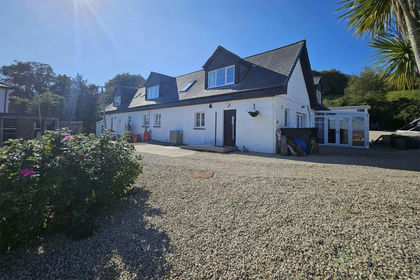
- Price
- Offers Over£450,000
- Size
- 2.19 acres
Added on 13/05/2026House with Land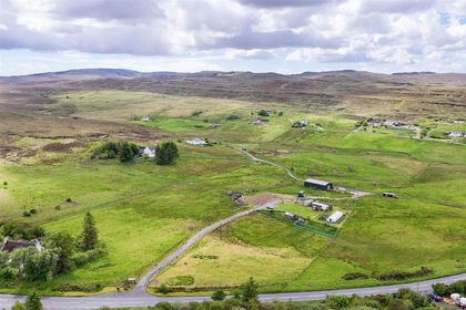
- Price
- Guide Price£270,000
- Size
- 12 acres
An Croit Croft, Highland, Inverness, Skye and West Ross-shire, Highland IV51 Scotland
Added on 02/07/2026Smallholding