Porth Yr Ogof, Ystradfellte, Aberdare, CF44
- Land size
- 44.48 acres
- Bedrooms
- 3
- Bathrooms
- 1
Key Features
- Partially Renovated Farmhouse
- Stunning views across adjoining farmland
- Set within Approximately 44.48 acres of Pasture & Woodland
- Traditional Buildings with redevelopment potential (STP)
- Located a short distance from the Ystradfellte Four Waterfalls
Description
Porth Yr Ogof presents a rare opportunity to acquire an attractive smallholding within the Bannau Brycheiniog National Park, enjoying stunning views and a highly desirable rural setting. Comprising a partially renovated farmhouse, a range of traditional and modern buildings, and approximately 44.48 acres of pasture and woodland, the property offers excellent scope for further improvement.
Located close to the renowned ‘Four Waterfalls’ and Porth Yr Ogof caves, the property is well positioned for tourism or diversified income opportunities, subject to the necessary consents.
Situation
Situated on the edge of the popular village of Ystradfellte within the Bannau Brycheiniog National Park, the property enjoys an enviable rural setting in an area renowned for its natural beauty.
Located close to the famous ‘Four Waterfalls’ walk and Porth Yr Ogof caves, the area attracts visitors year-round. Despite its peaceful surroundings, the property is well placed for access to Brecon (approx. 21 miles) and the A470 and A465, providing links to Merthyr Tydfil, Cardiff and Swansea.
Accommodation
Porth Yr Ogof has been the subject of substantial structural and internal redevelopment, presenting an exciting opportunity to create a significant and highly individual farmhouse with considerable scope for further enhancement.
At ground floor level, the current owners have undertaken extensive works, including the opening up of the internal stone walls and fireplace, to create an impressive open-plan living space. This generous area provides a blank canvas, allowing prospective purchasers to design and configure the layout to suit their own requirements, whether as a large open-plan arrangement or subdivided into more traditional rooms.
On the first floor, further extensive renovation works have been carried out, again offering a largely blank canvas. The space is currently arranged by way of stud partitioning to provide three double bedrooms, together with a bathroom (or potential fourth bedroom). The layout offers excellent flexibility for reconfiguration, with additional space available within the eaves providing further potential for extension or storage.
Outside
Externally, significant excavation and groundworks have already been completed, enabling a purchaser to focus on the completion of the farmhouse while offering scope to create formal gardens, parking areas, or landscaped grounds as desired.
Adjoining the farmhouse is a traditional stone barn, finished in a complementary stone and limewash render. This building offers further potential for incorporation into the main dwelling or redevelopment as additional accommodation, subject to the necessary planning consents.
Land and Buildings
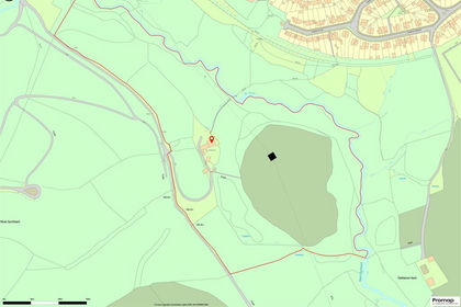
The property extends to approximately 44.48 acres in total, comprising a mix of productive pastureland and woodland. The gently sloping pasture is well suited to both mowing and grazing, and is divided into a number of useful-sized enclosures. The woodland, centrally located within the holding, provides natural shelter and a high degree of privacy.
Part of the land benefits from a mains water supply via troughs, and the boundaries are predominantly stock-proof, comprising sheep fencing complemented by mature hedgerows.
The farmstead includes a substantial concrete and hardcore yard, together with a steel portal frame agricultural building measuring approximately 60ft x 30ft, with an adjoining lean-to (60ft x 15ft) currently utilised for cattle cubicles. The building features poured concrete walls with Yorkshire boarding above, all beneath a fibre cement roof (which may contain asbestos).
In addition, there is a traditional stone barn extending to approximately 75ft x 25ft, offering excellent potential for conversion or redevelopment, subject to the necessary planning consents.
Further land may be available by separate negotiation.
Diversification Potential
Located within close proximity to Ystradfellte and the renowned ‘Four Waterfalls’, Porth Yr Ogof presents attractive opportunities for diversification and tourism-related income.
Services
Mains electricity and mains water supply to the farmhouse. There is currently no heating system installed. Mains water is available to some field parcels, natural water supplies available to fields adjoining river.
Directions
Postcode: CF44 9JF
What3words: ///polo.hence.regal
From Ystradfellte Village, head south east, signposted Penderyn. Crossing over the river, continue for approximately 300 yards, where the entrance and track to Porth Yr Ogof will be located on your right.
Access
Access to the property is granted direct off an unnamed public adopted highway.
Method of Sale
Porth Yr Ogof is offered for sale by Private Treaty.
Boundaries
The purchaser(s) shall be deemed to have full knowledge of all boundaries and neither the vendor nor the vendors agents will be responsible for defining the boundaries or the ownership thereof
Sporting, Timber & Minerals
The sporting rights, mineral rights and timber are included within the freehold in so far as they are owned.
Health & Safety
Due to the nature of the property, neither the seller nor agents are responsible for the safety of those viewing. All those viewing the property do so at their own risk.
Wayleave/Easements/Rights of Way
The property is sold subject to and with the benefit of all existing rights and obligations including rights of way, whether public or private, light, support, drainage, water and other obligations, easements, quasi-easements, and all wayleaves whether referred to or not in these particulars.
Disputes
Should any dispute arise as to the boundaries or any point arising in the General Remarks and Stipulations or Particulars of Scale, Schedule, Plan or interpretation of any of them the question shall be referred to the arbitration of the selling agents, whose decision acting as expert shall be final.
Guide Price
Offers in Excess of: £550,000
Fixtures and Fittings
All fixtures and fittings are excluded from the sale unless specifically referred to in these particulars.
Anti Money Laundering
As part of our obligations under the UK Money Laundering Regulations 2017, Herbert R Thomas will require any purchaser to complete our Anti Money Laundering checks via a third party company named CREDAS.
Viewing Arrangements
Viewing to be arranged for daylight hours and by appointment only through the sole agents.
For further information please contact:
Contact: Rob David
Tel:
E-mail:
Contact: Eifion Morgan
Tel:
E-mail:
EPC Rating: E
Disclaimer
These particulars are provided as a general guide only and do not form part of any contract or offer. While believed to be accurate, they are not guaranteed. Some images may include CGI or digitally enhanced furnishings for illustrative purposes only and are not included in the sale. All negotiations must be conducted through Herbert R Thomas.
Map Location
Property details
- Tenure
- Freehold
- Council Tax Band
- F
- Date Posted
- 2026-06-10
Market Value Analysis
Compared with 130 Farms & Smallholdings listings in Wales (25+ acres).
Utilities & Restrictions
Utilities
- Electricity
- Mains
- Water
- Mains
- Heating
- Ask Agent
- Broadband
- Ask Agent
- Sewerage
- Septic Tank / Private
Rights & Restrictions
- Public Rights of Way
- Yes
- Private Rights of Way
- Ask Agent
- Listed Property
- Ask Agent
- Restrictions
- Ask Agent
Listed status, conservation areas and planning constraints for this location are in the full report.
Property Features
- Accessibility
- Ask Agent
- Parking
- Parking Available
- Garden
- Garden
Beyond the particulars: planning activity, flood history, heritage and ground risks, checked for this exact spot.
Connectivity
Broadband
Available at this postcode
Under 10 Mbps here
Suitable for
- Basic browsing & email
Fixed wireless access may also be an option here.
Mobile signal
Predicted 4G and 5G signal; indoor signal depends on building materials.
Ofcom Connected Nations postcode-level predictions. Speeds and signal are modelled, not measured, and vary between addresses and providers.
Signal is the easy part. Planning activity, flood history and protected designations here are in the full report.
Nearest Schools
Primary
- Penderyn Primary3.2 miles
- Pupils
- 194
- Type
- Nursery, Infants & Juniors
- Language
- Welsh medium school / provision (including transitional)
- Cwmnedd Primary School5 miles
- Pupils
- 172
- Type
- Nursery, Infants & Juniors
- Language
- English medium school / provision
- YGG Cwm Nedd5 miles
- Pupils
- 143
- Type
- Nursery, Infants & Juniors
- Language
- Welsh medium school / provision (including transitional)
- Hirwaun Primary School5.1 miles
- Pupils
- 294
- Type
- Nursery, Infants & Juniors
- Language
- English medium school / provision
- Maesmarchog Community Primary School5.2 miles
- Pupils
- 83
- Type
- Nursery, Infants & Juniors
- Language
- English medium school / provision
Secondary
- Ysgol Gyfun Rhydywaun5.5 miles
- Pupils
- 1,030
- Type
- Secondary (ages 11-19)
- Language
- Welsh medium school / provision (including transitional)
- St John Baptist CIW High School7.4 miles
- Pupils
- 946
- Type
- Secondary (ages 11-19)
- Language
- English medium school / provision
- Pen-Y-Dre High School7.8 miles
- Pupils
- 893
- Type
- Secondary (ages 11-16)
- Language
- English medium school / provision
- Aberdare Community School8 miles
- Pupils
- 1,227
- Type
- Secondary (ages 11-19)
- Language
- English medium school / provision
- Blessed Carlo Acutis Catholic School8.4 miles
- Pupils
- 989
- Type
- Middle (ages 3-16)
- Language
- English medium school / provision
Distances are straight-line from the advertised location. Source: the national school registers (DfE, Welsh Government, Scottish Government) and Ofsted.
Schools are just the start: sold prices nearby, planning activity and any flood history are in the full report.
Amenities
Supermarket
GP surgery
Pharmacy
Straight-line distances from the advertised location. Sources: NHS records, Geolytix supermarket locations, OS Open Greenspace and the national trails registers.
The area stacks up? Now check the location itself: planning nearby, protected designations and past flooding.
Getting Around
Nearest station
Nearest bus stop
Typical drive times
Straight-line distances from the advertised location; drive times are typical free-flow times over OpenStreetMap road data, so allow more at peak. Public transport locations from DfT NaPTAN.
Easy to reach matters. So do planning activity, flood history and ground risks: all in the full report.
Flood Risk
Natural Resources Wales open data, checked around the advertised map pin for the listed acreage. Long-term risk counts flood defences; the planning map's flood zones do not. Provided by LandSale, not the listing agent, and not part of the agent's particulars. Risk varies across a holding, so verify before committing.
Rivers and the sea
Not at the pin: mapped about 110 metres away.
Planning map: Flood Zone 3, about 100 metres away.
Surface water
Not at the pin: mapped about 10 metres away.
These bandings are the summary. Where this location sits on the flood maps, plus planning activity, heritage and ground risks, is in the full report.
Important notice: Information, maps and tags on this page are drawn from the advertising agent's marketing materials or generated automatically. LandSale has not verified them. Relying on these details is at your own risk, always carry out independent checks before committing to a purchase.
LandSale full disclaimer
Marketing information only - not formal particulars. The details on this website are provided for general guidance and do not constitute an offer or contract. Neither LandSale nor the advertising estate/land agent accepts responsibility for any inaccuracy.
1. Source of information
- Listing content: Core description, asking price, tenure, measurements, photographs and planning history originate from the marketing materials of the advertising estate or land agent. LandSale does not author this content and cannot guarantee its accuracy.
- Automated tags & categorisation: Property type, land-use class, acreage bands and similar labels may be applied by machine-learning models. They are intended as a helpful guide only and may not reflect the property's legal status or permitted use.
- Third-party & enriched data layers: Maps, boundary outlines, planning designations, soil reports, broadband coverage and other environmental or location-based insights are licensed from external suppliers. Such data are supplied “as is", may be incomplete or out of date and are subject to change without notice.
2. Verification required
Prospective purchasers must verify critical matters, including but not limited to planning permission, title boundaries, public rights of way, environmental constraints, acreage, services, access and VAT status, through their own inspections, specialist surveys, legal advisers and the selling agent before relying on the information or entering into any contract.
3. No warranty or liability
LandSale gives no warranty, express or implied, as to the accuracy, completeness or fitness for any particular purpose of the information displayed. LandSale shall not be liable for any loss, damage, cost or expense arising directly or indirectly from any use of or reliance on such information, save where liability may not be excluded by law.
4. Updates & feedback
If you believe any detail on this listing is inaccurate, please let us know. We will investigate and, where appropriate, update the listing or notify the agent.
© LandSale | Version 1.3 - August 2026
Similar properties for sale
- Price
- Guide Price£425,000
- Size
- 28.87 acres
Sychpant Farm, Maesteg Maesteg, Bridgend County Borough CF34, Maesteg, Bridgend CF34 Wales
Added on 30/09/2026Smallholding
- Price
- £500,000
- Size
- 28 acres
Llangadog, Towy Valley, Llangadog, Carmarthenshire SA19 Wales
Added on 29/01/2026Smallholding
- Price
- £550,000
- Size
- 45 acres
Talley, Llandeilo, Carmarthenshire., Talley, Carmarthenshire SA19 Wales
Added on 24/08/2026Smallholding
- Price
- Guide Price£475,000
- Size
- 27 acres
Llanellen, Abergavenny, Llanfoist Fawr, Monmouthshire NP7 Wales
Added on 13/10/2026Smallholding
- Price
- £595,000
- Size
- 46 acres
Gwernogle, Carmarthen, Carmarthenshire., Llanfihangel Rhos-y-Corn, Carmarthenshire SA32 Wales
Added on 29/01/2026Livestock Farm
- Price
- Guide Price£630,000
- Size
- 23 acres
Parc Y Rhos, Cwmann, Lampeter, Pencarreg, Carmarthenshire SA48 Wales
Added on 23/09/2026Smallholding
- Price
- Guide Price£450,000
- Size
- 95.9 acres
Trimsaran, Kidwelly, SA17, Trimsaran, Carmarthenshire SA17 Wales
Added on 18/03/2026Pasture
- Price
- £595,000
- Size
- 30 acres
Bettws Bledrws, Lampeter, SA48, Llangybi, Ceredigion SA48 Wales
Added on 07/10/2026Smallholding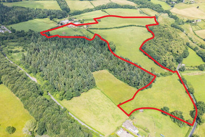
- Price
- Guide Price£675,000
- Size
- 44.1 acres
Llwyn-y-Celyn Farm Lot 3, Shirenewton, Chepstow, NP16, Shirenewton, Monmouthshire NP16 Wales
Added on 29/01/2026Farm