High Spen, Rowlands Gill, Tyne and Wear, NE39
Description
The sale of land at High Spen offers an excellent opportunity to acquire a well-located and accessible block of productive grassland, benefiting from roadside access. The land lies approximately 3 miles from the popular village of Rowlands Gill.
• Extending in total 14.64 hectares (36.17 acres)
• Productive grade 3 grassland
• Roadside access
• Investment opportunity
• Diversification and/or Environmental potential
DESCRIPTION
The sale of land at High Spen offers an excellent opportunity to acquire a productive block of bare agricultural land. The land is currently laid to grass and has been used for grazing, with the parcels closest to the road also suitable for mowing.
In total, the land extends to approximately 14.64 hectares (36.17 acres) of productive Grade 3 agricultural land. Soils are predominantly loamy and clayey in nature, typically well suited to grassland production. The land is gently sloping, ranging from approximately 127m to 158m above sea level.
The land is well located, meaning the land is easily accessible for farmers to incorporate into their current farming operations. The property benefits from stock proof boundaries, being primarily stock fencing and mature hedgerows. The land is in good heart and is well drained.
The land also lends itself to a range of alternative uses, including exploring agri environment schemes such as the Sustainable Farming Incentive (SFI) or via a private funding schemes such as biodiversity net gain. It is also well suited to equestrian use or lifestyle purchaser seeking a convenient and easily managed parcel of land.
LOCATION
The land is ideally situated to the south of the village of High Spen, approximately 3 miles north-west of Rowlands Gill, around 1.5 miles south of Greenside, and approximately 3 miles south-west of Chopwell.
In the wider context, Gateshead lies approximately 9 miles to the north-east, with Newcastle upon Tyne approximately 11 miles to the north-east.
The land is highly accessible, with the A69 and A1 both within easy reach.
What3Words: ///fists.incur.waltzed
ACCESS
The land is accessed directly from the public highway along its western boundary on Rogues Lane (B6315). Access points to the property are marked on the sale plan, denoted ‘A’.
ENVIRONMENTAL SCHEMES
There are no land based agri-environmental schemes on the property, however given the nature of the land such schemes could be attractive to a potential purchaser who would benefit from additional income generated as a result.
SERVICES
The land benefits from spring water supply.
OVERAGE
The land hatched blue on the sale plan and other land is affected by an existing overage, whereby an overage payment will arise in the event of certain types of disposals of part or all of the land. Further information is available upon request.
GENERAL REMARKS & STIPULATIONS
METHOD OF SALE
The Property is offered for sale by Private Treaty as a whole. The vendor reserves the right to conclude the sale as they wish. All interested parties should register their interest with us to be kept informed as to how the sale will be concluded.
WAYLEAVES/EASEMENTS/PUBLIC RIGHT OF WAY
The Property is sold subject to all rights including rights of way, whether public or private, rights of light, support, drainage, water and electricity supplies and other rights, obligations and easements, quasi easements and restrictive covenants and all existing and proposed wayleaves for masts, pylons, stays, cables, drains and water, gas and other pipes, whether or not constituted in the title deeds or referred to in these particulars.
SPORTING AND MINERAL RIGHTS
The Sporting and Mineral rights are included in the sale in so far as they are owned.
AREAS
The areas and measurements stated have been assessed in accordance with OS data and digital mapping. Interested parties should though satisfy themselves in this regard.
TENURE
Freehold with vacant possession on completion.
ANTI MONEY LAUNDERING REGULATIONS
Prospective Buyers should be aware that in the event that they are successful, they will be required to provide us with documents in relation to Money Laundering Regulations, one being photographic ID, i.e. driving licence or passport and the other being a utility bill showing their address.
LOCAL AUTHORITY
Gateshead County Council. Any enquiries regarding planning or statutory matters should be directed to the Local Authority.
VIEWINGS
Viewings should not be unaccompanied and are by prior appointment only. Arrangements can be made by contacting youngsRPS, Hexham on or katie. / Kate.
Map Location
Property details
- Tenure
- Freehold
- Council Tax Band
- TBC
- Date Posted
- 2026-06-05
Utilities & Restrictions
Utilities
- Electricity
- Ask Agent
- Water
- Ask Agent
- Heating
- Ask Agent
- Broadband
- Ask Agent
- Sewerage
- Ask Agent
Rights & Restrictions
- Public Rights of Way
- Ask Agent
- Private Rights of Way
- Ask Agent
- Listed Property
- Ask Agent
- Restrictions
- Ask Agent
Property Features
- Accessibility
- Ask Agent
- Parking
- Ask Agent
- Garden
- Ask Agent
Important notice: Information, maps and tags on this page are supplied by the advertising agent or generated automatically. LandSale has not verified them. Relying on these details is at your own risk, always carry out independent checks before committing to a purchase.
LandSale full disclaimer
Marketing information only - not formal particulars. The details on this website are provided for general guidance and do not constitute an offer or contract. Neither LandSale nor the advertising estate/land agent accepts responsibility for any inaccuracy.
1. Source of information
- Agent-supplied content: Core description, asking price, tenure, measurements, photographs and planning history are uploaded by the appointed agent, who remains solely responsible for their accuracy.
- Automated tags & categorisation: Property type, land-use class, acreage bands and similar labels may be applied by machine-learning models. They are intended as a helpful guide only and may not reflect the property's legal status or permitted use.
- Third-party & enriched data layers: Maps, boundary outlines, planning designations, soil reports, broadband coverage and other environmental or location-based insights are licensed from external suppliers. Such data are supplied “as is", may be incomplete or out of date and are subject to change without notice.
2. Verification required
Prospective purchasers must verify critical matters, including but not limited to planning permission, title boundaries, public rights of way, environmental constraints, acreage, services, access and VAT status, through their own inspections, specialist surveys, legal advisers and the selling agent before relying on the information or entering into any contract.
3. No warranty or liability
LandSale gives no warranty, express or implied, as to the accuracy, completeness or fitness for any particular purpose of the information displayed. LandSale shall not be liable for any loss, damage, cost or expense arising directly or indirectly from any use of or reliance on such information, save where liability may not be excluded by law.
4. Updates & feedback
If you believe any detail on this listing is inaccurate, please let us know. We will investigate and, where appropriate, update the listing or notify the agent.
© LandSale | Version 1.2 - January 2026
Listing agent
youngsRPS, Hexham
Priestpopple Hexham NE46 1PS
Similar properties for sale

- Price
- Offers Over£295,000
- Size
- 38.54 acres
Consett, Durham, DH8, Blaydon and Consett, County Durham DH8 6PY England
Added on 30/05/2026Grazing Land
- Price
- Guide Price£365,000
- Size
- 5.2 acres
Gray Terrace, Stanley, County Durham, DH9, Stanley, County Durham DH9 7LB England
Added on 29/01/2026Self Build Plot
- Price
- Offers Over£225,000
- Size
- 66.74 acres
Middle Horsleyhope Farm, Consett,, Muggleswick, County Durham DH8 9DE England
Added on 30/05/2026Grazing Land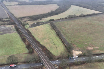
- Price
- Offers in Excess of£350,000
- Size
- 71.24 acres
Finchale Road, Newton Hall, Durham, City of Durham, County Durham DH1 5PS England
Added on 17/07/2026Farm
- Price
- Guide Price£260,000
- Size
- 48.21 acres
Land at Middleburn Farm, Simonburn, Wark, Northumberland NE48 3EE England
Added on 19/05/2026Grazing Land
- Price
- £250,000
- Size
- 171.51 acres
Land At Nenthead, Alston, Alston Moor, Westmorland and Furness CA9 3LW England
Added on 26/02/2026Grazing Land