Bredfield, Nr Woodbridge, Suffolk
- Land size
- 1.25 acres
Description
Planning permission was granted at Appeal on 16th January 2024 for the erection of five detached houses with a new shared access, on a site that extends to approximately 1.25 acres (0.5 hectares) in all in the popular rural village of Bredfield, just to the north of Woodbridge.
Location
The site is set along The Street in the centre of the village, adjacent to the village hall and bowling green. The village benefits from a community run village shop and well supported village hall. Bredfield is only three miles from the historic market town of Woodbridge, which is situated on the banks of the River Deben and provides an excellent array of facilities including shops, boutiques, restaurants, a swimming pool, theatre and cinema, doctors' surgery and railway station. Trains from the station connect to Ipswich with some direct trains through to London's Liverpool Street station. There are several sailing clubs and marinas in the town, and various golf courses within a few miles. Woodbridge also has excellent schooling in both the state and private sector. The County town of Ipswich lies about 10 miles to the south-west and other areas of the Heritage Coast are within easy reach with the popular centres including Orford, Aldeburgh, Thorpeness and Southwold.
Directions
Proceeding in a northly direction along the A12, bypass the town of Woodbridge. After approximately half a mile turn left where signposted to Bredfield and Debach. After approximately one mile turn right at the pump and continue towards the centre of the village. The site will be found immediately after the village hall on the right hand side.
For those using the What3Words app: ///firebird.seaside.enacted
Description
Planning permission was granted at Appeal on 16th January 2024 for the erection of five dwellings with associated parking and vehicular access - Appeal reference APP/X3540/W/23/3317919.
The development provides for a scheme of five detached dwellings comprising one 3 bedroom bungalow, two 3 bedroom houses and two 4 bedroom houses on a site that extends to approximately 1.25 acres (0.5 hectares). A schedule of the proposed accommodation, together with extracts of the consented plans, are included within these sales particulars.
Plot
Number Description SQ FT SQM
1 3 bedroom detached bungalow 1012 94
2 3 bedroom detached house 1274 118
3 4 bedroom detached house 1561 145
4 4 bedroom detached house 1539 143
5 3 bedroom detached house 1270 118
TOTAL 6656 618
Each of the properties have been designed in a contemporary fashion with a mixture of brick and vertical boarding elevations set beneath natural slate roofs and with aluminium anthracite grey framed windows and doors. The properties will be accessed from a new, shared entrance, that will serve a shared driveway arrangement. Each of the plots will enjoy extremely generous east facing rear gardens, that will back onto open agricultural land with stunning, uninterrupted views across the gently undulating countryside.
CIL
The planning permission is subject to the local planning authority’s Community Infrastructure Levy (CIL) and a CIL Liability Notice was subsequently issued following the grant of planning permission at Appeal confirming that the amount of CIL payable was £237,740.78 - Reference LN00006551 - although we understand that this amount is subject to indexation. Any detailed enquiries relating to CIL should be referred to the local planning authority, East Suffolk Council - or .
Proposed Terms of Sale
The extent of the site being offered for sale is as per the indicative plan included within these sale particulars with the area to be sold edged red.
The vendors will also include an obligation within the sale contract for the purchaser to fence the boundaries marked A-B-C to a minimum standard of post and two rail design to include rabbit proof fencing.
A 7m wide field access to the north of the site is to be retained to serve the agricultural land to the east.
A covenant will be included within the sale contract limiting the development to no more than five dwellings.
It should be noted that land drains currently cross the site, but these can be removed by the developer during the course of construction.
Suitable easements will be put in place for the purchaser to remove the overhead electricity cable and re-route the underground, which will be partly within the retained land. If required, an easement for drainage rights into the ditch line to the north of the site will also be provided.
An area of additional land is available by separate negotiation. This is indicatively edged blue on the proposed site plan and extends to approximately half an acre. This is available for £25,000, subject to contract. If this additional land is required the same fencing obligations will be applied.
Services
We understand that a mains electricity supply is located overhead and that mains water and drainage are located in the public highway. We also understand a mains gas supply is available in the village too. Nevertheless, prospective purchasers will need to satisfy themselves with regard to the location and capacity of any services.
The high voltage overhead electricity supply that currently crosses the site is to be removed and relocated underground. The vendors have obtained a quotation for those works from UK Power Networks. The date of the quotation was 29th September 2025 and the price, excluding VAT, was £94,200.58 on the basis that UKPN carries out both the contestable and non-contestable works required. A copy of the quotation is available on request. As this quotation is now over 6 months old, the vendors have requested an updated quote from UKPN.
Architects
Nicholas Jacob Architects, The Christies, 5 Wherry Quay, Ipswich IP4 1AS; Tel: ; Email:
Local Authority
East Suffolk Council; East Suffolk House, Station Road, Melton, Woodbridge, Suffolk IP12 1RT; Tel:
Viewing
By prior appointment with the selling agents and thereafter with particulars in hand.
NOTES
1. Every care has been taken with the preparation of these particulars, but complete accuracy cannot be guaranteed. If there is any point, which is of particular importance to you, please obtain professional confirmation. Alternatively, we will be pleased to check the information for you. These Particulars do not constitute a contract or part of a contract. All measurements quoted are approximate. The Fixtures, Fittings & Appliances have not been tested and therefore no guarantee can be given that they are in working order. Photographs are reproduced for general information and it cannot be inferred that any item shown is included. No guarantee can be given that any planning permission or listed building consent or building regulations have been applied for or approved. The agents have not been made aware of any covenants or restrictions that may impact the property, unless stated otherwise. Any site plans used in the particulars are indicative only and buyers should rely on the Land Registry/transfer plan.
2. The Money Laundering, Terrorist Financing and Transfer of Funds (Information on the Payer) Regulations 2017 require all Estate Agents to obtain sellers’ and buyers’ identity.
3. The site comprises two separate Title numbers. The entirety of the Title numbers will be sold, although part of the land is likely to fall outside the red line planning area.
4. The additional land that is available by separate negotiation will be sold as agricultural land. It if it to be incorporated within the gardens of the proposed development, then planning permission is likely to be required.
June 2026
Map Location
Property details
- Tenure
- Freehold
- Council Tax Band
- Ask Agent
- Date Posted
- 2026-06-04
Market Value Analysis
Compared with 160 Development Land listings in East Anglia (1+ acres).
Utilities & Restrictions
Utilities
- Electricity
- Ask Agent
- Water
- Ask Agent
- Heating
- Ask Agent
- Broadband
- Ask Agent
- Sewerage
- Ask Agent
Rights & Restrictions
- Public Rights of Way
- Ask Agent
- Private Rights of Way
- Ask Agent
- Listed Property
- Ask Agent
- Restrictions
- Ask Agent
Listed status, conservation areas and planning constraints for this location are in the full report.
Property Features
- Accessibility
- Ask Agent
- Parking
- Parking Available
- Garden
- Garden
Beyond the particulars: planning activity, flood history, heritage and ground risks, checked for this exact spot.
Connectivity
Broadband
Fastest speed available at this postcode
1.8 Gbps
Gigabit full fibre
Suitable for
- 4K streaming on every screen
- Full-time home working
- Online gaming & big downloads
Mobile signal
Predicted 4G and 5G signal; indoor signal depends on building materials.
Ofcom Connected Nations postcode-level predictions. Speeds and signal are modelled, not measured, and vary between addresses and providers.
Signal is the easy part. Planning activity, flood history and protected designations here are in the full report.
Nearest Schools
Primary
- Melton Primary School1.9 milesOfsted report card · Jan 2026
- Ages
- 3 to 11
- Pupils
- 163
- Type
- Community school
- Woodbridge Primary School2.3 milesOfsted: Good *
- Ages
- 3 to 11
- Pupils
- 209
- Type
- Community school
- Charsfield Church of England Primary School2.3 milesNo Ofsted rating
- Ages
- 4 to 11
- Pupils
- 34
- Type
- Academy converter
- Faith
- Church of England
- St Mary's Church of England Primary School, Woodbridge2.5 milesNo Ofsted rating
- Ages
- 4 to 11
- Pupils
- 198
- Type
- Academy converter
- Faith
- Church of England
- Wickham Market Primary School2.5 milesNo Ofsted rating
- Ages
- 3 to 11
- Pupils
- 163
- Type
- Academy converter
Secondary
- Farlingaye High School2.1 milesOfsted report card · May 2026
- Ages
- 11 to 18
- Pupils
- 1,861
- Type
- Academy converter
- Kesgrave High School5.3 milesOfsted: Good
- Ages
- 11 to 18
- Pupils
- 1,875
- Type
- Academy converter
- St Alban's Catholic High School6.7 milesOfsted: Good
- Ages
- 11 to 18
- Pupils
- 967
- Type
- Academy converter
- Faith
- Roman Catholic
- Thomas Mills High School & Sixth Form6.8 milesOfsted: Good
- Ages
- 11 to 18
- Pupils
- 1,056
- Type
- Academy converter
- Northgate High School7 milesOfsted: Good *
- Ages
- 11 to 18
- Pupils
- 1,750
- Type
- Community school
* Latest graded judgement covers quality of education only; no overall grade was issued under the 2024-25 inspection framework.
Distances are straight-line from the advertised location. Source: the national school registers (DfE, Welsh Government, Scottish Government) and Ofsted.
Schools are just the start: sold prices nearby, planning activity and any flood history are in the full report.
Amenities
Supermarket
GP surgery
Pharmacy
Hospital
Green space
Straight-line distances from the advertised location. Sources: NHS records, Geolytix supermarket locations, OS Open Greenspace and the national trails registers.
The area stacks up? Now check the location itself: planning nearby, protected designations and past flooding.
Getting Around
Nearest station
Nearest bus stop
Typical drive times
Straight-line distances from the advertised location; drive times are typical free-flow times over OpenStreetMap road data, so allow more at peak. Public transport locations from DfT NaPTAN.
Easy to reach matters. So do planning activity, flood history and ground risks: all in the full report.
Flood Risk
Environment Agency open data, checked around the advertised map pin for the listed acreage. Long-term risk counts flood defences; the planning map's flood zones do not. Provided by LandSale, not the listing agent, and not part of the agent's particulars. Risk varies across a holding, so verify before committing.
Rivers and the sea
Planning map: Flood Zone 1.
Surface water
These bandings are the summary. Where this location sits on the flood maps, plus planning activity, heritage and ground risks, is in the full report.
Important notice: Information, maps and tags on this page are drawn from the advertising agent's marketing materials or generated automatically. LandSale has not verified them. Relying on these details is at your own risk, always carry out independent checks before committing to a purchase.
LandSale full disclaimer
Marketing information only - not formal particulars. The details on this website are provided for general guidance and do not constitute an offer or contract. Neither LandSale nor the advertising estate/land agent accepts responsibility for any inaccuracy.
1. Source of information
- Listing content: Core description, asking price, tenure, measurements, photographs and planning history originate from the marketing materials of the advertising estate or land agent. LandSale does not author this content and cannot guarantee its accuracy.
- Automated tags & categorisation: Property type, land-use class, acreage bands and similar labels may be applied by machine-learning models. They are intended as a helpful guide only and may not reflect the property's legal status or permitted use.
- Third-party & enriched data layers: Maps, boundary outlines, planning designations, soil reports, broadband coverage and other environmental or location-based insights are licensed from external suppliers. Such data are supplied “as is", may be incomplete or out of date and are subject to change without notice.
2. Verification required
Prospective purchasers must verify critical matters, including but not limited to planning permission, title boundaries, public rights of way, environmental constraints, acreage, services, access and VAT status, through their own inspections, specialist surveys, legal advisers and the selling agent before relying on the information or entering into any contract.
3. No warranty or liability
LandSale gives no warranty, express or implied, as to the accuracy, completeness or fitness for any particular purpose of the information displayed. LandSale shall not be liable for any loss, damage, cost or expense arising directly or indirectly from any use of or reliance on such information, save where liability may not be excluded by law.
4. Updates & feedback
If you believe any detail on this listing is inaccurate, please let us know. We will investigate and, where appropriate, update the listing or notify the agent.
© LandSale | Version 1.3 - August 2026
Listing agent
Clarke and Simpson, Framlingham
Well Close Square, Framlingham, IP13 9DU
View agent profileSimilar properties for sale
- Price
- Guide Price£425,000
Little Bealings, Nr Woodbridge, Suffolk, Little Bealings, Suffolk IP13 England
Added on 29/01/2026Development Land
- Price
- Guide Price£400,000
Hollesley, Woodbridge, IP12, Hollesley, Suffolk IP12 England
Added on 30/04/2026Development Land
- Price
- Offers Over£450,000
- Size
- 0.25 acres
Residential Development Site, Dock Street, Ipswich, Ipswich, Suffolk IP2 England
Added on 05/10/2026Development Land Added on 08/07/2026Development Land
- Price
- £400,000
- Size
- 0.83 acres
Added on 23/07/2026Development Land
- Price
- Guide Price£395,000
Added on 29/01/2026Building Plot
- Price
- £490,000
- Size
- 1.36 acres
Added on 28/01/2026Development Land
- Price
- Offers in Excess of£420,000
Added on 13/08/2026Warehouse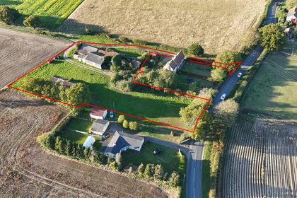
- Price
- Guide Price£575,000
- Size
- 1.32 acres
Potash Farm Development Site, Ipswich Road, Holbrook, Suffolk, IP9, Holbrook, Suffolk IP9 England
Added on 29/01/2026Development Land
- Price
- Guide Price£500,000
Church Road, Wilby, Eye, Suffolk, IP21, Wilby, Suffolk IP21 England
Added on 22/06/2026Building Plot