REDEVELOPMENT SITE, Langport, TA10
- Land size
- 4.2 acres
Key Features
- Resolution to Grant Outline Planning (Ref.21/02785/OUT)
- Total land area approx. 1.70 ha (4.20 acres)
- Informal Tender Wednesday 8th July 2026
Description
THE SITE - TA10 0NQ
An opportunity to acquire a brownfield development site with a resolution to grant an Outline Planning Permission (Ref.21/02785/OUT) for the proposed redevelopment for residential development in this semi-rural location on the outskirts of Langport.
The site extends in total to approximately 1.70 hectares (4.20 acres), with the red lined area for the current planning application extending to approximately 1.15 hectares (2.84 acres). The application proposes demolition of the former nursing home and associated outbuildings, with an indicative layout plan showing 24 new dwellings, with a reduced level of affordable housing at 25%.
PLEASE NOTE: There are a pair of semi-detached houses located to the rear of the old nursing home which do not form part of the site and are in a different ownership. They have rights of access over the track along to the southwest.
PLEASE NOTE: The adjoining land to the east also has a Resolution to Grant planning permission (Ref.23/01406/OUT) for up to 22 dwellings. GTH are marketing this site and prospective purchasers may consider purchasing both sites to create a larger comprehensive scheme.
VIEWING - STRICTLY BY APPOINTMENT ONLY
Please contact the agents to arrange a viewing.
SERVICES
Interested parties should make and rely upon their own enquiries of the relevant services providers.
SITUATION
The Grange is located on the Western outskirts of Langport a short distance from the town on the A378. Langport town centre offers an excellent range of everyday amenities including a selection of shops, a supermarket, churches, bank, doctors and dentists surgeries. Langport also benefits from a Library, public houses and restaurants. There are also schools for all ages including the Huish Episcopi Academy and Sixth Form. There are railway stations located in Taunton, Castle Cary and Yeovil. The property is also well served with road links with the A303 and M5 situated within easy reach.
SERVICES
Interested parties should make and rely upon their own enquiries of the relevant services providers.
METHOD OF SALE
Informal Tender with best & final bids invited for this freehold property by midday on Wednesday 8th July 2026. Offers are invited on an unconditional basis, assuming grant of Outline Planning Permission (Ref.21/02785/OUT).
VALUE ADDED TAX
The seller has not opted to tax, therefore VAT will not be payable in addition to the purchase price.
OVERAGE
Our client's preference is for an overage provision to be contained within the sale contract, the details of the overage are subject to further discussion.
RANSOM STRIP
Our client is considering retaining ransom strips around the perimeter of the site or a positive covenant over the blue outlined area, although the details are subject to further discussion.
RIGHTS OF WAY, WAYLEAVES AND EASEMENTS
The sale is subject to all rights of support, public and private rights of way, water, light, drainage and other easements, quasi-easements, all or any other like rights, whether mentioned in these particulars or not.
TENURE & POSSESSION
The seller owns the freehold (title absolute) of the site being offered for sale. It is registered with the Land Registry under title number: WS81964.
LOCAL PLANNING AUTHORITY
Somerset Council
County Hall, The Crescent, Taunton, TA1 4DY
DIRECTIONS
SAT Nav = TA10 0NQ
What3words: lines.accompany.motored
PLANNING
Somerset Council resolved to grant outline planning permission (Ref.21/02785/OUT), subject to completion of the S106 legal agreement. All matters are reserved except access, for proposed redevelopment of buildings and associated land for residential development at The Grange, Portway, Langport, TA10 0NQ.
We understand that the draft Section 106 Agreement contributions, in total, are approximately £85,575 (Education contribution removed following Officer report). Please note this figure may vary as the Agreement is subject to legal negotiation, number of dwellings and indexation.
Due to the Vacant Building Credit Policy and the existing buildings on the site, there is a reduction in the affordable housing requirement to 25%. There will be Community Infrastructure liability in respect of the development, although this will be calculated and confirmed once the Reserved Matters permission is granted.
The Phosphate mitigation strategy shall consist of the acquisition of credits from an established third-party provider, with the overarching legal agreement with Somerset Council, as detailed within No.20 of the Planning Conditions of the Planning Permission. However, all interested parties should confirm these points independently with the Local Planning Authority.
Copies of the proposed plans, reports, draft S106 & draft planning conditions are held on file by the agents.
Map Location
Property details
- Tenure
- Freehold
- Council Tax Band
- Ask Agent
- Date Posted
- 2026-06-03
Utilities & Restrictions
Utilities
- Electricity
- Ask Agent
- Water
- Ask Agent
- Heating
- Ask Agent
- Broadband
- Ask Agent
- Sewerage
- Ask Agent
Rights & Restrictions
- Public Rights of Way
- Ask Agent
- Private Rights of Way
- Ask Agent
- Listed Property
- Ask Agent
- Restrictions
- Ask Agent
Property Features
- Accessibility
- Ask Agent
- Parking
- Ask Agent
- Garden
- Ask Agent
Important notice: Information, maps and tags on this page are supplied by the advertising agent or generated automatically. LandSale has not verified them. Relying on these details is at your own risk, always carry out independent checks before committing to a purchase.
LandSale full disclaimer
Marketing information only - not formal particulars. The details on this website are provided for general guidance and do not constitute an offer or contract. Neither LandSale nor the advertising estate/land agent accepts responsibility for any inaccuracy.
1. Source of information
- Agent-supplied content: Core description, asking price, tenure, measurements, photographs and planning history are uploaded by the appointed agent, who remains solely responsible for their accuracy.
- Automated tags & categorisation: Property type, land-use class, acreage bands and similar labels may be applied by machine-learning models. They are intended as a helpful guide only and may not reflect the property's legal status or permitted use.
- Third-party & enriched data layers: Maps, boundary outlines, planning designations, soil reports, broadband coverage and other environmental or location-based insights are licensed from external suppliers. Such data are supplied “as is", may be incomplete or out of date and are subject to change without notice.
2. Verification required
Prospective purchasers must verify critical matters, including but not limited to planning permission, title boundaries, public rights of way, environmental constraints, acreage, services, access and VAT status, through their own inspections, specialist surveys, legal advisers and the selling agent before relying on the information or entering into any contract.
3. No warranty or liability
LandSale gives no warranty, express or implied, as to the accuracy, completeness or fitness for any particular purpose of the information displayed. LandSale shall not be liable for any loss, damage, cost or expense arising directly or indirectly from any use of or reliance on such information, save where liability may not be excluded by law.
4. Updates & feedback
If you believe any detail on this listing is inaccurate, please let us know. We will investigate and, where appropriate, update the listing or notify the agent.
© LandSale | Version 1.2 - January 2026
Listing agent
KLP, Exeter
Newcourt Barton Clyst Road, Topsham, EX3 0DB
Similar properties for sale
- Price
- £1,815,000
- Size
- 3.5 acres
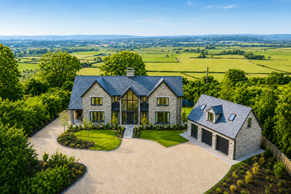
Wood Drove, Bowdens, Huish Episcopi, Somerset TA10 0DD England
Added on 11/07/2026Self Build Plot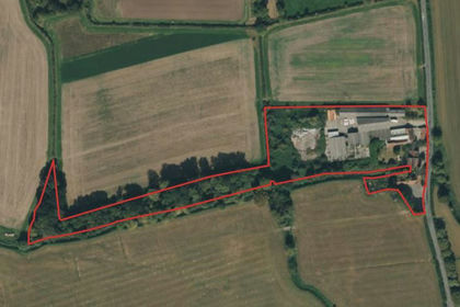
- Price
- Guide Price£600,000
- Size
- 6 acres
Added on 26/02/2026Development Land
- Price
- POA
- Size
- 3.91 acres
Walton, Street, Somerset, BA16, Walton, Somerset BA16 9QQ England
Added on 29/01/2026Development Land
- Price
- £1,500,000
- Size
- 2.87 acres
Added on 14/04/2026Development Land
- Price
- Guide Price£2,000,000
- Size
- 3.71 acres
Batt Drive, Maidenbrook, Nr. Taunton, Somerset, TA2, Taunton, Somerset TA2 8FW England
Added on 15/04/2026Development Land
- Price
- POA
- Size
- 41.25 acres
Bunford Park, Western Relief Road, Yeovil, BA20 2HT, West Coker, Somerset BA20 2HT England
Added on 13/06/2026Development Land
- Price
- POA
- Size
- 7.66 acres
Added on 29/01/2026Development Land
- Price
- POA
- Size
- 7 acres
Added on 11/04/2026Development Land
- Price
- POA
- Size
- 7 acres
Added on 11/04/2026Development Land- Price
- POA
- Size
- 7 acres
Added on 11/04/2026Development Land